Aboriginal Land Rights (Northern Territory) Amendment Act 1989
No. 2 of 1990
An Act to amend the Aboriginal Land Rights (Northern Territory) Act 1976
[Assented to 17 January 1990]
BE IT ENACTED by the Queen, and the Senate and the House of Representatives of the Commonwealth of Australia, as follows:
Short title etc.
1. (1) This Act may be cited as the Aboriginal Land Rights (Northern Territory) Amendment Act 1989.
(2) In this Act, “Principal Act” means the Aboriginal Land Rights (Northern Territory) Act 19761.
Commencement
2. This Act commences on the day on which it receives the Royal Assent.
Interpretation
3. Section 3 of the Principal Act is amended:
(a) by inserting in the definition of “exploration retention lease” in subsection (1) “or exploration retention licence” after “lease” (second occurring);
(b) by omitting from subsection (1) the definitions of “exploration licence”, “intending miner” and “mining interest” and substituting respectively the following definitions:
“ ‘exploration licence’ includes:
(a) a prospecting authority; and
(b) a permit in respect of land under the Petroleum (Prospecting and Mining) Act 1954 of the Northern Territory; and
(c) a permit granted under the Petroleum Act 1984 of the Northern Territory; and
(d) a right to explore for minerals under:
(i) if subsection 53 (2a) of the Lands Acquisition Act 1955 applies by virtue of subsection 124 (8) of the Lands Acquisition Act 1989—the first- mentioned subsection; or
(ii) if subparagraph (i) does not apply—regulations made for the purposes of subsection 124 (1) of the Lands Acquisition Act 1989;
‘intending miner’, in respect of Aboriginal land, means:
(a) a person who makes application, under a law of the Northern Territory relating to mining for minerals, for the grant of a mining interest in respect of that land, while the person:
(i) holds an exploration licence under that law in respect of that land; or
(ii) being a person who has held an exploration licence in respect of that land, holds under that law an exploration retention lease or exploration retention licence, or has made an application for the grant of such a lease or licence, in respect of that land or a part of that land; or
(b) a person who:
(i) if subsections 51 (1a) and 53 (2a) of the Lands Acquisition Act 1955 apply by virtue of subsection 124 (8) of the Lands Acquisition Act 1989—makes an application, under subsection 51 (1a) of the first-mentioned Act for the grant of a lease or licence to mine for
minerals on that land, while the person holds, under subsection 53 (2a) of that Act, a right to explore for minerals on that land; or
(ii) if subparagraph (i) does not apply—makes an application for the grant, under regulations made for the purposes of subsection 124 (1) of the Lands Acquisition Act 1989, of a right to mine for, or recover, minerals on that land, while the person holds, under the regulations, a right to explore for minerals on that land;
‘mining interest’ means:
(a) any lease or other interest in, or right in respect of, land granted under a law of the Northern Territory relating to mining for minerals (other than a lease or other interest in land, or a right, relating to the mining or development of extractive mineral deposits); or
(b) if subsections 51 (1a) and 53 (2a) of the Lands Acquisition Act 1955 apply by virtue of subsection 124 (8) of the Lands Acquisition Act 1989—any lease, licence or other right granted under any of those provisions; or
(c) if regulations have been made for the purposes of subsection 124 (1) of the Lands Acquisition Act 1989—any right granted under those regulations to explore for, mine for, or recover, minerals;
but does not include, when the expression is used in Part IV, any such lease, licence, interest or right that is an exploration licence or exploration retention lease;”;
(c) by inserting the following definition in subsection (1):
“ ‘Incorporated Aboriginal Association’ has the same meaning as in the Aboriginal Councils and Associations Act 1976;".
4. Section 4 of the Principal Act is amended by inserting after subsection (1) the following subsection:
“(1aa) A Land Trust to hold any Crown land described in Part 2 or 3 of Schedule 1 must be established not later than 2 years after the commencement of this subsection.”.
5. Section 23 of the Principal Act is amended by inserting after paragraph (1) (f) the following paragraph:
“(fa) to negotiate, and enter into agreements, as necessary, for the purposes of subsection 70 (4);”.
Application of money of Land Council
6. Section 35 of the Principal Act is amended:
(a) by omitting paragraph (1) (b) and substituting the following paragraphs:
“(b) any Incorporated Aboriginal Association whose members live in the area of the Land Council; and
(c) any association of Aboriginals, or company whose shareholders are all Aboriginals, incorporated under a law of the Northern Territory:
(i) whose members or shareholders live in the area of the Land Council; and
(ii) that has been declared by the Minister to be eligible to receive payments under this subsection;”;
(b) by omitting from paragraphs (2) (b) and (3) (b) “incorporated Aboriginal communities or groups” and substituting “Incorporated Aboriginal Associations”;
(c) by omitting from subsection (9) “incorporated Aboriginal community or group” and substituting “Incorporated Aboriginal Association”;
(d) by omitting subsection (12) and substituting the following subsection:
“(12) Where an Aboriginal community or group that is not an Incorporated Aboriginal Association was, before the commencement of this subsection, entitled to be paid an amount under this section, the community or group is taken, for the purposes of this section, to be an Incorporated Aboriginal Association.”.
Grants of exploration licences
7. Section 40 of the Principal Act is amended by inserting “(including Aboriginal land in a conservation zone)” after “Aboriginal land”.
Terms and conditions of exploration licences
8. Section 44a of the Principal Act is amended by adding at the end of subsection (2) “and such period (if any) immediately following that period as is specified in the agreement.”.
9. After section 48a of the Principal Act the following section is inserted:
Special provisions relating to specified areas
“48aa. (1) This section applies to:
(a) the Aboriginal land described in Schedule 3, being the land known as the Eastern Areas on Groote Eylandt; and
(b) if:
(i) the boundaries of the area known as the Coronation Hill Project Area are prescribed for the purposes of this section; and
(ii) any land within the boundaries so prescribed becomes Aboriginal land;
that Aboriginal land.
“(2) Except as otherwise provided in this section, the preceding provisions of this Part do not apply to Aboriginal land to which this section applies.
“(3) An exploration licence in respect of Aboriginal land to which this section applies must not be granted unless the applicant for the licence has entered into an agreement in writing with the relevant Land Council on the terms and conditions of the grant of the licence.
“(4) The applicant shall:
(a) submit to the Land Council, in writing, a comprehensive proposal including, but not limited to, the particulars set out in paragraphs 41 (6) (a) to (f), inclusive; and
(b) cause a copy of the proposal to be sent to the Minister.
“(5) Where the applicant and the Land Council fail to agree upon the terms and conditions within 12 months after receipt of the proposal by the Land Council, the applicant or the Land Council, or both, may, in writing, request the Minister to refer the terms and conditions to a person appointed by the Minister as a Mining Commissioner for determination by conciliation, or, failing that, by arbitration.
“(6) Where such a request is made, subsections 44 (5) to (11) (inclusive) apply.
“(7) Section 44a applies, with the necessary changes, to terms and conditions agreed upon or determined under this section.
“(8) A mining interest in respect of Aboriginal land to which this section applies must not be granted to an applicant unless the relevant Land Council and the applicant have entered into an agreement in writing as to the terms and conditions of the grant of the interest.
“(9) Section 46 applies, with the necessary changes, to the grant of a mining interest in respect of the land.”.
Offence in connection with mining interest
10. Section 48j of the Principal Act is amended by omitting from subsection (1) “or subsection (2)”.
Functions of Commissioner
11. Section 50 of the Principal Act is amended by omitting paragraph (2e) (b).
Payments into Trust Account
12. Section 63 of the Principal Act is amended by omitting subsection (3) and substituting the following subsections:
“(3) Where, because of an increase in the rate of royalty since the commencement of this section, an amount of royalties received by the Commonwealth in respect of a mining interest in the area of Aboriginal land described in Schedule 5 is higher than the amount that, but for that increase, the Commonwealth would have received in respect of that mining interest, such part only of the increase in the amount of those royalties as is determined by the Minister is to be taken into account in calculating the amount payable into the Trust Account under subsection (2) in respect of those royalties.
“(3a) Where:
(a) after the commencement of this subsection, a mining interest in respect of Aboriginal land in the Northern Territory has been granted under:
(i) subsection 51 (1a) of the Lands Acquisition Act 1955 in so far as it applies by virtue of subsection 124 (8) of the Lands Acquisition Act 1989; or
(ii) regulations made for the purposes of subsection 124 (1) of the Lands Acquisition Act 1989; and
(b) because of an increase in the rate of royalty since the grant of the mining interest, an amount of royalties received by the Commonwealth in respect of the mining interest is higher than the amount that, but for that increase, the Commonwealth would have received in respect of that mining interest;
such part only of the increase in the amount of those royalties as is determined by the Minister is to be taken into account in calculating the amount payable into the Trust Account under subsection (2) in respect of those royalties.”.
13. After section 77b of the Principal Act the following section is inserted:
Amendment of Schedule 1
“77c. (1) Subject to subsection (2), the regulations may amend Schedule 1 by modifying any description of an area of land in Part 2 or 3 of that Schedule and, on the commencement of an amendment, that Schedule has effect as so amended.
“(2) Regulations for the purposes of subsection (1) may not modify the description of an area of land after title in the land has been vested in a Land Trust under this Act.
“(3) In this section:
‘modifying’ includes the substitution of a description or diagram for another description or diagram.”.
Schedule 1
14. Schedule 1 to the Principal Act is amended:
(a) by inserting “PART 1” before the item referring to “ALLIGATOR RIVERS (No. 1)”;
(b) by adding at the end the Parts set out in Schedule 1 to this Act.
Schedule 3
15. Schedule 3 to the Principal Act is amended by omitting “Section 40” and substituting “Section 48aa”.
New Schedule
16. The Principal Act is amended by adding at the end the Schedule set out in Schedule 2 to this Act.
Amendment of the Aboriginal Land Rights (Northern Territory) Amendment Act 1987
17. Section 34 of the Aboriginal Land Rights (Northern Territory) Amendment Act 1987 is repealed.
Amendment of the Aboriginal Land Rights (Northern Territory) Amendment Act (No. 3) 1987
18. Section 8 of the Aboriginal Land Rights (Northern Territory) Amendment Act (No. 3) 1987 is amended by omitting paragraph (b)
_____________
SCHEDULE 1 Paragraph 14 (b)
PARTS TO BE ADDED TO SCHEDULE 1 TO PRINCIPAL ACT
PART 2
AMMAROO LOCALITY
All those pieces of land in the Northern Territory of Australia containing an area of 2819 hectares more or less.
Firstly:
All that parcel of land approximately 10 kilometres northerly from Ammaroo Homestead in the Northern Territory of Australia containing an area of 2560 hectares more or less and bounded by lines described as follows: Commencing at the northeastern corner of Northern Territory Portion 1583 then by lines bearing 270 degrees 144.6 metres; 360 degrees 935.26 metres; 90 degrees 5090 metres; 180 degrees 5089 metres; 270 degrees 5088 metres; 360 degrees 2544.6 metres; 90 degrees 144.6 metres; 360 degrees 1609.34 metres to the point of commencement.
Secondly:
All that parcel of land being Northern Territory Portion 1583 containing an area of 259 hectares more or less and being more particularly delineated on Survey Plan S77/84 lodged with the Northern Territory Surveyor-General, Darwin.
BIRDUM (JOMMET BLOCK) LOCALITY
All that parcel of land in the Northern Territory of Australia containing an area of 81000 hectares more or less commencing at the southwest corner of Northern Territory Portion 645 (Elsey) and thence easterly along the southern boundary of the said Northern Territory Portion thence southerly partly along a western boundary of Northern Territory Portion 645 and the western boundary of Northern Territory Portion 699 (Maryfield) to the northern boundary of an area “set aside for Public Trucking Yards” thence westerly along the said northern boundary and its prolongation to the western boundary of Northern Territory Portion 3673 thence in a southwesterly direction to the most northern corner of Northern Territory Portion 3050 thence again southwesterly by the northern boundary of the said Northern Territory Portion to the southeastern corner of Northern Territory Portion 2732 (Gorrie) thence in a northwesterly direction to the point of commencement but excluding Northern Territory Portion 1433 being more particularly delineated on Survey Plan S72/218 lodged with the Northern Territory Surveyor-General, Darwin and those parts of the Stuart Highway, Western Creek Road and Northern Territory Portion 3673 that lie within the area thus described.
DRY RIVER STOCK RESERVE LOCALITY
All that parcel of land approximately 70 kilometres north of the Town of
SCHEDULE 1—continued
Top Springs in the Northern Territory of Australia containing an area of 20700 hectares more or less and bounded by lines described as follows: Commencing at the northeastern corner of Pastoral Lease 782 (Killarney) thence westerly by part of the northern boundary of the said Pastoral Lease to the southernmost southeast corner of NT Portion 3413 thence northerly for 16093.44 metres and easterly for 12881.73 metres, being an eastern and a southern boundary of NT Portion 3413, thence southerly by part of a western boundary of Pastoral Lease 934 (NT Portion 2665) to the point of commencement.
ELLIOTT LOCALITY
All that parcel of land in the Northern Territory of Australia containing an area of 2780 hectares more or less surrounding No. 8 Bore (Kulamindini) on the Newcastle Waters to Queensland Border Stock Route commencing at a point 2787.48 metres north of No. 8 Bore; bounded thence by lines east for 2787.89 metres; thence south for 5574.97 metres; thence west for 5574.16 metres; thence north for 5574.97 metres; thence east for 2787.89 metres to the point of commencement but excluding:
Firstly:
All that piece of land containing an area of 225 hectares more or less commencing at a point on the southwestern side of the Stuart Highway bearing 303 degrees 28 minutes 30 seconds 765.05 metres from the most easterly corner of Lot No. 20, Elliott Townsite; thence by lines bearing 213 degrees 28 minutes 30 seconds 688.85 metres; thence 123 degrees 28 minutes 30 seconds for about 2642 metres to its intersection with a line bearing 213 degrees 28 minutes 30 seconds from the most easterly corner of Lot No. 62, Elliott Townsite; thence on a bearing of 33 degrees 28 minutes 30 seconds by the last mentioned line and its northeasterly prolongation and passing through the most easterly corner of Lot No. 62 for 853.44 metres; thence on a bearing of 303 degrees 28 minutes 30 seconds for about 2642 metres; thence on a bearing of 213 degrees 28 minutes 30 seconds for 164.59 metres to the point of commencement.
Secondly:
All that parcel of land containing an area of 2.16 hectares more or less being Northern Territory Portion 1462 and being more particularly delineated on Survey Plan S73/45 lodged with the Surveyor-General, Darwin.
Thirdly:
All those parcels of land containing an area of 748 square metres more or less being Lot 111 Town of Elliott and being more particularly delineated on Survey Plan S80/78 lodged with the Surveyor-General, Darwin.
Fourthly:
All that parcel of land containing an area of 2.72 hectares more or less and known as an area for cattle yards and dip commencing at a point on the southwestern side of the Stuart Highway bearing 303 degrees 28 minutes 30
SCHEDULE 1—continued
seconds 826.2 metres; 330 degrees 43 minutes 164.9 metres; 240 degrees 43 minutes 50 metres; 330 degrees 43 minutes for approximately 298 metres from the most eastern corner of Lot No. 20, Elliott Townsite; thence lines bearing 240 degrees 43 minutes 127.64 metres; 330 degrees 43 minutes 213.36 metres; 60 degrees 43 minutes 127.64 metres; 150 degrees 43 minutes 213.36 metres to the point of commencement.
Fifthly:
Those parts of the Stuart Highway included in the area described.
MITTIEBAH LOCALITY
All that parcel of land situated at Connell’s Bore approximately 40 kilometres northwest of Alexandria Aerodrome in the Northern Territory of Australia containing an area of 3108 hectares more or less being Northern Territory Portion 562 and being more particularly delineated on survey plan A.176 lodged with the Surveyor-General, Darwin.
MT PEACHY (MARYVALE) LOCALITY
All those parcels of land in the Northern Territory of Australia containing an area of 8535 hectares more or less.
Firstly:
All that parcel of land near Maryvale Pastoral Lease Northern Territory of Australia containing an area of 65 square kilometres more or less bounded by lines described as follows: Commencing at the most northern northwestern corner of Northern Territory Portion 810 (Maryvale); thence northerly and easterly by part of an eastern boundary of the Hugh River Stock Route and part of an eastern boundary and a southern boundary of Northern Territory Portion 652 (Orange Creek) to a point on a western boundary of Northern Territory Portion 415 (Deep Well); thence southerly by part of the said western boundary of the said Northern Territory Portion and its prolongation southerly to its intersection with the northern boundary of Northern Territory Portion 810 (Maryvale); thence westerly by part of the said northern boundary of the said Northern Territory Portion to the point of commencement.
Secondly:
All that parcel of land approximately 12 kilometres southwesterly from Deep Well Homestead in the Northern Territory of Australia containing an area of 535 hectares more or less and bounded by lines described as follows: Commencing at a point bearing 184 degrees 39 minutes 113.33 metres from the northwestern corner of Northern Territory Portion 1933 thence by lines bearing 184 degrees 39 minutes 744.59 metres; 177 degrees 14 minutes 3264.03 metres; 183 degrees 4 minutes 30 seconds 644.58 metres; 270 degrees 2 minutes 30 seconds 1740.5 metres; 360 degrees 1626 metres; 29 degrees 4 minutes 3454.05 metres to the point of commencement.
SCHEDULE 1—continued
Thirdly:
All that parcel of land containing an area of 1500 hectares more or less being that part of the Hugh River Stock Route that joins Reserve 1653 and Reserve 1780 described firstly and secondly.
MT SOLITAIRE (HAMILTON DOWNS) LOCALITY
All those pieces of land in the Northern Territory of Australia containing an area of 2867 hectares more or less.
Firstly:
All that parcel of land near the town of Alice Springs in the Northern Territory of Australia containing an area of 1424 hectares more or less being Northern Territory Portion 803 and being more particularly delineated on Survey Plan A226 lodged with the Surveyor-General, Darwin.
Secondly:
All that parcel of land approximately 30 kilometres northwest of the Town of Alice Springs in the Northern Territory of Australia containing an area of 1443 hectares more or less and bounded by lines described as follows: Commencing at the southeastern corner of Northern Territory Portion 803 thence by lines bearing 0 degrees 1 minute 20 seconds 2796.19 metres; 93 degrees 40 minutes 20 seconds 3931.55 metres; 180 degrees 0 minutes 20 seconds 4564.42 metres; 297 degrees 14 minutes 20 seconds 4411.88 metres to the point of commencement.
OORATIPPRA LOCALITY
All those parcels of land in the Northern Territory of Australia containing an area of 22040 hectares more or less.
Firstly:
All that parcel of land containing an area of 19940 hectares more or less being Northern Territory Portion 484 and being more particularly delineated on Survey Plan OP1309 lodged with the Surveyor-General, Darwin but excluding those parts of the Sandover Highway which lie within the area thus described.
Secondly:
All that parcel of land being part of the Sandover Stock Route containing an area of 2100 hectares more of less commencing at the southeast corner of Northern Territory Portion 484 thence southerly along the prolongation of the eastern boundary of the aforesaid Northern Territory Portion about 1753 metres; thence in a westerly direction parallel to and 1609.3 metres south of the southern boundary of Northern Territory Portion 484 to the intersection of the prolongation of the western boundary of the aforesaid portion.
SCHEDULE 1—continued
RANKEN RIVER LOCALITY
All those pieces of land in the Northern Territory of Australia containing an area of 3785 hectares more or less.
Firstly:
All that parcel of land situated near Ranken River in the Northern Territory of Australia approximately 75 kilometres northwest of the Avon Downs Police Station containing an area of 2675 hectares more or less and bounded by lines described as follows: Commencing at the southernmost corner of Northern Territory Portion 1285 thence by lines bearing 30 degrees 31 minutes 1609.34 metres; 318 degrees 12 minutes 3359.08 metres; 210 degrees 30 minutes 242.19 metres; thence by a line bearing 303 degrees 54 minutes to its intersection with the right bank of the Ranken River; thence generally northeasterly by the said right bank to its intersection with an east west line being 4828 metres north of the southernmost corner of Northern Territory Portion 1285; thence east to a point 4828 metres north and 5230 metres east of the southernmost corner of Northern Territory Portion 1285; thence south for 4828 metres; thence west for 5230 metres to the point of commencement.
Secondly:
All that parcel of land situated near Ranken River in the Northern Territory of Australia approximately 75 kilometres northwest of the Avon Downs Police Station containing an area of 1110 hectares more or less and bounded by lines described as follows: Commencing at the southernmost corner of Northern Territory Portion 1285 thence by lines bearing 318 degrees 11 minutes 3358.5 metres; 30 degrees 31 minutes 1030.52 metres; 30 degrees 30 minutes 257.35 metres; 303 degrees 54 minutes 373.37 metres; 315 degrees 1570 metres; 225 degrees 1609.3 metres thence by a line bearing 135 degrees to the right bank of the Ranken River thence generally southwesterly by the said bank to a point due west of the southernmost corner of Northern Territory Portion 1285 thence east by a line for about 4800 metres to the point of commencement.
SOUDAN LOCALITY
All that parcel of land near Soudan Homestead in the Northern Territory of Australia containing an area of 1554 hectares more or less and bounded by lines described as follows:
Commencing at a point 128.26 metres east and thence 2374.26 metres south from the southeastern corner of Northern Territory Portion 1411 thence by lines bearing 270 degrees 3941.5 metres; 360 degrees 3942 metres; 90 degrees 3942.5 metres; 180 degrees 3942 metres to the point of commencement but excluding therefrom Northern Territory Portion 1411.
TARLTON DOWNS LOCALITY
All that parcel of land approximately 35 kilometres northeasterly from
SCHEDULE 1—continued
Tarlton Downs Homestead in the Northern Territory of Australia containing an area of 20100 hectares more or less bounded by lines described as follows:
Commencing at the northernmost northeastern corner of Pastoral Lease 898 (Tarlton Downs) thence easterly southerly and westerly by part of a southern boundary a western boundary and a northern boundary of Pastoral Lease 770 (Manners Creek) to the southernmost northwestern corner of the said Pastoral Lease thence northerly westerly and again northerly by part of an eastern boundary a northern boundary and an eastern boundary of Pastoral Lease 898 (Tarlton Downs) to the point of commencement.
UNDOOLYA BORE LOCALITY
All that parcel of land approximately 20 kilometres east of Alice Springs in the Northern Territory of Australia containing an area of 1424 hectares more or less and bounded by lines described as follows:
Commencing at Mt Undoolya trigonometrical station thence by lines bearing 90 degrees 3774.5 metres; 180 degrees 3774 metres; 270 degrees 3773.5 metres; 360 degrees 3774 metres to the point of commencement.
PART 3
16 MILE (BOND SPRINGS) LOCALITY
All those parcels of land in the Northern Territory of Australia containing an area of 4289 hectares more or less.
Firstly:
All that parcel of land containing an area of 3599 hectares more or less being part of Northern Territory Portion 515 Bond Springs Locality but excluding therefrom that part of Northern Territory Portion 515 containing an area of 230.3 hectares more or less and bounded by lines described as follows:
Commencing at the southernmost southwestern corner of Northern Territory Portion 515 thence by lines bearing 358 degrees 31 minutes 30 seconds for about 795.7 metres; 79 degrees 59 minutes 40 seconds for about 3405.8 metres; 232 degrees 13 minutes 40 seconds 1320.08 metres; 220 degrees 41 minutes 20 seconds 851.89 metres; 264 degrees 24 minutes 10 seconds 1693.31 metres to the point of commencement;
and excluding further Northern Territory Portions 3370, 1799, 1800 and 1557 being more particularly delineated on Survey Plans S87/48, S79/82, S79/82 and S76/110 respectively, lodged with the Northern Territory Surveyor-General, Darwin.
Secondly:
All that parcel of land containing an area of 690 hectares more or less being that part of the North South Stock Route commencing at the northern boundary of Northern Territory Portion 515 Bond Springs Locality and
SCHEDULE 1—continued
continuing north to the southern bank of 16 Mile Creek as shown hatched on the following diagram:

SCHEDULE 1—continued
ALICE WELL LOCALITY
All that parcel of land in the Northern Territory of Australia containing an area of 1000 hectares more or less being that part of the Southern Stock Route as shown hatched on the following diagram-
SCHEDULE 1—continued
BLACK TANK BORE (BOND SPRINGS) LOCALITY
All those parcels of land in the Northern Territory of Australia containing an area of 3550 hectares more or less.
Firstly:
All that parcel of land approximately 43 kilometres northeasterly from the Town of Alice Springs in the Northern Territory of Australia containing an area of 2590 hectares more or less and bounded by lines described as follows:
Commencing at a point due north of Black Tank Bore on the southern boundary of Northern Territory Portion 641 (Yambah) thence easterly by part of the said boundary for 2545 metres thence by lines bearing 180 degrees 5089 metres; 270 degrees 5088 metres; 360 degrees to the southern boundary of Northern Territory Portion 641 (Yambah) thence easterly by part of the said boundary to the point of commencement.
Secondly:
All that parcel of land approximately 50 kilometres northeasterly from the Town of Alice Springs in the Northern Territory of Australia containing an area of 960 hectares more or less being that part of the Sandover Stock Route as shown hatched on the following diagram:

SCHEDULE 1—continued
FINKE LOCALITY
All those parcels of land in the Northern Territory of Australia containing an area of 14080 hectares more or less.
Firstly:
All that parcel of land near the Town of Finke in the Northern Territory of Australia containing an area of 6956 hectares more or less and bounded by lines described as follows: Commencing at the northernmost northwestern corner of Northern Territory Portion 431 thence by lines bearing 179 degrees 59 minutes 10 seconds 4827.85 metres; 89 degrees 59 minutes 50 seconds 1609.95 metres; 180 degrees 3218.69 metres; 269 degrees 59 minutes 30 seconds 1849.4 metres to the centreline of the disused Alice Springs Port Augusta Railway; 270 degrees 0 minutes 30 seconds 4645.79 metres; 270 degrees 3160.87 metres; 360 degrees 8046.7 metres; 90 degrees 8045.47 metres to the point of commencement but excluding therefrom the Town of Finke as described in Northern Territory Gazette No. 35 of 31 August 1955, and the Railway Reserve as defined by lines 60.35 metres either side of and parallel to the centreline of the disused Alice Springs Port Augusta Railway.
Secondly:
All that parcel of land near the Town of Finke in the Northern Territory of Australia containing an area of 777.4 hectares more or less and bounded by lines described as follows: Commencing at the southwestern corner of Northern Territory Portion 431 thence by lines bearing 359 degrees 59 minutes 10 seconds 4827.85 metres; 89 degrees 59 minutes 10 seconds 1610.59 metres; 179 degrees 59 minutes 4828.01 metres; 269 degrees 59 minutes 50 seconds 1609.95 metres to the point of commencement.
Thirdly:
All that parcel of land near the Town of Finke in the Northern Territory of Australia containing an area of 242.2 hectares more or less being Northern Territory Portion 453 and being more particularly delineated on Survey Plan OP1283 lodged with the Surveyor-General, Darwin.
Fourthly:
All that parcel of land approximately 34 kilometres south west of the Town of Finke in the Northern Territory of Australia containing an area of 2590 hectares more or less and bounded by lines described as follows: Commencing at the easternmost northeastern corner of NT Portion 2869 (Umbeara) thence by lines bearing 90 degrees 5090 metres; 180 degrees 5089 metres; 270 degrees 5088 metres; 360 degrees 5089 metres to the point of commencement.
Fifthly:
All that parcel of land approximately 50 kilometres south east of the Town of Finke in the Northern Territory of Australia containing an area of 2590 hectares more or less and bounded by lines described as follows: Commencing at a point 2544.5 metres east of Charlotte Waters Bore thence by lines
SCHEDULE 1—continued
bearing 180 degrees 2544.5 metres; 270 degrees 5088 metres; 360 degrees 5089 metres; 90 degrees 5090 metres; 180 degrees 2544.5 metres to the point of commencement.
Sixthly:
All that parcel of land approximately 17 kilometres south west of the Town of Finke in the Northern Territory of Australia containing an area of 925 hectares more or less being that part of the Goyder Stock Route as shown hatched on the following diagram:

SCHEDULE 1—continued
FORSTER RANGE (STIRLING) LOCALITY
All those parcels of land in the Northern Territory of Australia containing an area of 4310 hectares more or less being those parts of the North South Stock Route as shown hatched on the following diagram:

SCHEDULE 1—continued
HENBURY/ORANGE CREEK LOCALITY
All those parcels of land in the Northern Territory of Australia containing an area of 9100 hectares more or less being those parts of the Hugh River Stock Route as shown hatched on the following diagram but excluding Northern Territory Portion 2049.

SCHEDULE 1—continued
JINKA LOCALITY
All that parcel of land near Pastoral Homestead Lease 4 (Jinka) in the Northern Territory of Australia containing an area of 1772 hectares more or less being that part of Reserve No. 1779, described in Northern Territory Government Gazette No. S89, 23 December 1986, as shown hatched on the following diagram:

SCHEDULE 1—continued
LORNE CREEK LOCALITY
All that parcel of land in the Northern Territory of Australia containing an area of 3720 hectares more or less being that part of the Barkly Stock Route as shown hatched on the following diagram:

SCHEDULE 1—continued
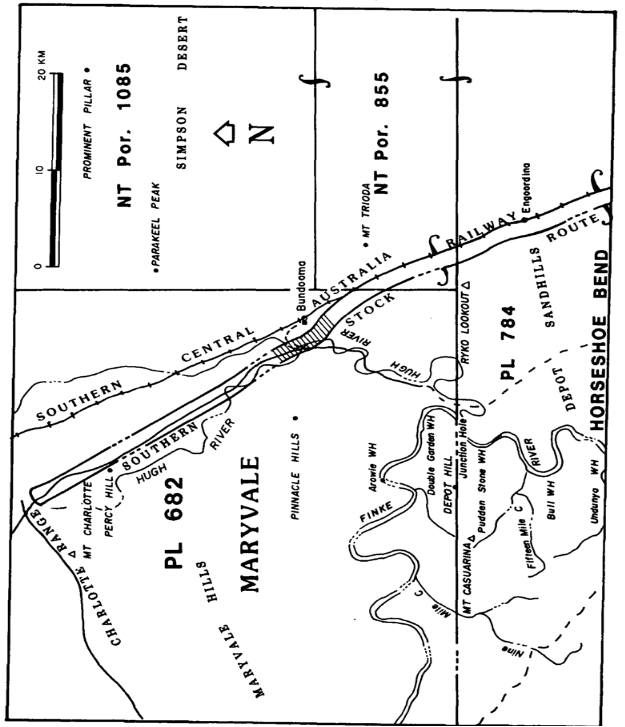
MT KATHLEEN (LOVES CREEK) LOCALITY
All those parcels of land in the Northern Territory of Australia containing an area of 5404 hectares more or less.
Firstly:
All that parcel of land near Numery Homestead in the Northern Territory of Australia containing an area of 4470 hectares more or less and bounded by lines described as follows:
Commencing at the intersection of the northern boundary of the Phillipson Stock Route with a western boundary of Pastoral Lease 557 (Numery) thence by lines bearing 237 degrees 46 minutes 2987.4 metres; 310 degrees 6 minutes 6672.8 metres; 360 degrees 43 minutes 2586.28 metres; 44 degrees 54 minutes 1925.76 metres; 121 degrees 14 minutes 1316.54 metres; 91 degrees 47 minutes 3803.16 metres; 90 degrees 1312.66 metres; 180 degrees 5856.48 metres to the point of commencement.
Secondly:
All that parcel of land near Numery Homestead in the Northern Territory of Australia containing an area of 934 hectares more or less being that part of the Phillipson Stock Route as shown hatched on the following diagram:
SCHEDULE 1—continued
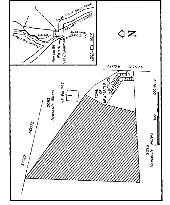
NEWCASTLE WATERS LOCALITY
All that parcel of land situated at the Town of Newcastle Waters in the Northern Territory of Australia containing an area of 215 hectares more or less being that part of Reserve 1791, described in Northern Territory Government Gazette No. S89, 23 December 1986, as shown hatched on the following diagram: