Notice: A279293
Commonwealth of Australia
OFFSHORE PETROLEUM AND GREENHOUSE GAS STORAGE ACT 2006
PROHIBITION OF ENTRY INTO A PETROLEUM SAFETY ZONE
I, Ian MacGillivray, a representative of the National Offshore Petroleum Safety and Environmental Management Authority [NOPSEMA], pursuant to section 616 of the Offshore Petroleum and Greenhouse Gas Storage Act 2006, hereby prohibit all vessels other than vessels under the control of ROC Oil (Vic) Pty Limited the registered holders of VIC/L26 and vessels operated by authorised persons who are exercising powers under section 615(1) of Division 1 of Part 6.6 of the above Act from entering or being present in the area of the petroleum safety zones without the consent in writing of NOPSEMA.
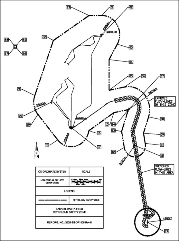
The petroleum safety zones specified in this notice cover three locations and extend to the following;
- A distance of 500 metres, around the Basker - Manta - Gummy Field Infrastructure,
- A distance of 360 metres, around the Basker-6 wellhead; and,
- A distance of 75 metres around the former Basker Spirit Mooring Location.
The petroleum safety zones are measured from each point of the outer edge of the wellheads, manifolds and former Basker Spirit Mooring Location as represented in the following drawing and coordinate table.
The petroleum safety zone will be valid from 20 February 2013 and remain until revoked by notice published in the gazette.
Where an unauthorised vessel enters or remains in the safety zone specified in contravention of this notice, the owner and the person in command or in charge of the vessel are each guilty of an offence against Section 616 of the Act and are punishable, upon conviction, by imprisonment for a term:
• not exceeding 15 years if the breach is determined as intentional.
• not exceeding 12.5 years if the breach is determined as recklessness.
• not exceeding 10 years if the breach is determined as negligence.
• not exceeding 5 years if the breach is determined as an offence of strict liability.
Petroleum Safety Zone Boundary- MGA Coordinates (GDA94) | |||
No | Latitude S | Longitude E | Comments |
01 | 381623.21” | 1484257.63” |
|
02 | 381639.42” | 1484258.01” | Manta-2A, CNTR 500m RAD |
03 | 381647.27” | 1484316.02” |
|
04 | 381700.48” | 1484306.75” |
|
05 | 381726.45” | 1484307.36” |
|
06 | 381723.47” | 1484325.02” |
|
07 | 381742.50” | 1484330.18” | Same as 14, CNTR 600m RAD |
08 | 381748.32” | 1484353.75” |
|
09 | 381802.21” | 1484348.23” |
|
10 | 381810.86” | 1484350.38” |
|
11 | 381812.72” | 1484338.26” | CNTR 300m RAD |
12 | 381814.59” | 1484326.14” |
|
13 | 381801.11” | 1484322.79” |
|
14 | 381742.50” | 1484330.18” | Same as 07 |
15 | 381745.32” | 1484313.44” |
|
16 | 381801.06” | 1484244.69” |
|
17 | 381758.74” | 1484224.32” | Manifold, CNTR 500m RAD |
18 | 381809.40” | 1484208.80” |
|
19 | 381748.07” | 1484145.23” |
|
20 | 381737.42” | 1484200.75” | CNTR 500m RAD |
21 | 381732.15” | 1484141.28” |
|
22 | 381645.22” | 1484201.72” |
|
23 | 381623.42” | 1484242.63” |
|
24 | 381917.54” | 1484354.70” | Basker-6, CNTR 360m RAD |
25 | 381649.77” | 1484119.26” | Former Basker Spirit Mooring location |
26 | 381652.20” | 1484119.32” | Former Basker Spirit Mooring location |
27 | 381652.25” | 1484116.23” | Former Basker Spirit Mooring location |
28 | 381649.81” | 1484116.18” | Former Basker Spirit Mooring location |
*Note: the above are GDA94 coordinates.
Dated this 11 day of February 2013.
Made under the Offshore Petroleum and Greenhouse Gas Storage Act 2006 of the Commonwealth of Australia.
Ian MacGillivray
Pursuant to the Instrument of delegation dated 30 April 2012
National Offshore Petroleum Safety and Environmental Management Authority