| ||
|

Maritime Transport and Offshore Facilities Security Act 2003
Notice of declaration of security regulated port – Port walcott – cape lambert
I, BRIAN RANKIN, Ag Regional Director, Transport Security Operations-Perth, Office of Transport Security, under subsection 13(1) of the Maritime Transport and Offshore Facilities Security Act 2003 (the Act):
REVOKE the declaration of the security regulated port of Port Walcott published in the Gazette (No. S 189, 4 June 2004) on Line no. 26 of Column A (the port) and shown on the map identified as ‘26. Port Walcott’ on page 30; and
DECLARE that the area of the port of Port Walcott intended for use either wholly or partly in connection with the movement, loading, unloading, maintenance or provisioning of security regulated ships, the boundaries of which are shown on the attached map and descriptions, to be a security regulated port.
This Notice commences upon publication in the Gazette.
Date: 7 June 2013
Brian Rankin
Delegate of the Secretary of the
Department of Infrastructure and Transport
Note:
1) Gazette means the Commonwealth of Australia Gazette
2) This Notice remains in force until otherwise revoked in writing and upon subsequent publication in the Gazette.
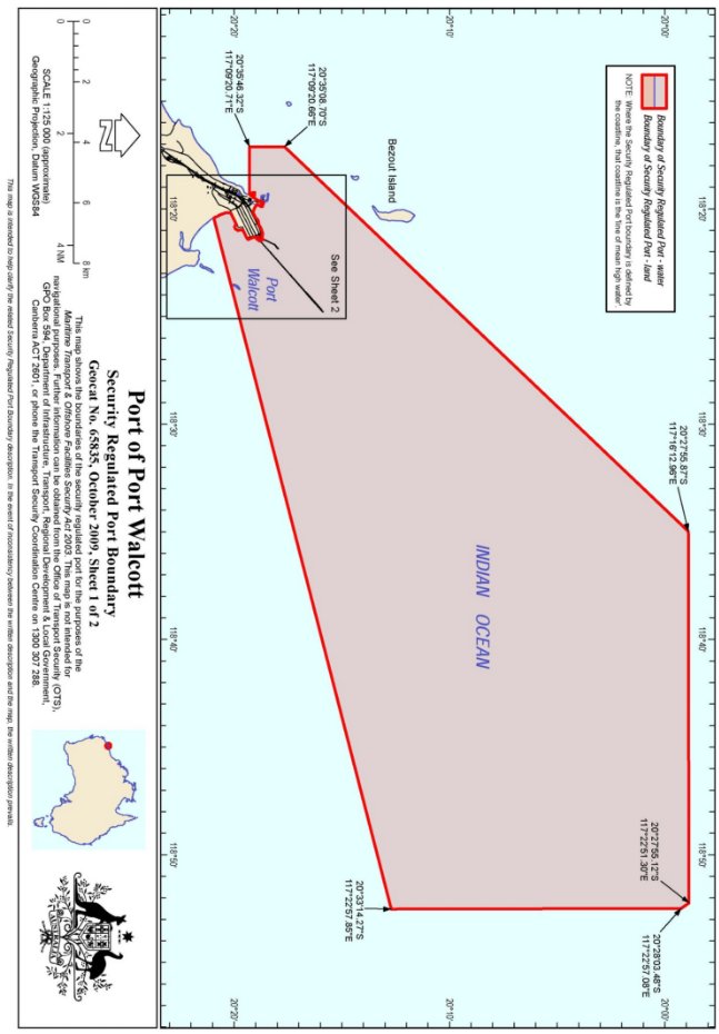

SECURITY REGULATED PORT BOUNDARY DESCRIPTION
Description of Port of Port Walcott
State: Western Australia
Map Number: 65835
1. The Security Regulated Port of Port Walcott is all of that area of land and water contained within and bounded by a line commencing at a point on the high water mark of the coastline of Western Australia west of Cape Lambert at latitude 20º 35’ 46.22” south, longitude117º 10’ 11.83” east;
2. Thence westerly along the geodesic to a point at latitude 20º 35’ 46.32” south longitude 117º 09’ 20.71” east;
3. Thence northerly along the geodesic to a point at latitude 20º 35’ 08.70” south, longitude 117º 09’ 20.66” east;
4. Thence north-easterly along the geodesic to a point at latitude 20º 27’ 55.87” south, longitude 117º 16’ 12.96” east;
5. Thence easterly along the geodesic to its intersection with the limit of the territorial sea of Australia closest to latitude 20° 27' 55.12” south, longitude 117° 22' 51.30" east;
6. Thence generally south-easterly along that limit of the territorial sea to a point on that limit closest to latitude 20° 28' 03.48"south, longitude 117° 22' 57.08"east;
7. Thence southerly along the geodesic to a point at latitude 20º 33’ 14.27” south, longitude 117º 22’ 57.85” east;
8. Thence south-westerly along the geodesic to a point on the high water mark of the coastline of Western Australia closest to latitude 20º 36’ 24.41” south, longitude 117º 10’ 37.11” east;
9. Thence initially north-westerly but generally north-easterly along that high water mark for a distance of approximately 2.2 kilometres to the point of intersection with the south-eastern side of the Port Walcott Ore Jetty closest to latitude 20° 35' 35.27"south , longitude 17° 11' 01.44" east ;
10. Thence south-westerly along that face of the Ore Jetty for a distance of approximately 70 metres to a point closest to latitude 20° 35' 36.90" south, longitude 117° 10' 59.63" east;
11. Thence north-westerly across the Ore loader conveyor belt to a point on the south-east side of the wharf access road closest to latitude 20° 35' 36.71" south, longitude 117° 10' 59.45" east;
12. Thence south-westerly along that southern road edge and associated guard rail for a distance of approximately 55 metres to its intersection with the eastern wall of a security gate house closest to latitude 20° 35' 36.97" south, longitude 117° 10' 57.51" east;
13. Thence clockwise along the eastern, southern and western external walls of that gate house to a point where it abuts a security boom gate closest to latitude 20° 35' 36.99" south, longitude 117° 10' 57.24" east;
14. Thence north-north-westerly across that security gate to its intersection with a guard rail on the north-western side of the Ore wharf access road closest to a point at latitude 20° 35' 36.73"south, longitude 117° 10' 57.19" east;
15. Thence generally north-easterly along that guard rail for a distance of approximately 75 metres to its intersection with the north-western alignment of the Port Walcott Ore wharf closest to a point latitude 20° 35' 36.29" south, longitude 117° 10' 59.70"east;
16. Thence north-easterly along that wharf alignment for a distance of approximately 55 metres to its intersection with the high water mark of the coastline of Western Australia closest to latitude 20° 35' 35.02" south; longitude 117° 11' 01.14"east;
17. Thence initially north-westerly but generally north-north-westerly along that high water mark for a distance of approximately 165 metres to the intersection with the eastern side of the access road and wharf structure of the Port Walcott Service wharf closest to latitude 20° 35' 32.03" south, longitude 117° 10' 59.68" east;
18. Thence generally westerly along the high water mark for a distance of approximately 1.8 kilometres to a point on that high water mark closest to latitude 20° 35' 34.49" south, longitude 117° 10' 19.71" east;
19. Thence westerly for a distance of approximately 20 metres across the Port Walcott Tug berth access road to a point on the high water mark of the coastline of Western Australia closest to latitude 20° 35' 34.46" south, longitude 117° 10' 19.16"east;
20. Thence generally south-westerly along that high water mark for a distance of approximately 950 metres to the point of commencement.
Notes:
1. The ‘high water mark’ referred to in the Port Description and associated maps means the line of ‘mean high water springs’.
2. Unless otherwise stated, all coordinates are in WGS 84 geodetic datum.
3. In the event that a point of latitude and longitude which is stated to lie on the high water mark is found to lie on the landward or seaward side of the high water mark the point is to be regarded as being the point on the high water mark closest to that point of latitude and longitude.
4. Unless stated otherwise, the Security Regulated Port described above includes all water and land inside the area and excludes all private or recreational wharves, jetties and marinas.
5. Unless otherwise stated the landside boundaries are fenced.
6. Unless otherwise stated the lines between coordinates are rhumb lines (loxodromes).
7. This description should be read in conjunction with the Security Regulated Port Boundary map. In the event of an inconsistency between the written description and the map, the former prevails.
8. This description and the associated maps have been compiled from field data captured in July 2009 and information provided by Rio Tinto Limited and the Western Australian government Department of Land Administration.