Environment Protection and Biodiversity Conservation Regulations 2000
Subregulation 12.56(2)
DETERMINATION PROHIBITING MOORING OF VESSELS AND
DETERMINATION REVOKING THE PROHIBITING OF ANCHORING VESSELS
I, Kim Farrant, Assistant Secretary Marine Parks Branch, the Department of Agriculture, Water and the Environment, acting under delegation from the Director of National Parks and pursuant to subregulation 12.56(2) of the Environment Protection and Biodiversity Conservation Regulations 2000 (Regulations), having taken into account and being satisfied that mooring in all areas that comprise the Cod Grounds Marine Park (Park) might interfere with the protection of features or facilities in the Park, HEREBY DETERMINE that the area of the Park specified in the schedule to this determination (Schedule) and more or less depicted on the map in the Schedule, is an area of water where mooring of vessels is prohibited at all times.
AND I HEREBY REVOKE, under subregulation 12.56(2) of the Regulations, the determination made by JASON MUNDY, Acting Director of National Parks, on 27 June 2018 (F2018N00077), that an area of water within the Park, as an area of water where the anchoring or mooring of vessels is prohibited, having taken into account and being satisfied that anchoring in the area of the Park no longer interferes with the protection of features or facilities in the Park.
Dated this 5 day of August 2020
Kim Farrant
Assistant Secretary Marine Parks Branch
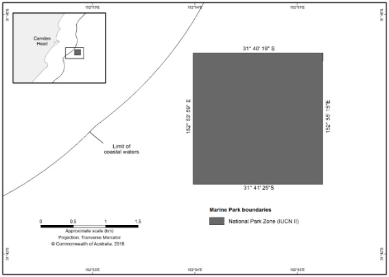
SCHEDULE
COD GROUNDS MARINE PARK
All areas that comprise the Park, being all of that area bounded by the line:
(i) commencing at the point of latitude 31° 40′ 19″ S, longitude 152° 53′ 59″ E;
(ii) from there east along the parallel of latitude 31° 40′ 19″ S to its intersection by the meridian of longitude 152° 55′ 15″ E;
(iii) from there south along the meridian of longitude 152° 55′ 15″ E to the parallel of latitude 31° 41′ 25″ S;
(iv) from there west along the parallel of latitude 31° 41′ 25″ S to its intersection by the meridian of longitude 152° 53′ 59″ E; and
(v) from there north along the meridian of longitude 152° 53′ 59″ E to the point of commencement.
Note: Geographic coordinates are expressed in terms of the Geocentric Datum of Australia 1994 (GDA94) as described in the Commonwealth of Australia Gazette GN35 of 6 September 1995.