Proposal to prepare the Great Barrier Reef’s Southern Plan of Management
Pursuant to subsection 39ZB(1) of the Great Barrier Reef Marine Park Act 1975, the Great Barrier Reef Marine Park Authority (Reef Authority) hereby:
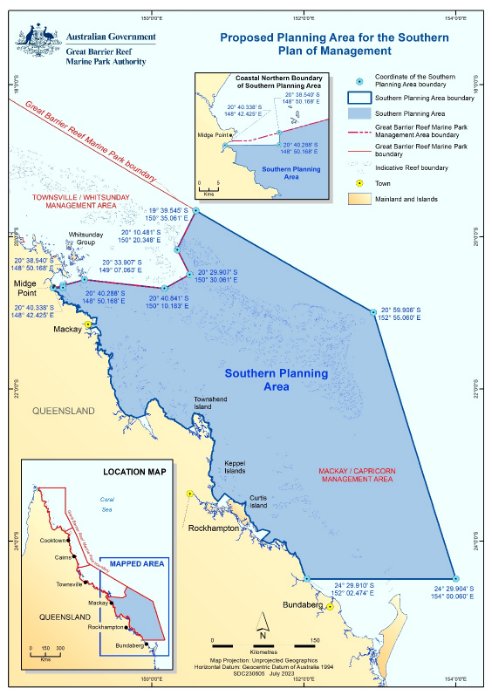
1) states that it proposes to prepare a plan of management for the southern area of the Great Barrier Reef Marine Park, being the area falling within the boundary described in Schedule 1 to this notice (Schedule 1 is a map of the area) and in the dataset titled “Proposed Southern Plan of Management boundary” dated 01 July 2023 available at https://geohub-gbrmpa.hub.arcgis.com/; and
2) invites public comment on or before 19 June 2024 in relation to matters to be included in the plan; and
3) specifies that comments must be sent:
- by post to: the Great Barrier Reef Marine Park Authority, Attn.: Assistant Director – Spatial Planning, PO Box 1379, Townsville Queensland 4810; or
- by email to: SouthernPOM@gbrmpa.gov.au; or
- via online survey: https://www2.gbrmpa.gov.au/access/locations/southern-plan-management
Possible change of management (investment warning)
The proposed plan of management for the southern area of the Great Barrier Reef Marine Park may change the way in which the area is managed. This may include, but is not limited to, changes that may impact upon current and future Marine Parks permit holders.
Privacy statement
Please refer to the Reef Authority’s privacy statement at https://www2.gbrmpa.gov.au/access/locations/southern-plan-management for information on how the Reef Authority collects and manages personal information received from public comments.
Schedule 1 – Proposed Planning Area for the Southern Plan of Management
The proposed Planning Area for the Southern Plan of Management corresponds with the majority of the Mackay/Capricorn Management Area except for the north-west boundary as per the map below. In addition to the map below the spatial boundary can also be viewed via the Reef Authority’s Reef Geohub [https://geohub-gbrmpa.hub.arcgis.com/].