Recognition of Representative Aboriginal/Torres Strait Islander Body 2001 (No. 1)
I, John Joseph Herron, Minister for Aboriginal and Torres Strait Islander Affairs, acting under subsection 203AD(1) of the Native Title Act 1993, recognise the Cape York Land Council as the representative Aboriginal/Torres Strait Islander body for the area described in Schedule 1.
I am satisfied that the Cape York Land Council:
(a) will satisfactorily represent persons who hold or may hold native title in the area described in Schedule 1; and
(b) will be able to consult effectively with Aboriginal peoples and Torres Strait Islanders living in that area; and
(c) would be able to perform satisfactorily the functions of a representative body.
This recognition takes effect on 15 January 2001 .
Dated 16 January 2001
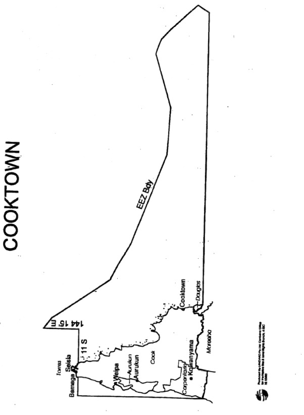
Schedule 1 Description of area (Cooktown)
- The area is the area of land and waters bounded by lines commencing at the
intersection of the centre thread of the Staaten River and the coastline of mainland Australia, and then proceeding due north in a straight line to the intersection with
latitude 11 degrees south, then east along that latitude to its intersection with the
coastline of mainland Australia, then generally north-easterly and south-easterly along
the coastline to its intersection with latitude 11 degrees south on the eastern side of
Cape York, then due east along that latitude to the point latitude 11 degrees south
longitude 144 degrees 15 minutes east, then due north along that meridian to its intersection with the Exclusive Economic Zone of Australia (EEZ), then generally
south-easterly along the eastern boundary of that EEZ to its intersection with the
latitude of the southernmost point of the Mean High Water Mark of Snapper Island,
then due west by that latitude to its intersection with a straight line bearing due north
west to the intersection of the coast of mainland Australia and the centre thread of the Daintree River, then in a straight line due north-west to the aforementioned
intersection, then generally north westerly along the centre thread of that River to its intersection with the centre thread of Adastra Creek, then generally northerly along
the centre thread of that Creek to its intersection with the McDowall Mountain Range, then generally northerly along that Range to its intersection with southern boundary of
the 1991 Local Government Area (LGA) of Cook, then generally westerly along the southern boundary of that LGA to its intersection with the eastern boundary of Carpentaria LGA, then generally southerly along the eastern boundary of that LGA to
its intersection with the centre thread of the Staaten River, then generally westerly
along the centre thread of that River to the point of commencement.
This area is to include Barn Island and Crab Island and to exclude the towns of Seisia
and Bamaga.
2. In this Schedule:
exclusive economic zone means the exclusive economic zone within the meaning of
the Seas and Submerged Lands Act 1973.
