
Great Barrier Reef Marine Park Zoning Plan 2003
I, DAVID ALISTAIR KEMP, Minister for the Environment and Heritage, accept this Zoning Plan under subsection 32 (11) of the Great Barrier Reef Marine Park Act 1975.
Dated 2 December 2003
DAVID KEMP
Great Barrier Reef Marine Park Zoning Plan 2003
I, DAVID ALISTAIR KEMP, Minister for the Environment and Heritage, accept this Zoning Plan under subsection 32 (11) of the Great Barrier Reef Marine Park Act 1975.
Dated 2 December 2003
DAVID KEMP
Contents
Preface
A Introduction
B The Amalgamated Great Barrier Reef Section
C The Great Barrier Reef Marine Park Zoning Plan
D Additional management provisions
E Zoning maps
Part 1 Preliminary
1.1 Name of Zoning Plan
1.2 Commencement
1.3 Application of Zoning Plan
1.4 Revocation of previous Zoning Plans
1.5 Interpretation — general
1.6 Interpretation — geographic coordinates etc
1.7 Application of Queensland, Commonwealth and international law
1.8 Lawful taking of animals, plants or marine products
Part 2 Zones
Division 2.1 Zoning of Amalgamated Great Barrier Reef Section
2.1.1 Zoning of Amalgamated Great Barrier Reef Section
Division 2.2 General Use Zone
2.2.1 Location of General Use Zone
2.2.2 Objective for General Use Zone
2.2.3 Use or entry without permission
2.2.4 Use or entry with permission
Division 2.3 Habitat Protection Zone
2.3.1 Location of Habitat Protection Zone
2.3.2 Objectives for Habitat Protection Zone
2.3.3 Use or entry without permission
2.3.4 Use or entry with permission
Division 2.4 Conservation Park Zone
2.4.1 Location of Conservation Park Zone
2.4.2 Objectives for Conservation Park Zone
2.4.3 Use or entry without permission
2.4.4 Use or entry with permission
Division 2.5 Buffer Zone
2.5.1 Location of Buffer Zone
2.5.2 Objectives for Buffer Zone
2.5.3 Use or entry without permission
2.5.4 Use or entry with permission
Division 2.6 Scientific Research Zone
2.6.1 Location of Scientific Research Zone
2.6.2 Objectives for Scientific Research Zone
2.6.3 Use or entry without permission
2.6.4 Use or entry with permission
Division 2.7 Marine National Park Zone
2.7.1 Location of Marine National Park Zone
2.7.2 Objectives for Marine National Park Zone
2.7.3 Use or entry without permission
2.7.4 Use or entry with permission
Division 2.8 Preservation Zone
2.8.1 Location of Preservation Zone
2.8.2 Objective for Preservation Zone
2.8.3 Use or entry without permission
2.8.4 Use or entry with permission
Division 2.9 Commonwealth Islands Zone
2.9.1 Location of Commonwealth Islands Zone
2.9.2 Objectives for Commonwealth Islands Zone
2.9.3 Use or entry without permission
2.9.4 Use or entry with permission
Part 3 Remote Natural Area
3.1 Remote Natural Area
3.2 Objectives for Remote Natural Area
3.3 Use or entry for certain purposes not authorised
3.4 Use or entry with permission
Part 4 Designated Areas
Division 4.1 Shipping Areas
4.1.1 Shipping Areas
4.1.2 Objective for Shipping Areas
4.1.3 Shipping management provision
Division 4.2 Special Management Areas
4.2.1 Special Management Areas
4.2.2 Objective for Special Management Areas
4.2.3 Special management provisions — general
4.2.4 Special management provision — Princess Charlotte Bay Special Management Area
Division 4.3 Fisheries Experimental Areas
4.3.1 Objective of Fisheries Experimental Areas
4.3.2 Designation of Fisheries Experimental Areas
4.3.3 Special management provisions — Fork Reef (18-083) and unnamed reef (21-139)
4.3.4 Special management provisions — unnamed reef (14-133) and Boulton Reef (20-146)
4.3.5 ‘Sunsetting’ of this Division
Part 5 Additional purposes for use or entry
5.1 Use or entry without permission or notification
5.2 Use or entry without permission after notification
5.3 Entry to zones for purpose of taking protected species etc
5.4 Management activities
Schedule 1 Amalgamated Great Barrier Reef Section — descriptions of Zones and Areas
Dictionary
1. The Great Barrier Reef Marine Park Act 1975 (the Act) provides for the establishment, control, care and development of the Great Barrier Reef Marine Park (the Marine Park). The Great Barrier Reef Marine Park Authority (the Authority) is responsible for the management of the Marine Park.
2. The Great Barrier Reef Marine Park Zoning Plan 2003 is the primary planning instrument for the conservation and management of the Marine Park.
3. In having regard to the objects set out in subsection 32 (7) of the Act, this Zoning Plan takes account of the world heritage values of the Marine Park and the principles of ecologically sustainable development. This Zoning Plan aims, in conjunction with other management mechanisms, to protect and conserve the biodiversity of the Great Barrier Reef ecosystem within a network of highly protected zones, while providing opportunities for the ecologically sustainable use of, and access to, the Great Barrier Reef Region by current and future generations.
4. In addition to the protection of representative areas of biodiversity, this Zoning Plan also provides for the protection of other areas of high conservation value by assigning protective zoning to a range of habitats such as coral reefs, sponge beds, seagrass beds and deep water areas, as well as important dugong habitats and other special or unique sites.
5. The Marine Park is managed as a multiple use area. This means that, while enhancing the conservation of the Marine Park, this Zoning Plan also provides for a range of recreational, commercial and research opportunities, and for the continuation of traditional activities.
6. This Zoning Plan expressly acknowledges the rights and interests of indigenous Australians in the Marine Park by providing for the management of the traditional use of marine resources, including traditional hunting, in accordance with Aboriginal and Torres Strait Islander custom and tradition.
7. The contributions of scientific research to the management and understanding of the Marine Park are also acknowledged in this Zoning Plan, which provides for the management of research in the Marine Park, including a system of Scientific Research Zones to facilitate research around scientific research stations.
8. This Zoning Plan builds on the framework established by previous zoning plans for the Far Northern, Cairns, Central, Mackay/Capricorn and Gumoo Woojabuddee Sections to provide a single, consistent zoning plan for the entire Marine Park. This Zoning Plan also provides zoning for the 28 new coastal areas which have been included in the Marine Park since the year 2000.
9. Many of the provisions of previous zoning plans have been revised and simplified in this Zoning Plan. This Zoning Plan also provides for the description of zone boundaries through a coordinate-based system. It is envisaged that, in addition to the conservation benefits, these changes will provide for a simpler, more consistent, and user-friendly basis for the management of activities within the Marine Park.
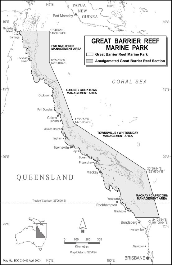
B The Amalgamated Great Barrier Reef Section
10. Since the declaration of the first area (or Section) of the Marine Park in 1983, the Marine Park has been progressively increased to its present area by the addition of new Sections.
11. The Far Northern Section, the Cairns Section, the Central Section and the Mackay/Capricorn Section were progressively declared to be parts of the Marine Park between 1983 and 1989. In 1998 the Gumoo Woojabuddee Section was declared to be a part of the Marine Park, and a further 28 new coastal Sections were declared to be parts of the Marine Park in 2000 and 2001.
12. The Amalgamated Great Barrier Reef Section (the AGBR Section) was proclaimed under subsection 31 (1) of the Act in 2003 (Gazette No. XXX dated XXX).
13. The AGBR Section covers more than 99% of the Great Barrier Reef Region and replaces all previously existing Sections (as listed in Table 1 at the end of this Preface). For administrative purposes, the AGBR Section is divided into 4 management areas:
the Far Northern Management Area
the Cairns/Cooktown Management Area
the Townsville/Whitsunday Management Area
the Mackay/Capricorn Management Area.
Although these management areas have no legislative effect, they approximate the areas of the previous 4 main Sections and provide a basis for the regional management of the Marine Park. Further sub-areas or regions may also be identified for particular management purposes.
14. The following map shows the location and extent of the AGBR Section.
C The Great Barrier Reef Marine Park Zoning Plan
15. The framework for the conservation and management of the AGBR Section is provided by this Zoning Plan, the requirements for the preparation of which are set out in section 32 of the Act.
16. Subsection 32 (7) of the Act provides that, in preparing a zoning plan, the Authority must have regard to a number of objects including the conservation of the Great Barrier Reef, the regulation of the use of the Marine Park so as to protect the Great Barrier Reef, the reservation of some areas for appreciation and enjoyment by the public, and the preservation of some areas in their natural state.
17. This Zoning Plan provides for the division of the AGBR Section into zones and makes provision for the purposes for which each zone may be used or entered. This Zoning Plan also provides for the management of remote natural areas of the Marine Park, and the designation of shipping and special management areas, as well as additional purposes for which zones may be used or entered.
Zones
18. Part 2 of this Zoning Plan divides the AGBR Section into 8 zones, named as follows:
General Use Zone
Habitat Protection Zone
Conservation Park Zone
Buffer Zone
Scientific Research Zone
Marine National Park Zone
Preservation Zone
Commonwealth Islands Zone.
19. The boundaries of the zones are set out in Parts 1 to 8 of Schedule 1 to this Zoning Plan.
20. This Zoning Plan sets out the purposes for which each zone may be used or entered without permission, and the purposes for which each zone may be used or entered only with the written permission of the Authority. The General Use Zone provides for the widest range of activities, while the Preservation Zone is the most restricted. The Commonwealth Islands Zone provides for the use or entry of areas of the Marine Park above mean low water on Commonwealth Islands. (The Marine Park does not include areas that form a part of Queensland.)
21. The operation of Part 2 (Zones) is subject to the provisions of Part 3 (Remote Natural Area), Part 4 (Designated Areas) and Part 5 (Additional purposes for use or entry), which are discussed below. The overlay of use or entry provisions within the zoned areas, as provided by or under Parts 3, 4 and 5, is an integral part of the zoning scheme.
Remote Natural Area
22. Part 3 (Remote Natural Area) of this Zoning Plan provides for the establishment of the Remote Natural Area to ensure that the Area is recognised and managed for its natural and undeveloped character. The provisions of this Zoning Plan for the Remote Natural Area are primarily concerned with recreational and tourism use or amenity, and are intended to encourage recognition of the value of the area as remote destinations for low levels of nature-based tourism and private recreation. The Remote Natural Area is also intended to be largely free from structures and permanently moored facilities, and to restrict certain works such as dredging and spoil disposal.
23. The boundary of the Remote Natural Area established at the commencement of this Zoning Plan is set out in Part 9 of Schedule 1 to this Zoning Plan. The approximate location of the Remote Natural Area is shown on relevant zoning maps accompanying this Zoning Plan. Regulations made under the Act may from time to time designate further zoned areas as part of the Remote Natural Area.
Designated Areas
24. Part 4 (Designated Areas) of this Zoning Plan provides for 3 kinds of Designated Areas within zoned areas.
25. Shipping Areas are intended to facilitate passage through the Marine Park by ships. A Shipping Area is an area within which ships may navigate through the Marine Park, subject to any limitations prescribed in the Regulations. The Shipping Areas designated at the commencement of this Zoning Plan are described in Part 10 of Schedule 1 to this Zoning Plan. Further Shipping Areas may be designated in the Regulations.
26. Special Management Areas are parts of the zoned areas where specific management measures are necessary — for example, to regulate access or activities in heavily used areas, to protect resources, to allow for the replenishment of resource stocks, or to ensure public safety. The Special Management Areas may be applied on a temporary, seasonal or permanent basis as prescribed in the Regulations. The Authority may also designate Special Management Areas in accordance with the Regulations to deal with situations requiring immediate management action.
27. Fisheries Experimental Areas provide for the continuation of scientific research into the effects of line fishing on the fish stocks and ecosystems of the Great Barrier Reef through the Effects of Line Fishing Experiment, which is being conducted by the Cooperative Research Centre for the Great Barrier Reef World Heritage Area. The Experiment commenced in 1995 and is due to be completed in 2005, after which the Fisheries Experimental Areas will revert to their underlying zoning. The Fisheries Experimental Areas are described in Part 11 of Schedule 1 to this Zoning Plan.
Additional purposes for use or entry
28. Part 5 (Additional purposes for use or entry) of this Zoning Plan provides for use or entry to zones for purposes in addition to those for which provision is made in Part 2 (Zones), Part 3 (Remote Natural Area) and Part 4 (Designated Areas). Such purposes include access for the purposes of safety, emergencies, environmental monitoring, navigational aids, defence operations, government survey, and Aboriginal or Torres Strait Islander custom or tradition.
Enforcement of this Zoning Plan
29. The provisions of this Zoning Plan are enforced by sections 38A to 38E of the Act (which set out offences relating to use or entry of a zone for purposes that are not permitted, or in contravention of permission requirements or conditions) and sections 38M to 38MB of the Act (which set out offences relating to the use of ships). Contravening notification requirements or directions of the Authority is also an offence.
D Additional management provisions
30. In addition to this Zoning Plan, regard should be had to the Great Barrier Reef Marine Park Act 1975, the Regulations, and any plans of management or policies of the Authority in force from time to time. Additional restrictions or requirements may also apply with respect to a particular use or entry of a place or conduct of an activity under another law of the Commonwealth or under a Queensland law.
Plans of management
31. Under Part VB of the Act, the Authority may prepare plans of management, that are more detailed than this Zoning Plan, to provide for the management of natural and cultural heritage values, the use of particular areas of the Marine Park, or the conservation of species or ecological communities within the Marine Park.
32. Under Part VB of the Act, the Authority may enter into an agreement or arrangement with a community group (including an Aboriginal or Torres Strait Islander group) that has a special interest in an area of the Marine Park. The agreement or arrangement may relate to the development or implementation, or both, of a plan of management and may provide that the community group is to manage the area (or a species or an ecological community within the area) jointly with the Authority in accordance with the plan of management.
Regulations
33. The Great Barrier Reef Marine Park Regulations 1983 are made under section 66 of the Act. Among other things, the Regulations give effect to aspects of this Zoning Plan. They provide for a range of matters, including the conduct of activities in a zone or a part of a zone. They also provide for the designation of areas and for the process of obtaining permissions required for the use or entry of zones under this Zoning Plan.
Other provisions of the Act
34. The Great Barrier Reef Marine Park Act 1975 also provides that:
no operations for the recovery of minerals may be carried on in the Marine Park, except where such operations are carried out with the approval of the Authority under subsection 38 (3) of the Act for the purposes of research and investigations relevant to the establishment, care and development of the Marine Park or for scientific research;
waste may not be discharged into the Marine Park other than in accordance with section 38J of the Act and subject to the provisions of the Regulations;
a scheme of compulsory pilotage is imposed on regulated ships in the compulsory pilotage area (that part of the Great Barrier Reef Region prescribed by the Regulations);
an Environmental Management Charge is imposed on chargeable permissions;
the provisions of the Act apply to all persons, including foreigners, and to all vessels and aircraft, including foreign vessels and aircraft, whether or not they are within the limits of Australia and the Australian coastal sea, subject to the obligations of Australia under international law, including obligations under any agreement between Australia and another country or countries.
35. A zoning map shows the general location of zones. From time to time the Authority may produce zoning maps and other map-based products, including guides to zoning at various scales, to illustrate and interpret this Zoning Plan for ease of understanding and for education. Although these products may display zoning to a high degree of mapping accuracy, they have no legal effect and are not a substitute for the zone boundary descriptions provided in Schedule 1 to this Zoning Plan.
36. Schedule 1 sets out the definitive boundaries for the zones and other areas described in this Zoning Plan. Each zoned location has a unique identifier (for example, MNP–11–031). This identifier is used in Schedule 1 where each zone is described, and allows zoned locations to be identified on zoning maps.
37. The boundaries of the Remote Natural Area and some Designated Areas are described in Schedule 1. However, after this Zoning Plan commences, further areas may be designated in accordance with the Regulations. Descriptions of the Remote Natural Area or Designated Areas designated after the commencement of this Zoning Plan will be published on the Authority’s web-site (http://www.gbrmpa.gov.au).
Table 1 — Sections of the Marine Park replaced by the AGBR Section
(Preface, paragraph 13)
Name of Section | Date of gazettal | Gazette No. |
Far Northern Section | 31 August 1983 | S 195 |
Cairns Section | 13 September 1989 | GN 35 |
Central Section | 15 October 1984 | S 409 |
Mackay/Capricorn Section | 24 September 1987 | S 247 |
Gumoo Woojabuddee Section | 14 January 1998 | GN 2 |
Shadwell Section | 2 August 2000 | GN 30 |
Heathlands Section | 2 August 2000 | GN 30 |
Margaret Bay Section | 2 August 2000 | GN 30 |
Indian Bay Section | 2 August 2000 | GN 30 |
Fair Cape Section | 2 August 2000 | GN 30 |
Weymouth Section | 13 December 2000 | GN 49 |
Night Island Section | 2 August 2000 | GN 30 |
Claremont Section | 2 August 2000 | GN 30 |
Bathurst Head Section | 13 December 2000 | GN 49 |
Ninian Bay Section | 2 August 2000 | GN 30 |
Cape Flattery Section | 4 July 2001 | GN 26 |
Cooktown Section | 22 December 2000 | S 671 |
Wet Tropics Coast Section | 4 July 2001 | GN 26 |
Clump Point Section | 22 December 2000 | S 671 |
Mission Beach Section | 2 August 2000 | GN 30 |
Halifax Bay Section | 4 July 2001 | GN 26 |
Cleveland Bay Section | 4 July 2001 | GN 26 |
Burdekin Section | 2 August 2000 | GN 30 |
Edgecumbe Section | 4 July 2001 | GN 26 |
Airlie Beach Section* | 4 July 2001 | GN 26 |
Repulse Bay Section | 2 August 2000 | GN 30 |
Sandringham Section* | 4 July 2001 | GN 26 |
Broad Sound Section | 22 December 2000 | S 671 |
Farnborough Section | 4 July 2001 | GN 26 |
Keppel Bay Section | 4 July 2001 | GN 26 |
Curtis Island Section | 22 December 2000 | S 671 |
Boyne Section | 4 July 2001 | GN 26 |
Bustard Bay Section | 2 August 2000 | GN 30 |
* Amended by the Great Barrier Reef Marine Park (Declared Areas) Amendment | ||
Great Barrier Reef Marine Park Zoning Plan 2003
The Great Barrier Reef Marine Park Authority has prepared this Zoning Plan under section 32 of the Great Barrier Reef Marine Park Act 1975.
Dated 26 November 2003
This Zoning Plan is the Great Barrier Reef Marine Park Zoning Plan 2003.
This Zoning Plan comes into operation on the date specified in a notice published in the Gazette under subsection 33 (5) of the Act.
1.3 Application of Zoning Plan
This Zoning Plan applies to the Amalgamated Great Barrier Reef Section of the Marine Park.
Note The Amalgamated Great Barrier Reef Section is defined in the Regulations — see the Dictionary.
1.4 Revocation of previous Zoning Plans
The following Zoning Plans, as amended and in force immediately before the commencement of this Zoning Plan, are revoked:
(a) the Central Section Zoning Plan that came into operation on 1 October 1987;
(b) the Mackay/Capricorn Section Zoning Plan that came into operation on 1 August 1988;
(c) the Cairns Section Zoning Plan that came into operation on 3 April 1992;
(d) the Far Northern Section Zoning Plan that came into operation on 15 April 2002;
(e) the Gumoo Woojabuddee Section Zoning Plan that came into operation on 20 December 2002.
(1) The dictionary at the end of this Zoning Plan defines particular words and expressions, and, for that purpose, includes references to certain words and expressions that are defined in the Act or Regulations, or in other legislation.
(2) Unless the contrary intention appears, a definition in or applying to this Zoning Plan applies to each use of the word or expression in this Zoning Plan.
(3) A reference in a definition in the Dictionary to a limitation prescribed in the Regulations includes a condition or limitation by or in terms of any of the following:
(a) apparatus or method used;
(b) place;
(c) season, or time of year;
(d) in relation to fish or marine animals taken — species, size, number, condition, sex, or maturity;
(e) in relation to plants taken — species, size, number, condition, sex, or maturity;
(f) in relation to marine product taken — kind or quantity;
(g) any other matter.
(4) An example in this Zoning Plan is not part of this Zoning Plan.
(5) If this Zoning Plan includes an example of the operation of a provision of the Plan:
(a) the example is not exhaustive; and
(b) if the example is inconsistent with the provision, the provision prevails.
(6) Headings of Parts, Divisions and sections in this Zoning Plan are part of this Zoning Plan.
(7) A note in this Zoning Plan is explanatory and is not part of this Zoning Plan.
(8) The Preface to this Zoning Plan is explanatory and is not part of this Zoning Plan.
(9) A zoning map that accompanies this Zoning Plan is indicative only and is not part of this Zoning Plan.
1.6 Interpretation — geographic coordinates etc
(1) In this Zoning Plan, all references to geographic coordinates are expressed in terms of the Geocentric Datum of Australia 1994.
Note The Geocentric Datum of Australia 1994 (also known as GDA 94) was published in Gazette No. GN 35 of 6 September 1995.
(2) Unless otherwise specified in this Zoning Plan, a boundary is taken to follow the geodesic between 2 coordinates.
(3) For this Zoning Plan, if the boundary descriptions of 2 zones described in Schedule 1 partly or completely overlap, the area of overlap is taken to be part of the highest applicable zone specified in the following list:
(a) Preservation Zone;
(b) Scientific Research Zone;
(c) Marine National Park Zone;
(d) Buffer Zone;
(e) Conservation Park Zone;
(f) Habitat Protection Zone;
(g) General Use Zone.
(4) For subsection (3):
(a) the highest applicable zone is specified by paragraph (3) (a); and
(b) successively lower applicable zones are specified by paragraphs (3) (b) to (f); and
(c) the lowest applicable zone is specified by paragraph (3) (g).
(5) An area that is part of the Commonwealth Islands Zone is not part of any other zone.
Examples for subsections (3), (4) and (5)
1. The boundary of the Habitat Protection Zone described in Part 2 of Schedule 1 does not include any area within that boundary that is described in Part 3 (Conservation Park Zone), Part 4 (Buffer Zone), Part 5 (Scientific Research Zone), Part 6 (Marine National Park Zone), Part 7 (Preservation Zone) or Part 8 (Commonwealth Islands Zone) of Schedule 1.
2. An area that is within the boundary description of the Marine National Park Zone and also within the boundary description of the Habitat Protection Zone is zoned as part of the Marine National Park Zone (because the Habitat Protection Zone is a lower applicable zone than the Marine National Park Zone).
Note for subsections (3), (4) and (5) Zones described in Schedule 1 are described with reference to their outermost boundary and do not include areas of other zones that may fall within that boundary description — see the examples below and the notes to Parts 1 to 8 of Schedule 1.
(6) Each zoned location described in Schedule 1 to this Zoning Plan is given a unique identifier and a location description.
Example for subsection (6)
The area of the Marine National Park Zone that forms a cross-shelf transect in northern Cape York and includes the Great Detached Reef (11–244) is described in Part 6 of Schedule 1 and is given the unique identifier MNP–11–1004.
(7) In this Zoning Plan, a reference to the 100 metre, 500 metre or 1 kilometre line is a reference to a notional line every point on which is 100 metres, 500 metres or 1 kilometre, as the case may be, seaward from the nearest point of the reef edge to which the line relates.
(8) In this Zoning Plan, a reference to the coastal 100 metre, 500 metre or 1 kilometre line is a reference to a notional line every point on which is:
(a) 100 metres, 500 metres or 1 kilometre, as the case may be, seaward from the nearest point of the land at low water to which the line relates; or
(b) if a fringing reef is adjacent to the land — 100 metres, 500 metres or 1 kilometre, as the case may be, seaward from the nearest point of the reef edge to which the line relates.
(9) In this Zoning Plan, a reference to the 5 kilometre line is a reference to a notional line every point on which is 5 kilometres seaward from the nearest point of the land at low water to which the line relates.
1.7 Application of Queensland, Commonwealth and international law
(1) This Zoning Plan does not apply to an island, or a part of an island, that forms part of Queensland and is not owned by the Commonwealth.
(2) This Zoning Plan does not authorise an act or omission that would, apart from the plan, contravene:
(a) the Act, the Regulations or a plan of management; or
(b) any other law of the Commonwealth or Queensland in force in the Amalgamated Great Barrier Reef Section; or
(c) an obligation of Australia under international law.
(3) Nothing in this Zoning Plan is intended to extinguish any native title rights and interests.
(4) Nothing in this Zoning Plan is intended to affect the operation of section 211 of the Native Title Act 1993 in relation to any provision of this Zoning Plan.
1.8 Lawful taking of animals, plants or marine products
A reference in this Zoning Plan to the use of a vessel, or a net, hand-held implement or other apparatus, for the taking of animals, plants or marine products, is a reference to the lawful use of that vessel, net, hand-held implement or apparatus in accordance with Queensland fisheries legislation.
Note The Act includes the following provisions relating to zones, and imposes penalties for breaches of the provisions:
(a) a person must not use or enter a zone for a purpose that is not permitted under a Zoning Plan — Act, section 38A;
(b) if, under this Zoning Plan, permission is needed to use or enter a zone for a particular purpose, a person must not use or enter the zone for that purpose without permission — Act, section 38B;
(c) a person who has permission to use or enter a zone for a particular purpose must not contravene a condition of that permission — Act, section 38C;
(d) a person must not use or enter a zone for fishing of a kind that is not permitted under a Zoning Plan — Act, section 38CA;
(e) if permission is needed for fishing in a particular zone, a person must not use or enter that zone for fishing without permission — Act, section 38CB;
(f) a person who has permission to use or enter a zone for fishing must not contravene a condition of that permission — Act, section 38CC;
(g) a person is guilty of an offence if the person operates a ship and the ship is in a zone that it is not permitted to be in under this Zoning Plan — Act, section 38M;
(h) if permission is needed for a ship to be in a zone, the person operating the ship is guilty of an offence if the ship is in the zone without permission — Act, section 38MA;
(i) if a permission has been given to a person to operate a ship in a zone, the person must not contravene a condition of that permission — Act, section 38MB.
Division 2.1 Zoning of Amalgamated Great Barrier Reef Section
2.1.1 Zoning of Amalgamated Great Barrier Reef Section
For the purposes of the Act, the Amalgamated Great Barrier Reef Section is divided into the zones described in Schedule 1 and named as follows:
(a) the General Use Zone;
(b) the Habitat Protection Zone;
(c) the Conservation Park Zone;
(d) the Buffer Zone;
(e) the Scientific Research Zone;
(f) the Marine National Park Zone;
(g) the Preservation Zone;
(h) the Commonwealth Islands Zone.
2.2.1 Location of General Use Zone
The General Use Zone consists of the areas described in Part 1 of Schedule 1.
Note The General Use Zone is indicated by light blue shading on zoning maps.
2.2.2 Objective for General Use Zone
The objective of this Zoning Plan for the General Use Zone is to provide for the conservation of areas of the Marine Park, while providing opportunities for reasonable use.
2.2.3 Use or entry without permission
Note If a provision of this Zoning Plan has the effect that an activity in an area requires permission, and another provision of the plan would have the effect that the same activity in that area does not require permission, the provision to the effect that the activity requires permission prevails — see subsection 3A (2) of the Act.
Subject to Part 3 (Remote Natural Area) and Part 4 (Designated Areas), the General Use Zone may be used or entered without permission for any of the following purposes:
(a) low impact activities, including low impact recreational activities, that do not involve the taking of plants, animals or marine products;
(b) fishing or collecting involving:
(i) trawling; or
(ii) trolling; or
(iii) line fishing; or
(iv) limited spearfishing; or
(v) netting (including bait netting); or
(vi) trapping; or
(vii) taking in accordance with an accredited harvest fishery; or
(viii) limited collecting;
(c) traditional use of marine resources involving an activity otherwise permitted under this section or in accordance with:
(i) an accredited traditional use of marine resources agreement; and
(ii) any requirements relating to the operation of that agreement prescribed in the Regulations;
(d) photography, filming or sound recording;
(e) limited impact research (extractive) or limited impact research (non‑extractive);
(f) conducting a limited educational program;
(g) navigating a vessel or aircraft (except a managed vessel or aircraft) if any equipment that is normally used for fishing or collecting is stowed or secured when the vessel or aircraft is in a part of the zone in which the use of the equipment is not permitted.
2.2.4 Use or entry with permission
Note 1 See note to section 2.2.3.
Note 2 The Regulations deal with obtaining permissions.
Subject to Part 3 (Remote Natural Area), Part 4 (Designated Areas) and Part 5 (Additional purposes for use or entry), the written permission of the Authority is required to use or enter the General Use Zone for any of the following purposes:
(a) fishing involving:
(i) taking in a harvest fishery other than an accredited harvest fishery; or
(ii) conducting a developmental fishery program;
(b) collecting other than that permitted by section 2.2.3;
(c) traditional use of marine resources that is not permitted by paragraph 2.2.3 (c);
Example for paragraph (c)
Traditional use of marine resources that involves fishing of a kind mentioned in section 2.2.3 (for example, trolling, line fishing or bait netting) would not require permission under this section.
(d) conducting an aquaculture operation;
(e) operating a fishing industry service vessel;
(f) conducting a tourist program;
(g) research, other than limited impact research (extractive) or limited impact research (non-extractive);
(h) conducting an educational program, other than a limited educational program;
(i) conducting a vessel or aircraft charter operation;
(j) operating a vessel or aircraft in 1 vicinity:
(i) for more than 14 consecutive days; or
(ii) for more than 30 days in any period of 60 days;
(k) navigating a managed vessel or aircraft;
(l) operating a facility for a purpose that is consistent with the objective mentioned in section 2.2.2 for the zone (other than the use of a vessel or aircraft for a purpose mentioned in section 2.2.3), including:
(i) discharging waste from the facility; or
(ii) building, assembling, fixing in position, maintaining or demolishing the facility; or
(iii) constructing or operating mooring facilities for vessels or aircraft; or
(iv) operating a landing area or facility for aircraft;
(m) carrying out works for a purpose that is consistent with the objective mentioned in section 2.2.2 for the zone, including:
(i) dredging; or
(ii) dumping of spoil; or
(iii) reclamation; or
(iv) beach protection works; or
(v) harbour works;
(n) a program to take animals or plants that pose a threat to:
(i) human life or safety; or
(ii) marine ecosystems of the Marine Park; or
(iii) the use or amenity of a part of the zone or an adjacent area;
not being a taking of animals or plants for which, under section 2.2.3 or Part 5 (Additional purposes for use or entry), permission is not required;
(o) any other purpose that is consistent with the objective mentioned in section 2.2.2 for the zone and is not mentioned in section 2.2.3, other than an activity declared for the purposes of this paragraph in the Regulations.
Division 2.3 Habitat Protection Zone
2.3.1 Location of Habitat Protection Zone
The Habitat Protection Zone consists of the areas described in Part 2 of Schedule 1.
Note The Habitat Protection Zone is indicated by dark blue shading on zoning maps.
2.3.2 Objectives for Habitat Protection Zone
The objectives of this Zoning Plan for the Habitat Protection Zone are:
(a) to provide for the conservation of areas of the Marine Park through the protection and management of sensitive habitats, generally free from potentially damaging activities; and
(b) subject to the objective mentioned in paragraph (a), to provide opportunities for reasonable use.
2.3.3 Use or entry without permission
Note If a provision of this Zoning Plan has the effect that an activity in an area requires permission, and another provision of the plan would have the effect that the same activity in that area does not require permission, the provision to the effect that the activity requires permission prevails — see subsection 3A (2) of the Act.
Subject to Part 3 (Remote Natural Area) and Part 4 (Designated Areas), the Habitat Protection Zone may be used or entered without permission for any of the following purposes:
(a) low impact activities, including low impact recreational activities, that do not involve the taking of plants, animals or marine products;
(b) fishing or collecting involving:
(i) trolling; or
(ii) line fishing; or
(iii) limited spearfishing; or
(iv) netting (including bait netting); or
(v) trapping; or
(vi) taking in accordance with an accredited harvest fishery; or
(vii) limited collecting;
(c) traditional use of marine resources involving an activity otherwise permitted under this section or in accordance with:
(i) an accredited traditional use of marine resources agreement; and
(ii) any requirements relating to the operation of that agreement prescribed in the Regulations;
(d) photography, filming or sound recording;
(e) limited impact research (extractive) or limited impact research (non‑extractive);
(f) conducting a limited educational program;
(g) navigating a vessel or aircraft (except a ship or a managed vessel or aircraft), if any equipment that is normally used for fishing or collecting is stowed or secured when the vessel or aircraft is in a part of the zone in which the use of the equipment is not permitted.
2.3.4 Use or entry with permission
Note 1 See note to section 2.3.3.
Note 2 The Regulations deal with obtaining permissions.
Subject to Part 3 (Remote Natural Area), Part 4 (Designated Areas) and Part 5 (Additional purposes for use or entry), the written permission of the Authority is required to use or enter the Habitat Protection Zone for any of the following purposes:
(a) fishing involving:
(i) taking in a harvest fishery other than an accredited harvest fishery; or
(ii) conducting a developmental fishery program; or
(iii) taking of leader prawn broodstock in the Mission Beach Leader Prawn Broodstock Capture Area, in accordance with any limitations prescribed in the Regulations;
(b) collecting other than that permitted by section 2.3.3;
(c) traditional use of marine resources that is not permitted by paragraph 2.3.3 (c);
(d) conducting an aquaculture operation that does not include the addition of feed;
(e) operating a fishing industry service vessel;
(f) conducting a tourist program;
(g) research, other than limited impact research (extractive) or limited impact research (non-extractive);
(h) conducting an educational program, other than a limited educational program;
(i) conducting a vessel or aircraft charter operation;
(j) operating a vessel or aircraft in 1 vicinity:
(i) for more than 14 consecutive days; or
(ii) for more than 30 days in any period of 60 days;
(k) navigating a ship, or a managed vessel or aircraft;
(l) operating a facility for a purpose that is consistent with the objective mentioned in section 2.3.2 for the zone (other than the use of a vessel or aircraft for a purpose mentioned in section 2.3.3), including:
(i) discharging waste from the facility; or
(ii) building, assembling, fixing in position, maintaining or demolishing the facility; or
(iii) constructing or operating mooring facilities for vessels or aircraft; or
(iv) operating a landing area or facility for aircraft;
(m) carrying out works for a purpose that is consistent with the objective mentioned in section 2.3.2 for the zone, including:
(i) dredging; or
(ii) dumping of spoil; or
(iii) reclamation; or
(iv) beach protection works; or
(v) harbour works;
(n) a program to take animals or plants that pose a threat to:
(i) human life or safety; or
(ii) marine ecosystems in the Marine Park; or
(iii) the use or amenity of a part of the zone or an adjacent area;
not being a taking of animals or plants for which, under section 2.3.3 or Part 5 (Additional purposes for use or entry), permission is not required;
(o) any other purpose that is consistent with the objective mentioned in section 2.3.2 for the zone and is not mentioned in section 2.3.3, other than an activity declared for the purposes of this paragraph in the Regulations.
Division 2.4 Conservation Park Zone
2.4.1 Location of Conservation Park Zone
The Conservation Park Zone consists of the areas described in Part 3 of Schedule 1.
Note The Conservation Park Zone is indicated by yellow shading on zoning maps.
2.4.2 Objectives for Conservation Park Zone
The objectives of this Zoning Plan for the Conservation Park Zone are:
(a) to provide for the conservation of areas of the Marine Park; and
(b) subject to the objective mentioned in paragraph (a), to provide opportunities for reasonable use and enjoyment, including limited extractive use.
2.4.3 Use or entry without permission
Note If a provision of this Zoning Plan has the effect that an activity in an area requires permission, and another provision of the plan would have the effect that the same activity in that area does not require permission, the provision to the effect that the activity requires permission prevails — see subsection 3A (2) of the Act.
Subject to Part 3 (Remote Natural Area) and Part 4 (Designated Areas), the Conservation Park Zone may be used or entered without permission for any of the following purposes:
(a) low impact activities, including low impact recreational activities, that do not involve the taking of plants, animals or marine products;
(b) fishing or collecting involving:
(i) trolling; or
(ii) limited line fishing; or
(iii) limited spearfishing; or
(iv) bait netting; or
(v) limited trapping; or
(vi) limited collecting;
(vii) taking in accordance with any of the following fisheries that is an accredited harvest fishery:
(A) the Aquarium Fish Fishery;
(B) the Coral Fishery;
(C) the Worm Fishery (Beachworm);
(c) traditional use of marine resources involving an activity otherwise permitted under this section or in accordance with:
(i) an accredited traditional use of marine resources agreement; and
(ii) any requirements relating to the operation of that agreement prescribed in the Regulations;
(d) photography, filming or sound recording;
(e) limited impact research (extractive) or limited impact research (non‑extractive);
(f) conducting a limited educational program;
(g) navigating a vessel or aircraft (except a ship or a managed vessel or aircraft) if any equipment that is normally used for fishing or collecting is stowed or secured when the vessel or aircraft is in a part of the zone in which the use of the equipment is not permitted.
2.4.4 Use or entry with permission
Note 1 See note to section 2.4.3.
Note 2 The Regulations deal with obtaining permissions.
Subject to Part 3 (Remote Natural Area), Part 4 (Designated Areas) and Part 5 (Additional purposes for use or entry), the written permission of the Authority is required to use or enter the Conservation Park Zone for any of the following purposes:
(a) traditional use of marine resources that is not permitted by paragraph 2.4.3 (c);
(b) taking in accordance with any of the following fisheries that is not an accredited harvest fishery:
(i) the Aquarium Fish Fishery;
(ii) the Coral Fishery;
(iii) the Worm Fishery (Beachworm);
(c) conducting an aquaculture operation that does not include the addition of feed;
(d) operating a fishing industry service vessel;
(e) conducting a tourist program;
(f) research, other than limited impact research (extractive) or limited impact research (non-extractive);
(g) conducting an educational program, other than a limited educational program;
(h) conducting a vessel or aircraft charter operation;
(i) operating a vessel or aircraft in 1 vicinity:
(i) for more than 14 consecutive days; or
(ii) for more than 30 days in any period of 60 days;
(j) navigating a ship, or a managed vessel or aircraft;
(k) operating a facility for a purpose that is consistent with the objective mentioned in section 2.4.2 for the zone (other than the use of a vessel or aircraft for a purpose mentioned in section 2.4.3), including:
(i) discharging waste from the facility; or
(ii) building, assembling, fixing in position, maintaining or demolishing the facility; or
(iii) constructing or operating mooring facilities for vessels or aircraft; or
(iv) operating a landing area or facility for aircraft;
(l) carrying out works for a purpose that is consistent with the objective mentioned in section 2.4.2 for the zone;
(m) a program to take animals or plants that pose a threat to:
(i) human life or safety; or
(ii) marine ecosystems in the Marine Park; or
(iii) the use or amenity of a part of the zone or an adjacent area;
not being a taking of animals or plants for which, under section 2.4.3 or Part 5 (Additional purposes for use or entry), permission is not required;
(n) any other purpose that is consistent with the objective mentioned in section 2.4.2 for the zone and is not mentioned in section 2.4.3, other than an activity declared for the purposes of this paragraph in the Regulations.
The Buffer Zone consists of the areas described in Part 4 of Schedule 1.
Note The Buffer Zone is indicated by olive green shading on zoning maps.
2.5.2 Objectives for Buffer Zone
The objectives of this Zoning Plan for the Buffer Zone are:
(a) to provide for the protection of the natural integrity and values of areas of the Marine Park, generally free from extractive activities; and
(b) subject to the objective mentioned in paragraph (a), to provide opportunities for:
(i) certain activities, including the presentation of the values of the Marine Park, to be undertaken in relatively undisturbed areas; and
(ii) trolling for pelagic species.
2.5.3 Use or entry without permission
Note If a provision of this Zoning Plan has the effect that an activity in an area requires permission, and another provision of the plan would have the effect that the same activity in that area does not require permission, the provision to the effect that the activity requires permission prevails — see subsection 3A (2) of the Act.
Subject to Part 3 (Remote Natural Area) and Part 4 (Designated Areas), the Buffer Zone may be used or entered without permission for any of the following purposes:
(a) low impact activities, including low impact recreational activities, that do not involve the taking of plants, animals or marine products;
(b) fishing involving the taking of pelagic species by trolling;
(c) traditional use of marine resources involving an activity otherwise permitted under this section or in accordance with:
(i) an accredited traditional use of marine resources agreement; and
(ii) any requirements relating to the operation of that agreement prescribed in the Regulations;
(d) photography, filming or sound recording;
(e) limited impact research (non-extractive);
(f) conducting a limited educational program;
(g) navigating a vessel or aircraft (except a ship or a managed vessel or aircraft), if any equipment that is normally used for fishing or collecting is stowed or secured when the vessel or aircraft is in a part of the zone in which the use of the equipment is not permitted.
2.5.4 Use or entry with permission
Note 1 See note to section 2.5.3.
Note 2 The Regulations deal with obtaining permissions.
Subject to Part 3 (Remote Natural Area), Part 4 (Designated Areas) and Part 5 (Additional purposes for use or entry), the written permission of the Authority is required to use or enter the Buffer Zone for any of the following purposes:
(a) traditional use of marine resources that is not permitted by paragraph 2.5.3 (c);
(b) conducting a tourist program;
(c) research (other than limited impact research (non-extractive)) that:
(i) is relevant to, and a priority for, the management of the Marine Park; or
(ii) cannot reasonably be conducted elsewhere;
(d) conducting an educational program, other than a limited educational program;
(e) conducting a vessel or aircraft charter operation;
(f) operating a vessel or aircraft in 1 vicinity:
(i) for more than 14 consecutive days; or
(ii) for more than 30 days in any period of 60 days;
(g) navigating a ship, or a managed vessel or aircraft;
(h) operating a facility for a purpose that is consistent with the objective mentioned in section 2.5.2 for the zone (other than the use of a vessel or aircraft for a purpose mentioned in section 2.5.3), including:
(i) discharging waste from a facility of that kind; or
(ii) building, assembling, fixing in position, maintaining or demolishing such a facility; or
(iii) constructing or operating mooring facilities for vessels; or
(iv) operating a landing area or facility for aircraft;
(i) carrying out works for a purpose that is consistent with the objective mentioned in section 2.5.2 for the zone;
(j) a program to take animals or plants that pose a threat to:
(i) human life or safety; or
(ii) marine ecosystems of the Marine Park; or
(iii) the use or amenity of a part of the zone or an adjacent area;
not being a taking of animals or plants for which, under section 2.5.3 or Part 5 (Additional purposes for use or entry), permission is not required;
(k) any other purpose that is consistent with the objective mentioned in section 2.5.2 for the zone and is not mentioned in section 2.5.3, other than an activity declared for the purposes of this paragraph in the Regulations.
Division 2.6 Scientific Research Zone
2.6.1 Location of Scientific Research Zone
The Scientific Research Zone consists of the areas described in Part 5 of Schedule 1.
Note The Scientific Research Zone is indicated by orange shading on zoning maps.
2.6.2 Objectives for Scientific Research Zone
The objectives of this Zoning Plan for the Scientific Research Zone are:
(a) to provide for the protection of the natural integrity and values of areas of the Marine Park, generally free from extractive activities; and
(b) subject to the objective mentioned in paragraph (a), to provide opportunities for scientific research to be undertaken in relatively undisturbed areas.
2.6.3 Use or entry without permission
Note If a provision of this Zoning Plan has the effect that an activity in an area requires permission, and another provision of the plan would have the effect that the same activity in that area does not require permission, the provision to the effect that the activity requires permission prevails — see subsection 3A (2) of the Act.
Subject to Part 3 (Remote Natural Area) and Part 4 (Designated Areas), the Scientific Research Zone may be used or entered without permission for any of the following purposes:
(a) low impact activities, including low impact recreational activities, that do not involve the taking of plants, animals or marine products;
(b) traditional use of marine resources involving an activity otherwise permitted under this section or in accordance with:
(i) an accredited traditional use of marine resources agreement; and
(ii) any requirements relating to the operation of that agreement prescribed in the Regulations;
(c) photography, filming or sound recording;
(d) limited impact research (extractive) or limited impact research (non‑extractive), or any other research declared for the purposes of this paragraph in the Regulations;
(e) conducting a limited educational program;
(f) navigating a vessel or aircraft (except a ship or a managed vessel or aircraft) if any equipment that is normally used for fishing or collecting is stowed or secured when the vessel or aircraft is in a part of the zone in which the use of the equipment is not permitted.
2.6.4 Use or entry with permission
Note 1 See note to section 2.6.3.
Note 2 The Regulations deal with obtaining permissions.
Subject to Part 3 (Remote Natural Area), Part 4 (Designated Areas) and Part 5 (Additional purposes for use or entry), the written permission of the Authority is required to use or enter the Scientific Research Zone for any of the following purposes:
(a) research, other than research mentioned in section 2.6.3;
(b) traditional use of marine resources that is not permitted by paragraph 2.6.3 (b);
(c) operating a fishing industry service vessel;
(d) conducting a tourist program;
(e) conducting an educational program, other than a limited educational program;
(f) conducting a vessel or aircraft charter operation;
(g) operating a vessel or aircraft in 1 vicinity:
(i) for more than 14 consecutive days; or
(ii) for more than 30 days in any period of 60 days;
(h) navigating a ship, or a managed vessel or aircraft;
(i) operating a facility for a purpose that is consistent with the objective mentioned in section 2.6.2 for the zone (other than the use of a vessel or aircraft for a purpose mentioned in section 2.6.3), including:
(i) discharging waste from a facility of that kind; or
(ii) building, assembling, fixing in position, maintaining or demolishing such a facility; or
(iii) constructing or operating mooring facilities for vessels; or
(iv) operating a landing area or facility for aircraft;
(j) carrying out works for a purpose that is consistent with the objective mentioned in section 2.6.2 for the zone;
(k) a program to take animals or plants that pose a threat to:
(i) human life or safety; or
(ii) marine ecosystems of the Marine Park; or
(iii) the use or amenity of an area or adjacent area;
not being a taking of animals or plants for which, under section 2.6.3 or Part 5 (Additional purposes for use or entry), permission is not required;
(l) any other purpose that is consistent with the objective mentioned in section 2.6.2 for the zone and is not mentioned in section 2.6.3, other than an activity declared for the purposes of this paragraph in the Regulations.
Division 2.7 Marine National Park Zone
2.7.1 Location of Marine National Park Zone
The Marine National Park Zone consists of the areas described in Part 6 of Schedule 1.
Note The Marine National Park Zone is indicated by dark green shading on zoning maps.
2.7.2 Objectives for Marine National Park Zone
The objectives of this Zoning Plan for the Marine National Park Zone are:
(a) to provide for the protection of the natural integrity and values of areas of the Marine Park, generally free from extractive activities; and
(b) subject to the objective mentioned in paragraph (a), to provide opportunities for certain activities, including the presentation of the values of the Marine Park, to be undertaken in relatively undisturbed areas.
2.7.3 Use or entry without permission
Note If a provision of this Zoning Plan has the effect that an activity in an area requires permission, and another provision of the plan would have the effect that the same activity in that area does not require permission, the provision to the effect that the activity requires permission prevails — see subsection 3A (2) of the Act.
Subject to Part 3 (Remote Natural Area) and Part 4 (Designated Areas), the Marine National Park Zone may be used or entered without permission for any of the following purposes:
(a) low impact activities, including low impact recreational activities, that do not involve the taking of plants, animals or marine products;
(b) traditional use of marine resources involving an activity otherwise permitted under this section or in accordance with:
(i) an accredited traditional use of marine resources agreement; and
(ii) any requirements relating to the operation of that agreement prescribed in the Regulations;
(c) photography, filming or sound recording;
(d) limited impact research (non-extractive);
(e) conducting a limited educational program;
(f) navigating a vessel or aircraft (except a ship or a managed vessel or aircraft) if any equipment that is normally used for fishing or collecting is stowed or secured when the vessel or aircraft is in a part of the zone in which the use of the equipment is not permitted.
2.7.4 Use or entry with permission
Note 1 See note to section 2.7.3.
Note 2 The Regulations deal with obtaining permissions.
Subject to Part 3 (Remote Natural Area), Part 4 (Designated Areas) and Part 5 (Additional purposes for use or entry), the written permission of the Authority is required to use or enter the Marine National Park Zone for any of the following purposes:
(a) traditional use of marine resources that is not permitted by paragraph 2.7.3 (b);
(b) operating a fishing industry service vessel;
(c) conducting a tourist program;
(d) research (other than limited impact research (non-extractive)) that:
(i) is relevant to, and a priority for, the management of the Marine Park; or
(ii) cannot reasonably be conducted elsewhere;
(e) conducting an educational program, other than a limited educational program;
(f) conducting a vessel or aircraft charter operation;
(g) operating a vessel or aircraft in 1 vicinity:
(i) for more than 14 consecutive days; or
(ii) for more than 30 days in any period of 60 days;
(h) navigating a ship, or a managed vessel or aircraft;
(i) operating a facility for a purpose that is consistent with the objective mentioned in section 2.7.2 for the zone (other than the use of a vessel or aircraft for a purpose mentioned in section 2.7.3), including:
(i) discharging waste from a facility of that kind; or
(ii) building, assembling, fixing in position, maintaining or demolishing such a facility; or
(iii) constructing or operating mooring facilities for vessels; or
(iv) operating a landing area or facility for aircraft;
(j) carrying out works for a purpose that is consistent with the objective mentioned in section 2.7.2 for the zone;
(k) a program to take animals or plants that pose a threat to:
(i) human life or safety; or
(ii) marine ecosystems of the Marine Park; or
(iii) the use or amenity of an area or adjacent area;
not being a taking of animals or plants for which, under section 2.7.3 or Part 5 (Additional purposes for use or entry), permission is not required;
(l) any other purpose that is consistent with the objective mentioned in section 2.7.2 for the zone and is not mentioned in section 2.7.3, other than an activity declared for the purposes of this paragraph in the Regulations.
Division 2.8 Preservation Zone
2.8.1 Location of Preservation Zone
The Preservation Zone consists of the areas described in Part 7 of Schedule 1.
Note The Preservation Zone is indicated by pink shading on zoning maps.
2.8.2 Objective for Preservation Zone
The objective of this Zoning Plan for the Preservation Zone is to provide for the preservation of the natural integrity and values of areas of the Marine Park, generally undisturbed by human activities.
2.8.3 Use or entry without permission
Note If a provision of this Zoning Plan has the effect that an activity in an area requires permission, and another provision of the plan would have the effect that the same activity in that area does not require permission, the provision to the effect that the activity requires permission prevails —see subsection 3A (2) of the Act.
Subject to Part 3 (Remote Natural Area) and Part 4 (Designated Areas), the Preservation Zone may be used or entered without permission for any of the following purposes:
(a) operating an aircraft at an altitude of not less than 500 feet above the surface;
(b) navigating a vessel (except a ship or a managed vessel or aircraft), for access to areas that form part of Queensland, if any equipment normally used for fishing or collecting is stowed or secured.
2.8.4 Use or entry with permission
Note 1 See note to section 2.8.3.
Note 2 The Regulations deal with obtaining permissions.
Subject to Part 3 (Remote Natural Area), Part 4 (Designated Areas) and Part 5 (Additional purposes for use or entry), the written permission of the Authority is required to use or enter the Preservation Zone for any of the following purposes:
(a) research, including limited impact research (non-extractive) and limited impact research (extractive), that:
(i) is relevant to, and a priority for, the management of the Marine Park; and
(ii) cannot reasonably be conducted elsewhere;
(b) any other purpose that is consistent with the objective mentioned in section 2.8.2 for the zone and is not mentioned in section 2.8.3, other than an activity declared for the purposes of this paragraph in the Regulations.
Division 2.9 Commonwealth Islands Zone
2.9.1 Location of Commonwealth Islands Zone
The Commonwealth Islands Zone consists of the areas described in Part 8 of Schedule 1.
Note 1 The Commonwealth Islands Zone is that area of the Amalgamated Great Barrier Reef Section that is above the low water mark, other than an island, or a part of an island, that forms part of Queensland and is not owned by the Commonwealth — see section 1.7. The location of the Commonwealth Islands Zone may not be indicated on the zoning maps.
Note 2 An area that is a part of the Commonwealth Islands Zone is not included as a part of another zone — see subsection 1.6 (5).
2.9.2 Objectives for Commonwealth Islands Zone
The objectives of this Zoning Plan for the Commonwealth Islands Zone are:
(a) to provide for the conservation of areas of the Marine Park above the low water mark; and
(b) to provide for use of the zone by the Commonwealth; and
(c) subject to the objective mentioned in paragraph (a), to provide for facilities and uses consistent with the values of the area.
2.9.3 Use or entry without permission
Note If a provision of this Zoning Plan has the effect that an activity in an area requires permission, and another provision of the plan would have the effect that the same activity in that area does not require permission, the provision to the effect that the activity requires permission prevails — see subsection 3A (2) of the Act.
Subject to Part 3 (Remote Natural Area) and Part 4 (Designated Areas), the Commonwealth Islands Zone may be used or entered without permission for any of the following purposes:
(a) low impact activities, including low impact recreational activities, that do not involve the taking of plants, animals or marine products;
(b) traditional use of marine resources involving an activity otherwise permitted under this section or in accordance with:
(i) an accredited traditional use of marine resources agreement; and
(ii) any requirements relating to the operation of that agreement prescribed in the Regulations;
(c) photography, filming or sound recording;
(d) conducting a limited educational program;
(e) navigating a vessel or aircraft (except a managed vessel or aircraft) if any equipment that is normally used for fishing or collecting is stowed or secured when the vessel or aircraft is in a part of the zone in which the use of the equipment is not permitted.
2.9.4 Use or entry with permission
Note 1 See note to section 2.9.3.
Note 2 The Regulations deal with obtaining permissions.
Subject to Part 3 (Remote Natural Area), Part 4 (Designated Areas) and Part 5 (Additional purposes for use or entry), the written permission of the Authority is required to use or enter the Commonwealth Islands Zone for any of the following purposes:
(a) traditional use of marine resources that is not permitted by paragraph 2.9.3 (b);
(b) conducting a tourist program;
(c) camping;
(d) research, including limited impact research (extractive) and limited impact research (non-extractive);
(e) conducting an educational program, other than a limited educational program;
(f) conducting a vessel or aircraft charter operation;
(g) operating an aircraft in 1 vicinity:
(i) for more than 14 consecutive days; or
(ii) for more than 30 days in any period of 60 days;
(h) navigating a managed vessel or aircraft;
(i) operating a facility for a purpose that is consistent with the objective mentioned in section 2.9.2 for the zone (other than the use of a vessel or aircraft for a purpose mentioned in section 2.9.3), including:
(i) discharging waste from a facility of that kind; or
(ii) building, assembling, fixing in position, maintaining or demolishing such a facility; or
(iii) operating a landing area or facility for aircraft;
(j) carrying out works for a purpose that is consistent with the objective mentioned in section 2.9.2 for the zone;
(k) a program to take animals or plants that pose a threat to:
(i) human life or safety; or
(ii) island ecosystems of the Marine Park; or
(iii) the use or amenity of a part of the zone or an adjacent area;
not being a taking of animals or plants for which, under section 2.9.3 or Part 5 (Additional purposes for use or entry), permission is not required;
(l) any other purpose that is consistent with the objective mentioned in section 2.9.2 for the zone and is not mentioned in section 2.9.3, other than an activity declared for the purposes of this paragraph in the Regulations.
Note For a summary of the penalty provisions of the Act relating to the use or entry of the Remote Natural Area, see the note at the beginning of Part 2 (Zones).
The Remote Natural Area consists of the following areas (being all, or a part of, 1 or more zones):
(a) the area described in Part 9 of Schedule 1;
(b) any other area designated by the Regulations as part of the Remote Natural Area.
3.2 Objectives for Remote Natural Area
The objectives of this Zoning Plan for the Remote Natural Area, in addition to the objectives of Part 2 (Zones) that apply to zones and parts of zones within the Remote Natural Area, are:
(a) to ensure that the Area remains in a state that is largely unaltered by works or facilities; and
(b) to provide opportunities for quiet appreciation and enjoyment of the Area.
3.3 Use or entry for certain purposes not authorised
Despite anything in Part 2 (Zones), but subject to Part 4 (Designated Areas) and Part 5 (Additional purposes for use or entry), the following purposes are not purposes for which the Remote Natural Area may be used or entered:
(a) motorised watersports;
(b) any other purpose declared for the purposes of this paragraph in the Regulations.
3.4 Use or entry with permission
Note The Regulations deal with obtaining permissions.
(1) Despite anything in Part 2 (Zones), but subject to Part 4 (Designated Areas) and Part 5 (Additional purposes for use or entry), the written permission of the Authority is required to use or enter the Remote Natural Area for a purpose that is declared for the purposes of this section in the Regulations.
(2) A purpose declared for subsection (1) must be a purpose that is not mentioned in section 3.3.
Note For a summary of penalty provisions of the Act relating to the use or entry of Designated Areas, see the note at the beginning of Part 2 (Zones).
Each of the following areas (being a part or parts of a zone, or of more than 1 zone) is a Shipping Area:
(a) the areas described in Part 10 of Schedule 1;
(b) any other area designated as a Shipping Area in the Regulations.
4.1.2 Objective for Shipping Areas
The objective of this Zoning Plan for Shipping Areas is to make provision for the navigation of ships.
4.1.3 Shipping management provision
Note 1 If a provision of this Zoning Plan has the effect that an activity in an area requires permission, and another provision of the plan would have the effect that the same activity in that area does not require permission, the provision to the effect that the activity requires permission prevails — see subsection 3A (2) of the Act.
Note 2 Subject to any requirements to stow or secure fishing equipment, a ship may navigate in the General Use Zone without the permission of the Authority — see paragraph 2.2.3 (g). Any Shipping Areas that may be designated in the General Use Zone are for advisory purposes and do not, by way of the shipping management provisions, restrict the navigation of ships.
Despite anything in Part 2 (Zones) or Part 3 (Remote Natural Area), but subject to Division 4.2 (Special Management Areas) and Part 5 (Additional purposes for use or entry), and any limitations prescribed in the Regulations, a Shipping Area may be used or entered without permission for the navigation of a ship if any equipment on the ship that is normally used for fishing or collecting is stowed or secured while the ship is in a Zone or part of a Zone, or another Area, in which the use of the equipment is not permitted under this Zoning Plan.
Division 4.2 Special Management Areas
4.2.1 Special Management Areas
(1) Each of the following areas (being a part or parts of a zone, or of more than 1 zone) is a Special Management Area:
(a) the Princess Charlotte Bay Special Management Area;
(b) any other area designated as a Special Management Area in the Regulations.
(2) For the purpose of dealing with a situation requiring immediate management action, the Authority may designate, without public consultation, a Special Management Area for a period of not more than 120 days (extendible for up to a further 60 days) in the circumstances, and in the manner, prescribed by the Regulations.
Examples for subsection (2)
1. To restrict access to a site following an oil spill or ship grounding.
2. The discovery of a living specimen of a species thought extinct.
4.2.2 Objective for Special Management Areas
The objective of this Zoning Plan for Special Management Areas is to provide for restrictions on access to, or use of, specified areas of the Marine Park for conservation or management purposes, including, but not limited to, the following:
(a) conservation of species;
(b) conservation of natural resources;
(c) protection of cultural or heritage values;
(d) appreciation by the public;
(e) public safety;
(f) emergency situations requiring immediate management action;
(g) restricting access to, or use of, areas of the Marine Park adjoining areas to which access is restricted or prohibited under a law of Queensland or the Commonwealth.
Examples
Reasons for the designation of an area may include seasonal closures for turtle and bird nesting sites, the protection of a fish spawning aggregation site, a pest or exotic species outbreak, or public safety reasons.
4.2.3 Special management provisions — general
(1) For this section, a special management provision is a provision of the Regulations that is expressed to be a special management provision for 1 or more Special Management Areas or classes of Special Management Areas.
(2) The Regulations may specify in the designation of a Special Management Area:
(a) the special management provisions that are to apply to the Area; and
(b) if the special management provisions are to apply for a particular period — the period for which the special management provisions are to apply.
(3) For the purposes of this Zoning Plan, a special management provision for a Special Management Area applies to the Area as specified in the designation.
(4) Subject to Part 5 (Additional purposes for use or entry), a special management provision may restrict the purposes for which a Special Management Area may, apart from the special management provision, be used or entered.
(5) A special management provision must not be inconsistent with the objective mentioned in section 4.2.2.
4.2.4 Special management provision — Princess Charlotte Bay Special Management Area
Note If a provision of this Zoning Plan has the effect that an activity in an area requires permission, and another provision of the plan would have the effect that the same activity in that area does not require permission, the provision to the effect that the activity requires permission prevails — see subsection 3A (2) of the Act.
Despite anything in Part 2 (Zones), but subject to Part 3 (Remote Natural Area), Part 4 (Designated Areas) and Part 5 (Additional purposes for use or entry), the written permission of the Authority is required to use or enter the Princess Charlotte Bay Special Management Area for netting (other than bait netting), in accordance with any limitations prescribed in the Regulations.
Division 4.3 Fisheries Experimental Areas
4.3.1 Objective of Fisheries Experimental Areas
The objective of this Zoning Plan for Fisheries Experimental Areas is to provide specially managed areas of the Marine Park in which to carry out scientific research into the effects of fishing on the living natural resources and ecosystems of the Marine Park.
Note The designation of the Fisheries Experimental Areas provides for the completion of the Effects of Line Fishing experiment by opening reefs 18-083 and 21-139 to fishing from 6 March 2005 to 30 November 2005 (inclusive). Those reefs will be closed on 1 December 2005. Outside that period, those reefs are closed to fishing. The designation of the Fisheries Experimental Areas also provides for closing reefs 14-133 and 20-146 from the date of commencement of this Zoning Plan to 5 March 2005 (inclusive). On 6 March 2005, those reefs will be open to fishing to the extent permitted in the Habitat Protection Zone.
4.3.2 Designation of Fisheries Experimental Areas
Each of the following areas, described in Part 11 of Schedule 1, is a Fisheries Experimental Area:
(a) Fork Reef (18-083);
(b) unnamed reef (21-139);
(c) unnamed reef (14-133);
(d) Boulton Reef (20-146).
4.3.3 Special management provisions — Fork Reef (18-083) and unnamed reef (21-139)
(1) Despite anything in Part 2 (Zones), but subject to Part 4 (Designated Areas) and Part 5 (Additional purposes for use or entry), the Fisheries Experimental Areas known as Fork Reef (18-083) and unnamed reef (21‑139) may be used or entered without the written permission of the Authority for any of the following purposes:
(a) line fishing;
(b) limited spearfishing;
(c) trolling;
(d) detaching of a tender commercial fishing vessel within the Area for the purposes of fishing in the Area.
Note Subsection (1) provides an exemption to requirements relating to ‘stowed or secured’ and ‘tender commercial fishing vessels’ that otherwise apply in the Marine National Park Zone.
(2) Subsection (1) applies to those Fisheries Experimental Areas from 6 March 2005 to 30 November 2005 (inclusive).
4.3.4 Special management provisions — unnamed reef (14-133) and Boulton Reef (20-146)
(1) Despite anything in Part 2 (Zones) but subject to Part 4 (Designated Areas) and Part 5 (Additional purposes for use or entry), the Fisheries Experimental Areas known as unnamed reef (14-133) and Boulton Reef (20-146) may not be used or entered without the written permission of the Authority for the purposes of fishing (other than trolling for pelagic species).
(2) Despite anything in Part 2 (Zones) but subject to Part 4 (Designated Areas) and Part 5 (Additional purposes for use or entry), those Fisheries Experimental Areas may be used or entered without the Authority’s written permission for the purposes of trolling for pelagic species.
(3) Subsections (1) and (2) apply to those Fisheries Experimental Areas from the commencement of this Zoning Plan to 5 March 2005 (inclusive).
4.3.5 ‘Sunsetting’ of this Division
This Division ceases to have effect at the end of 30 November 2005.
Part 5 Additional purposes for use or entry
5.1 Use or entry without permission or notification
A zone (including a zone or part of a zone in the Remote Natural Area or a Designated Area) may be used or entered without permission or notification to the Authority for any of the following purposes:
(a) in an emergency, for any of the following purposes:
(i) to investigate and respond to an emergency alert;
(ii) to save human life or avoid the risk of injury to a person;
(iii) to locate or secure the safety of an aircraft, vessel or structure that is, or may be, endangered by stress of weather or by navigational or operational hazards;
(iv) to carry out emergency repairs to a navigational aid;
(v) to deal with a threat of pollution to the marine environment under Commonwealth law or a national emergency response arrangement in which the Authority participates;
(vi) under Commonwealth law, to remove or salvage a vessel or an aircraft, or a section of a vessel or an aircraft, or other wreck, that is wrecked, stranded, sunk or abandoned and poses a threat to the marine environment or safety;
(b) by a traditional owner for an activity not involving the taking of plants, animals or marine products, for the purposes of Aboriginal or Torres Strait Islander custom or tradition;
(c) to perform functions and exercise powers under the Act, the Regulations or a plan of management;
(d) to enforce a law of the Commonwealth or Queensland by a person authorised under that law, or under another law of that kind, to enforce the law;
(e) to carry out reconnaissance or surveillance for the Commonwealth or Queensland.
5.2 Use or entry without permission after notification
A zone (including a zone or part of a zone in the Remote Natural Area or a Designated Area) may be used or entered without permission, after notification to the Authority and subject to any directions given by the Authority, for any of the following purposes:
(a) otherwise than in an emergency, to remove or salvage a vessel or an aircraft, or a section of a vessel or an aircraft, or other wreck, that is wrecked, stranded, sunk or abandoned;
(b) to construct, operate or service navigational aids, and their ancillary buildings and works, that are authorised under a law of the Commonwealth or of Queensland, including the operation of vessels and aircraft for those purposes;
(c) to remove, in accordance with an order under the Regulations (being an order to which section 38H of the Act applies) or a deed of agreement, property described in the order or deed;
(d) to undertake defence activities that would otherwise require permission under this Zoning Plan;
(e) to undertake government geodetic surveys, government bathymetric surveys or similar government surveys;
(f) to undertake urgent maintenance or works on essential public services (including power, water, sewerage and communication systems), that are authorised under a law of the Commonwealth, Queensland or a local government authority;
(g) to deal with an emergency involving a serious threat to the environment, other than a threat mentioned in subparagraph 5.1 (a) (v) or (vi).
Note for paragraph (c) Section 38H of the Act provides for orders to be made under the Regulations requiring the removal of structures or other things from the Marine Park.
5.3 Entry to zones for purpose of taking protected species etc
A zone may be used or entered for the purposes of taking an animal or plant of a protected species or a strictly protected species only:
(a) in accordance with a permission granted for a provision of Part 2 of this Zoning Plan; or
(b) in accordance with:
(i) an accredited traditional use of marine resources agreement, and any provisions of the Regulations applicable to the operation of the agreement; or
(ii) an accredited harvest fishery; or
(c) for any other purpose prescribed in the Regulations for this paragraph, and in accordance with any limitation prescribed in the Regulations.
Despite any limitation imposed by this Zoning Plan on the use of, or entry to, a zone or part of a zone (including a zone or part of a zone in the Remote Natural Area or a Designated Area), the Authority may undertake, or authorise the undertaking of, an activity in the zone, or a part of the zone, for the purposes of the management (including the provision of information or services to assist in the management) of the Marine Park.
Schedule 1 Amalgamated Great Barrier Reef Section — descriptions of Zones and Areas
Note 2 All coordinates given in this Schedule are expressed in terms of the Geocentric Datum of Australia 1994 (GDA 94) — see subsection 1.6 (1).
Note 3 Zones described in Parts 1 to 7 of this Schedule are described with reference to their outermost boundary and do not include areas of other zones that may fall within that boundary description — see subsection 1.6 (3).
Note 4 See section 1.6 generally for other matters relating to the interpretation of this Schedule.
Table of areas
Part 2 Habitat Protection Zone
2.01 [HP‑10‑5001] Cape York Offshore (unnamed reefs 10‑406 to 11‑124)
2.02 [HP‑10‑5002] Unnamed reef 10‑382
2.03 [HP‑10‑5003] Unnamed reef 10‑387
2.04 [HP‑10‑5004] Cape York to Orford Ness coastal area
2.05 [HP‑10‑5005] Unnamed reef 10‑350
2.06 [HP‑10‑5006] Unnamed reef 10‑349
2.07 [HP‑10‑5007] South Ledge Reef (10‑327)
2.08 [HP‑10‑5008] Meggi‑Damun Reef (10‑326)
2.09 [HP‑10‑5009] Unnamed reef 10‑392
2.10 [HP‑10‑5010] Middle Brother Reef (10‑323)
2.11 [HP‑10‑5011] Unnamed reef 10‑351
2.12 [HP‑10‑5012] Unnamed reef 10‑352
2.13 [HP‑10‑5013] Unnamed reef 10‑353
2.14 [HP‑10‑5014] Unnamed reef 10‑355
2.15 [HP‑10‑5015] Unnamed reef 10‑299
2.16 [HP‑10‑5016] Unnamed reef 10‑394
2.17 [HP‑10‑5017] Unnamed reef 10‑356
2.18 [HP‑10‑5018] Unnamed reef 10‑357
2.19 [HP‑10‑5019] Harrington Reef (10‑335) and Wyborn Reef (10‑336)
2.20 [HP‑10‑5020] Womer Reef (10‑338)
2.21 [HP‑10‑5021] Unnamed reef 10‑411
2.22 [HP‑10‑5022] Unnamed reef 10‑337
2.23 [HP‑10‑5023] Unnamed reef 10‑404
2.24 [HP‑10‑5024] Unnamed reef 10‑358
2.25 [HP‑10‑5025] Unnamed reef 10‑360
2.26 [HP‑10‑5026] Unnamed reef 10‑362
2.27 [HP‑10‑5027] Unnamed reef 10‑410
2.28 [HP‑10‑5028] Shortland Reef (10‑341)
2.29 [HP‑10‑5029] Linda Reef (10‑365)
2.30 [HP‑10‑5030] Unnamed reef 10‑364
2.31 [HP‑10‑5031] Unnamed reef 10‑368
2.32 [HP‑10‑5032] Unnamed reef 10‑371
2.33 [HP‑10‑5033] Unnamed reef 10‑372
2.34 [HP‑10‑5034] Unnamed reef 10‑373
2.35 [HP‑10‑5035] Unnamed reef 10‑376
2.36 [HP‑11‑5036] Arnold Islets Reefs (11‑001)
2.37 [HP‑11‑5037] McSweeney Reef (11‑016)
2.38 [HP‑11‑5038] Unnamed reef 11‑019
2.39 [HP‑11‑5039] Unnamed reef 11‑025
2.40 [HP‑11‑5040] Monsoon Reef (11‑029)
2.41 [HP‑11‑5041] Parsons Reef (11‑036)
2.42 [HP‑11‑5042] Collette Reef (11‑037)
2.43 [HP‑11‑5043] Unnamed reef 11‑039
2.44 [HP‑11‑5044] Cairncross Islets Reefs (11‑010)
2.45 [HP‑11‑5045] Unnamed reef 11‑040
2.46 [HP‑11‑5046] Far Northern Mid‑Shelf
2.47 [HP‑11‑5047] Round Point coastal area
2.48 [HP‑11‑5048] Sunday Island Reef (11‑181)
2.49 [HP‑11‑5049] Cape Grenville coastal area
2.50 [HP‑12‑5050] Haggerston Island Reef (12‑001)
2.51 [HP‑12‑5051] Moody Reef (12‑004)
2.52 [HP‑12‑5052] Young Reef (12‑005)
2.53 [HP‑12‑5053] Laurel Reef (12‑006)
2.54 [HP‑12‑5054] Pickard Reef (12‑009)
2.55 [HP‑12‑5055] Piper Islands Reefs (12‑011 and 12‑012)
2.56 [HP‑12‑5058] Middle Reef (12‑072)
2.57 [HP‑12‑5059] Dolphin Reef (12‑096)
2.58 [HP‑12‑5060] Portland Roads coastal area
2.59 [HP‑12‑5061] Burke Reef (12‑105) and Tannadice Shoals (12‑106)
2.60 [HP‑12‑5062] Hazelgrove Reef (12‑085), May Reef (12‑086) and Exit Reef (12‑089)
2.61 [HP‑12‑5063] Zenith Reef (12‑115)
2.62 [HP‑12‑5064] Wye Reef (12‑119)
2.63 [HP‑12‑5065] Sunk Reef (12‑122), Frederick Patches (12‑126), unnamed reef 12‑124 and Chapman Island Reef (12‑129)
2.64 [HP‑12‑5066] Unnamed reef 12‑133
2.65 [HP‑12‑5067] Unnamed reef 12‑139
2.66 [HP‑12‑5068] Sherrard Reef (12‑145)
2.67 [HP‑12‑5069] Unnamed reef 12‑146
2.68 [HP‑13‑5070] Colclough Reefs (13‑021a and b), New Reef (13‑022) and unnamed reef 13‑014
2.69 [HP‑13‑5071] Stork/Sykes Reefs coastal area: Stork Reef (13‑012), unnamed reef 13‑013, unnamed reef 13‑019 and Sykes Reef (13‑020)
2.70 [HP‑13‑5072] Dart Shoal (13‑023)
2.71 [HP‑13‑5073] Glennie Reef (13‑024)
2.72 [HP‑13‑5074] Waterwitch Reef (13‑025)
2.73 [HP‑13‑5075] Jubilee Reef (13‑027), Throne Shoals (13‑032), Diamond Reign Reefs (Reef 13‑036), unnamed reef 13‑038, Celebration Reef (13‑041) and Bow Reef (13‑048)
2.74 [HP‑13‑5076] Gertrude Reef (13‑026)
2.75 [HP‑13‑5077]Binstead Islet Reef (13-034) and Treat Reef (13-053) coastal area
2.76 [HP‑13‑5078] Lowrie Island Reef (13‑045)
2.77 [HP‑13‑5079] Unnamed reefs 13‑052 and 13‑055
2.78 [HP‑13‑5080] Port Stewart to Port Douglas mid‑shelf and offshore areas
2.79 [HP‑13‑5081] Ellis Reef (13‑059)
2.80 [HP‑13‑5082] Quake Reef (13‑068)
2.81 [HP‑13‑5083]Nesbit River to Roberts Point coastal area: including McDonald Reef (13-075), Wilkie Island Reef (13-091), Frenchman Reef (13‑085) and Poulsen Reef (13‑086)
2.82 [HP‑13‑5084] Noddy Reef (13‑079a, b and c), Magpie Reef (13‑087), Lytton Reef (13‑088), Ballerina Shoal (13‑096) and unnamed reefs 13‑078 and 13‑084
2.83 [HP‑13‑5085] Fife Island Reef (13‑081)
2.84 [HP‑13‑5086] Unnamed reefs 13‑089, 13‑093a, b and c
2.85 [HP‑13‑5087] Sullivan Shoal (13‑095)
2.86 [HP‑13‑5088] Unnamed reefs 13‑123 and 13‑124
2.87 [HP‑13‑5089] Hannah Island Reef (13‑097)
2.88 [HP‑13‑5090] Pelican Island Reef (13‑107)
2.89 [HP‑13‑5091] Burkitt Island Reef (13‑111)
2.90 [HP‑13‑5092] Iris Reef (13‑113)
2.91 [HP‑13‑5380] Unnamed reefs 13‑122
2.92 [HP‑13‑5381] Kestrel Reef (13‑104)
2.93 [HP‑14‑5093] Fahey Reef (14‑006)
2.94 [HP‑14‑5094] Eden Reef (14‑008)
2.95 [HP‑14‑5095] Pipon Island Reef (14‑038)
2.96 [HP‑14‑5096] Wharton Reef (14‑022)
2.97 [HP‑14‑5097] Princess Charlotte Bay coastal area
2.98 [HP‑14‑5100] Bewick Island Reef (14‑065)
2.99 [HP‑14‑5101] Watson Island Reef (14‑068)
2.100 [HP‑14‑5102] Wooden Patch (14‑069)
2.101 [HP‑14‑5103] Newton Island Reef (14‑099)
2.102 [HP‑14‑5104] Sand Islet Reef (14‑093)
2.103 [HP‑14‑5105] Covered Reef (14‑111)
2.104 [HP‑14‑5106] Gunga Shoal (14‑117)
2.105 [HP‑14‑5107] Pethebridge Islets Reefs (14‑122a and b)
2.106 [HP‑14‑5108] Crompton Shoals (14‑121)
2.107 [HP‑14‑5109] Martin Reef (14‑123) and Linnet Reef (14‑126)
2.108 [HP‑14‑5110] Maxwell Reef (14‑125)
2.109 [HP‑14‑5111] Sim Reef (14‑128)
2.110 [HP‑14‑5112] Flattery Harbour coastal area
2.111 [HP‑14‑5378] Miles Reef (14‑098a and b)
2.112 [HP‑15‑5113] Two Isles Reef (15‑002)
2.113 [HP‑15‑5114] Low Wooded Isle Reef (15‑003)
2.114 [HP‑15‑5115] Conical Rock Reef (15‑006)
2.115 [HP‑15‑5116] Petty Patch (15‑011)
2.116 [HP‑15‑5117] Blackbird Patches (15‑014a and b)
2.117 [HP‑15‑5118] Dawson Reef (15‑051)
2.118 [HP‑15‑5119] Cowlishaw Reef (15‑052)
2.119 [HP‑15‑5120] Archer Point/Walsh Bay coastal area
2.120 [HP‑15‑5121] Gubbins Reef (15‑063)
2.121 [HP‑15‑5122] Stonor Patch (15‑060) and Ottaway Patch (15‑062)
2.122 [HP‑15‑5123] Lake Reef (15‑068)
2.123 [HP‑15‑5379] Walker Bay coastal area
2.124 [HP‑16‑5124] Cape Kimberley/Trinity Bay coastal area
2.125 [HP‑16‑5125] Linden Bank (16‑033)
2.126 [HP‑16‑5126] Arlington Reef to Spur Reef: Spur Reef (16‑034), Onyx Reef (16‑035), Nicholas Reef (16‑036), Hope Reef (16‑058) Fin Reef (16‑061), unnamed reefs (16‑062a, b, c and 16‑800) and Arlington Reef (16‑064)
2.127 [HP‑16‑5127] Jorgensen Patch (16‑041)
2.128 [HP‑16‑5128] Pixie Reef (16‑040)
2.129 [HP‑16‑5129] Cairns offshore: Jenny Louise Shoal (16‑066a and b), Baines Patches (16‑069), Pellowe reef (16‑070), Sudbury Reef (17‑001a, b, c and d) and Stagg Patches (17‑002a and b)
2.130 [HP‑16‑5130] Ellis Beach/Palm Cove coastal area: Double Island Reef (16‑047) and Haycock Island Reef (16‑048)
2.131 [HP‑16‑5131] Cape Grafton coastal area
2.132 [HP‑16‑5133] Cairns to Townsville mid‑shelf and offshore
2.133 [HP‑16‑5135] Cairns outer shelf
2.134 [HP‑17‑5136] High Island Reef (17‑009)
2.135 [HP‑17‑5137] The Twins Reef (17‑022)
2.136 [HP‑17‑5138] Etty Bay coastal area
2.137 [HP‑17‑5139] Meaburn Rock (17‑036)
2.138 [HP‑17‑5140] Mission Beach coastal area
2.139 [HP‑17‑5141] Otter Reef (18‑018)
2.140 [HP‑17‑5142] Tully Heads coastal area
2.141 [HP‑18‑5143] Kennedy Shoal (18‑007)
2.142 [HP‑18‑5144] Britomart Reef (18‑024), unnamed reef 18‑026 and Bramble Reef (18‑029)
2.143 [HP‑18‑5145] Rib Reef (18‑032)
2.144 [HP‑18‑5146] Palm Islands Group: Pelorus Island Reef (18‑048), Curacoa Island Reef (18‑052a and b), Fantome Island Reef (18‑053), Great Palm Reef (18‑054a), unnamed reefs 18‑058, 18-059, 18‑060 and 18‑062
2.145 [HP‑18‑5147] Lodestone Reef (18‑078)
2.146 [HP‑18‑5148] Lady Elliot Reef (18‑050)
2.147 [HP‑18‑5149] Burdekin/Flinders Passage offshore
2.148 [HP‑18‑5150] Keeper Reef (18‑079)
2.149 [HP‑18‑5151] Havannah Island Reef (18‑064) and Fly Island (18‑065)
2.150 [HP‑18‑5152] Broadhurst Reef (18‑100a and b) and Little Broadhurst Reef (18‑106)
2.151 [HP‑18‑5153] Banfield Reef (18‑105a and b) and unnamed reefs (18‑102 to 18‑104)
2.152 [HP‑18‑5154] Unnamed reef 18‑800
2.153 [HP‑18‑5155] Acheron Island Reef (18‑066)
2.154 [HP‑18‑5156] Cordelia Rock (18‑068)
2.155 [HP‑18‑5378] Lucinda coastal area
2.156 [HP‑19‑5157] Bowden Reef (19‑019)
2.157 [HP‑19‑5158] Bramble Rock (19‑001), Herald Island Reef (19‑002), Rattlesnake Island Reef (19‑003) and Lorne Reef (19‑004)
2.158 [HP‑19‑5159] Boar Creek coastal area
2.159 [HP‑19‑5160] Paluma Shoals (19‑005)
2.160 [HP‑19‑5161] Magnetic Island Reef East (19‑009b, c, d, e and f)
2.161 [HP‑19‑5162] Bay Rock (19‑007)
2.162 [HP‑19‑5163] Burdekin Rock (19‑008)
2.163 [HP‑19‑5164] Morinda Shoal (19‑020)
2.164 [HP‑19‑5165] Whitsundays cross shelf transect
2.165 [HP‑19‑5166] Bare Islet Reef (19‑017)
2.166 [HP‑19‑5167] Faith Reef (19‑044)
2.167 [HP‑19‑5168] Hope Reef (19‑046)
2.168 [HP‑19‑5169] Tink Shoal (19‑021)
2.169 [HP‑19‑5170] Charity Reef (19‑047)
2.170 [HP‑19‑5171] Bowling Green Bay
2.171 [HP‑19‑5172] Pakhoi Bank (19‑023)
2.172 [HP‑19‑5173] Hardline Reefs
2.173 [HP‑19‑5174] Upstart Bay coastal area
2.174 [HP‑19‑5175] Nares Rock (19‑104)
2.175 [HP‑19‑5177] Blossom Bank (19‑230 and 19‑234)
2.176 [HP‑19‑5178] Marilyn Shoal (19‑231)
2.177 [HP‑19‑5179] Abbot Bay coastal area: Camp Island Reef (19‑102)
2.178 [HP‑19‑5181] Ferris Shoal (19‑232 and 19‑235)
2.179 [HP‑19‑5182] Maschke Shoal (19‑233)
2.180 [HP‑19‑5183] Thompson Shoal (19‑229)
2.181 [HP‑19‑5184] Middle Island Reef (19‑106)
2.182 [HP‑19‑5185] Rattray Island Reef (19‑110)
2.183 [HP‑20‑5186] Bowen coastal area (20‑001)
2.184 [HP‑20‑5187] Shoal Bay coastal area: including Manta Ray Island Reef (20‑010)
2.185 [HP‑20‑5188] Saddleback Island Reef (20‑015)
2.186 [HP‑20‑5189] Edgecumbe Bay coastal area
2.187 [HP‑20‑5190] Gumbrell Island Reef (20‑020)
2.188 [HP‑20‑5191] Olden Island Reef coastal area (20‑021, 20‑025a and b)
2.189 [HP‑20‑5192] Wup Reef (20‑127)
2.190 [HP‑20‑5193] Edwin Rock (20‑026), unnamed reef 20‑027 and Grassy Island Reef (20‑030)
2.191 [HP‑20‑5194] Roseric Shoal (20‑031)
2.192 [HP‑20‑5195] Surprise Rock (20‑083)
2.193 [HP‑20‑5196] Long Island Reef Sound coastal area (20‑062)
2.194 [HP‑20‑5197] Hamilton Island Reef south (20‑059)
2.195 [HP‑20‑5198] Credlin Reefs (20‑287 and 20‑288) to Boulton Reef (20‑146) complex
2.196 [HP‑20‑5199] Thomas Island Reef (20‑234), Fairlight Rock (20‑235), St. Helen Rock (20‑236) and Dead Dog Island Reef (20‑836)
2.197 [HP‑20‑5200] Creal Reef (20‑297)
2.198 [HP‑20‑5201] Parker Reef (20‑266)
2.199 [HP‑20‑5202] Cole Reef (20‑301a and b), Warland Reef (20‑298), Southampton Reef (20-299), Chauvel Reefs (20‑307 and 20‑308) complex
2.200 [HP‑20‑5203] Silversmith Island Reef (20‑238) and Coppersmith Rock (20‑407)
2.201 [HP‑20‑5204] Repulse Islands: North Repulse Island Reef (20‑208), East Repulse Island Reef (20‑209) and South Repulse Island Reef (20‑210)
2.202 [HP‑20‑5205] Dorsal Rock (20‑240)
2.203 [HP‑20‑5206] Blackcombe Island Reef (20‑242)
2.204 [HP‑20‑5207] Sir James Smith Islands Reefs
2.205 [HP‑20‑5208] Carondelet Rock (20‑244)
2.206 [HP‑20‑5209] Geranium Shoal (20‑249)
2.207 [HP‑20‑5210] Unnamed reef 20‑332
2.208 [HP‑20‑5211] Midge Point coastal area: Gould Island Reef (20‑213), Midge Island Reef (20‑214) and unnamed reef 20‑215
2.209 [HP‑20‑5212] Unnamed reef 20‑303
2.210 [HP‑20‑5213] Wigton Island Reef (20‑262)
2.211 [HP‑20‑5214] Hempel Rock Reef (20‑256) and Coffin Island Reef (20‑261)
2.212 [HP‑20‑5215] Finger and Thumb Island Reefs (20‑265)
2.213 [HP‑20‑5216] Silloth Rocks (20‑263)
2.214 [HP‑20‑5217] Calder Island Reef (20‑289)
2.215 [HP‑20‑5218] Cockermouth Island Reef (20‑269)
2.216 [HP‑20‑5219] Unnamed reef 20‑345
2.217 [HP‑20‑5220] Carpet Snake Island Reef (20-222) coastal area
2.218 [HP‑20‑5221] Bolton Shoal (20‑272)
2.219 [HP‑20‑5222] Scawfell Island Reef (Refuge Bay: 20‑290)
2.220 [HP‑20‑5223] Mud Isle coastal area
2.221 [HP‑20‑5224] Fantome Rocks (20‑273)
2.222 [HP‑20‑5225] Swain Reefs
2.223 [HP‑20‑5226] Pompey Reefs (unnamed reefs 20‑349, 20‑352, 21‑056, 21‑057 and 21‑060)
2.224 [HP‑20‑5227] Cape Hillsborough coastal area
2.225 [HP‑20‑5228] Hyde Rock (20‑276)
2.226 [HP‑20‑5229] Three Rocks (20‑291)
2.227 [HP‑20‑5230] Derwent Island Reef (20‑292) and Skull Rock (20‑293)
2.228 [HP‑20‑5231] Unnamed reef 21‑591
2.229 [HP‑21‑5232] Bailey Islet Reef (21‑026)
2.230 [HP‑21‑5233] Oom Shoal (21‑002)
2.231 [HP‑21‑5234] Prince Reef (21‑054)
2.232 [HP‑21‑5235] Snare Peak Island Reef (21‑027)
2.233 [HP‑21‑5236] Snare Rocks (21‑028a and b)
2.234 [HP‑21‑5237] Alarm Reef (21‑055)
2.235 [HP‑21‑5238]Mackay coastal area: Downward Patches west (unnamed reefs 21‑005a, b, c, d and e), Flat Top Island Reef (21‑007), Taroba Rock (21‑008), Round Top Island Reef (21‑009), Oyster Rock (21‑010) and Reichelmann Rock (21‑011)
2.236 [HP‑21‑5239] Downward Patches East (21‑005f and g)
2.237 [HP‑21‑5240] Overfall Rock (21‑029)
2.238 [HP‑21‑5241] Prudhoe Island Reef (21‑031 and 21‑032)
2.239 [HP‑21‑5242] South Overfall Rock (21‑030)
2.240 [HP‑21‑5243] Sarina coastal area: Victor Island Reef (21‑015 and 21‑016)
2.241 [HP‑21‑5244] Double Island Reef (21‑034) and Lloyd Shoal (21‑035)
2.242 [HP‑21‑5245] Reid Islet Reef (21‑033)
2.243 [HP‑21‑5246] Viscount Shoals East (21‑036b)
2.244 [HP‑21‑5247] Viscount Shoals West (21‑036a and c)
2.245 [HP‑21‑5248] Freshwater Point coastal area
2.246 [HP‑21‑5249] Cullen Islet Reef (21‑020)
2.247 [HP‑21‑5250] Renou Islet Reef (21‑037) and Jack Rock (21‑038)
2.248 [HP‑21‑5251] Knight Island Reef (21‑039), Charles Rock (21‑042) and Festing Shoal (21‑041)
2.249 [HP‑21‑5252] Beverly Group North: Minister Island Reef (21‑040), Beverlac Island Reef (21‑044) and Hull Island Reef (21‑045)
2.250 [HP‑21‑5253] Irving Island Reef (21‑021)
2.251 [HP‑21‑5254] Beaver Shoal (21‑043)
2.252 [HP‑21‑5255] Phillips Reef (21‑022)
2.253 [HP‑21‑5256] Elamang Island Reef (21‑046)
2.254 [HP‑21‑5257] Ince Bay/Temple Island Reef (21‑308) coastal area
2.255 [HP‑21‑5258] Northumberland Island Reefs
2.256 [HP‑21‑5260] Unnamed reef 21‑476
2.257 [HP‑21‑5261] Unnamed reef 21‑443
2.258 [HP‑21‑5262] Unnamed reefs 21‑445 and 21‑451
2.259 [HP‑21‑5263] Unnamed reef 21‑488
2.260 [HP‑21‑5264] Unnamed reef 21‑489
2.261 [HP‑21‑5266] Marion coastal area
2.262 [HP‑21‑5267] Heralds Prong #2 Reef (21‑459), unnamed reef 21‑457 and 21‑458
2.263 [HP‑21‑5268] Unnamed reef 21‑493
2.264 [HP‑21‑5271] Unnamed reef 21‑456
2.265 [HP‑21‑5272] Unnamed reef 21‑453
2.266 [HP‑21‑5274] Torch Shoal (21‑347)
2.267 [HP‑21‑5275] Marion Rock (21‑311)
2.268 [HP‑21‑5276] Bull Rock (21‑344) and Ridge Island Reef (21‑345)
2.269 [HP‑21‑5277] Green Hill coastal area (unnamed reef 21‑312a and b)
2.270 [HP‑21‑5279] Unnamed reef 21‑504
2.271 [HP‑21‑5280] Unnamed reef 21‑503
2.272 [HP‑21‑5281] Unnamed reefs 21‑460 and 21‑464
2.273 [HP‑21‑5282] Unnamed reef 21‑461
2.274 [HP‑21‑5283] Unnamed reef 21‑462
2.275 [HP‑21‑5284] Williams Shoal (21‑352)
2.276 [HP‑21‑5285] Unnamed reefs 21‑463 and 21‑454
2.277 [HP‑21‑5288] Shag Rock (21‑350) and Stony Shoal (21‑351)
2.278 [HP‑21‑5289] Unnamed reef 21‑513
2.279 [HP‑21‑5290] Unnamed reefs 21‑515 and 21‑516
2.280 [HP‑21‑5291] Unnamed reef 21‑465
2.281 [HP‑21‑5292] Unnamed reef 21‑466
2.282 [HP‑21‑5293] Sandy Shoals (21‑358a and b)
2.283 [HP‑21‑5294] West Hill Island Reef (21-316) coastal area
2.284 [HP‑21‑5295] North Patch (21‑361), Alexandra Reefs (21‑362) and South Patch (21‑363)
2.285 [HP‑21‑5296] Capricorn Channel
2.286 [HP‑21‑5297] Unnamed reef 21‑467
2.287 [HP‑21‑5298] Flat Isles: Drumfish Shoal (21‑365a and b), Red Clay Island Reef (21‑367), Beware Rocks (21‑370), West Reef (21‑374), Avoid Island Reef (21‑379), Little Island Reef (21‑379) and Escape Cay (21‑384)
2.288 [HP‑21‑5299] Fanning Shoal (21‑366)
2.289 [HP‑21‑5300] Aquila Island Reef (21‑378) and Bald Island Reef (21‑372)
2.290 [HP‑21‑5302] Tornado Rocks (22‑004a, b, c, d and e) and Gull Cay (22‑002)
2.291 [HP‑21‑5385] Yarrawonga Point
2.292 [HP‑22‑5304] Unnamed reef 22‑088
2.293 [HP‑22‑5305] Unnamed reef 22‑087
2.294 [HP‑22‑5306] Unnamed reef 22‑089
2.295 [HP‑22‑5307] Chesterman Reef (22‑090)
2.296 [HP‑22‑5310] Unnamed reef 22‑091
2.297 [HP‑22‑5311] Roundish Island Reef (22‑010)
2.298 [HP‑22‑5312] Unnamed reef 22‑094
2.299 [HP‑22‑5313] Unnamed reef 22‑095
2.300 [HP‑22‑5314] Unnamed reef 22‑096
2.301 [HP‑22‑5316] Flock Pigeon Island Reef (22‑015), McEwen Island Reef (22‑015) and Pilot Reef (22‑016)
2.302 [HP‑22‑5318] Unnamed reefs 22‑122 and 22‑125
2.303 [HP‑22‑5319] Unnamed reef 22‑097
2.304 [HP‑22‑5321] Unnamed reef 22‑127
2.305 [HP‑22‑5322] Clairview Bluff coastal area
2.306 [HP‑22‑5323] Unnamed reef 22‑098
2.307 [HP‑22‑5324] Unnamed reef 22‑132
2.308 [HP‑22‑5328] Unnamed reef 22‑135
2.309 [HP‑22‑5330] Hackie Reef (22‑099)
2.310 [HP‑22‑5333] Unnamed reef 22‑138
2.311 [HP‑22‑5334] Unnamed reef 22‑100
2.312 [HP‑22‑5335] Twins Reef West (22‑146a and b)
2.313 [HP‑22‑5336] Quoin Island Reef (22‑149)
2.314 [HP‑22‑5337] Karamea Bank (22‑156)
2.315 [HP‑22‑5338] Double Rock Reef (22‑150)
2.316 [HP‑22‑5339] Single Reef (22‑151)
2.317 [HP‑22‑5340] Perforated (Peak) Island Reef (22‑152)
2.318 [HP‑22‑5341] Cape Manifold (22‑813)
2.319 [HP‑22‑5342] Flat Island Reef (22‑153)
2.320 [HP‑22‑5343] Five Rocks coastal area
2.321 [HP‑22‑5344] Edgell Bank (22‑159) and Moresby Bank (22‑158)
2.322 [HP‑22‑5345] Goodwin Shoal (22‑160)
2.323 [HP‑22‑5346] Haberfield Shoal (23‑042a), Guthrie Shoals (23‑042b) and Innamincka Shoals (23‑041)
2.324 [HP‑22‑5382] Clara Group
2.325 [HP‑22‑5383] Dome Island Reef (22-080) and Split Island Reef (22-079)
2.326 [HP‑22‑5384] Unnamed reef 22‑081
2.327 [HP‑22‑5387] Delcomyn Island Reef (22-082)
2.328 [HP‑23‑5347] Corroboree Island Reef (23‑001) and Conical Rocks (23‑002)
2.329 [HP‑23‑5348] Johnson Patch (23‑043)
2.330 [HP‑23‑5349] Keppel Island Group: North Keppel Island Reef (23‑004b), Pumpkin Island Reef (23‑005), Square Rocks (23‑006), Sloping Island Reef (23‑007), Man and Wife Rocks (23‑008), Miall Island Reef (23‑009), Great Keppel Island Reefs (23‑012) and unnamed reef 23‑802
2.331 [HP‑23‑5350] Douglas Shoal (23‑044)
2.332 [HP‑23‑5351] The Child Reef (23‑030) and Barren (First Lump) Island Reef (23‑031)
2.333 [HP‑23‑5353] Great Keppel Island — Monkey Point
2.334 [HP‑23‑5355] Pelican Island Reef (23-017)
2.335 [HP‑23‑5356] Lisa Jane Shoals (23‑034)
2.336 [HP‑23‑5357] Wedge Island Reef (23‑019) and Divided Island Reef (23‑023)
2.337 [HP‑23‑5358]Emu Park-Keppel Sands coastal area: Mother Macgregor Island Reef (23‑020), Entrance Rocks (23‑021) and Round Rock (23‑022)
2.338 [HP‑23‑5361] Quartz Rock (23‑029)
2.339 [HP‑23‑5362] Cape Keppel: Cape Keppel Reef (23‑059b), Keppel Rocks (23‑058a, b and c)
2.340 [HP‑23‑5363] Boat Rock (23‑040)
2.341 [HP‑23‑5364] Lamont Reef (23‑076) and Fitzroy Reef (23‑077)
2.342 [HP‑23‑5365] Rock Cod Shoal (23‑072)
2.343 [HP‑23‑5366] Boult Reef (23‑079), Lady Musgrave Island Reef (23‑082)
2.344 [HP‑23‑5367] Curtis Island — south coastal area
2.345 [HP‑23‑5369] Facing Island Reef (23-061) coastal area
2.346 [HP‑23‑5370] Seal Rocks (23‑067a, b and c)
2.347 [HP‑23‑5371] Outer Rocks (23‑075)
2.348 [HP‑23‑5372] Middle Rocks (24‑004)
2.349 [HP‑23‑5373] Rodds Peninsula coastal area: Jansen Rock (24‑002) and Clews Point (24‑003)
2.350 [HP‑23‑5374] Creek Rocks (24‑001)
2.351 [HP‑23‑5386] Hummocky Island Reef (23-036)
2.352 [HP‑24‑5375] Bustard Head coastal area: Inner Rocks (24‑005)
2.353 [HP‑24‑5376] Herald Patches (24‑009a, b and c)
2.354 [HP‑24‑5377] Broadwater Creek
Part 3 Conservation Park Zone
3.01 [CP‑11‑4001] Captain Billy Landing
3.02 [CP‑11‑4002] Margaret Bay
3.03 [CP‑12‑4003] Bolt Head
3.04 [CP‑12‑4004] Forbes Islands Reef (12-016b)
3.05 [CP‑12‑4005] Second Stony Point to Fair Cape
3.06 [CP‑12‑4006] Glennie Inlet
3.07 [CP‑12‑4007] Lloyd Bay
3.08 [CP‑13‑4008] Bobardt Point
3.09 [CP‑13‑4009] Port Stewart coastal area
3.10 [CP‑14‑4010] Bathurst Bay and Flinders Island Group
3.11 [CP‑14‑4014] Running Creek
3.12 [CP‑14‑4015] Ninian Bay
3.13 [CP‑14‑4016] Howick Group
3.14 [CP‑14‑4017] Yonge Reef (14-138) — lee side
3.15 [CP‑14‑4018] Lizard Island Reef (14-116b): Mermaid Bay to Pigeon Point
3.16 [CP‑14‑4019] Starcke River mouth
3.17 [CP‑14‑4114] Lookout Point coastal area
3.18 [CP‑15‑4020] Bedford Bay
3.19 [CP‑15‑4021] Endeavour River mouth
3.20 [CP‑15‑4022] Boulder Reef (15-012) and Egret Reef (15-013)
3.21 [CP‑15‑4024] Forsberg Point to Obree Point
3.22 [CP‑15‑4025] Hope Islands
3.23 [CP‑15‑4026] Pickersgill Reef (15-093)
3.24 [CP‑15‑4027] Weary Bay
3.25 [CP‑16‑4028] Cape Tribulation to Baileys Point
3.26 [CP‑16‑4029] North Opal Reef (16-025)
3.27 [CP‑16‑4030] Snapper Island Wreck
3.28 [CP‑16‑4031] Snapper Island Reef (16-006)
3.29 [CP‑16‑4032] Port Douglas to Yule Point coastal area
3.30 [CP‑16‑4033] Oyster Reef (16-043a) and Vlasoff Reef (16-044b)
3.31 [CP‑16‑4034] Hartleys Creek
3.32 [CP‑16‑4035] Flynn Reef (16-065)
3.33 [CP‑16‑4036] Thetford Reef (16-068)
3.34 [CP‑16‑4037] Mission Bay (Yarrabah)
3.35 [CP‑16‑4038] Elford Reef (16-073)
3.36 [CP‑16‑4039] Fitzroy and Little Fitzroy Islands
3.37 [CP‑17‑4040] Flora Reef (17-010)
3.38 [CP‑17‑4041] Adjacent to Russell River
3.39 [CP‑17‑4042] Frankland Islands
3.40 [CP‑17‑4043] Bramston Beach (Rocky Point)
3.41 [CP‑17‑4044] North Barnard Islands
3.42 [CP‑17‑4045] Mission Beach
3.43 [CP‑18‑4046] Missionary Bay and Gould Island
3.44 [CP‑18‑4047] Eva Island Reef (18-013)
3.45 [CP‑18‑4048] Trunk Reef (18-027)
3.46 [CP‑18‑4050] Needle Reef (18-037)
3.47 [CP‑18‑4051] Hillock Point
3.48 [CP‑18‑4052] John Brewer Reef (18-075)
3.49 [CP‑18‑4053] Orpheus Island Reef south-west (18-049b)
3.50 [CP‑18‑4054] Great Palm Island
3.51 [CP‑18‑4055] Palm Creek/Titch Creek inshore
3.52 [CP‑18‑4056] Davies Reef (18-096)
3.53 [CP‑19‑4057] Magnetic Island — Arthur Bay
3.54 [CP‑19‑4058] Pallarenda/Cleveland Bay
3.55 [CP‑19‑4059] Cleveland Bay/Cape Cleveland
3.56 [CP‑19‑4060] Chunda Bay
3.57 [CP‑19‑4061] Cape Bowling Green
3.58 [CP‑19‑4062] Old Reef (19-048)
3.59 [CP‑19‑4063] Bowling Green Bay — west
3.60 [CP‑19‑4064] Cape Upstart
3.61 [CP‑19‑4065] Holbourne Island
3.62 [CP‑19‑4067] Hook Reef (19-136a)
3.63 [CP‑19‑4068] Coconut Bay
3.64 [CP‑19‑4074] Gloucester Island
3.65 [CP‑20‑4075] Hayman Island and Stonehaven, Hook Island
3.66 [CP‑20‑4076] Saba Bay, Hook Island
3.67 [CP‑20‑4077] Double Cone Island
3.68 [CP‑20‑4078] Nara Inlet
3.69 [CP‑20‑4079] Deloraine Island
3.70 [CP‑20‑4080] Molle Islands Group
3.71 [CP‑20‑4081] Whitsunday to Hamilton Islands
3.72 [CP‑20‑4082] Pioneer Bay
3.73 [CP‑20‑4083] Shute, Tancred and Repair Islands
3.74 [CP‑20‑4084] Long Island west coast
3.75 [CP‑20‑4085] Long Island east coast
3.76 [CP‑20‑4086] Lindeman and Shaw Islands
3.77 [CP‑20‑4088] Ripple Rocks (20-206)
3.78 [CP‑20‑4089] Farrier Island and Goldsmith Island
3.79 [CP‑20‑4090] Linne Island Reef (20-253) and Tinsmith Island Reef (20-254)
3.80 [CP‑20‑4091] Brampton and Carlisle Islands
3.81 [CP‑20‑4092] Seaforth area
3.82 [CP‑20‑4093] Keswick and St Bees Islands
3.83 [CP‑20‑4094] Shoal Point — Eimeo area
3.84 [CP‑20‑4095] Penrith Island Reef (21-025)
3.85 [CP‑22‑4096] Clairview and Flock Pigeon Island coastal area
3.86 [CP‑22‑4097] Cape Clinton: including Triangular Island (22‑077), southern side of Townshend Island and Island Head (22-078)
3.87 [CP‑22‑4098] Freshwater Beach coastal area
3.88 [CP‑22‑4099] Yeppoon/Corio Bay coastal area
3.89 [CP‑23‑4100] Outer Rock area
3.90 [CP‑23‑4101] North Keppel Island — Considine Bay
3.91 [CP‑23‑4102] Great Keppel Island — western side
3.92 [CP‑23‑4103] Humpy Island Reef (23-016)
3.93 [CP‑23‑4104]Northern Capricorn Bunker Group: including northern North West Island (23-049), Broomfield (23-048), Wilson (23-050) and Sykes (23-054) Reefs
3.94 [CP‑23‑4106]Wistari Reef (23-053) west, Mast Head Island Reef (23-069) and the Cabbage Patch area
3.95 [CP‑23‑4107] Curtis Island northern coastline — Yellow Patches — Cape Capricorn
3.96 [CP‑23‑4108]Curtis Island eastern coastline — Rundle Reef (23-056) and Bass Shoals (23-057)
3.97 [CP‑23‑4109] Curtis Island — eastern coastal strip
3.98 [CP‑23‑4110] Richards Point
3.99 [CP‑23‑4111] Richards Point (south)
3.100 [CP‑23‑4115] Double Head to Shoal Bay
3.101 [CP‑24‑4112] Bustard Bay
3.102 [CP‑24‑4113] Adjacent to Deepwater National Park
Part 4 Buffer Zone
4.01 [B‑12‑3001] Pascoe River
4.02 [B‑12‑3002] Cat Reef (12-143) surrounds
4.03 [B‑14‑3004] King Island Reef (14-018) surrounds
4.04 [B‑14‑3005]Offshore deep water areas from Day Reef to bottom of Ribbon Reef No. 6
4.05 [B‑14‑3006] South Direction Island (14-147) surrounds
4.06 [B‑15‑3007] Ribbon Reef No. 5 patches (15-042) and inter-reefal areas
4.07 [B‑15‑3008] Ribbon Reef No. 2 and 3 inter-reefal areas
4.08 [B‑15‑3009] Endeavour Reef (15-089) — northern inter-reefal area
4.09 [B‑15‑3010] Offshore Agincourt Reefs
4.10 [B‑17‑3011] Offshore Townsville — adjacent to Marine Park boundary
4.11 [B‑22‑3012] Capricorn Channel
Part 5 Scientific Research Zone
5.01 [SR‑14‑2001] Day Reef (14-089)
5.02 [SR‑14‑2002] Yonge Reef (14-138)
5.03 [SR‑14‑2003] MacGillivray Reef (14-114)
5.04 [SR‑14‑2004]Lizard Island Reef (14-116a, c and d): including Palfrey, South and Seabird Islands
5.05 [SR‑14‑2005] North Direction Island Reef (14-143)
5.06 [SR‑16‑2006] Green Island Research Station (16-049)
5.07 [SR‑18‑2007] Orpheus Island north (18-049a and 18-049e)
5.08 [SR‑19‑2008] Australian Institute of Marine Science
5.09 [SR‑23‑2009] Heron Island Reef east (23-052)
5.10 [SR‑23‑2010] One Tree Island Reef (23-055)
Part 6 Marine National Park Zone
6.01 [MNP‑10‑1001] Triangle Reef area
6.02 [MNP‑10‑1002] Torres Strait influenced reefs (mid‑shelf)
6.03 [MNP‑11‑1003] Douglas Reef (11-038), Sinclair Reef (11-026) and Crocodile Reef (11‑034) complex
6.04 [MNP‑11‑1004] Far NNorthern Cross Shelf Transect
6.05 [MNP‑11‑1005] Sir Charles Hardy Islands Reef (11-184c)
6.06 [MNP‑12‑1006] Temple Bay
6.07 [MNP‑12‑1007] Northern Small Detached Reef (12-067)
6.08 [MNP‑12‑1008] Unnamed reef 12‑100
6.09 [MNP‑12‑1009] Fair Cape
6.10 [MNP‑12‑1010] Weymouth Bay
6.11 [MNP‑12‑1011] Southern Small Detached Reef (12-099)
6.12 [MNP‑12‑1012] Orchid Point/Old Site
6.13 [MNP‑12‑1013] Cat Reef (12-143)
6.14 [MNP‑13‑1014] Osborne Reef (13-006)
6.15 [MNP‑13‑1015] Night Island (13-031)
6.16 [MNP‑13‑1016] Cape Sidmouth
6.17 [MNP‑13‑1017] Unnamed reef 13‑125
6.18 [MNP‑13‑1018] North and South Warden Reefs complex
6.19 [MNP‑13‑1019] Corbett Reef (14-016) and Grub Reef (14-003)
6.20 [MNP‑13‑1174] Hedge Reef (13-108)
6.21 [MNP‑14‑1020] Clack Reef (14-017)
6.22 [MNP‑14‑1021] King Island Reef (14-018)
6.23 [MNP‑14‑1022] Cape Melville — Ninian Bay
6.24 [MNP‑14‑1023] Princess Charlotte Bay (offshore)
6.25 [MNP‑14‑1024] Stapleton Island Reef (14-054)
6.26 [MNP‑14‑1025] Barrow Point to Lookout Point
6.27 [MNP‑14‑1026] Combe Reef (14-063)
6.28 [MNP‑14‑1027] Hilder Reef (14-085) surrounds
6.29 [MNP‑14‑1028] No Name Reef (14-139)
6.30 [MNP‑14‑1029] Nymph Reef (14-115), Eyrie Reef (14-118) and Rocky Islets Reef (14‑132a) and surrounds
6.31 [MNP‑14‑1030] Ribbon Reef No. 10 (14-146)
6.32 [MNP‑14‑1031] South Direction Island Reef (14-147a and b)
6.33 [MNP‑14‑1032] Decapolis Reef (14-131)
6.34 [MNP‑15‑1033] Three Islands Reef (15-005) and offshore Cape Bedford
6.35 [MNP‑15‑1034] Offshore Ribbon Reef No. 6 — adjacent to Marine Park boundary
6.36 [MNP‑15‑1035] Lark Reef (15-033), Ribbon Reef No. 7 (15-026) and surrounds
6.37 [MNP‑15‑1037] Ribbon Reef No. 5 patches north (unnamed reefs 15-040 and 15-041)
6.38 [MNP‑15‑1038] Ribbon Reef No. 5 patches south (unnamed reef 15-042)
6.39 [MNP‑15‑1039] Ribbon Reef No. 3 (15-050, 15-072 and 15-073)
6.40 [MNP‑15‑1040] Offshore Archer Point
6.41 [MNP‑15‑1041] Ribbon Reef No. 2 (15-075)
6.42 [MNP‑15‑1042] Endeavour Reef (15-089)/Irene Reef (15-084) inter‑reefal area
6.43 [MNP‑15‑1043] Offshore Agincourt Reefs — adjacent to Marine Park boundary
6.44 [MNP‑15‑1044] Endeavour Reef (15-089)
6.45 [MNP‑15‑1045] Cedar Bay (Obree Point to Rattlesnake Point)
6.46 [MNP‑15‑1046]Agincourt Reefs (15-096, 15-099a, b, c and d, 16-013 a, b and c)
6.47 [MNP‑15‑1047]Daintree coastal area, Low Isles Reef (16-028) and lagoonal areas
6.48 [MNP‑16‑1048] Opal Reef (16-025) and Tongue Reef (16-026)
6.49 [MNP‑16‑1049] Offshore Grafton Passage
6.50 [MNP‑16‑1050]Norman Reef (16-030), Saxon Reef (16-032), Hastings Reef (16-057) and Michaelmas Reef (16-060)
6.51 [MNP‑16‑1051] Offshore Island Point
6.52 [MNP‑16‑1052] Unity Reef (16-045) and adjacent coastline
6.53 [MNP‑16‑1053] Upolu Reef (16-046)
6.54 [MNP‑16‑1054] Euston Reef (16-063)
6.55 [MNP‑16‑1055] Green Island Reef (16-049)
6.56 [MNP‑16‑1056]Scott Reef (17-004)/Flora Pass: including lagoonal and offshore areas
6.57 [MNP‑16‑1057] Milln Reef (16-067)
6.58 [MNP‑16‑1058] Moore Reef (16-071)
6.59 [MNP‑16‑1059] King Beach
6.60 [MNP‑16‑1060] Briggs Reef (16-074)
6.61 [MNP‑16‑1061]Hedley Reef (17-014), Stevens Reef (17-005) and surrounds
6.62 [MNP‑17‑1062] Palmer Point (High Island and Tobias Spit)
6.63 [MNP‑17‑1063] Mabel and Normandy Islands
6.64 [MNP‑17‑1064] Lagoonal area offshore Russell Island
6.65 [MNP‑17‑1066] Ella Bay
6.66 [MNP‑17‑1067] Feather Reef (17-034) and Nathan Reef (17-035)
6.67 [MNP‑17‑1068] Offshore Hinchinbrook
6.68 [MNP‑17‑1069] South Barnard Islands
6.69 [MNP‑17‑1070] South Kurrimine Beach
6.70 [MNP‑17‑1071] Beaver Reef (17-051) and Taylor Reef (17-064)
6.71 [MNP‑17‑1072] Bandjin Reefs
6.72 [MNP‑17‑1073] Dunk Island
6.73 [MNP‑17‑1074] Tam O’Shanter Point
6.74 [MNP‑17‑1075] Family Islands
6.75 [MNP‑18‑1076]Townsville-Bowen Outer Shelf: including Lynchs (18-091), Saville‑Kent (18-099), Judith Wright (18-101), the Anzac Reefs, Kangaroo (19-063), Tiger (19-054) and Leopard Reefs (19-050, 19-051), and areas adjacent to the boundary of the Marine Park
6.76 [MNP‑18‑1077] Brook Islands/Shepherds Bay
6.77 [MNP‑18‑1078] Myrmidon Reef (18-034)
6.78 [MNP‑18‑1079] Ramsay Bay and Agnes Island
6.79 [MNP‑18‑1081]Townsville mid-shelf: Faraday Reef (18-041) to Saucer Reef (18-084)
6.80 [MNP‑18‑1082] South-east of Great Palm Island
6.81 [MNP‑18‑1083] Orpheus Island Reef east (18-049d)
6.82 [MNP‑18‑1084] Helix Reef (18-076)
6.83 [MNP‑18‑1085] Curacoa (Noogoo) Island Reef (18-052)
6.84 [MNP‑18‑1086] Halifax Bay/Pandora Reef (18-051)
6.85 [MNP‑18‑1087] Wheeler Reef (18-095)
6.86 [MNP‑18‑1088] Lion Reef (18-119) and Jaguar Reef (18-120)
6.87 [MNP‑19‑1089] Magnetic Island — Five Beach Bay
6.88 [MNP‑19‑1090] Magnetic Island — Balding Bay and Radical Bay
6.89 [MNP‑19‑1091] Magnetic Island — Gowrie Bay
6.90 [MNP‑19‑1092] Magnetic Island — Florence Bay
6.91 [MNP‑19‑1093] Magnetic Island — Alma Bay
6.92 [MNP‑19‑1094] Magnetic Island — Geoffrey Bay
6.93 [MNP‑19‑1095] Stanley Reef (19-045) and Wilson Shoal (19-022)
6.94 [MNP‑19‑1096] Yongala Shipwreck
6.95 [MNP‑19‑1097] Bowling Green Bay
6.96 [MNP‑19‑1098]Rafter Reef (19-146) to Bax Reef (20-138) mid-shelf transect
6.97 [MNP‑19‑1101] Fairey Reef (19-109a, b and c) and Seagull Reef (19-107)
6.98 [MNP‑19‑1102] Lagoon area north‑east of Bowen
6.99 [MNP‑19‑1103] Offshore Mackay — adjacent to the boundary of the Marine Park
6.100 [MNP‑19‑1104] Hardy Reef (19-135)
6.101 [MNP‑19‑1105] Cape Upstart
6.102 [MNP‑19‑1107] Upstart Bay
6.103 [MNP‑19‑1110] Bait Reef (19-137)
6.104 [MNP‑20‑1111] Hayman Island (20-014), Langford-Bird (20-019) and Black Island (20‑017) Reefs
6.105 [MNP‑20‑1112] Butterfly Bay to Pinnacle Bay, Hook Island
6.106 [MNP‑20‑1113] Armit, Little Armit Island
6.107 [MNP‑20‑1114] Clark’s Cove / Low Island
6.108 [MNP‑20‑1115] Border/Dumbell Islands
6.109 [MNP‑20‑1116] Esk Island Reef (20-070)
6.110 [MNP‑20‑1117] Haslewood/Lupton Islands
6.111 [MNP‑20‑1118] Whitehaven Beach, Whitsunday Island
6.112 [MNP‑20‑1119] South Molle and Denman Islands
6.113 [MNP‑20‑1120] Hydrographers Passage, east of Boulton Reef (20-146)
6.114 [MNP‑20‑1121] East Rock/Pelican Island
6.115 [MNP‑20‑1122] Eastern Central Swains
6.116 [MNP‑20‑1123] Pine Island/Cape Conway
6.117 [MNP‑20‑1124] Central Swains: Hardline to Marine Park boundary
6.118 [MNP‑20‑1125] Mansell Island & Shaw Island — east coast
6.119 [MNP‑20‑1127] Repulse Bay
6.120 [MNP‑20‑1128] Goldsmith Island
6.121 [MNP‑20‑1129] New Beach and 10‑Mile Beach coastal area
6.122 [MNP‑20‑1130] Brampton and Carlisle Islands — north-east
6.123 [MNP‑20‑1131] Brothers Islands/Stewart Peninsular
6.124 [MNP‑20‑1132] Brampton Island
6.125 [MNP‑20‑1133] Scawfell Island
6.126 [MNP‑20‑1134] Mausoleum, Acacia and Rocky Islands
6.127 [MNP‑20‑1135] Tern Reef (20-309), Bushy‑Redbill Reef (20-310) and Sandpiper Reef (21-053)
6.128 [MNP‑20‑1136] Cape Hillsborough
6.129 [MNP‑20‑1137] Pompey Reefs (20-351a, b and c)
6.130 [MNP‑20‑1138] Keswick Island
6.131 [MNP‑20‑1139] Green Island Reef (20-285)
6.132 [MNP‑21‑1140] Central Swains: adjacent to T‑Line, including Riptide Cay Reef (21-172)
6.133 [MNP‑21‑1141]Offshore Cape Clinton: including eastern Townshend Island, Heralds Reef Prong (21-432), Heralds Prong No. 3 (21-434), Archer Shoal (21‑161) and lagoonal areas
6.134 [MNP‑21‑1142] Central Swains: north-east, including unnamed reefs 21‑256, and 21‑294 to 21‑300
6.135 [MNP‑21‑1144] Yaralla (21-322), Tupper (21-320), Ferdinand (21‑317) and Waratah (21-319) Shoals
6.136 [MNP‑21‑1145]Southern Swains: including Recreation (21-501), Detour (21-514), Small (21-517) and Turtle (21-519) Reefs
6.137 [MNP‑21‑1146]Broad Sound area including the Bedwell Group, Wild Duck and Bamborough Islands
6.138 [MNP‑21‑1147] Yarrawonga Point to West Hill National Park
6.139 [MNP‑21‑1149]Southern Swains including Wade (21-588), Jenkins (21-584) and Littles (21-589) Reefs
6.140 [MNP‑22‑1151] Shoalwater Bay
6.141 [MNP‑22‑1153] Barcoo Bank (22-157)
6.142 [MNP‑22‑1154] Offshore Capricorn: adjacent to the south‑eastern boundary of the Marine Park
6.143 [MNP‑23‑1155] North Keppel Island — eastern side
6.144 [MNP‑23‑1156] North Keppel Island — south-western side
6.145 [MNP‑23‑1157]North Reef (23-045a and b), Tryon Island Reef (23-046) and Brew Shoal (23-047)
6.146 [MNP‑23‑1158] Middle Island Reef (23-010)
6.147 [MNP‑23‑1159] Halfway Island to Great Keppel Island
6.148 [MNP‑23‑1160] Egg Rock, Split Rock, Arch Rock and Jabiru Shoal
6.149 [MNP‑23‑1161] Great Keppel Island — west of Monkey Point
6.150 [MNP‑23‑1162] Wilson Island Reef (23-050)
6.151 [MNP‑23‑1163] North West Island Reef (23-049) — southern side
6.152 [MNP‑23‑1164] Wistari Reef (23-053) — Heron Island Reef (23-052) and inter-reefal areas adjacent to One Tree Island
6.153 [MNP‑23‑1165] Erskine Island Reef (23-068)
6.154 [MNP‑23‑1166] Irving Reef (23-070) and Polmaise Reef (23-071)
6.155 [MNP‑23‑1167] Curtis Island
6.156 [MNP‑23‑1168]Llewellyn Reef (23-078), Hoskyn Reef (23-080), Fairfax Reef (23-081) and northern side of Lady Musgrave Reef (23-082)
6.157 [MNP‑23‑1169] Lady Elliot Island Reef (24-008)
6.158 [MNP‑23‑1170] Richards Point
6.159 [MNP‑24‑1171] Adjacent to Deepwater National Park
6.160 [MNP‑24‑1172] Unnamed reef 24‑010 and surrounding areas — adjacent to the southern boundary of the Marine Park
6.161 [MNP‑24‑1173] Inshore Baffle Creek — adjacent to the southern boundary of the Marine Park
Part 7 Preservation Zone
7.01 [P‑11‑2] Milman‑Aplin Reef (11‑035)
7.02 [P‑11‑3] Unnamed reef 11‑091
7.03 [P‑11‑4] Parkinson Reef (11-058)
7.04 [P‑11‑5] Pearson Reef (11-211)
7.05 [P‑11‑6] Yule Detached Reef (11-240)
7.06 [P‑13‑7] Unnamed reef 13‑061
7.07 [P‑14‑8] Hilder Reef (14-085)
7.08 [P‑14‑9] Wakooka Creek to Dead Dog Creek
7.09 [P‑14‑10] Carter Reef (14-137)
7.10 [P‑15‑11] Camel Head Reef (15-029)
7.11 [P‑15‑12] Ribbon Reef No. 6 (15-032)
7.12 [P‑15‑13] Williamson Reef (15-039)
7.13 [P‑16‑14] Euston Reef north (16-063)
7.14 [P‑16‑15] North West Reef (16-072)
7.15 [P‑17‑16] Unnamed reef 17‑069
7.16 [P‑18‑17] Cotton Shoal (18-045)
7.17 [P‑18‑18] Arc Reef (18-070)
7.18 [P‑19‑19] Jacqueline Reef (19-061)
7.19 [P‑19‑20] Tile Reef (19-151 and 19-152)
7.20 [P‑20‑21] Eshelby Island Reef (20-012 and 20-031)
7.21 [P‑20‑22] Robertson Reef No. 1 (20-135)
7.22 [P‑20‑23] Olympic Reef (20-377) and surrounds
7.23 [P‑21‑24] Unnamed reef 21‑219
7.24 [P‑21‑25] Unnamed reef 21‑222
7.25 [P‑21‑26] Thomas Cay Reef (21-497) and Bacchi Cay Reef (21-495)
7.26 [P‑21‑28] Unnamed reef 21‑507
7.27 [P‑21‑29] Frigate Cay Reef (21-511)
7.28 [P‑21‑30] Price Cay Reef (21-518)
7.29 [P‑21‑31] Bylund Cay Reef (21-519)
7.30 [P‑21‑32] Bell Cay Reef (21-435)
7.31 [P‑21‑33] Unnamed reef 21‑529
7.32 [P‑21‑34] Gannet Cay Reef (21-556)
7.33 [P‑23‑35] Wreck Island Reef (23-051)
7.34 [P‑23‑36] Peak Island Reef (23-026)
Part 8 Commonwealth Islands Zone
Part 9 Remote Natural Area
Part 10 Shipping Areas
10.01 Shipping Exclusion Area 1
10.02 Shipping Exclusion Area 2
10.03 Shipping Exclusion Area 3
10.04 Shipping Exclusion Area 4
10.05 Shipping Exclusion Area 5
10.06 Shipping Exclusion Area 6
10.07 Shipping Exclusion Area 7
10.08 Shipping Exclusion Area 8
10.09 Shipping Exclusion Area 9
10.10 Shipping Exclusion Area 10
10.11 Shipping Exclusion Area 11
10.12 Shipping Exclusion Area 12
10.13 Shipping Exclusion Area 13
10.14 Shipping Exclusion Area 14
10.15 Shipping Exclusion Area 15
10.16 Shipping Exclusion Area 16
10.17 Shipping Exclusion Area 17
10.18 Shipping Exclusion Area 18
10.19 Shipping Exclusion Area 19
10.20 Shipping Exclusion Area 20
10.21 Shipping Exclusion Area 21
10.22 Shipping Exclusion Area 22
10.23 Shipping Exclusion Area 23
10.24 Shipping Exclusion Area 24
10.25 Shipping Exclusion Area 25
10.26 Shipping Exclusion Area 26
10.27 Shipping Exclusion Area 27
10.28 Shipping Exclusion Area 29
10.29 Shipping Exclusion Area 30
10.30 Shipping Exclusion Area 31
10.31 Shipping Exclusion Area 32
10.32 Shipping Exclusion Area 33
10.33 Shipping Exclusion Area 34
10.34 Shipping Exclusion Area 35
10.35 Shipping Exclusion Area 36
10.36 Shipping Exclusion Area 37
10.37 Shipping Exclusion Area 38
10.38 Shipping Exclusion Area 44
10.39 Shipping Exclusion Area 47
10.40 Shipping Exclusion Area 50
Part 11 Fisheries Experimental Areas
11.01 Unnamed reef (14-133) Fisheries Experimental Area
11.02 Fork Reef (18-083) Fisheries Experimental Area
11.03 Boulton Reef (20-146) Fisheries Experimental Area
11.04 Unnamed reef (21-139) Fisheries Experimental Area
Part 1 General Use Zone
The areas of the Amalgamated Great Barrier Reef Section that are not included in another zone.
Note The General Use Zone does not include any area within its boundary described in Part 2 (Habitat Protection Zone), Part 3 (Conservation Park Zone), Part 4 (Buffer Zone), Part 5 (Scientific Research Zone), Part 6 (Marine National Park Zone), Part 7 (Preservation Zone) or Part 8 (Commonwealth Islands Zone) of this Schedule — see subsection 1.6 (3).
Part 2 Habitat Protection Zone
Note The Habitat Protection Zone does not include any area within its boundary described in Part 3 (Conservation Park Zone), Part 4 (Buffer Zone), Part 5 (Scientific Research Zone), Part 6 (Marine National Park Zone), Part 7 (Preservation Zone) or Part 8 (Commonwealth Islands Zone) of this Schedule — see subsection 1.6 (3).
2.01 [HP‑10‑5001] Cape York Offshore (unnamed reefs 10‑406 to 11‑124)
The area bounded by a line commencing at the intersection of the Marine Park boundary and the meridian 144° 12.018′ E (at or about 10° 41.151′ S, 144° 12.018′ E) then running progressively:
1. easterly and southerly along the Marine Park boundary to its intersection with the parallel 11° 13.800′ S (at or about 11° 13.800′ S, 145° 00.063′ E)
2. west along the parallel to its intersection with longitude 144° 05.400′ E
3. north along the meridian to its intersection with latitude 11° 12.000′ S
4. west along the parallel to its intersection with longitude 144° 04.200′ E
5. southerly along the geodesic to 11° 13.800′ S, 144° 03.600′ E
6. west along the parallel to its intersection with longitude 144° 00.000′ E
7. north along the meridian to its intersection with latitude 11° 02.400′ S
8. north‑westerly along the geodesic to 11° 01.200′ S, 143° 58.800′ E
9. north along the meridian to its intersection with latitude 11° 00.000′ S
10. north‑easterly along the geodesic to 10° 58.842′ S, 143° 59.958′ E
11. northerly along the geodesic to 10° 50.400′ S, 143° 57.600′ E
12. east along the parallel to its intersection with longitude 144° 00.000′ E
13. north‑easterly along the geodesic to 10° 48.021′ S, 144° 02.394′ E
14. east along the parallel to its intersection with longitude 144° 12.018′ E
15. north along the meridian to the point of commencement
2.02 [HP‑10‑5002] Unnamed reef 10‑382
The area bounded by a line commencing at the intersection of the Marine Park boundary and the geodesic that passes through the points 10° 41.224′ S, 143° 48.141′ E and 10° 42.600′ S, 143° 48.600′ E (at or about 10° 41.224′ S, 143° 48.141′ E) then running progressively:
1. southerly along the geodesic to 10° 42.600′ S, 143° 48.600′ E
2. south along the meridian to its intersection with latitude 10° 43.800′ S
3. west along the parallel to its intersection with longitude 143° 47.400′ E
4. north‑westerly along the geodesic to 10° 42.000′ S, 143° 45.600′ E
5. north along the meridian to its intersection with the Marine Park boundary (at or about 10° 41.230′ S, 143° 45.600′ E)
6. easterly along the Marine Park boundary to the point of commencement
2.03 [HP‑10‑5003] Unnamed reef 10‑387
The area bounded by a line commencing at the intersection of the Marine Park boundary and the meridian 143° 32.736′ E (at or about 10° 41.256′ S, 143° 32.736′ E) then running progressively:
1. south along the meridian to its intersection with latitude 10° 41.999′ S
2. westerly along the geodesic to 10° 42.500′ S, 143° 31.487′ E
3. west along the parallel to its intersection with longitude 143° 29.736′ E
4. north along the meridian to its intersection with the Marine Park boundary (at or about 10° 41.261′ S, 143° 29.736′ E)
5. easterly along the Marine Park boundary to the point of commencement
2.04 [HP‑10‑5004] Cape York to Orford Ness coastal area
The area bounded by a line commencing on the mainland coastline at mean low water at the northernmost point of Cape York (at or about 10° 41.255′ S, 142° 31.891′ E) then running progressively:
1. easterly along the Marine Park boundary to its intersection with the geodesic that passes through the points 10° 41.256′ S, 142° 32.512′ E and 10° 42.600′ S, 142° 34.200′ E (at or about 10° 41.256′ S, 142° 32.512′ E)
2. south‑easterly along the geodesic to 10° 42.600′ S, 142° 34.200′ E
3. east along the parallel to its intersection with longitude 142° 35.400′ E
4. north along the meridian to its intersection with latitude 10° 42.000′ S
5. east along the parallel to its intersection with longitude 142° 36.000′ E
6. south‑easterly along the geodesic to 10° 42.600′ S, 142° 36.600′ E
7. east along the parallel to its intersection with longitude 142° 37.614′ E
8. south‑easterly along the geodesic to 10° 43.383′ S, 142° 38.308′ E
9. south‑westerly along the geodesic to 10° 44.400′ S, 142° 37.800′ E
10. south along the meridian to its intersection with latitude 10° 45.600′ S
11. south‑easterly along the geodesic to 10° 59.400′ S, 142° 46.200′ E
12. south‑easterly along the geodesic to 11° 15.000′ S, 142° 52.827′ E
13. south along the meridian to its intersection with latitude 11° 17.913′ S
14. west along the parallel to its intersection with the mainland coastline at mean low water (at or about 11° 17.913′ S, 142° 49.278′ E)
15. along the mainland coastline at mean low water to its intersection with the parallel 10° 57.694′ S (at or about 10° 57.694′ S, 142° 42.918′ E)
16. north‑westerly along the geodesic to the intersection of the island coastline at mean low water and the parallel 10° 57.437′ S (at or about 10° 57.437′ S, 142° 42.384′ E)
17. along the island coastline at mean low water to its intersection with the parallel 10° 54.754′ S (at or about 10° 54.754′ S, 142° 39.423′ E)
18. westerly along the geodesic to the intersection of the mainland coastline at mean low water and the parallel 10° 53.992′ S (at or about 10° 53.992′ S, 142° 37.161′ E)
19. along the mainland coastline at mean low water to the point of commencement
2.05 [HP‑10‑5005] Unnamed reef 10‑350
The area bounded by a line commencing at the intersection of the Marine Park boundary and the meridian 143° 28.560′ E (at or about 10° 41.261′ S, 143° 28.560′ E) then running progressively:
1. south along the meridian to its intersection with latitude 10° 42.240′ S
2. west along the parallel to its intersection with longitude 143° 27.360′ E
3. north along the meridian to its intersection with the Marine Park boundary (at or about 10° 41.264′ S, 143° 27.360′ E)
4. easterly along the Marine Park boundary to the point of commencement
2.06 [HP‑10‑5006] Unnamed reef 10‑349
The area bounded by a line commencing at the intersection of the Marine Park boundary and the meridian 143° 26.736′ E (at or about 10° 41.265′ S, 143° 26.736′ E) then running progressively:
1. south along the meridian to its intersection with latitude 10° 42.500′ S
2. west along the parallel to its intersection with longitude 143° 25.236′ E
3. north along the meridian to its intersection with the Marine Park boundary (at or about 10° 41.266′ S, 143° 25.236′ E)
4. easterly along the Marine Park boundary to the point of commencement
2.07 [HP‑10‑5007] South Ledge Reef (10‑327)
The area bounded by a line commencing at the intersection of the Marine Park boundary and the geodesic that passes through the points 10° 44.400′ S, 142° 43.800′ E and 10° 41.268′ S, 142° 41.294′ E (at or about 10° 41.268′ S, 142° 41.294′ E) then running progressively:
1. easterly along the Marine Park boundary to its intersection with the geodesic that passes through the points 10° 41.272′ S, 142° 46.072′ E and 10° 42.600′ S, 142° 47.400′ E (at or about 10° 41.272′ S, 142° 46.072′ E)
2. south‑easterly along the geodesic to 10° 42.600′ S, 142° 47.400′ E
3. south along the meridian to its intersection with latitude 10° 44.400′ S
4. west along the parallel to its intersection with longitude 142° 43.800′ E
5. north‑westerly along the geodesic to the point of commencement
2.08 [HP‑10‑5008] Meggi‑Damun Reef (10‑326)
The area bounded by a line commencing at the intersection of the Marine Park boundary and the geodesic that passes through the points 10° 41.478′ S, 142° 46.558′ E and 10° 41.272′ S, 142° 46.341′ E (at or about 10° 41.272′ S, 142° 46.341′ E) then running progressively:
1. easterly along the Marine Park boundary to its intersection with the geodesic that passes through the points 10° 41.274′ S, 142° 48.225′ E and 10° 41.598′ S, 142° 48.200′ E (at or about 10° 41.274′ S, 142° 48.225′ E)
2. southerly along the geodesic to 10° 41.598′ S, 142° 48.200′ E
3. south‑westerly along the geodesic to 10° 41.754′ S, 142° 48.069′ E
4. westerly along the geodesic to 10° 41.839′ S, 142° 47.845′ E
5. westerly along the geodesic to 10° 41.875′ S, 142° 47.508′ E
6. westerly along the geodesic to 10° 41.854′ S, 142° 47.268′ E
7. westerly along the geodesic to 10° 41.817′ S, 142° 47.064′ E
8. north‑westerly along the geodesic to 10° 41.732′ S, 142° 46.868′ E
9. north‑westerly along the geodesic to 10° 41.478′ S, 142° 46.558′ E
10. north‑westerly along the geodesic to the point of commencement
2.09 [HP‑10‑5009] Unnamed reef 10‑392
The area bounded by a line commencing at 10° 42.000′ S, 143° 34.800′ E then running progressively:
1. east along the parallel to its intersection with longitude 143° 39.600′ E
2. south along the meridian to its intersection with latitude 10° 48.000′ S
3. south‑westerly along the geodesic to 10° 49.200′ S, 143° 38.400′ E
4. north‑westerly along the geodesic to 10° 44.400′ S, 143° 32.400′ E
5. north along the meridian to its intersection with latitude 10° 43.200′ S
6. north‑easterly along the geodesic to the point of commencement
2.10 [HP‑10‑5010] Middle Brother Reef (10‑323)
The area bounded by a line commencing at 10° 42.315′ S, 142° 40.917′ E then running progressively:
1. east along the parallel to its intersection with longitude 142° 41.256′ E
2. south‑easterly along the geodesic to 10° 42.946′ S, 142° 41.786′ E
3. south along the meridian to its intersection with latitude 10° 43.580′ S
4. west along the parallel to its intersection with longitude 142° 41.481′ E
5. north‑westerly along the geodesic to 10° 42.815′ S, 142° 40.563′ E
6. north along the meridian to its intersection with latitude 10° 42.570′ S
7. north‑easterly along the geodesic to the point of commencement
2.11 [HP‑10‑5011] Unnamed reef 10‑351
The area bounded by a line commencing at 10° 43.200′ S, 143° 10.197′ E then running progressively:
1. east along the parallel to its intersection with longitude 143° 12.600′ E
2. south‑easterly along the geodesic to 10° 43.800′ S, 143° 13.200′ E
3. south‑westerly along the geodesic to 10° 44.400′ S, 143° 12.600′ E
4. west along the parallel to its intersection with longitude 143° 09.600′ E
5. north‑easterly along the geodesic to the point of commencement
2.12 [HP‑10‑5012] Unnamed reef 10‑352
The area bounded by a line commencing at 10° 43.248′ S, 143° 18.736′ E then running progressively:
1. east along the parallel to its intersection with longitude 143° 21.237′ E
2. south along the meridian to its intersection with latitude 10° 44.999′ S
3. west along the parallel to its intersection with longitude 143° 20.486′ E
4. north‑westerly along the geodesic to 10° 44.249′ S, 143° 18.736′ E
5. north along the meridian to the point of commencement
2.13 [HP‑10‑5013] Unnamed reef 10‑353
The area bounded by a line commencing at 10° 44.685′ S, 143° 05.049′ E then running progressively:
1. east along the parallel to its intersection with longitude 143° 05.381′ E
2. easterly along the geodesic to 10° 44.690′ S, 143° 05.399′ E
3. easterly along the geodesic to 10° 44.784′ S, 143° 05.718′ E
4. south‑easterly along the geodesic to 10° 44.947′ S, 143° 05.923′ E
5. south‑easterly along the geodesic to 10° 44.964′ S, 143° 05.938′ E
6. south‑easterly along the geodesic to 10° 45.135′ S, 143° 06.111′ E
7. southerly along the geodesic to 10° 45.300′ S, 143° 06.171′ E
8. southerly along the geodesic to 10° 45.415′ S, 143° 06.162′ E
9. west along the parallel to its intersection with longitude 143° 06.038′ E
10. westerly along the geodesic to 10° 45.417′ S, 143° 05.739′ E
11. north‑westerly along the geodesic to 10° 45.327′ S, 143° 05.573′ E
12. north‑westerly along the geodesic to 10° 45.236′ S, 143° 05.479′ E
13. westerly along the geodesic to 10° 45.234′ S, 143° 05.465′ E
14. westerly along the geodesic to 10° 45.197′ S, 143° 05.301′ E
15. north‑westerly along the geodesic to 10° 45.000′ S, 143° 05.028′ E
16. north‑westerly along the geodesic to 10° 44.978′ S, 143° 05.017′ E
17. northerly along the geodesic to 10° 44.841′ S, 143° 04.965′ E
18. northerly along the geodesic to 10° 44.751′ S, 143° 04.960′ E
19. north‑easterly along the geodesic to the point of commencement
2.14 [HP‑10‑5014] Unnamed reef 10‑355
The area bounded by a line commencing at 10° 44.749′ S, 143° 18.486′ E then running progressively:
1. east along the parallel to its intersection with longitude 143° 18.985′ E
2. south‑easterly along the geodesic to 10° 45.498′ S, 143° 20.486′ E
3. south along the meridian to its intersection with latitude 10° 45.999′ S
4. west along the parallel to its intersection with longitude 143° 19.236′ E
5. north‑westerly along the geodesic to 10° 45.498′ S, 143° 18.486′ E
6. north along the meridian to the point of commencement
2.15 [HP‑10‑5015] Unnamed reef 10‑299
The area bounded by a line commencing at 10° 45.600′ S, 143° 04.200′ E then running progressively:
1. east along the parallel to its intersection with longitude 143° 05.400′ E
2. south‑easterly along the geodesic to 10° 46.800′ S, 143° 06.600′ E
3. south along the meridian to its intersection with latitude 10° 47.401′ S
4. west along the parallel to its intersection with longitude 143° 05.400′ E
5. north‑westerly along the geodesic to 10° 46.200′ S, 143° 04.200′ E
6. north along the meridian to the point of commencement
2.16 [HP‑10‑5016] Unnamed reef 10‑394
The area bounded by a line commencing at 10° 45.720′ S, 143° 29.760′ E then running progressively:
1. east along the parallel to its intersection with longitude 143° 30.837′ E
2. south along the meridian to its intersection with latitude 10° 46.680′ S
3. west along the parallel to its intersection with longitude 143° 29.760′ E
4. north along the meridian to the point of commencement
2.17 [HP‑10‑5017] Unnamed reef 10‑356
The area bounded by a line commencing at 10° 45.749′ S, 143° 23.987′ E then running progressively:
1. east along the parallel to its intersection with longitude 143° 25.485′ E
2. south along the meridian to its intersection with latitude 10° 47.248′ S
3. westerly along the geodesic to 10° 47.250′ S, 143° 23.987′ E
4. north along the meridian to the point of commencement
2.18 [HP‑10‑5018] Unnamed reef 10‑357
The area bounded by a line commencing at 10° 47.401′ S, 143° 20.397′ E then running progressively:
1. east along the parallel to its intersection with longitude 143° 21.598′ E
2. south‑easterly along the geodesic to 10° 48.000′ S, 143° 22.800′ E
3. south along the meridian to its intersection with latitude 10° 48.603′ S
4. south‑westerly along the geodesic to 10° 49.200′ S, 143° 21.598′ E
5. west along the parallel to its intersection with longitude 143° 21.000′ E
6. north‑westerly along the geodesic to 10° 48.000′ S, 143° 19.800′ E
7. north‑easterly along the geodesic to the point of commencement
2.19 [HP‑10‑5019] Harrington Reef (10‑335) and Wyborn Reef (10‑336)
The area bounded by a line commencing at 10° 47.435′ S, 142° 44.349′ E then running progressively:
1. easterly along the geodesic to 10° 47.666′ S, 142° 45.258′ E
2. south‑easterly along the geodesic to 10° 48.724′ S, 142° 46.753′ E
3. south‑easterly along the geodesic to 10° 49.763′ S, 142° 47.400′ E
4. south along the meridian to its intersection with latitude 10° 51.000′ S
5. west along the parallel to its intersection with longitude 142° 45.600′ E
6. north‑westerly along the geodesic to 10° 49.800′ S, 142° 43.200′ E
7. north‑westerly along the geodesic to 10° 48.603′ S, 142° 42.600′ E
8. north‑easterly along the geodesic to the point of commencement
2.20 [HP‑10‑5020] Womer Reef (10‑338)
The area bounded by a line commencing at 10° 47.445′ S, 142° 58.355′ E then running progressively:
1. easterly along the geodesic to 10° 47.457′ S, 142° 58.512′ E
2. south‑easterly along the geodesic to 10° 47.598′ S, 142° 58.790′ E
3. easterly along the geodesic to 10° 47.841′ S, 142° 59.455′ E
4. south‑easterly along the geodesic to 10° 47.987′ S, 142° 59.664′ E
5. southerly along the geodesic to 10° 48.162′ S, 142° 59.718′ E
6. southerly along the geodesic to 10° 48.365′ S, 142° 59.670′ E
7. south‑westerly along the geodesic to 10° 48.464′ S, 142° 59.441′ E
8. westerly along the geodesic to 10° 48.429′ S, 142° 59.119′ E
9. north‑westerly along the geodesic to 10° 48.214′ S, 142° 58.716′ E
10. north‑westerly along the geodesic to 10° 48.035′ S, 142° 58.489′ E
11. north‑westerly along the geodesic to 10° 47.835′ S, 142° 58.334′ E
12. north‑westerly along the geodesic to 10° 47.688′ S, 142° 58.256′ E
13. northerly along the geodesic to 10° 47.516′ S, 142° 58.236′ E
14. north‑easterly along the geodesic to 10° 47.468′ S, 142° 58.314′ E
15. north‑easterly along the geodesic to the point of commencement
2.21 [HP‑10‑5021] Unnamed reef 10‑411
The area bounded by a line commencing at 10° 47.511′ S, 143° 25.797′ E then running progressively:
1. east along the parallel to its intersection with longitude 143° 27.618′ E
2. easterly along the geodesic to 10° 47.999′ S, 143° 30.239′ E
3. south along the meridian to its intersection with latitude 10° 49.302′ S
4. west along the parallel to its intersection with longitude 143° 29.241′ E
5. westerly along the geodesic to 10° 48.303′ S, 143° 25.799′ E
6. northerly along the geodesic to the point of commencement
2.22 [HP‑10‑5022] Unnamed reef 10‑337
The area bounded by a line commencing at 10° 48.220′ S, 142° 55.510′ E then running progressively:
1. easterly along the geodesic to 10° 48.310′ S, 142° 55.860′ E
2. south‑easterly along the geodesic to 10° 48.480′ S, 142° 55.999′ E
3. southerly along the geodesic to 10° 48.690′ S, 142° 55.978′ E
4. westerly along the geodesic to 10° 48.661′ S, 142° 55.656′ E
5. north‑westerly along the geodesic to 10° 48.590′ S, 142° 55.550′ E
6. north‑westerly along the geodesic to 10° 48.390′ S, 142° 55.451′ E
7. northerly along the geodesic to the point of commencement
2.23 [HP‑10‑5023] Unnamed reef 10‑404
The area bounded by a line commencing at 10° 48.401′ S, 143° 48.398′ E then running progressively:
1. east along the parallel to its intersection with longitude 143° 50.799′ E
2. south along the meridian to its intersection with latitude 10° 50.400′ S
3. west along the parallel to its intersection with longitude 143° 48.398′ E
4. north along the meridian to the point of commencement
2.24 [HP‑10‑5024] Unnamed reef 10‑358
The area bounded by a line commencing at 10° 49.440′ S, 143° 18.795′ E then running progressively:
1. easterly along the geodesic to 10° 49.442′ S, 143° 19.290′ E
2. easterly along the geodesic to 10° 50.031′ S, 143° 21.561′ E
3. east along the parallel to its intersection with longitude 143° 21.905′ E
4. south along the meridian to its intersection with latitude 10° 50.504′ S
5. south‑westerly along the geodesic to 10° 51.021′ S, 143° 20.964′ E
6. west along the parallel to its intersection with longitude 143° 20.292′ E
7. westerly along the geodesic to 10° 50.709′ S, 143° 19.485′ E
8. north‑westerly along the geodesic to 10° 50.372′ S, 143° 18.856′ E
9. north‑westerly along the geodesic to 10° 49.986′ S, 143° 18.545′ E
10. north along the meridian to its intersection with latitude 10° 49.689′ S
11. north‑easterly along the geodesic to the point of commencement
2.25 [HP‑10‑5025] Unnamed reef 10‑360
The area bounded by a line commencing at 10° 50.072′ S, 143° 17.916′ E then running progressively:
1. south‑easterly along the geodesic to 10° 50.172′ S, 143° 18.135′ E
2. south‑easterly along the geodesic to 10° 50.541′ S, 143° 18.320′ E
3. southerly along the geodesic to 10° 50.599′ S, 143° 18.318′ E
4. west along the parallel to its intersection with longitude 143° 17.739′ E
5. north‑westerly along the geodesic to 10° 50.278′ S, 143° 17.479′ E
6. north along the meridian to its intersection with latitude 10° 50.219′ S
7. north‑easterly along the geodesic to 10° 50.073′ S, 143° 17.667′ E
8. easterly along the geodesic to the point of commencement
2.26 [HP‑10‑5026] Unnamed reef 10‑362
The area bounded by a line commencing at 10° 50.760′ S, 143° 13.731′ E then running progressively:
1. east along the parallel to its intersection with longitude 143° 14.373′ E
2. south‑easterly along the geodesic to 10° 51.187′ S, 143° 14.919′ E
3. south along the meridian to its intersection with latitude 10° 51.573′ S
4. west along the parallel to its intersection with longitude 143° 13.966′ E
5. north‑westerly along the geodesic to 10° 51.178′ S, 143° 13.731′ E
6. north along the meridian to the point of commencement
2.27 [HP‑10‑5027] Unnamed reef 10‑410
The area bounded by a line commencing at 10° 51.000′ S, 143° 46.800′ E then running progressively:
1. east along the parallel to its intersection with longitude 143° 48.600′ E
2. south along the meridian to its intersection with latitude 10° 52.800′ S
3. west along the parallel to its intersection with longitude 143° 46.800′ E
4. north along the meridian to the point of commencement
2.28 [HP‑10‑5028] Shortland Reef (10‑341)
The area bounded by a line commencing at 10° 52.800′ S, 142° 45.000′ E then running progressively:
1. east along the parallel to its intersection with longitude 142° 46.200′ E
2. south‑easterly along the geodesic to 10° 54.000′ S, 142° 47.400′ E
3. south along the meridian to its intersection with latitude 10° 55.200′ S
4. west along the parallel to its intersection with longitude 142° 46.295′ E
5. north‑westerly along the geodesic to 10° 52.934′ S, 142° 45.000′ E
6. north along the meridian to the point of commencement
2.29 [HP‑10‑5029] Linda Reef (10‑365)
The area bounded by a line commencing at 10° 53.400′ S, 143° 11.405′ E then running progressively:
1. south along the meridian to its intersection with latitude 10° 55.200′ S
2. west along the parallel to its intersection with longitude 143° 10.203′ E
3. north‑westerly along the geodesic to 10° 54.600′ S, 143° 09.605′ E
4. north along the meridian to its intersection with latitude 10° 54.000′ S
5. north‑easterly along the geodesic to 10° 53.402′ S, 143° 10.203′ E
6. easterly along the geodesic to the point of commencement
2.30 [HP‑10‑5030] Unnamed reef 10‑364
The area bounded by a line commencing at 10° 53.461′ S, 143° 12.234′ E then running progressively:
1. east along the parallel to its intersection with longitude 143° 12.567′ E
2. south‑easterly along the geodesic to 10° 53.814′ S, 143° 13.003′ E
3. south along the meridian to its intersection with latitude 10° 54.219′ S
4. westerly along the geodesic to 10° 54.221′ S, 143° 12.489′ E
5. north‑westerly along the geodesic to 10° 53.958′ S, 143° 12.258′ E
6. north along the meridian to its intersection with latitude 10° 53.746′ S
7. west along the parallel to its intersection with longitude 143° 12.141′ E
8. north along the meridian to its intersection with latitude 10° 53.565′ S
9. north‑easterly along the geodesic to the point of commencement
2.31 [HP‑10‑5031] Unnamed reef 10‑368
The area bounded by a line commencing at 10° 54.435′ S, 143° 17.723′ E then running progressively:
1. easterly along the geodesic to 10° 54.439′ S, 143° 19.304′ E
2. south‑easterly along the geodesic to 10° 54.851′ S, 143° 19.838′ E
3. south along the meridian to its intersection with latitude 10° 55.389′ S
4. westerly along the geodesic to 10° 55.388′ S, 143° 18.942′ E
5. westerly along the geodesic to 10° 55.068′ S, 143° 17.723′ E
6. north along the meridian to the point of commencement
2.32 [HP‑10‑5032] Unnamed reef 10‑371
The area bounded by a line commencing at 10° 56.345′ S, 143° 14.055′ E then running progressively:
1. easterly along the geodesic to 10° 56.502′ S, 143° 15.181′ E
2. south along the meridian to its intersection with latitude 10° 57.261′ S
3. west along the parallel to its intersection with longitude 143° 14.604′ E
4. westerly along the geodesic to 10° 57.078′ S, 143° 13.845′ E
5. north along the meridian to its intersection with latitude 10° 56.663′ S
6. north‑easterly along the geodesic to the point of commencement
2.33 [HP‑10‑5033] Unnamed reef 10‑372
The area bounded by a line commencing at 10° 56.755′ S, 143° 08.940′ E then running progressively:
1. easterly along the geodesic to 10° 56.757′ S, 143° 09.502′ E
2. south‑easterly along the geodesic to 10° 57.006′ S, 143° 09.857′ E
3. south along the meridian to its intersection with latitude 10° 57.169′ S
4. south‑westerly along the geodesic to 10° 57.312′ S, 143° 09.717′ E
5. west along the parallel to its intersection with longitude 143° 09.542′ E
6. north‑westerly along the geodesic to 10° 57.137′ S, 143° 09.149′ E
7. north‑westerly along the geodesic to 10° 56.877′ S, 143° 08.940′ E
8. north along the meridian to the point of commencement
2.34 [HP‑10‑5034] Unnamed reef 10‑373
The area bounded by a line commencing at 10° 56.839′ S, 143° 07.437′ E then running progressively:
1. east along the parallel to its intersection with longitude 143° 07.674′ E
2. easterly along the geodesic to 10° 56.973′ S, 143° 08.043′ E
3. south‑easterly along the geodesic to 10° 57.211′ S, 143° 08.157′ E
4. south along the meridian to its intersection with latitude 10° 57.379′ S
5. west along the parallel to its intersection with longitude 143° 07.833′ E
6. north‑westerly along the geodesic to 10° 57.165′ S, 143° 07.507′ E
7. northerly along the geodesic to 10° 56.961′ S, 143° 07.437′ E
8. north along the meridian to the point of commencement
2.35 [HP‑10‑5035] Unnamed reef 10‑376
The area bounded by a line commencing at 10° 58.937′ S, 143° 06.921′ E then running progressively:
1. easterly along the geodesic to 10° 58.939′ S, 143° 07.554′ E
2. easterly along the geodesic to 10° 59.058′ S, 143° 07.874′ E
3. south‑easterly along the geodesic to 10° 59.140′ S, 143° 08.005′ E
4. south‑easterly along the geodesic to 10° 59.258′ S, 143° 08.057′ E
5. south‑westerly along the geodesic to 10° 59.388′ S, 143° 07.979′ E
6. south‑westerly along the geodesic to 10° 59.497′ S, 143° 07.809′ E
7. westerly along the geodesic to 10° 59.451′ S, 143° 07.510′ E
8. north‑westerly along the geodesic to 10° 59.124′ S, 143° 07.038′ E
9. north‑westerly along the geodesic to 10° 59.022′ S, 143° 06.918′ E
10. northerly along the geodesic to the point of commencement
2.36 [HP‑11‑5036] Arnold Islets Reefs (11‑001)
The area bounded by a line commencing at 11° 00.110′ S, 142° 59.223′ E then running progressively:
1. east along the parallel to its intersection with longitude 142° 59.713′ E
2. south‑easterly along the geodesic to 11° 00.294′ S, 142° 59.857′ E
3. southerly along the geodesic to 11° 00.683′ S, 142° 59.862′ E
4. westerly along the geodesic to 11° 00.684′ S, 142° 59.517′ E
5. north‑westerly along the geodesic to 11° 00.476′ S, 142° 59.225′ E
6. northerly along the geodesic to the point of commencement
2.37 [HP‑11‑5037] McSweeney Reef (11‑016)
The area bounded by a line commencing at 11° 00.568′ S, 143° 13.296′ E then running progressively:
1. east along the parallel to its intersection with longitude 143° 13.938′ E
2. south‑easterly along the geodesic to 11° 01.601′ S, 143° 15.999′ E
3. south along the meridian to its intersection with latitude 11° 02.000′ S
4. westerly along the geodesic to 11° 01.998′ S, 143° 13.791′ E
5. north‑westerly along the geodesic to 11° 00.960′ S, 143° 13.296′ E
6. north along the meridian to the point of commencement
2.38 [HP‑11‑5038] Unnamed reef 11‑019
The area bounded by a line commencing at 11° 01.282′ S, 143° 27.820′ E then running progressively:
1. east along the parallel to its intersection with longitude 143° 28.621′ E
2. south‑easterly along the geodesic to 11° 01.956′ S, 143° 29.227′ E
3. south along the meridian to its intersection with latitude 11° 02.086′ S
4. westerly along the geodesic to 11° 02.082′ S, 143° 27.820′ E
5. north along the meridian to the point of commencement
2.39 [HP‑11‑5039] Unnamed reef 11‑025
The area bounded by a line commencing at 11° 02.959′ S, 143° 04.088′ E then running progressively:
1. easterly along the geodesic to 11° 02.967′ S, 143° 06.489′ E
2. south‑easterly along the geodesic to 11° 03.547′ S, 143° 06.849′ E
3. southerly along the geodesic to 11° 04.473′ S, 143° 06.851′ E
4. southerly along the geodesic to 11° 05.691′ S, 143° 06.393′ E
5. westerly along the geodesic to 11° 05.682′ S, 143° 05.146′ E
6. north‑westerly along the geodesic to 11° 03.778′ S, 143° 03.825′ E
7. northerly along the geodesic to 11° 03.386′ S, 143° 03.823′ E
8. north‑easterly along the geodesic to the point of commencement
2.40 [HP‑11‑5040] Monsoon Reef (11‑029)
The area bounded by a line commencing at 11° 07.200′ S, 143° 15.000′ E then running progressively:
1. east along the parallel to its intersection with longitude 143° 16.800′ E
2. south along the meridian to its intersection with latitude 11° 08.400′ S
3. west along the parallel to its intersection with longitude 143° 15.000′ E
4. north along the meridian to the point of commencement
2.41 [HP‑11‑5041] Parsons Reef (11‑036)
The area bounded by a line commencing at 11° 10.797′ S, 143° 11.765′ E then running progressively:
1. east along the parallel to its intersection with longitude 143° 12.366′ E
2. south‑easterly along the geodesic to 11° 11.343′ S, 143° 13.200′ E
3. south along the meridian to its intersection with latitude 11° 12.000′ S
4. south‑westerly along the geodesic to 11° 12.162′ S, 143° 12.878′ E
5. west along the parallel to its intersection with longitude 143° 12.096′ E
6. north‑westerly along the geodesic to 11° 11.486′ S, 143° 11.264′ E
7. north along the meridian to its intersection with latitude 11° 11.048′ S
8. north‑easterly along the geodesic to the point of commencement
2.42 [HP‑11‑5042] Collette Reef (11‑037)
The area bounded by a line commencing at 11° 10.800′ S, 143° 15.612′ E then running progressively:
1. south‑easterly along the geodesic to 11° 12.000′ S, 143° 18.012′ E
2. easterly along the geodesic to 11° 12.600′ S, 143° 21.010′ E
3. east along the parallel to its intersection with longitude 143° 23.412′ E
4. south along the meridian to its intersection with latitude 11° 15.000′ S
5. west along the parallel to its intersection with longitude 143° 20.409′ E
6. north‑westerly along the geodesic to 11° 12.000′ S, 143° 15.012′ E
7. north‑easterly along the geodesic to the point of commencement
2.43 [HP‑11‑5043] Unnamed reef 11‑039
The area bounded by a line commencing at 11° 13.200′ S, 143° 15.000′ E then running progressively:
1. east along the parallel to its intersection with longitude 143° 16.200′ E
2. south‑easterly along the geodesic to 11° 13.800′ S, 143° 16.800′ E
3. south along the meridian to its intersection with latitude 11° 15.000′ S
4. south‑westerly along the geodesic to 11° 15.600′ S, 143° 15.600′ E
5. west along the parallel to its intersection with longitude 143° 14.399′ E
6. north along the meridian to its intersection with latitude 11° 14.400′ S
7. north‑easterly along the geodesic to 11° 13.800′ S, 143° 15.000′ E
8. north along the meridian to the point of commencement
2.44 [HP‑11‑5044] Cairncross Islets Reefs (11‑010)
The area bounded by a line commencing at 11° 14.254′ S, 142° 54.953′ E then running progressively:
1. east along the parallel to its intersection with longitude 142° 55.655′ E
2. south‑easterly along the geodesic to 11° 14.931′ S, 142° 56.328′ E
3. south along the meridian to its intersection with latitude 11° 15.665′ S
4. west along the parallel to its intersection with longitude 142° 55.874′ E
5. north‑westerly along the geodesic to 11° 14.735′ S, 142° 54.953′ E
6. north along the meridian to the point of commencement
2.45 [HP‑11‑5045] Unnamed reef 11‑040
The area bounded by a line commencing at 11° 15.033′ S, 143° 07.860′ E then running progressively:
1. easterly along the geodesic to 11° 15.089′ S, 143° 08.061′ E
2. south‑easterly along the geodesic to 11° 15.656′ S, 143° 09.095′ E
3. south‑easterly along the geodesic to 11° 16.129′ S, 143° 09.560′ E
4. southerly along the geodesic to 11° 16.586′ S, 143° 09.629′ E
5. south‑westerly along the geodesic to 11° 16.953′ S, 143° 09.336′ E
6. south‑westerly along the geodesic to 11° 17.055′ S, 143° 09.126′ E
7. westerly along the geodesic to 11° 16.895′ S, 143° 08.565′ E
8. north‑westerly along the geodesic to 11° 16.576′ S, 143° 08.163′ E
9. north‑westerly along the geodesic to 11° 15.678′ S, 143° 07.614′ E
10. northerly along the geodesic to 11° 15.249′ S, 143° 07.527′ E
11. north‑easterly along the geodesic to 11° 15.066′ S, 143° 07.636′ E
12. easterly along the geodesic to the point of commencement
2.46 [HP‑11‑5046] Far Northern Mid‑Shelf
The area bounded by a line commencing at 11° 43.895′ S, 143° 17.265′ E then running progressively:
1. easterly along the geodesic to 11° 46.780′ S, 143° 27.222′ E
2. south‑easterly along the geodesic to 11° 47.264′ S, 143° 28.268′ E
3. south‑easterly along the geodesic to 11° 49.255′ S, 143° 30.068′ E
4. south‑easterly along the geodesic to 11° 50.059′ S, 143° 31.960′ E
5. easterly along the geodesic to 11° 48.171′ S, 143° 37.510′ E
6. east along the parallel to its intersection with longitude 143° 54.116′ E
7. south along the meridian to its intersection with latitude 12° 01.275′ S
8. west along the parallel to its intersection with longitude 143° 50.559′ E
9. southerly along the geodesic to 12° 19.100′ S, 143° 50.566′ E
10. east along the parallel to its intersection with longitude 143° 51.048′ E
11. south along the meridian to its intersection with latitude 12° 21.800′ S
12. east along the parallel to its intersection with longitude 143° 53.524′ E
13. north‑easterly along the geodesic to 12° 14.727′ S, 144° 00.000′ E
14. north along the meridian to its intersection with latitude 12° 02.400′ S
15. east along the parallel to its intersection with longitude 144° 28.057′ E
16. south along the meridian to its intersection with latitude 12° 37.200′ S
17. west along the parallel to its intersection with longitude 143° 54.021′ E
18. south along the meridian to its intersection with latitude 13° 02.980′ S
19. south‑easterly along the geodesic to 13° 04.647′ S, 143° 56.292′ E
20. south along the meridian to its intersection with latitude 13° 08.335′ S
21. south‑westerly along the geodesic to 13° 09.145′ S, 143° 55.660′ E
22. southerly along the geodesic to 13° 13.104′ S, 143° 56.832′ E
23. southerly along the geodesic to 13° 16.914′ S, 143° 55.754′ E
24. south‑easterly along the geodesic to 13° 18.591′ S, 143° 57.641′ E
25. south‑westerly along the geodesic to 13° 21.739′ S, 143° 56.292′ E
26. south‑westerly along the geodesic to 13° 31.778′ S, 143° 43.276′ E
27. northerly along the geodesic to 13° 30.287′ S, 143° 42.726′ E
28. northerly along the geodesic to 13° 25.674′ S, 143° 43.128′ E
29. northerly along the geodesic to 13° 25.615′ S, 143° 43.118′ E
30. northerly along the geodesic to 13° 22.789′ S, 143° 44.178′ E
31. easterly along the geodesic to 13° 22.190′ S, 143° 50.400′ E
32. north along the meridian to its intersection with latitude 13° 15.600′ S
33. west along the parallel to its intersection with longitude 143° 48.600′ E
34. north along the meridian to its intersection with latitude 13° 11.801′ S
35. south‑westerly along the geodesic to 13° 12.400′ S, 143° 48.000′ E
36. west along the parallel to its intersection with longitude 143° 47.201′ E
37. north‑westerly along the geodesic to 13° 12.000′ S, 143° 46.800′ E
38. north along the meridian to its intersection with latitude 13° 11.600′ S
39. north‑easterly along the geodesic to 13° 10.800′ S, 143° 47.599′ E
40. easterly along the geodesic to 13° 10.797′ S, 143° 48.586′ E
41. northerly along the geodesic to 13° 05.085′ S, 143° 46.929′ E
42. northerly along the geodesic to 12° 58.802′ S, 143° 44.400′ E
43. north along the meridian to its intersection with latitude 12° 57.600′ S
44. north‑westerly along the geodesic to 12° 56.400′ S, 143° 43.200′ E
45. north along the meridian to its intersection with latitude 12° 52.800′ S
46. west along the parallel to its intersection with longitude 143° 42.002′ E
47. north‑westerly along the geodesic to 12° 51.600′ S, 143° 40.799′ E
48. north along the meridian to its intersection with latitude 12° 50.400′ S
49. east along the parallel to its intersection with longitude 143° 42.600′ E
50. north along the meridian to its intersection with latitude 12° 47.400′ S
51. east along the parallel to its intersection with longitude 143° 47.061′ E
52. north along the meridian to its intersection with latitude 12° 38.398′ S
53. northerly along the geodesic to 12° 25.804′ S, 143° 43.867′ E
54. north‑westerly along the geodesic to 12° 24.290′ S, 143° 40.954′ E
55. south‑westerly along the geodesic to 12° 26.432′ S, 143° 38.606′ E
56. southerly along the geodesic to 12° 40.859′ S, 143° 41.438′ E
57. south along the meridian to its intersection with latitude 12° 47.400′ S
58. west along the parallel to its intersection with longitude 143° 38.485′ E
59. north along the meridian to its intersection with latitude 12° 43.746′ S
60. west along the parallel to its intersection with longitude 143° 35.987′ E
61. north‑westerly along the geodesic to 12° 42.999′ S, 143° 34.486′ E
62. north‑westerly along the geodesic to 12° 42.249′ S, 143° 33.984′ E
63. north along the meridian to its intersection with latitude 12° 41.748′ S
64. east along the parallel to its intersection with longitude 143° 36.843′ E
65. northerly along the geodesic to 12° 35.250′ S, 143° 36.840′ E
66. west along the parallel to its intersection with longitude 143° 34.735′ E
67. south‑westerly along the geodesic to 12° 36.500′ S, 143° 32.736′ E
68. west along the parallel to its intersection with longitude 143° 31.485′ E
69. north‑westerly along the geodesic to 12° 35.499′ S, 143° 30.235′ E
70. north along the meridian to its intersection with latitude 12° 34.499′ S
71. east along the parallel to its intersection with longitude 143° 31.986′ E
72. easterly along the geodesic to 12° 33.600′ S, 143° 34.200′ E
73. north along the meridian to its intersection with latitude 12° 32.319′ S
74. west along the parallel to its intersection with longitude 143° 28.104′ E
75. north‑westerly along the geodesic to 12° 25.800′ S, 143° 22.800′ E
76. north‑westerly along the geodesic to 12° 23.864′ S, 143° 21.515′ E
77. north‑easterly along the geodesic to 12° 23.172′ S, 143° 22.378′ E
78. north‑westerly along the geodesic to 12° 17.037′ S, 143° 18.417′ E
79. west along the parallel to its intersection with longitude 143° 17.932′ E
80. north‑westerly along the geodesic to 12° 15.509′ S, 143° 16.386′ E
81. north‑westerly along the geodesic to 12° 13.953′ S, 143° 15.484′ E
82. north along the meridian to its intersection with latitude 12° 12.423′ S
83. east along the parallel to its intersection with longitude 143° 16.234′ E
84. south‑easterly along the geodesic to 12° 13.671′ S, 143° 18.735′ E
85. south along the meridian to its intersection with latitude 12° 14.075′ S
86. east along the parallel to its intersection with longitude 143° 19.196′ E
87. easterly along the geodesic to 12° 12.874′ S, 143° 23.999′ E
88. north along the meridian to its intersection with latitude 12° 11.076′ S
89. north‑westerly along the geodesic to 12° 09.874′ S, 143° 22.199′ E
90. north‑westerly along the geodesic to 12° 08.673′ S, 143° 19.798′ E
91. north‑westerly along the geodesic to 12° 07.473′ S, 143° 18.599′ E
92. north‑westerly along the geodesic to 12° 06.276′ S, 143° 17.998′ E
93. north along the meridian to its intersection with latitude 12° 04.475′ S
94. north‑easterly along the geodesic to 12° 03.875′ S, 143° 18.599′ E
95. north‑easterly along the geodesic to 12° 00.673′ S, 143° 19.988′ E
96. north‑easterly along the geodesic to 11° 59.392′ S, 143° 21.378′ E
97. easterly along the geodesic to 11° 58.313′ S, 143° 24.631′ E
98. north‑easterly along the geodesic to 11° 58.200′ S, 143° 24.706′ E
99. east along the parallel to its intersection with longitude 143° 27.000′ E
100. easterly along the geodesic to 11° 57.600′ S, 143° 31.800′ E
101. east along the parallel to its intersection with longitude 143° 36.864′ E
102. north along the meridian to its intersection with latitude 11° 53.112′ S
103. north‑westerly along the geodesic to 11° 52.113′ S, 143° 35.565′ E
104. westerly along the geodesic to 11° 51.213′ S, 143° 32.465′ E
105. westerly along the geodesic to 11° 51.073′ S, 143° 30.179′ E
106. westerly along the geodesic to 11° 51.600′ S, 143° 27.600′ E
107. south‑westerly along the geodesic to 11° 53.400′ S, 143° 24.000′ E
108. south‑westerly along the geodesic to 11° 55.200′ S, 143° 21.600′ E
109. south along the meridian to its intersection with latitude 11° 56.312′ S
110. north‑westerly along the geodesic to 11° 52.800′ S, 143° 18.000′ E
111. west along the parallel to its intersection with longitude 143° 17.400′ E
112. north‑westerly along the geodesic to 11° 52.200′ S, 143° 16.200′ E
113. north along the meridian to its intersection with latitude 11° 51.000′ S
114. east along the parallel to its intersection with longitude 143° 17.399′ E
115. north‑westerly along the geodesic to 11° 48.600′ S, 143° 16.200′ E
116. west along the parallel to its intersection with longitude 143° 15.600′ E
117. north along the meridian to its intersection with latitude 11° 47.400′ S
118. east along the parallel to its intersection with longitude 143° 16.200′ E
119. north‑westerly along the geodesic to 11° 45.600′ S, 143° 15.000′ E
120. north along the meridian to its intersection with latitude 11° 45.000′ S
121. north‑easterly along the geodesic to 11° 43.991′ S, 143° 15.964′ E
122. easterly along the geodesic to the point of commencement
2.47 [HP‑11‑5047] Round Point coastal area
The area bounded by a line commencing at 11° 52.999′ S, 143° 05.838′ E then running progressively:
1. east along the parallel to its intersection with longitude 143° 06.736′ E
2. south‑easterly along the geodesic to 11° 53.499′ S, 143° 07.236′ E
3. south along the meridian to its intersection with latitude 11° 53.998′ S
4. east along the parallel to its intersection with longitude 143° 08.167′ E
5. south‑easterly along the geodesic to 11° 55.004′ S, 143° 08.970′ E
6. westerly along the geodesic to the intersection of the mainland coastline at mean low water and the meridian 143° 08.665′ E (at or about 11° 55.004′ S, 143° 08.665′ E)
7. along the mainland coastline at mean low water to its intersection with the meridian 143° 05.805′ E (at or about 11° 53.519′ S, 143° 05.805′ E)
8. northerly along the geodesic to the point of commencement
2.48 [HP‑11‑5048] Sunday Island Reef (11‑181)
The area bounded by a line commencing at 11° 54.962′ S, 143° 11.999′ E then running progressively:
1. east along the parallel to its intersection with longitude 143° 12.545′ E
2. south‑easterly along the geodesic to 11° 55.563′ S, 143° 13.081′ E
3. south along the meridian to its intersection with latitude 11° 56.166′ S
4. west along the parallel to its intersection with longitude 143° 12.378′ E
5. north‑westerly along the geodesic to 11° 55.560′ S, 143° 11.999′ E
6. north along the meridian to the point of commencement
2.49 [HP‑11‑5049] Cape Grenville coastal area
The area bounded by a line commencing at 11° 56.465′ S, 143° 12.131′ E then running progressively:
1. east along the parallel to its intersection with longitude 143° 13.305′ E
2. south along the meridian to its intersection with latitude 11° 56.948′ S
3. east along the parallel to its intersection with longitude 143° 13.792′ E
4. south‑easterly along the geodesic to 11° 57.600′ S, 143° 15.000′ E
5. east along the parallel to its intersection with longitude 143° 15.600′ E
6. north along the meridian to its intersection with latitude 11° 57.000′ S
7. north‑easterly along the geodesic to 11° 56.539′ S, 143° 16.060′ E
8. south‑easterly along the geodesic to 11° 58.278′ S, 143° 17.744′ E
9. south‑westerly along the geodesic to 11° 59.999′ S, 143° 16.605′ E
10. west along the parallel to its intersection with longitude 143° 15.000′ E
11. westerly along the geodesic to 12° 00.602′ S, 143° 12.600′ E
12. south‑westerly along the geodesic to 12° 09.030′ S, 143° 07.473′ E
13. south along the meridian to its intersection with latitude 12° 10.420′ S
14. west along the parallel to its intersection with the mainland coastline at mean low water (at or about 12° 10.420′ S, 143° 05.700′ E)
15. along the mainland coastline at mean low water to its intersection with the meridian 143° 13.152′ E (at or about 11° 57.223′ S, 143° 13.152′ E)
16. north along the meridian to its intersection with latitude 11° 56.931′ S
17. north‑westerly along the geodesic to the point of commencement
2.50 [HP‑12‑5050] Haggerston Island Reef (12‑001)
The area bounded by a line commencing at 12° 00.602′ S, 143° 17.904′ E then running progressively:
1. east along the parallel to its intersection with longitude 143° 18.600′ E
2. south along the meridian to its intersection with latitude 12° 03.000′ S
3. west along the parallel to its intersection with longitude 143° 17.400′ E
4. north along the meridian to its intersection with latitude 12° 01.383′ S
5. north‑easterly along the geodesic to the point of commencement
2.51 [HP‑12‑5051] Moody Reef (12‑004)
The area bounded by a line commencing at 12° 04.400′ S, 143° 15.266′ E then running progressively:
1. east along the parallel to its intersection with longitude 143° 16.400′ E
2. southerly along the geodesic to 12° 05.601′ S, 143° 16.800′ E
3. south along the meridian to its intersection with latitude 12° 07.200′ S
4. west along the parallel to its intersection with longitude 143° 16.001′ E
5. north‑westerly along the geodesic to 12° 06.000′ S, 143° 14.800′ E
6. north along the meridian to its intersection with latitude 12° 05.200′ S
7. north‑easterly along the geodesic to the point of commencement
2.52 [HP‑12‑5052] Young Reef (12‑005)
The area bounded by a line commencing at 12° 07.203′ S, 143° 12.600′ E then running progressively:
1. east along the parallel to its intersection with longitude 143° 13.800′ E
2. south along the meridian to its intersection with latitude 12° 07.803′ S
3. south‑westerly along the geodesic to 12° 08.397′ S, 143° 13.206′ E
4. north‑westerly along the geodesic to 12° 07.803′ S, 143° 12.600′ E
5. north along the meridian to the point of commencement
2.53 [HP‑12‑5053] Laurel Reef (12‑006)
The area bounded by a line commencing at 12° 07.415′ S, 143° 15.945′ E then running progressively:
1. easterly along the geodesic to 12° 07.419′ S, 143° 16.126′ E
2. easterly along the geodesic to 12° 07.543′ S, 143° 16.450′ E
3. south‑easterly along the geodesic to 12° 07.692′ S, 143° 16.659′ E
4. south‑easterly along the geodesic to 12° 08.158′ S, 143° 17.126′ E
5. south‑easterly along the geodesic to 12° 08.268′ S, 143° 17.221′ E
6. south‑easterly along the geodesic to 12° 08.487′ S, 143° 17.319′ E
7. southerly along the geodesic to 12° 08.694′ S, 143° 17.329′ E
8. southerly along the geodesic to 12° 08.815′ S, 143° 17.280′ E
9. south‑westerly along the geodesic to 12° 08.961′ S, 143° 17.131′ E
10. south‑westerly along the geodesic to 12° 09.021′ S, 143° 17.001′ E
11. westerly along the geodesic to 12° 09.038′ S, 143° 16.823′ E
12. westerly along the geodesic to 12° 08.970′ S, 143° 16.620′ E
13. north‑westerly along the geodesic to 12° 08.465′ S, 143° 16.050′ E
14. north‑westerly along the geodesic to 12° 07.936′ S, 143° 15.705′ E
15. northerly along the geodesic to 12° 07.713′ S, 143° 15.672′ E
16. northerly along the geodesic to 12° 07.521′ S, 143° 15.738′ E
17. north‑easterly along the geodesic to the point of commencement
2.54 [HP‑12‑5054] Pickard Reef (12‑009)
The area bounded by a line commencing at 12° 13.601′ S, 143° 07.473′ E then running progressively:
1. east along the parallel to its intersection with longitude 143° 08.800′ E
2. south along the meridian to its intersection with latitude 12° 14.800′ S
3. west along the parallel to its intersection with longitude 143° 07.594′ E
4. west along the parallel to its intersection with longitude 143° 07.473′ E
5. north along the meridian to the point of commencement
2.55 [HP‑12‑5055] Piper Islands Reefs (12‑011 and 12‑012)
The area bounded by a line commencing at 12° 14.001′ S, 143° 11.201′ E then running progressively:
1. east along the parallel to its intersection with longitude 143° 13.999′ E
2. south‑easterly along the geodesic to 12° 15.200′ S, 143° 15.202′ E
3. south along the meridian to its intersection with latitude 12° 16.001′ S
4. west along the parallel to its intersection with longitude 143° 13.999′ E
5. north‑westerly along the geodesic to 12° 15.200′ S, 143° 12.798′ E
6. west along the parallel to its intersection with longitude 143° 12.000′ E
7. north‑westerly along the geodesic to 12° 14.800′ S, 143° 11.201′ E
8. north along the meridian to the point of commencement
2.56 [HP‑12‑5058] Middle Reef (12‑072)
The area bounded by a line commencing at 12° 30.001′ S, 143° 22.800′ E then running progressively:
1. east along the parallel to its intersection with longitude 143° 23.325′ E
2. south‑easterly along the geodesic to 12° 32.001′ S, 143° 24.399′ E
3. west along the parallel to its intersection with longitude 143° 24.201′ E
4. west along the parallel to its intersection with longitude 143° 23.200′ E
5. north‑westerly along the geodesic to 12° 31.601′ S, 143° 22.800′ E
6. north along the meridian to the point of commencement
2.57 [HP‑12‑5059] Dolphin Reef (12‑096)
The area bounded by a line commencing at 12° 32.750′ S, 143° 33.237′ E then running progressively:
1. south along the meridian to its intersection with latitude 12° 33.498′ S
2. south‑westerly along the geodesic to 12° 34.001′ S, 143° 32.487′ E
3. west along the parallel to its intersection with longitude 143° 30.486′ E
4. north along the meridian to its intersection with latitude 12° 33.249′ S
5. easterly along the geodesic to the point of commencement
2.58 [HP‑12‑5060] Portland Roads coastal area
The area bounded by a line commencing at 12° 33.600′ S, 143° 21.600′ E then running progressively:
1. south‑easterly along the geodesic to 12° 35.400′ S, 143° 25.200′ E
2. south‑easterly along the geodesic to 12° 36.471′ S, 143° 26.985′ E
3. south‑easterly along the geodesic to 12° 37.300′ S, 143° 27.867′ E
4. south along the meridian to its intersection with latitude 12° 37.800′ S
5. west along the parallel to its intersection with longitude 143° 27.000′ E
6. south‑westerly along the geodesic to 12° 39.000′ S, 143° 26.400′ E
7. east along the parallel to its intersection with longitude 143° 27.000′ E
8. south‑easterly along the geodesic to 12° 39.600′ S, 143° 27.600′ E
9. south‑westerly along the geodesic to 12° 40.200′ S, 143° 27.000′ E
10. west along the parallel to its intersection with longitude 143° 26.400′ E
11. south‑westerly along the geodesic to 12° 40.800′ S, 143° 25.800′ E
12. southerly along the geodesic to 12° 45.501′ S, 143° 24.457′ E
13. north‑westerly along the geodesic to the intersection of the mainland coastline at mean low water and the parallel 12° 43.050′ S (at or about 12° 43.050′ S, 143° 23.316′ E)
14. along the mainland coastline at mean low water to its intersection with the meridian 143° 21.267′ E (at or about 12° 33.852′ S, 143° 21.267′ E)
15. north‑easterly along the geodesic to the point of commencement
2.59 [HP‑12‑5061] Burke Reef (12‑105) and Tannadice Shoals (12‑106)
The area bounded by a line commencing at 12° 37.248′ S, 143° 35.736′ E then running progressively:
1. south along the meridian to its intersection with latitude 12° 37.998′ S
2. south‑westerly along the geodesic to 12° 39.249′ S, 143° 34.486′ E
3. west along the parallel to its intersection with longitude 143° 31.986′ E
4. south along the meridian to its intersection with latitude 12° 39.999′ S
5. south‑westerly along the geodesic to 12° 40.250′ S, 143° 31.734′ E
6. west along the parallel to its intersection with longitude 143° 31.236′ E
7. north‑westerly along the geodesic to 12° 39.999′ S, 143° 30.985′ E
8. north along the meridian to its intersection with latitude 12° 39.498′ S
9. north‑easterly along the geodesic to 12° 38.748′ S, 143° 31.734′ E
10. north along the meridian to its intersection with latitude 12° 37.998′ S
11. east along the parallel to its intersection with longitude 143° 32.736′ E
12. north‑easterly along the geodesic to 12° 37.749′ S, 143° 32.986′ E
13. east along the parallel to its intersection with longitude 143° 34.486′ E
14. north‑easterly along the geodesic to 12° 37.249′ S, 143° 35.237′ E
15. easterly along the geodesic to the point of commencement
2.60 [HP‑12‑5062] Hazelgrove Reef (12‑085), May Reef (12‑086) and Exit Reef (12‑089)
The area bounded by a line commencing at 12° 44.400′ S, 143° 29.400′ E then running progressively:
1. southerly along the geodesic to 12° 47.400′ S, 143° 30.000′ E
2. west along the parallel to its intersection with longitude 143° 27.600′ E
3. north along the meridian to its intersection with latitude 12° 46.800′ S
4. northerly along the geodesic to 12° 45.000′ S, 143° 28.200′ E
5. north‑easterly along the geodesic to the point of commencement
2.61 [HP‑12‑5063] Zenith Reef (12‑115)
The area bounded by a line commencing at 12° 45.000′ S, 143° 35.400′ E then running progressively:
1. easterly along the geodesic to 12° 45.600′ S, 143° 37.798′ E
2. south along the meridian to its intersection with latitude 12° 46.800′ S
3. west along the parallel to its intersection with longitude 143° 37.199′ E
4. west along the parallel to its intersection with longitude 143° 36.000′ E
5. north‑westerly along the geodesic to 12° 46.200′ S, 143° 35.400′ E
6. north along the meridian to the point of commencement
2.62 [HP‑12‑5064] Wye Reef (12‑119)
The area bounded by a line commencing at 12° 48.000′ S, 143° 36.000′ E then running progressively:
1. east along the parallel to its intersection with longitude 143° 37.199′ E
2. south along the meridian to its intersection with latitude 12° 49.200′ S
3. west along the parallel to its intersection with longitude 143° 36.000′ E
4. north along the meridian to the point of commencement
2.63 [HP‑12‑5065] Sunk Reef (12‑122), Frederick Patches (12‑126), unnamed reef 12‑124 and Chapman Island Reef (12‑129)
The area bounded by a line commencing at 12° 50.000′ S, 143° 37.486′ E then running progressively:
1. east along the parallel to its intersection with longitude 143° 39.737′ E
2. south along the meridian to its intersection with latitude 12° 51.749′ S
3. west along the parallel to its intersection with longitude 143° 38.736′ E
4. south along the meridian to its intersection with latitude 12° 52.499′ S
5. south‑westerly along the geodesic to 12° 53.499′ S, 143° 37.737′ E
6. westerly along the geodesic to 12° 53.998′ S, 143° 35.987′ E
7. north‑westerly along the geodesic to 12° 53.247′ S, 143° 35.237′ E
8. north along the meridian to its intersection with latitude 12° 52.248′ S
9. east along the parallel to its intersection with longitude 143° 37.236′ E
10. north‑easterly along the geodesic to 12° 51.749′ S, 143° 37.735′ E
11. north along the meridian to its intersection with latitude 12° 51.249′ S
12. north‑westerly along the geodesic to 12° 50.750′ S, 143° 37.236′ E
13. north along the meridian to its intersection with latitude 12° 50.248′ S
14. north‑easterly along the geodesic to the point of commencement
2.64 [HP‑12‑5066] Unnamed reef 12‑133
The area bounded by a line commencing at 12° 55.200′ S, 143° 39.198′ E then running progressively:
1. east along the parallel to its intersection with longitude 143° 40.000′ E
2. south along the meridian to its intersection with latitude 12° 55.999′ S
3. south‑westerly along the geodesic to 12° 56.400′ S, 143° 39.600′ E
4. west along the parallel to its intersection with longitude 143° 38.799′ E
5. north along the meridian to its intersection with latitude 12° 55.600′ S
6. north‑easterly along the geodesic to the point of commencement
2.65 [HP‑12‑5067] Unnamed reef 12‑139
The area bounded by a line commencing at 12° 56.400′ S, 143° 41.201′ E then running progressively:
1. south‑easterly along the geodesic to 12° 56.802′ S, 143° 41.601′ E
2. south along the meridian to its intersection with latitude 12° 57.600′ S
3. west along the parallel to its intersection with longitude 143° 40.799′ E
4. north‑westerly along the geodesic to 12° 57.200′ S, 143° 40.401′ E
5. north‑easterly along the geodesic to the point of commencement
2.66 [HP‑12‑5068] Sherrard Reef (12‑145)
The area bounded by a line commencing at 12° 58.802′ S, 143° 36.000′ E then running progressively:
1. east along the parallel to its intersection with longitude 143° 37.599′ E
2. south along the meridian to its intersection with latitude 12° 59.201′ S
3. south‑westerly along the geodesic to 13° 00.001′ S, 143° 37.199′ E
4. west along the parallel to its intersection with longitude 143° 36.399′ E
5. north‑westerly along the geodesic to 12° 59.601′ S, 143° 36.000′ E
6. north along the meridian to the point of commencement
2.67 [HP‑12‑5069] Unnamed reef 12‑146
The area bounded by a line commencing at 12° 58.802′ S, 143° 40.799′ E then running progressively:
1. east along the parallel to its intersection with longitude 143° 41.286′ E
2. easterly along the geodesic to 12° 59.201′ S, 143° 43.999′ E
3. south along the meridian to its intersection with latitude 13° 00.399′ S
4. west along the parallel to its intersection with longitude 143° 42.401′ E
5. westerly along the geodesic to 13° 00.801′ S, 143° 40.401′ E
6. north‑westerly along the geodesic to 13° 00.399′ S, 143° 39.600′ E
7. north along the meridian to its intersection with latitude 12° 59.601′ S
8. north‑easterly along the geodesic to 12° 59.201′ S, 143° 40.000′ E
9. north‑easterly along the geodesic to the point of commencement
2.68 [HP‑13‑5070] Colclough Reefs (13‑021a and b), New Reef (13‑022) and unnamed reef 13‑014
The area bounded by a line commencing at 13° 01.748′ S, 143° 41.689′ E then running progressively:
1. easterly along the geodesic to 13° 02.399′ S, 143° 43.800′ E
2. south‑easterly along the geodesic to 13° 04.800′ S, 143° 45.000′ E
3. south along the meridian to its intersection with latitude 13° 06.600′ S
4. westerly along the geodesic to 13° 07.200′ S, 143° 42.600′ E
5. west along the parallel to its intersection with longitude 143° 41.400′ E
6. south along the meridian to its intersection with latitude 13° 07.800′ S
7. west along the parallel to its intersection with longitude 143° 37.798′ E
8. north along the meridian to its intersection with latitude 13° 04.800′ S
9. north‑easterly along the geodesic to the point of commencement
2.69 [HP‑13‑5071] Stork/Sykes Reefs coastal area: Stork Reef (13‑012), unnamed reef 13‑013, unnamed reef 13‑019 and Sykes Reef (13‑020)
The area bounded by a line commencing at 13° 03.025′ S, 143° 33.604′ E then running progressively:
1. south‑easterly along the geodesic to 13° 03.600′ S, 143° 34.200′ E
2. south‑westerly along the geodesic to 13° 04.200′ S, 143° 33.600′ E
3. south along the meridian to its intersection with latitude 13° 06.000′ S
4. south‑easterly along the geodesic to 13° 06.600′ S, 143° 34.200′ E
5. south‑westerly along the geodesic to 13° 07.200′ S, 143° 33.600′ E
6. south along the meridian to its intersection with latitude 13° 08.880′ S
7. west along the parallel to its intersection with the mainland coastline at mean low water (at or about 13° 08.880′ S, 143° 30.458′ E)
8. along the mainland coastline at mean low water to its intersection with the parallel 13° 04.349′ S (at or about 13° 04.349′ S, 143° 30.521′ E)
9. north‑easterly along the geodesic to the point of commencement
2.70 [HP‑13‑5072] Dart Shoal (13‑023)
The area bounded by a line commencing at 13° 07.600′ S, 143° 44.400′ E then running progressively:
1. east along the parallel to its intersection with longitude 143° 45.201′ E
2. south‑easterly along the geodesic to 13° 07.999′ S, 143° 45.600′ E
3. south along the meridian to its intersection with latitude 13° 08.801′ S
4. west along the parallel to its intersection with longitude 143° 44.400′ E
5. north along the meridian to the point of commencement
2.71 [HP‑13‑5073] Glennie Reef (13‑024)
The area bounded by a line commencing at 13° 08.640′ S, 143° 38.040′ E then running progressively:
1. east along the parallel to its intersection with longitude 143° 38.760′ E
2. south along the meridian to its intersection with latitude 13° 09.360′ S
3. west along the parallel to its intersection with longitude 143° 38.240′ E
4. northerly along the geodesic to the point of commencement
2.72 [HP‑13‑5074] Waterwitch Reef (13‑025)
The area bounded by a line commencing at 13° 08.880′ S, 143° 36.732′ E then running progressively:
1. east along the parallel to its intersection with longitude 143° 37.437′ E
2. south along the meridian to its intersection with latitude 13° 09.481′ S
3. west along the parallel to its intersection with longitude 143° 36.732′ E
4. north along the meridian to the point of commencement
2.73 [HP‑13‑5075] Jubilee Reef (13‑027), Throne Shoals (13‑032), Diamond Reign Reefs (Reef 13‑036), unnamed reef 13‑038, Celebration Reef (13‑041) and Bow Reef (13‑048)
The area bounded by a line commencing at 13° 09.000′ S, 143° 46.200′ E then running progressively:
1. east along the parallel to its intersection with longitude 143° 46.800′ E
2. south‑easterly along the geodesic to 13° 09.600′ S, 143° 47.400′ E
3. south along the meridian to its intersection with latitude 13° 10.200′ S
4. south‑westerly along the geodesic to 13° 10.800′ S, 143° 46.800′ E
5. west along the parallel to its intersection with longitude 143° 43.800′ E
6. south‑westerly along the geodesic to 13° 11.397′ S, 143° 43.203′ E
7. south‑westerly along the geodesic to 13° 12.599′ S, 143° 42.600′ E
8. south‑easterly along the geodesic to 13° 13.200′ S, 143° 43.800′ E
9. easterly along the geodesic to 13° 12.599′ S, 143° 45.600′ E
10. east along the parallel to its intersection with longitude 143° 47.400′ E
11. south along the meridian to its intersection with latitude 13° 13.800′ S
12. south‑westerly along the geodesic to 13° 16.200′ S, 143° 45.000′ E
13. west along the parallel to its intersection with longitude 143° 43.800′ E
14. north‑westerly along the geodesic to 13° 15.735′ S, 143° 42.986′ E
15. south along the meridian to its intersection with latitude 13° 16.998′ S
16. south‑westerly along the geodesic to 13° 17.748′ S, 143° 42.235′ E
17. west along the parallel to its intersection with longitude 143° 41.201′ E
18. south along the meridian to its intersection with latitude 13° 18.401′ S
19. south‑westerly along the geodesic to 13° 18.800′ S, 143° 40.799′ E
20. westerly along the geodesic to 13° 18.792′ S, 143° 40.032′ E
21. northerly along the geodesic to 13° 17.600′ S, 143° 39.730′ E
22. east along the parallel to its intersection with longitude 143° 40.737′ E
23. northerly along the geodesic to 13° 16.994′ S, 143° 40.731′ E
24. north‑westerly along the geodesic to 13° 16.498′ S, 143° 40.486′ E
25. north along the meridian to its intersection with latitude 13° 15.749′ S
26. north‑easterly along the geodesic to 13° 14.831′ S, 143° 41.403′ E
27. north‑westerly along the geodesic to 13° 13.800′ S, 143° 39.600′ E
28. north along the meridian to its intersection with latitude 13° 12.000′ S
29. north‑easterly along the geodesic to 13° 10.200′ S, 143° 43.200′ E
30. east along the parallel to its intersection with longitude 143° 43.800′ E
31. north along the meridian to its intersection with latitude 13° 09.600′ S
32. east along the parallel to its intersection with longitude 143° 44.400′ E
33. easterly along the geodesic to the point of commencement
2.74 [HP‑13‑5076] Gertrude Reef (13‑026)
The area bounded by a line commencing at 13° 09.500′ S, 143° 39.236′ E then running progressively:
1. east along the parallel to its intersection with longitude 143° 39.737′ E
2. south‑easterly along the geodesic to 13° 09.748′ S, 143° 39.987′ E
3. south along the meridian to its intersection with latitude 13° 09.999′ S
4. south‑westerly along the geodesic to 13° 10.250′ S, 143° 39.737′ E
5. west along the parallel to its intersection with longitude 143° 39.236′ E
6. north‑westerly along the geodesic to 13° 10.002′ S, 143° 38.988′ E
7. north along the meridian to its intersection with latitude 13° 09.748′ S
8. north‑easterly along the geodesic to the point of commencement
2.75 [HP‑13‑5077] Binstead Islet Reef (13-034) and Treat Reef (13-053) coastal area
The area bounded by a line commencing at the intersection of the mainland coastline at mean low water and the parallel 13° 12.095′ S (at or about 13° 12.095′ S, 143° 31.032′ E) then running progressively:
1. east along the parallel to its intersection with longitude 143° 34.020′ E
2. east along the parallel to its intersection with longitude 143° 34.486′ E
3. south along the meridian to its intersection with latitude 13° 16.750′ S
4. south‑easterly along the geodesic to 13° 19.200′ S, 143° 36.000′ E
5. east along the parallel to its intersection with longitude 143° 36.600′ E
6. south along the meridian to its intersection with latitude 13° 19.800′ S
7. south‑easterly along the geodesic to 13° 21.360′ S, 143° 37.560′ E
8. west along the parallel to its intersection with longitude 143° 35.520′ E
9. west along the parallel to its intersection with the mainland coastline at mean low water (at or about 13° 21.360′ S, 143° 32.644′ E)
10. along the mainland coastline at mean low water to the point of commencement
2.76 [HP‑13‑5078] Lowrie Island Reef (13‑045)
The area bounded by a line commencing at 13° 15.999′ S, 143° 35.237′ E then running progressively:
1. east along the parallel to its intersection with longitude 143° 35.736′ E
2. south‑easterly along the geodesic to 13° 16.498′ S, 143° 36.237′ E
3. south along the meridian to its intersection with latitude 13° 16.998′ S
4. west along the parallel to its intersection with longitude 143° 35.736′ E
5. north‑westerly along the geodesic to 13° 16.498′ S, 143° 35.237′ E
6. north along the meridian to the point of commencement
2.77 [HP‑13‑5079] Unnamed reefs 13‑052 and 13‑055
The area bounded by a line commencing at 13° 17.400′ S, 143° 47.400′ E then running progressively:
1. east along the parallel to its intersection with longitude 143° 48.000′ E
2. south‑easterly along the geodesic to 13° 19.200′ S, 143° 49.200′ E
3. south along the meridian to its intersection with latitude 13° 20.400′ S
4. south‑westerly along the geodesic to 13° 21.600′ S, 143° 46.800′ E
5. west along the parallel to its intersection with longitude 143° 45.000′ E
6. north‑westerly along the geodesic to 13° 21.000′ S, 143° 44.400′ E
7. north along the meridian to its intersection with latitude 13° 20.001′ S
8. west along the parallel to its intersection with longitude 143° 43.200′ E
9. north along the meridian to its intersection with latitude 13° 19.200′ S
10. north‑easterly along the geodesic to 13° 18.800′ S, 143° 43.600′ E
11. east along the parallel to its intersection with longitude 143° 44.400′ E
12. south along the meridian to its intersection with latitude 13° 19.800′ S
13. easterly along the geodesic to 13° 19.200′ S, 143° 46.200′ E
14. north‑easterly along the geodesic to 13° 18.000′ S, 143° 46.800′ E
15. north‑easterly along the geodesic to the point of commencement
2.78 [HP‑13‑5080] Port Stewart to Port Douglas mid‑shelf and offshore areas
The area bounded by a line commencing at 13° 18.506′ S, 144° 21.600′ E then running progressively:
1. east along the parallel to its intersection with the Marine Park boundary (at or about 13° 18.506′ S, 145° 09.265′ E)
2. south‑easterly along the Marine Park boundary to its intersection with the geodesic that passes through the points 14° 18.528′ S, 145° 39.237′ E and 14° 27.761′ S, 145° 31.128′ E (at or about 14° 18.528′ S, 145° 39.237′ E)
3. south‑westerly along the geodesic to 14° 27.761′ S, 145° 31.128′ E
4. southerly along the geodesic to 14° 28.386′ S, 145° 30.877′ E
5. southerly along the geodesic to 14° 29.106′ S, 145° 30.591′ E
6. southerly along the geodesic to 14° 29.858′ S, 145° 30.524′ E
7. south‑easterly along the geodesic to 14° 31.166′ S, 145° 31.657′ E
8. south‑easterly along the geodesic to 14° 31.379′ S, 145° 32.060′ E
9. south‑easterly along the geodesic to 14° 31.458′ S, 145° 32.208′ E
10. easterly along the geodesic to 14° 31.641′ S, 145° 33.543′ E
11. southerly along the geodesic to 14° 32.856′ S, 145° 34.004′ E
12. south‑easterly along the geodesic to 14° 33.982′ S, 145° 34.800′ E
13. south‑easterly along the geodesic to 14° 34.910′ S, 145° 35.848′ E
14. south‑easterly along the geodesic to 14° 34.989′ S, 145° 35.910′ E
15. southerly along the geodesic to 14° 35.982′ S, 145° 36.240′ E
16. southerly along the geodesic to 14° 37.046′ S, 145° 36.595′ E
17. southerly along the geodesic to 14° 37.571′ S, 145° 36.771′ E
18. south‑easterly along the geodesic to 14° 40.993′ S, 145° 38.508′ E
19. south‑easterly along the geodesic to 14° 44.953′ S, 145° 40.806′ E
20. south along the meridian to its intersection with latitude 14° 54.381′ S
21. west along the parallel to its intersection with longitude 145° 40.127′ E
22. south along the meridian to its intersection with latitude 14° 55.985′ S
23. south along the meridian to its intersection with latitude 14° 58.323′ S
24. east along the parallel to its intersection with longitude 145° 41.493′ E
25. north‑easterly along the geodesic to 14° 57.135′ S, 145° 42.136′ E
26. east along the parallel to its intersection with longitude 145° 43.767′ E
27. south along the meridian to its intersection with latitude 15° 01.416′ S
28. east along the parallel to its intersection with longitude 145° 45.000′ E
29. south along the meridian to its intersection with latitude 15° 11.400′ S
30. westerly along the geodesic to 15° 11.402′ S, 145° 44.417′ E
31. west along the parallel to its intersection with longitude 145° 43.800′ E
32. south‑westerly along the geodesic to 15° 15.600′ S, 145° 34.800′ E
33. west along the parallel to its intersection with longitude 145° 30.000′ E
34. south along the meridian to its intersection with latitude 15° 23.383′ S
35. east along the parallel to its intersection with longitude 145° 35.453′ E
36. easterly along the geodesic to 15° 22.119′ S, 145° 39.285′ E
37. easterly along the geodesic to 15° 20.448′ S, 145° 44.976′ E
38. easterly along the geodesic to 15° 19.836′ S, 145° 47.063′ E
39. east along the parallel to its intersection with longitude 145° 55.122′ E
40. south along the meridian to its intersection with latitude 15° 21.330′ S
41. east along the parallel to its intersection with the Marine Park boundary (at or about 15° 21.330′ S, 146° 08.535′ E)
42. southerly along the Marine Park boundary to its intersection with the parallel 15° 40.405′ S (at or about 15° 40.405′ S, 146° 16.102′ E)
43. west along the parallel to its intersection with longitude 146° 09.078′ E
44. south‑easterly along the geodesic to 16° 04.759′ S, 146° 19.579′ E
45. east along the parallel to its intersection with the Marine Park boundary (at or about 16° 04.759′ S, 146° 25.803′ E)
46. southerly along the Marine Park boundary to its intersection with the parallel 16° 16.652′ S (at or about 16° 16.652′ S, 146° 30.555′ E)
47. west along the parallel to its intersection with longitude 146° 13.125′ E
48. south along the meridian to its intersection with latitude 16° 22.625′ S
49. west along the parallel to its intersection with longitude 146° 10.456′ E
50. north‑westerly along the geodesic to 16° 04.800′ S, 145° 58.846′ E
51. west along the parallel to its intersection with longitude 145° 57.585′ E
52. north along the meridian to its intersection with latitude 15° 54.726′ S
53. west along the parallel to its intersection with longitude 145° 50.055′ E
54. west along the parallel to its intersection with longitude 145° 48.948′ E
55. south‑westerly along the geodesic to 15° 56.803′ S, 145° 46.974′ E
56. south along the meridian to its intersection with latitude 16° 03.600′ S
57. east along the parallel to its intersection with longitude 145° 51.001′ E
58. south‑easterly along the geodesic to 16° 04.800′ S, 145° 52.200′ E
59. east along the parallel to its intersection with longitude 145° 52.800′ E
60. south along the meridian to its intersection with latitude 16° 09.250′ S
61. south‑easterly along the geodesic to 16° 09.840′ S, 145° 53.224′ E
62. south‑westerly along the geodesic to 16° 12.939′ S, 145° 51.033′ E
63. south‑westerly along the geodesic to 16° 16.760′ S, 145° 48.332′ E
64. south‑easterly along the geodesic to 16° 18.613′ S, 145° 51.132′ E
65. east along the parallel to its intersection with longitude 145° 55.564′ E
66. south‑easterly along the geodesic to 16° 19.777′ S, 145° 57.023′ E
67. south‑westerly along the geodesic to 16° 25.200′ S, 145° 51.600′ E
68. south along the meridian to its intersection with latitude 16° 27.600′ S
69. south‑westerly along the geodesic to 16° 28.798′ S, 145° 50.400′ E
70. west along the parallel to its intersection with longitude 145° 43.409′ E
71. north‑westerly along the geodesic to 16° 27.195′ S, 145° 40.813′ E
72. west along the parallel to its intersection with longitude 145° 40.041′ E
73. north along the meridian to its intersection with latitude 16° 21.239′ S
74. north‑westerly along the geodesic to 16° 18.138′ S, 145° 38.469′ E
75. northerly along the geodesic to 16° 09.990′ S, 145° 36.600′ E
76. north along the meridian to its intersection with latitude 15° 55.200′ S
77. north along the meridian to its intersection with latitude 15° 50.400′ S
78. east along the parallel to its intersection with longitude 145° 38.850′ E
79. north along the meridian to its intersection with latitude 15° 49.585′ S
80. north along the meridian to its intersection with latitude 15° 47.470′ S
81. east along the parallel to its intersection with longitude 145° 39.438′ E
82. easterly along the geodesic to 15° 47.474′ S, 145° 45.192′ E
83. north along the meridian to its intersection with latitude 15° 39.935′ S
84. west along the parallel to its intersection with longitude 145° 34.984′ E
85. south along the meridian to its intersection with latitude 15° 45.000′ S
86. west along the parallel to its intersection with longitude 145° 30.000′ E
87. north along the meridian to its intersection with latitude 15° 42.777′ S
88. north‑westerly along the geodesic to 15° 39.007′ S, 145° 25.456′ E
89. northerly along the geodesic to 15° 38.120′ S, 145° 25.209′ E
90. northerly along the geodesic to 15° 37.795′ S, 145° 25.207′ E
91. north along the meridian to its intersection with latitude 15° 35.993′ S
92. east along the parallel to its intersection with longitude 145° 28.214′ E
93. north along the meridian to its intersection with latitude 15° 33.317′ S
94. west along the parallel to its intersection with longitude 145° 27.360′ E
95. north along the meridian to its intersection with latitude 15° 29.993′ S
96. north along the meridian to its intersection with latitude 15° 22.800′ S
97. east along the parallel to its intersection with longitude 145° 27.600′ E
98. north along the meridian to its intersection with latitude 15° 15.119′ S
99. north along the meridian to its intersection with latitude 15° 07.800′ S
100. east along the parallel to its intersection with longitude 145° 29.400′ E
101. north along the meridian to its intersection with latitude 15° 02.840′ S
102. west along the parallel to its intersection with longitude 145° 27.597′ E
103. north along the meridian to its intersection with latitude 14° 58.614′ S
104. north along the meridian to its intersection with latitude 14° 52.499′ S
105. east along the parallel to its intersection with longitude 145° 30.021′ E
106. north along the meridian to its intersection with latitude 14° 50.340′ S
107. east along the parallel to its intersection with longitude 145° 31.985′ E
108. north along the meridian to its intersection with latitude 14° 48.123′ S
109. west along the parallel to its intersection with longitude 145° 30.021′ E
110. north along the meridian to its intersection with latitude 14° 45.142′ S
111. east along the parallel to its intersection with longitude 145° 31.275′ E
112. north along the meridian to its intersection with latitude 14° 44.039′ S
113. west along the parallel to its intersection with longitude 145° 30.021′ E
114. north along the meridian to its intersection with latitude 14° 40.560′ S
115. west along the parallel to its intersection with longitude 145° 29.046′ E
116. north along the meridian to its intersection with latitude 14° 39.758′ S
117. north‑westerly along the geodesic to 14° 38.375′ S, 145° 27.465′ E
118. west along the parallel to its intersection with longitude 145° 27.060′ E
119. north along the meridian to its intersection with latitude 14° 37.755′ S
120. west along the parallel to its intersection with longitude 145° 14.400′ E
121. westerly along the geodesic to 14° 33.000′ S, 145° 00.237′ E
122. north along the meridian to its intersection with latitude 14° 30.000′ S
123. north‑westerly along the geodesic to 14° 29.260′ S, 144° 58.781′ E
124. west along the parallel to its intersection with longitude 144° 56.612′ E
125. north along the meridian to its intersection with latitude 14° 28.846′ S
126. north‑westerly along the geodesic to 14° 27.694′ S, 144° 55.674′ E
127. north‑westerly along the geodesic to 14° 26.529′ S, 144° 54.003′ E
128. west along the parallel to its intersection with longitude 144° 53.412′ E
129. north‑westerly along the geodesic to 14° 26.180′ S, 144° 52.726′ E
130. north‑westerly along the geodesic to 14° 25.350′ S, 144° 52.054′ E
131. westerly along the geodesic to 14° 24.000′ S, 144° 47.604′ E
132. north along the meridian to its intersection with latitude 14° 20.227′ S
133. north‑easterly along the geodesic to 14° 17.819′ S, 144° 49.969′ E
134. north along the meridian to its intersection with latitude 14° 14.279′ S
135. east along the parallel to its intersection with longitude 144° 58.360′ E
136. north along the meridian to its intersection with latitude 14° 10.236′ S
137. east along the parallel to its intersection with longitude 145° 06.925′ E
138. north along the meridian to its intersection with latitude 13° 48.000′ S
139. west along the parallel to its intersection with longitude 144° 32.996′ E
140. south along the meridian to its intersection with latitude 13° 55.298′ S
141. south‑westerly along the geodesic to 13° 55.500′ S, 144° 32.841′ E
142. south along the meridian to its intersection with latitude 14° 00.000′ S
143. west along the parallel to its intersection with longitude 144° 25.800′ E
144. north along the meridian to its intersection with latitude 13° 58.202′ S
145. west along the parallel to its intersection with longitude 144° 22.200′ E
146. north along the meridian to its intersection with latitude 13° 57.601′ S
147. west along the parallel to its intersection with longitude 144° 20.627′ E
148. north‑westerly along the geodesic to 13° 56.985′ S, 144° 20.038′ E
149. north along the meridian to its intersection with latitude 13° 55.214′ S
150. westerly along the geodesic to 13° 54.000′ S, 144° 16.800′ E
151. northerly along the geodesic to 13° 51.498′ S, 144° 16.024′ E
152. north along the meridian to its intersection with latitude 13° 50.658′ S
153. east along the parallel to its intersection with longitude 144° 19.431′ E
154. north along the meridian to its intersection with latitude 13° 47.751′ S
155. west along the parallel to its intersection with longitude 144° 16.024′ E
156. south along the meridian to its intersection with latitude 13° 48.639′ S
157. north‑westerly along the geodesic to 13° 42.600′ S, 144° 12.000′ E
158. west along the parallel to its intersection with longitude 144° 11.400′ E
159. north‑westerly along the geodesic to 13° 40.800′ S, 144° 08.398′ E
160. north along the meridian to its intersection with latitude 13° 39.000′ S
161. west along the parallel to its intersection with longitude 144° 05.481′ E
162. north‑westerly along the geodesic to 13° 37.932′ S, 144° 04.800′ E
163. north along the meridian to its intersection with latitude 13° 34.202′ S
164. north‑westerly along the geodesic to 13° 30.887′ S, 144° 02.589′ E
165. north‑easterly along the geodesic to 13° 29.007′ S, 144° 04.788′ E
166. north along the meridian to its intersection with latitude 13° 27.000′ S
167. east along the parallel to its intersection with longitude 144° 21.600′ E
168. north along the meridian to the point of commencement
2.79 [HP‑13‑5081] Ellis Reef (13‑059)
The area bounded by a line commencing at 13° 21.600′ S, 143° 41.073′ E then running progressively:
1. east along the parallel to its intersection with longitude 143° 41.601′ E
2. easterly along the geodesic to 13° 22.001′ S, 143° 43.200′ E
3. south along the meridian to its intersection with latitude 13° 23.601′ S
4. south‑westerly along the geodesic to 13° 24.003′ S, 143° 42.799′ E
5. west along the parallel to its intersection with longitude 143° 42.002′ E
6. west along the parallel to its intersection with longitude 143° 41.601′ E
7. northerly along the geodesic to 13° 22.400′ S, 143° 41.064′ E
8. northerly along the geodesic to the point of commencement
2.80 [HP‑13‑5082] Quake Reef (13‑068)
The area bounded by a line commencing at 13° 26.795′ S, 143° 39.135′ E then running progressively:
1. easterly along the geodesic to 13° 26.797′ S, 143° 39.150′ E
2. easterly along the geodesic to 13° 26.799′ S, 143° 39.164′ E
3. easterly along the geodesic to 13° 26.802′ S, 143° 39.180′ E
4. south‑easterly along the geodesic to 13° 26.923′ S, 143° 39.316′ E
5. southerly along the geodesic to 13° 27.391′ S, 143° 39.351′ E
6. south‑westerly along the geodesic to 13° 27.490′ S, 143° 39.231′ E
7. westerly along the geodesic to 13° 27.483′ S, 143° 39.051′ E
8. northerly along the geodesic to 13° 26.856′ S, 143° 39.123′ E
9. northerly along the geodesic to the point of commencement
2.81 [HP‑13‑5083] Nesbit River to Roberts Point coastal area: including McDonald Reef (13-075), Wilkie Island Reef (13-091), Frenchman Reef (13‑085) and Poulsen Reef (13‑086)
The area bounded by a line commencing at the intersection of the mainland coastline at mean low water and the parallel 13° 29.880′ S (at or about 13° 29.880′ S, 143° 34.814′ E) then running progressively:
1. easterly along the geodesic to 13° 29.888′ S, 143° 38.775′ E
2. southerly along the geodesic to 13° 32.000′ S, 143° 38.709′ E
3. east along the parallel to its intersection with longitude 143° 39.600′ E
4. south‑easterly along the geodesic to 13° 32.112′ S, 143° 39.713′ E
5. southerly along the geodesic to 13° 32.588′ S, 143° 39.749′ E
6. southerly along the geodesic to 13° 33.105′ S, 143° 39.697′ E
7. south‑westerly along the geodesic to 13° 33.201′ S, 143° 39.600′ E
8. west along the parallel to its intersection with longitude 143° 38.677′ E
9. southerly along the geodesic to 13° 43.800′ S, 143° 38.398′ E
10. south‑easterly along the geodesic to 13° 44.401′ S, 143° 38.999′ E
11. south along the meridian to its intersection with latitude 13° 46.800′ S
12. west along the parallel to its intersection with longitude 143° 38.398′ E
13. southerly along the geodesic to 13° 51.365′ S, 143° 39.988′ E
14. west along the parallel to its intersection with the mainland coastline at mean low water (at or about 13° 51.365′ S, 143° 35.400′ E)
15. along the mainland coastline at mean low water to the point of commencement
2.82 [HP‑13‑5084] Noddy Reef (13‑079a, b and c), Magpie Reef (13‑087), Lytton Reef (13‑088), Ballerina Shoal (13‑096) and unnamed reefs 13‑078 and 13‑084
The area bounded by a line commencing at 13° 35.400′ S, 143° 54.600′ E then running progressively:
1. east along the parallel to its intersection with longitude 143° 55.800′ E
2. south‑easterly along the geodesic to 13° 36.000′ S, 143° 56.400′ E
3. south along the meridian to its intersection with latitude 13° 39.600′ S
4. south‑easterly along the geodesic to 13° 40.200′ S, 143° 57.600′ E
5. south along the meridian to its intersection with latitude 13° 40.800′ S
6. south‑westerly along the geodesic to 13° 46.800′ S, 143° 54.600′ E
7. south‑westerly along the geodesic to 13° 48.600′ S, 143° 52.202′ E
8. south‑westerly along the geodesic to 13° 50.400′ S, 143° 50.400′ E
9. west along the parallel to its intersection with longitude 143° 47.400′ E
10. south‑westerly along the geodesic to 13° 51.000′ S, 143° 46.811′ E
11. west along the parallel to its intersection with longitude 143° 46.200′ E
12. north along the meridian to its intersection with latitude 13° 50.400′ S
13. north‑westerly along the geodesic to 13° 48.600′ S, 143° 43.800′ E
14. north along the meridian to its intersection with latitude 13° 48.000′ S
15. north‑easterly along the geodesic to 13° 47.400′ S, 143° 45.000′ E
16. east along the parallel to its intersection with longitude 143° 47.400′ E
17. north‑easterly along the geodesic to 13° 42.600′ S, 143° 52.202′ E
18. northerly along the geodesic to 13° 39.600′ S, 143° 52.800′ E
19. north‑easterly along the geodesic to 13° 39.000′ S, 143° 53.400′ E
20. north along the meridian to its intersection with latitude 13° 37.800′ S
21. west along the parallel to its intersection with longitude 143° 50.400′ E
22. south‑westerly along the geodesic to 13° 38.400′ S, 143° 49.800′ E
23. south along the meridian to its intersection with latitude 13° 40.200′ S
24. south‑westerly along the geodesic to 13° 40.399′ S, 143° 49.601′ E
25. south along the meridian to its intersection with latitude 13° 42.801′ S
26. west along the parallel to its intersection with longitude 143° 47.867′ E
27. south‑westerly along the geodesic to 13° 44.401′ S, 143° 46.800′ E
28. westerly along the geodesic to 13° 45.000′ S, 143° 45.000′ E
29. north‑westerly along the geodesic to 13° 43.800′ S, 143° 44.400′ E
30. north‑easterly along the geodesic to 13° 40.200′ S, 143° 46.200′ E
31. north along the meridian to its intersection with latitude 13° 38.400′ S
32. north‑easterly along the geodesic to 13° 37.800′ S, 143° 46.800′ E
33. easterly along the geodesic to the point of commencement
2.83 [HP‑13‑5085] Fife Island Reef (13‑081)
The area bounded by a line commencing at 13° 37.941′ S, 143° 45.000′ E then running progressively:
1. south along the meridian to its intersection with latitude 13° 40.200′ S
2. west along the parallel to its intersection with longitude 143° 42.791′ E
3. northerly along the geodesic to 13° 38.901′ S, 143° 42.636′ E
4. easterly along the geodesic to the point of commencement
2.84 [HP‑13‑5086] Unnamed reefs 13‑089, 13‑093a, b and c
The area bounded by a line commencing at 13° 43.200′ S, 143° 59.400′ E then running progressively:
1. south along the meridian to its intersection with latitude 13° 44.401′ S
2. east along the parallel to its intersection with longitude 144° 00.000′ E
3. south‑easterly along the geodesic to 13° 45.000′ S, 144° 00.600′ E
4. south along the meridian to its intersection with latitude 13° 46.738′ S
5. west along the parallel to its intersection with longitude 143° 59.770′ E
6. south‑westerly along the geodesic to 13° 47.511′ S, 143° 59.060′ E
7. southerly along the geodesic to 13° 48.321′ S, 143° 58.811′ E
8. south‑westerly along the geodesic to 13° 50.208′ S, 143° 57.911′ E
9. south‑westerly along the geodesic to 13° 51.458′ S, 143° 55.857′ E
10. south‑westerly along the geodesic to 13° 52.800′ S, 143° 55.200′ E
11. west along the parallel to its intersection with longitude 143° 52.800′ E
12. north along the meridian to its intersection with latitude 13° 51.600′ S
13. north‑easterly along the geodesic to 13° 46.200′ S, 143° 56.400′ E
14. north along the meridian to its intersection with latitude 13° 45.600′ S
15. north‑easterly along the geodesic to 13° 44.401′ S, 143° 57.000′ E
16. north‑easterly along the geodesic to the point of commencement
2.85 [HP‑13‑5087] Sullivan Shoal (13‑095)
The area bounded by a line commencing at 13° 50.091′ S, 143° 41.049′ E then running progressively:
1. east along the parallel to its intersection with longitude 143° 41.316′ E
2. south‑easterly along the geodesic to 13° 50.332′ S, 143° 41.579′ E
3. south‑easterly along the geodesic to 13° 50.640′ S, 143° 41.765′ E
4. south along the meridian to its intersection with latitude 13° 51.241′ S
5. south‑westerly along the geodesic to 13° 51.375′ S, 143° 41.687′ E
6. westerly along the geodesic to 13° 51.462′ S, 143° 41.283′ E
7. north‑westerly along the geodesic to 13° 51.277′ S, 143° 40.935′ E
8. north‑westerly along the geodesic to 13° 50.804′ S, 143° 40.629′ E
9. north along the meridian to its intersection with latitude 13° 50.504′ S
10. north‑easterly along the geodesic to 13° 50.244′ S, 143° 40.811′ E
11. north‑easterly along the geodesic to the point of commencement
2.86 [HP‑13‑5088] Unnamed reefs 13‑123 and 13‑124
The area bounded by a line commencing at 13° 50.400′ S, 144° 03.599′ E then running progressively:
1. east along the parallel to its intersection with longitude 144° 09.716′ E
2. south‑easterly along the geodesic to 13° 52.302′ S, 144° 10.800′ E
3. south‑westerly along the geodesic to 13° 53.400′ S, 144° 10.200′ E
4. west along the parallel to its intersection with longitude 144° 04.200′ E
5. north‑westerly along the geodesic to 13° 52.803′ S, 144° 03.599′ E
6. north along the meridian to the point of commencement
2.87 [HP‑13‑5089] Hannah Island Reef (13‑097)
The area bounded by a line commencing at 13° 51.199′ S, 143° 42.799′ E then running progressively:
1. east along the parallel to its intersection with longitude 143° 43.397′ E
2. south‑easterly along the geodesic to 13° 51.565′ S, 143° 43.703′ E
3. south along the meridian to its intersection with latitude 13° 52.302′ S
4. south‑westerly along the geodesic to 13° 52.620′ S, 143° 43.393′ E
5. west along the parallel to its intersection with longitude 143° 42.860′ E
6. north‑westerly along the geodesic to 13° 52.137′ S, 143° 42.401′ E
7. north along the meridian to its intersection with latitude 13° 51.600′ S
8. north‑easterly along the geodesic to the point of commencement
2.88 [HP‑13‑5090] Pelican Island Reef (13‑107)
The area bounded by a line commencing at 13° 53.998′ S, 143° 49.486′ E then running progressively:
1. east along the parallel to its intersection with longitude 143° 50.985′ E
2. south along the meridian to its intersection with latitude 13° 55.749′ S
3. south‑westerly along the geodesic to 13° 56.250′ S, 143° 50.486′ E
4. west along the parallel to its intersection with longitude 143° 49.986′ E
5. northerly along the geodesic to 13° 54.999′ S, 143° 49.486′ E
6. north along the meridian to the point of commencement
2.89 [HP‑13‑5091] Burkitt Island Reef (13‑111)
The area bounded by a line commencing at 13° 55.878′ S, 143° 45.375′ E then running progressively:
1. east along the parallel to its intersection with longitude 143° 45.566′ E
2. south‑easterly along the geodesic to 13° 56.106′ S, 143° 45.819′ E
3. south along the meridian to its intersection with latitude 13° 56.775′ S
4. south‑westerly along the geodesic to 13° 57.201′ S, 143° 45.555′ E
5. west along the parallel to its intersection with longitude 143° 44.919′ E
6. north‑westerly along the geodesic to 13° 56.881′ S, 143° 44.664′ E
7. north along the meridian to its intersection with latitude 13° 56.397′ S
8. north‑easterly along the geodesic to 13° 56.133′ S, 143° 44.908′ E
9. north‑easterly along the geodesic to the point of commencement
2.90 [HP‑13‑5092] Iris Reef (13‑113)
The area bounded by a line commencing at 13° 56.999′ S, 143° 49.676′ E then running progressively:
1. east along the parallel to its intersection with longitude 143° 50.985′ E
2. south along the meridian to its intersection with latitude 13° 58.246′ S
3. south‑westerly along the geodesic to 13° 58.498′ S, 143° 50.486′ E
4. west along the parallel to its intersection with longitude 143° 50.132′ E
5. northerly along the geodesic to the point of commencement
2.91 [HP‑13‑5380] Unnamed reefs 13‑122
The area bounded by a line commencing at 13° 47.331′ S, 144° 01.305′ E then running progressively:
1. south‑easterly along the geodesic to 13° 48.600′ S, 144° 03.000′ E
2. south along the meridian to its intersection with latitude 13° 51.000′ S
3. south‑westerly along the geodesic to 13° 55.200′ S, 144° 01.200′ E
4. west along the parallel to its intersection with longitude 144° 00.000′ E
5. northerly along the geodesic to 13° 53.389′ S, 144° 00.110′ E
6. northerly along the geodesic to 13° 52.215′ S, 144° 00.421′ E
7. northerly along the geodesic to 13° 49.973′ S, 144° 01.305′ E
8. north along the meridian to the point of commencement
2.92 [HP‑13‑5381] Kestrel Reef (13‑104)
The area bounded by a line commencing at 13° 53.781′ S, 143° 53.515′ E then running progressively:
1. east along the parallel to its intersection with longitude 143° 54.219′ E
2. south‑westerly along the geodesic to 13° 55.124′ S, 143° 53.469′ E
3. north‑westerly along the geodesic to 13° 54.527′ S, 143° 52.874′ E
4. north‑easterly along the geodesic to the point of commencement
2.93 [HP‑14‑5093] Fahey Reef (14‑006)
The area bounded by a line commencing at 14° 03.498′ S, 143° 50.985′ E then running progressively:
1. east along the parallel to its intersection with longitude 143° 51.736′ E
2. south along the meridian to its intersection with latitude 14° 04.249′ S
3. westerly along the geodesic to 14° 04.248′ S, 143° 50.989′ E
4. northerly along the geodesic to the point of commencement
2.94 [HP‑14‑5094] Eden Reef (14‑008)
The area bounded by a line commencing at 14° 04.173′ S, 143° 54.654′ E then running progressively:
1. east along the parallel to its intersection with longitude 143° 55.021′ E
2. south‑easterly along the geodesic to 14° 04.511′ S, 143° 55.170′ E
3. south along the meridian to its intersection with latitude 14° 04.870′ S
4. south‑westerly along the geodesic to 14° 05.139′ S, 143° 54.972′ E
5. west along the parallel to its intersection with longitude 143° 54.378′ E
6. north‑westerly along the geodesic to 14° 04.881′ S, 143° 54.165′ E
7. north along the meridian to its intersection with latitude 14° 04.449′ S
8. north‑easterly along the geodesic to the point of commencement
2.95 [HP‑14‑5095] Pipon Island Reef (14‑038)
The area bounded by a line commencing at 14° 06.270′ S, 144° 31.382′ E then running progressively:
1. easterly along the geodesic to 14° 06.281′ S, 144° 32.488′ E
2. southerly along the geodesic to 14° 07.747′ S, 144° 32.486′ E
3. south‑westerly along the geodesic to 14° 07.998′ S, 144° 32.237′ E
4. west along the parallel to its intersection with longitude 144° 30.736′ E
5. north‑westerly along the geodesic to 14° 07.671′ S, 144° 30.408′ E
6. northerly along the geodesic to 14° 07.080′ S, 144° 30.396′ E
7. north‑easterly along the geodesic to the point of commencement
2.96 [HP‑14‑5096] Wharton Reef (14‑022)
The area bounded by a line commencing at 14° 07.200′ S, 144° 00.000′ E then running progressively:
1. east along the parallel to its intersection with longitude 144° 00.799′ E
2. south along the meridian to its intersection with latitude 14° 07.999′ S
3. westerly along the geodesic to 14° 08.400′ S, 143° 59.600′ E
4. north‑westerly along the geodesic to 14° 07.600′ S, 143° 58.800′ E
5. north‑easterly along the geodesic to 14° 07.201′ S, 143° 59.199′ E
6. easterly along the geodesic to the point of commencement
2.97 [HP‑14‑5097] Princess Charlotte Bay coastal area
The area bounded by a line commencing at 14° 14.874′ S, 144° 11.760′ E then running progressively:
1. south along the meridian to its intersection with the mainland coastline at mean low water (at or about 14° 15.642′ S, 144° 11.760′ E)
2. along the mainland coastline at mean low water to its intersection with the parallel 14° 17.947′ S (at or about 14° 17.947′ S, 143° 44.189′ E)
3. easterly along the geodesic to 14° 17.924′ S, 143° 44.304′ E
4. south‑easterly along the geodesic to 14° 26.929′ S, 143° 54.692′ E
5. east along the parallel to its intersection with longitude 144° 02.272′ E
6. north along the meridian to its intersection with latitude 14° 19.509′ S
7. easterly along the geodesic to 14° 21.539′ S, 144° 07.190′ E
8. north‑easterly along the geodesic to the point of commencement
2.98 [HP‑14‑5100] Bewick Island Reef (14‑065)
The area bounded by a line commencing at 14° 25.173′ S, 144° 47.922′ E then running progressively:
1. east along the parallel to its intersection with longitude 144° 49.448′ E
2. south along the meridian to its intersection with latitude 14° 26.597′ S
3. west along the parallel to its intersection with longitude 144° 47.922′ E
4. north along the meridian to the point of commencement
2.99 [HP‑14‑5101] Watson Island Reef (14‑068)
The area bounded by a line commencing at 14° 27.222′ S, 144° 53.891′ E then running progressively:
1. southerly along the geodesic to 14° 27.687′ S, 144° 54.067′ E
2. southerly along the geodesic to 14° 28.202′ S, 144° 54.079′ E
3. south‑westerly along the geodesic to 14° 28.416′ S, 144° 53.914′ E
4. westerly along the geodesic to 14° 28.477′ S, 144° 53.595′ E
5. north‑westerly along the geodesic to 14° 28.220′ S, 144° 53.205′ E
6. northerly along the geodesic to 14° 27.870′ S, 144° 53.070′ E
7. northerly along the geodesic to 14° 27.540′ S, 144° 53.156′ E
8. north‑easterly along the geodesic to 14° 27.240′ S, 144° 53.456′ E
9. easterly along the geodesic to the point of commencement
2.100 [HP‑14‑5102] Wooden Patch (14‑069)
The area bounded by a line commencing at 14° 28.080′ S, 144° 44.760′ E then running progressively:
1. east along the parallel to its intersection with longitude 144° 45.720′ E
2. south along the meridian to its intersection with latitude 14° 29.040′ S
3. west along the parallel to its intersection with longitude 144° 44.760′ E
4. north along the meridian to the point of commencement
2.101 [HP‑14‑5103] Newton Island Reef (14‑099)
The area bounded by a line commencing at 14° 29.691′ S, 144° 54.081′ E then running progressively:
1. east along the parallel to its intersection with longitude 144° 55.638′ E
2. south along the meridian to its intersection with latitude 14° 30.975′ S
3. west along the parallel to its intersection with longitude 144° 54.081′ E
4. north along the meridian to the point of commencement
2.102 [HP‑14‑5104] Sand Islet Reef (14‑093)
The area bounded by a line commencing at 14° 31.129′ S, 144° 50.470′ E then running progressively:
1. east along the parallel to its intersection with longitude 144° 50.913′ E
2. south along the meridian to its intersection with latitude 14° 31.544′ S
3. westerly along the geodesic to 14° 31.380′ S, 144° 50.470′ E
4. north along the meridian to the point of commencement
2.103 [HP‑14‑5105] Covered Reef (14‑111)
The area bounded by a line commencing at 14° 39.249′ S, 145° 10.236′ E then running progressively:
1. east along the parallel to its intersection with longitude 145° 11.235′ E
2. south along the meridian to its intersection with latitude 14° 39.999′ S
3. west along the parallel to its intersection with longitude 145° 10.236′ E
4. north along the meridian to the point of commencement
2.104 [HP‑14‑5106] Gunga Shoal (14‑117)
The area bounded by a line commencing at 14° 39.750′ S, 145° 11.485′ E then running progressively:
1. east along the parallel to its intersection with longitude 145° 12.486′ E
2. south along the meridian to its intersection with latitude 14° 40.499′ S
3. west along the parallel to its intersection with longitude 145° 11.485′ E
4. north along the meridian to the point of commencement
2.105 [HP‑14‑5107] Pethebridge Islets Reefs (14‑122a and b)
The area bounded by a line commencing at 14° 41.524′ S, 145° 04.371′ E then running progressively:
1. south‑easterly along the geodesic to 14° 43.676′ S, 145° 06.795′ E
2. southerly along the geodesic to 14° 44.875′ S, 145° 06.790′ E
3. westerly along the geodesic to 14° 44.869′ S, 145° 04.371′ E
4. north along the meridian to the point of commencement
2.106 [HP‑14‑5108] Crompton Shoals (14‑121)
The area bounded by a line commencing at 14° 42.400′ S, 145° 15.999′ E then running progressively:
1. east along the parallel to its intersection with longitude 145° 17.201′ E
2. south along the meridian to its intersection with latitude 14° 43.601′ S
3. west along the parallel to its intersection with longitude 145° 15.999′ E
4. north along the meridian to the point of commencement
2.107 [HP‑14‑5109] Martin Reef (14‑123) and Linnet Reef (14‑126)
The area bounded by a line commencing at 14° 44.397′ S, 145° 22.794′ E then running progressively:
1. south‑easterly along the geodesic to 14° 44.991′ S, 145° 23.411′ E
2. south‑westerly along the geodesic to 14° 47.999′ S, 145° 21.236′ E
3. west along the parallel to its intersection with longitude 145° 19.800′ E
4. north along the meridian to its intersection with latitude 14° 44.400′ S
5. easterly along the geodesic to the point of commencement
2.108 [HP‑14‑5110] Maxwell Reef (14‑125)
The area bounded by a line commencing at 14° 46.749′ S, 145° 18.486′ E then running progressively:
1. east along the parallel to its intersection with longitude 145° 19.486′ E
2. south along the meridian to its intersection with latitude 14° 47.748′ S
3. west along the parallel to its intersection with longitude 145° 18.486′ E
4. north along the meridian to the point of commencement
2.109 [HP‑14‑5111] Sim Reef (14‑128)
The area bounded by a line commencing at 14° 48.499′ S, 145° 16.736′ E then running progressively:
1. east along the parallel to its intersection with longitude 145° 17.486′ E
2. south along the meridian to its intersection with latitude 14° 49.248′ S
3. west along the parallel to its intersection with longitude 145° 16.736′ E
4. north along the meridian to the point of commencement
2.110 [HP‑14‑5112] Flattery Harbour coastal area
The area bounded by a line commencing at the intersection of the mainland coastline at mean low water and the parallel 14° 50.897′ S (at or about 14° 50.897′ S, 145° 13.473′ E) then running progressively:
1. south‑easterly along the geodesic to the intersection of the Marine Park boundary and the parallel 14° 56.646′ S (at or about 14° 56.646′ S, 145° 18.005′ E)
2. south along the meridian of the Marine Park boundary to its intersection with the mainland coastline at mean low water (at or about 14° 57.770′ S, 145° 18.005′ E)
3. along the mainland coastline at mean low water to the point of commencement
2.111 [HP‑14‑5378] Miles Reef (14‑098a and b)
The area bounded by a line commencing at 14° 32.253′ S, 144° 55.181′ E then running progressively:
1. easterly along the geodesic to 14° 32.256′ S, 144° 55.320′ E
2. south‑easterly along the geodesic to 14° 32.414′ S, 144° 55.493′ E
3. southerly along the geodesic to 14° 32.600′ S, 144° 55.496′ E
4. south‑westerly along the geodesic to 14° 32.831′ S, 144° 55.269′ E
5. westerly along the geodesic to 14° 32.832′ S, 144° 55.062′ E
6. north‑westerly along the geodesic to 14° 32.663′ S, 144° 54.896′ E
7. north along the meridian to its intersection with latitude 14° 32.537′ S
8. north‑easterly along the geodesic to the point of commencement
2.112 [HP‑15‑5113] Two Isles Reef (15‑002)
The area bounded by a line commencing at 15° 00.772′ S, 145° 26.361′ E then running progressively:
1. easterly along the geodesic to 15° 00.988′ S, 145° 26.994′ E
2. south‑easterly along the geodesic to 15° 01.336′ S, 145° 27.214′ E
3. south along the meridian to its intersection with latitude 15° 01.695′ S
4. south‑westerly along the geodesic to 15° 01.943′ S, 145° 26.979′ E
5. west along the parallel to its intersection with longitude 145° 26.523′ E
6. north‑westerly along the geodesic to 15° 01.659′ S, 145° 25.924′ E
7. north‑westerly along the geodesic to 15° 01.305′ S, 145° 25.750′ E
8. northerly along the geodesic to 15° 00.975′ S, 145° 25.850′ E
9. easterly along the geodesic to the point of commencement
2.113 [HP‑15‑5114] Low Wooded Isle Reef (15‑003)
The area bounded by a line commencing at 15° 05.248′ S, 145° 21.987′ E then running progressively:
1. east along the parallel to its intersection with longitude 145° 23.999′ E
2. south along the meridian to its intersection with latitude 15° 06.249′ S
3. west along the parallel to its intersection with longitude 145° 21.987′ E
4. north along the meridian to the point of commencement
2.114 [HP‑15‑5115] Conical Rock Reef (15‑006)
The area bounded by a line commencing at 15° 07.751′ S, 145° 17.420′ E then running progressively:
1. east along the parallel to its intersection with longitude 145° 19.984′ E
2. south along the meridian to its intersection with latitude 15° 08.748′ S
3. west along the parallel to its intersection with longitude 145° 17.914′ E
4. north‑westerly along the geodesic to the point of commencement
2.115 [HP‑15‑5116] Petty Patch (15‑011)
The area bounded by a line commencing at 15° 12.498′ S, 145° 19.765′ E then running progressively:
1. east along the parallel to its intersection with longitude 145° 20.987′ E
2. south along the meridian to its intersection with latitude 15° 13.248′ S
3. west along the parallel to its intersection with longitude 145° 20.139′ E
4. north‑westerly along the geodesic to the point of commencement
2.116 [HP‑15‑5117] Blackbird Patches (15‑014a and b)
The area bounded by a line commencing at 15° 28.248′ S, 145° 16.986′ E then running progressively:
1. east along the parallel to its intersection with longitude 145° 17.736′ E
2. south along the meridian to its intersection with latitude 15° 29.499′ S
3. west along the parallel to its intersection with longitude 145° 16.969′ E
4. northerly along the geodesic to 15° 29.455′ S, 145° 16.980′ E
5 north along the meridian to its intersection with latitude 15° 28.380′ S
6. northerly along the geodesic to the point of commencement
2.117 [HP‑15‑5118] Dawson Reef (15‑051)
The area bounded by a line commencing at 15° 29.753′ S, 145° 19.034′ E then running progressively:
1. east along the parallel to its intersection with longitude 145° 20.022′ E
2. south along the meridian to its intersection with latitude 15° 30.749′ S
3. west along the parallel to its intersection with longitude 145° 19.034′ E
4. north along the meridian to the point of commencement
2.118 [HP‑15‑5119] Cowlishaw Reef (15‑052)
The area bounded by a line commencing at 15° 31.610′ S, 145° 20.808′ E then running progressively:
1. east along the parallel to its intersection with longitude 145° 21.474′ E
2. south along the meridian to its intersection with latitude 15° 32.541′ S
3. west along the parallel to its intersection with longitude 145° 21.198′ E
4. north‑westerly along the geodesic to 15° 32.208′ S, 145° 20.808′ E
5. north along the meridian to the point of commencement
2.119 [HP‑15‑5120] Archer Point/Walsh Bay coastal area
The area bounded by a line commencing at the intersection of the mainland coastline at mean low water and the parallel 15° 35.640′ S (at or about 15° 35.640′ S, 145° 19.765′ E) then running progressively:
1. east along the parallel to its intersection with longitude 145° 20.280′ E
2. south along the meridian to its intersection with latitude 15° 36.600′ S
3. west along the parallel to its intersection with longitude 145° 19.680′ E
4. south along the meridian to its intersection with latitude 15° 38.886′ S
5. south‑easterly along the geodesic to 15° 39.720′ S, 145° 20.580′ E
6. west along the parallel to its intersection with the mainland coastline at mean low water (at or about 15° 39.720′ S, 145° 19.848′ E)
7. along the mainland coastline at mean low water to the point of commencement
2.120 [HP‑15‑5121] Gubbins Reef (15‑063)
The area bounded by a line commencing at 15° 41.999′ S, 145° 23.323′ E then running progressively:
1. east along the parallel to its intersection with longitude 145° 24.486′ E
2. south along the meridian to its intersection with latitude 15° 43.248′ S
3. west along the parallel to its intersection with longitude 145° 23.729′ E
4. north‑westerly along the geodesic to 15° 42.678′ S, 145° 23.323′ E
5. north along the meridian to the point of commencement
2.121 [HP‑15‑5122] Stonor Patch (15‑060) and Ottaway Patch (15‑062)
The area bounded by a line commencing at 15° 42.120′ S, 145° 25.440′ E then running progressively:
1. east along the parallel to its intersection with longitude 145° 26.640′ E
2. south along the meridian to its intersection with latitude 15° 42.720′ S
3. west along the parallel to its intersection with longitude 145° 25.440′ E
4. north along the meridian to the point of commencement
2.122 [HP‑15‑5123] Lake Reef (15‑068)
The area bounded by a line commencing at 15° 54.357′ S, 145° 23.360′ E then running progressively:
1. east along the parallel to its intersection with longitude 145° 24.142′ E
2. south along the meridian to its intersection with latitude 15° 55.040′ S
3. west along the parallel to its intersection with longitude 145° 23.360′ E
4. north along the meridian to the point of commencement
2.123 [HP‑15‑5379] Walker Bay coastal area
The area bounded by a line commencing at the intersection of the mainland coastline at mean low water and the parallel 15° 29.854′ S (at or about 15° 29.854′ S, 145° 17.022′ E) then running progressively:
1. southerly along the geodesic to the intersection of the mainland coastline at mean low water and the meridian 145° 18.309′ E (at or about 15° 33.141′ S, 145° 18.309′ E)
2. along the mainland coastline at mean low water to the point of commencement
2.124 [HP‑16‑5124] Cape Kimberley/Trinity Bay coastal area
The area bounded by a line commencing at the intersection of the mainland coastline at mean low water and the parallel 16° 13.350′ S (at or about 16° 13.350′ S, 145° 28.263′ E) then running progressively:
1. east along the parallel to its intersection with longitude 145° 28.560′ E
2. south‑easterly along the geodesic to 16° 14.248′ S, 145° 29.448′ E
3. south along the meridian to its intersection with latitude 16° 16.439′ S
4. south‑easterly along the geodesic to 16° 17.787′ S, 145° 31.121′ E
5. south along the meridian to its intersection with latitude 16° 19.137′ S
6. west along the parallel to its intersection with longitude 145° 27.660′ E
7. south along the meridian to its intersection with latitude 16° 21.057′ S
8. southerly along the geodesic to 16° 27.498′ S, 145° 27.960′ E
9. west along the parallel to its intersection with the mainland coastline at mean low water (at or about 16° 27.498′ S, 145° 24.539′ E)
10. along the mainland coastline at mean low water to the point of commencement
2.125 [HP‑16‑5125] Linden Bank (16‑033)
The area bounded by a line commencing at 16° 17.400′ S, 145° 59.400′ E then running progressively:
1. east along the parallel to its intersection with longitude 146° 01.200′ E
2. south along the meridian to its intersection with latitude 16° 18.598′ S
3. south‑westerly along the geodesic to 16° 19.800′ S, 146° 00.000′ E
4. north‑westerly along the geodesic to 16° 18.598′ S, 145° 58.800′ E
5. north along the meridian to its intersection with latitude 16° 18.000′ S
6. north‑easterly along the geodesic to the point of commencement
2.126 [HP‑16‑5126] Arlington Reef to Spur Reef: Spur Reef (16‑034), Onyx Reef (16‑035), Nicholas Reef (16‑036), Hope Reef (16‑058) Fin Reef (16‑061), unnamed reefs (16‑062a, b, c and 16‑800) and Arlington Reef (16‑064)
The area bounded by a line commencing at 16° 23.396′ S, 146° 01.259′ E then running progressively:
1. east along the parallel to its intersection with longitude 146° 04.239′ E
2. south‑easterly along the geodesic to 16° 36.832′ S, 146° 11.259′ E
3. south‑westerly along the geodesic to 16° 44.157′ S, 146° 07.625′ E
4. south‑westerly along the geodesic to 16° 46.809′ S, 146° 04.491′ E
5. west along the parallel to its intersection with longitude 146° 02.400′ E
6. north‑westerly along the geodesic to 16° 44.400′ S, 146° 00.000′ E
7. westerly along the geodesic to 16° 43.514′ S, 145° 57.201′ E
8. west along the parallel to its intersection with longitude 145° 56.238′ E
9. north along the meridian to its intersection with latitude 16° 42.002′ S
10. east along the parallel to its intersection with longitude 145° 56.835′ E
11. northerly along the geodesic to 16° 40.104′ S, 145° 57.592′ E
12. east along the parallel to its intersection with longitude 146° 00.790′ E
13. north along the meridian to its intersection with latitude 16° 37.425′ S
14. north‑easterly along the geodesic to 16° 34.604′ S, 146° 04.590′ E
15. north along the meridian to its intersection with latitude 16° 31.064′ S
16. north‑westerly along the geodesic to 16° 24.000′ S, 146° 01.259′ E
17. north along the meridian to the point of commencement
2.127 [HP‑16‑5127] Jorgensen Patch (16‑041)
The area bounded by a line commencing at 16° 32.062′ S, 145° 56.400′ E then running progressively:
1. easterly along the geodesic to 16° 32.066′ S, 145° 57.900′ E
2. southerly along the geodesic to 16° 34.865′ S, 145° 57.906′ E
3. south‑westerly along the geodesic to 16° 35.562′ S, 145° 56.981′ E
4. south‑westerly along the geodesic to 16° 38.400′ S, 145° 54.000′ E
5. north‑easterly along the geodesic to 16° 33.600′ S, 145° 56.400′ E
6. north along the meridian to the point of commencement
2.128 [HP‑16‑5128] Pixie Reef (16‑040)
The area bounded by a line commencing at 16° 32.427′ S, 145° 51.200′ E then running progressively:
1. east along the parallel to its intersection with longitude 145° 52.129′ E
2. south along the meridian to its intersection with latitude 16° 33.344′ S
3. west along the parallel to its intersection with longitude 145° 51.200′ E
4. north along the meridian to the point of commencement
2.129 [HP‑16‑5129] Cairns offshore: Jenny Louise Shoal (16‑066a and b), Baines Patches (16‑069), Pellowe reef (16‑070), Sudbury Reef (17‑001a, b, c and d) and Stagg Patches (17‑002a and b)
The area bounded by a line commencing at 16° 37.516′ S, 146° 21.175′ E then running progressively:
1. east along the parallel to its intersection with the Marine Park boundary (at or about 16° 37.516′ S, 146° 38.917′ E)
2. southerly along the Marine Park boundary to its intersection with the parallel 16° 46.274′ S (at or about 16° 46.274′ S, 146° 42.438′ E)
3. west along the parallel to its intersection with longitude 146° 22.159′ E
4. south along the meridian to its intersection with latitude 16° 52.487′ S
5. south‑westerly along the geodesic to 17° 03.594′ S, 146° 15.549′ E
6. west along the parallel to its intersection with longitude 146° 14.598′ E
7. westerly along the geodesic to 17° 02.400′ S, 146° 10.200′ E
8. west along the parallel to its intersection with longitude 146° 06.615′ E
9. north along the meridian to its intersection with latitude 16° 58.077′ S
10. north‑easterly along the geodesic to 16° 55.204′ S, 146° 09.593′ E
11. northerly along the geodesic to 16° 49.245′ S, 146° 09.600′ E
12. east along the parallel to its intersection with longitude 146° 12.253′ E
13. north along the meridian to its intersection with latitude 16° 46.800′ S
14. east along the parallel to its intersection with longitude 146° 14.197′ E
15. north along the meridian to its intersection with latitude 16° 42.063′ S
16. east along the parallel to its intersection with longitude 146° 15.841′ E
17. north along the meridian to its intersection with latitude 16° 40.364′ S
18. east along the parallel to its intersection with longitude 146° 23.339′ E
19. north‑westerly along the geodesic to the point of commencement
2.130 [HP‑16‑5130] Ellis Beach/Palm Cove coastal area: Double Island Reef (16‑047) and Haycock Island Reef (16‑048)
The area bounded by a line commencing at the intersection of the mainland coastline at mean low water and the parallel 16° 42.324′ S (at or about 16° 42.324′ S, 145° 37.767′ E) then running progressively:
1. easterly along the geodesic to 16° 43.320′ S, 145° 42.000′ E
2. south along the meridian to its intersection with latitude 16° 44.040′ S
3. south‑westerly along the geodesic to 16° 44.400′ S, 145° 41.640′ E
4. southerly along the geodesic to the intersection of the mainland coastline at mean low water and the meridian 145° 41.645′ E (at or about 16° 46.566′ S, 145° 41.645′ E)
5. along the mainland coastline at mean low water to the point of commencement
2.131 [HP‑16‑5131] Cape Grafton coastal area
The area bounded by a line commencing at 16° 51.603′ S, 145° 55.738′ E then running progressively:
1. south‑easterly along the geodesic to 16° 53.664′ S, 145° 57.795′ E
2. southerly along the geodesic to 16° 54.303′ S, 145° 57.789′ E
3. south‑westerly along the geodesic to 17° 00.468′ S, 145° 54.380′ E
4. west along the parallel to its intersection with the mainland coastline at mean low water (at or about 17° 00.468′ S, 145° 54.025′ E)
5. along the mainland coastline at mean low water to its intersection with the parallel 16° 56.676′ S (at or about 16° 56.676′ S, 145° 56.151′ E)
6. north‑easterly along the geodesic to the intersection of the mainland coastline at mean low water and the parallel 16° 54.275′ S (at or about 16° 54.275′ S, 145° 57.446′ E)
7. along the mainland coastline at mean low water to its intersection with the meridian 145° 54.998′ E (at or about 16° 51.851′ S, 145° 54.998′ E)
8. north along the meridian to its intersection with latitude 16° 51.605′ S
9. easterly along the geodesic to the point of commencement
2.132 [HP‑16‑5133] Cairns to Townsville mid‑shelf and offshore
The area bounded by a line commencing at 16° 55.104′ S, 146° 25.149′ E then running progressively:
1. east along the parallel to its intersection with longitude 146° 28.024′ E
2. south‑easterly along the geodesic to 16° 59.023′ S, 146° 31.379′ E
3. east along the parallel to its intersection with longitude 146° 32.557′ E
4. south along the meridian to its intersection with latitude 17° 00.000′ S
5. south‑easterly along the geodesic to 17° 13.200′ S, 146° 38.400′ E
6. southerly along the geodesic to 17° 51.990′ S, 146° 51.912′ E
7. south‑easterly along the geodesic to 17° 59.495′ S, 146° 58.887′ E
8. east along the parallel to its intersection with longitude 147° 07.653′ E
9. south‑easterly along the geodesic to 18° 24.960′ S, 147° 47.274′ E
10. south along the meridian to its intersection with latitude 18° 40.880′ S
11. westerly along the geodesic to 18° 42.000′ S, 147° 40.800′ E
12. south‑westerly along the geodesic to 18° 45.419′ S, 147° 37.869′ E
13. westerly along the geodesic to 18° 46.200′ S, 147° 35.587′ E
14. west along the parallel to its intersection with longitude 147° 30.000′ E
15. north along the meridian to its intersection with latitude 18° 44.400′ S
16. north‑westerly along the geodesic to 18° 38.554′ S, 147° 22.329′ E
17. north along the meridian to its intersection with latitude 18° 34.961′ S
18. east along the parallel to its intersection with longitude 147° 29.600′ E
19. south along the meridian to its intersection with latitude 18° 40.863′ S
20. east along the parallel to its intersection with longitude 147° 38.297′ E
21. north along the meridian to its intersection with latitude 18° 23.299′ S
22. west along the parallel to its intersection with longitude 147° 20.097′ E
23. southerly along the geodesic to 18° 29.119′ S, 147° 18.003′ E
24. west along the parallel to its intersection with longitude 147° 14.795′ E
25. south along the meridian to its intersection with latitude 18° 33.846′ S
26. westerly along the geodesic to 18° 34.800′ S, 147° 08.372′ E
27. westerly along the geodesic to 18° 32.400′ S, 147° 01.165′ E
28. north‑westerly along the geodesic to 18° 29.187′ S, 146° 59.187′ E
29. east along the parallel to its intersection with longitude 147° 00.870′ E
30. north along the meridian to its intersection with latitude 18° 16.489′ S
31. west along the parallel to its intersection with longitude 146° 56.733′ E
32. north along the meridian to its intersection with latitude 17° 59.495′ S
33. north‑westerly along the geodesic to 17° 56.946′ S, 146° 53.697′ E
34. west along the parallel to its intersection with longitude 146° 50.461′ E
35. north‑westerly along the geodesic to 17° 54.470′ S, 146° 48.257′ E
36. west along the parallel to its intersection with longitude 146° 46.217′ E
37. south along the meridian to its intersection with latitude 17° 58.113′ S
38. west along the parallel to its intersection with longitude 146° 43.202′ E
39. north along the meridian to its intersection with latitude 17° 56.800′ S
40. north‑westerly along the geodesic to 17° 52.864′ S, 146° 40.833′ E
41. west along the parallel to its intersection with longitude 146° 38.283′ E
42. south along the meridian to its intersection with latitude 17° 54.027′ S
43. south‑westerly along the geodesic to 17° 55.224′ S, 146° 37.122′ E
44. west along the parallel to its intersection with longitude 146° 31.126′ E
45. north‑westerly along the geodesic to 17° 52.200′ S, 146° 27.420′ E
46. east along the parallel to its intersection with longitude 146° 32.460′ E
47. north‑easterly along the geodesic to 17° 49.380′ S, 146° 36.000′ E
48. north‑westerly along the geodesic to 17° 48.000′ S, 146° 35.280′ E
49. west along the parallel to its intersection with longitude 146° 32.520′ E
50. south‑westerly along the geodesic to 17° 49.320′ S, 146° 31.020′ E
51. west along the parallel to its intersection with longitude 146° 26.040′ E
52. north‑westerly along the geodesic to 17° 45.651′ S, 146° 23.967′ E
53. north‑westerly along the geodesic to 17° 44.687′ S, 146° 21.967′ E
54. north along the meridian to its intersection with latitude 17° 43.419′ S
55. northerly along the geodesic to 17° 40.908′ S, 146° 22.787′ E
56. north‑westerly along the geodesic to 17° 40.177′ S, 146° 22.107′ E
57. north along the meridian to its intersection with latitude 17° 39.068′ S
58. easterly along the geodesic to 17° 38.776′ S, 146° 23.024′ E
59. northerly along the geodesic to 17° 36.679′ S, 146° 23.842′ E
60. northerly along the geodesic to 17° 34.656′ S, 146° 23.217′ E
61. north‑westerly along the geodesic to 17° 33.571′ S, 146° 21.635′ E
62. east along the parallel to its intersection with longitude 146° 34.368′ E
63. north along the meridian to its intersection with latitude 17° 29.141′ S
64. west along the parallel to its intersection with longitude 146° 29.356′ E
65. south along the meridian to its intersection with latitude 17° 30.589′ S
66. west along the parallel to its intersection with longitude 146° 24.086′ E
67. north‑westerly along the geodesic to 17° 28.922′ S, 146° 20.439′ E
68. north along the meridian to its intersection with latitude 17° 24.001′ S
69. west along the parallel to its intersection with longitude 146° 16.750′ E
70. north along the meridian to its intersection with latitude 17° 12.818′ S
71. east along the parallel to its intersection with longitude 146° 19.200′ E
72. north along the meridian to its intersection with latitude 17° 09.606′ S
73. west along the parallel to its intersection with longitude 146° 16.059′ E
74. north‑easterly along the geodesic to the point of commencement
2.133 [HP‑16‑5135] Cairns outer shelf
The area bounded by a line commencing at 17° 00.000′ S, 146° 38.015′ E then running progressively:
1. east along the parallel to its intersection with the Marine Park boundary (at or about 17° 00.000′ S, 146° 47.967′ E)
2. southerly along the Marine Park boundary to its intersection with the parallel 17° 29.910′ S (at or about 17° 29.910′ S, 147° 00.064′ E)
3. west along the parallel to its intersection with longitude 146° 52.359′ E
4. north‑westerly along the geodesic to the point of commencement
2.134 [HP‑17‑5136] High Island Reef (17‑009)
The area bounded by a line commencing at 17° 07.828′ S, 145° 59.984′ E then running progressively:
1. east along the parallel to its intersection with longitude 146° 01.431′ E
2. south along the meridian to its intersection with latitude 17° 10.555′ S
3. west along the parallel to its intersection with longitude 146° 00.677′ E
4. north‑westerly along the geodesic to 17° 09.933′ S, 145° 59.984′ E
5. north along the meridian to the point of commencement
2.135 [HP‑17‑5137] The Twins Reef (17‑022)
The area bounded by a line commencing at 17° 28.499′ S, 146° 06.735′ E then running progressively:
1. east along the parallel to its intersection with longitude 146° 07.236′ E
2. south along the meridian to its intersection with latitude 17° 28.999′ S
3. west along the parallel to its intersection with longitude 146° 06.735′ E
4. north along the meridian to the point of commencement
2.136 [HP‑17‑5138] Etty Bay coastal area
The area bounded by a line commencing at the intersection of the mainland coastline at mean low water and the parallel 17° 32.966′ S (at or about 17° 32.966′ S, 146° 05.334′ E) then running progressively:
1. south‑easterly along the geodesic to the intersection of the mainland coastline at mean low water and the parallel 17° 34.215′ S (at or about 17° 34.215′ S, 146° 06.156′ E)
2. along the mainland coastline at mean low water to the point of commencement
2.137 [HP‑17‑5139] Meaburn Rock (17‑036)
The area bounded by a line commencing at 17° 33.999′ S, 146° 09.486′ E then running progressively:
1. east along the parallel to its intersection with longitude 146° 09.986′ E
2. south along the meridian to its intersection with latitude 17° 34.497′ S
3. west along the parallel to its intersection with longitude 146° 09.486′ E
4. north along the meridian to the point of commencement
2.138 [HP‑17‑5140] Mission Beach coastal area
The area bounded by a line commencing at the intersection of the mainland coastline at mean low water and the Marine Park boundary (at or about 17° 39.009′ S, 146° 08.951′ E) then running progressively:
1. east along the parallel of the Marine Park boundary to its intersection with the geodesic that passes through the points 17° 39.009′ S, 146° 11.565′ E and 17° 34.909′ S, 146° 10.264′ E (at or about 17° 39.009′ S, 146° 11.565′ E)
2. southerly along the geodesic to 17° 39.600′ S, 146° 11.539′ E
3. west along the parallel to its intersection with longitude 146° 09.660′ E
4. south along the meridian to its intersection with latitude 17° 41.040′ S
5. east along the parallel to its intersection with longitude 146° 11.485′ E
6. southerly along the geodesic to 17° 43.197′ S, 146° 11.409′ E
7. southerly along the geodesic to 17° 47.925′ S, 146° 10.219′ E
8. southerly along the geodesic to 17° 52.561′ S, 146° 10.209′ E
9. west along the parallel to its intersection with the mainland coastline at mean low water (at or about 17° 52.561′ S, 146° 06.360′ E)
10. along the mainland coastline at mean low water to its intersection with the parallel 17° 48.987′ S (at or about 17° 48.987′ S, 146° 06.375′ E)
11. east along the parallel to its intersection with longitude 146° 07.290′ E
12. north along the meridian to its intersection with latitude 17° 47.642′ S
13. west along the parallel to its intersection with longitude 146° 05.674′ E
14. south along the meridian to its intersection with the mainland coastline at mean low water (at or about 17° 48.378′ S, 146° 05.674′ E)
15. along the mainland coastline at mean low water to the point of commencement
2.139 [HP‑17‑5141] Otter Reef (18‑018)
The area bounded by a line commencing at 17° 57.587′ S, 146° 34.798′ E then running progressively:
1. east along the parallel to its intersection with longitude 146° 38.360′ E
2. south along the meridian to its intersection with latitude 18° 02.533′ S
3. south‑westerly along the geodesic to 18° 06.247′ S, 146° 34.582′ E
4. south‑westerly along the geodesic to 18° 07.718′ S, 146° 31.611′ E
5. westerly along the geodesic to 18° 07.466′ S, 146° 30.247′ E
6. north‑westerly along the geodesic to 18° 06.637′ S, 146° 29.364′ E
7. north along the meridian to its intersection with latitude 18° 03.853′ S
8. north‑easterly along the geodesic to 18° 02.039′ S, 146° 30.287′ E
9. north‑easterly along the geodesic to 17° 58.862′ S, 146° 33.602′ E
10. east along the parallel to its intersection with longitude 146° 34.798′ E
11. north along the meridian to the point of commencement
2.140 [HP‑17‑5142] Tully Heads coastal area
The area bounded by a line commencing at the intersection of the mainland coastline at mean low water and the meridian 146° 04.681′ E (at or about 17° 59.468′ S, 146° 04.681′ E) then running progressively:
1. easterly along the geodesic to 17° 59.468′ S, 146° 06.585′ E
2. south along the meridian to its intersection with latitude 18° 02.124′ S
3. westerly along the geodesic to 18° 01.970′ S, 146° 06.001′ E
4. west along the parallel to its intersection with the mainland coastline at mean low water (at or about 18° 01.970′ S, 146° 02.994′ E)
5. along the mainland coastline at mean low water to the point of commencement
2.141 [HP‑18‑5143] Kennedy Shoal (18‑007)
The area bounded by a line commencing at 18° 04.200′ S, 146° 25.800′ E then running progressively:
1. east along the parallel to its intersection with longitude 146° 27.604′ E
2. south along the meridian to its intersection with latitude 18° 06.000′ S
3. west along the parallel to its intersection with longitude 146° 26.398′ E
4. north‑westerly along the geodesic to 18° 05.400′ S, 146° 25.800′ E
5. north along the meridian to the point of commencement
2.142 [HP‑18‑5144] Britomart Reef (18‑024), unnamed reef 18‑026 and Bramble Reef (18‑029)
The area bounded by a line commencing at 18° 08.700′ S, 146° 43.202′ E then running progressively:
1. east along the parallel to its intersection with longitude 146° 53.067′ E
2. south along the meridian to its intersection with latitude 18° 16.800′ S
3. west along the parallel to its intersection with longitude 146° 51.600′ E
4. south‑westerly along the geodesic to 18° 18.600′ S, 146° 49.838′ E
5. west along the parallel to its intersection with longitude 146° 47.400′ E
6. south‑westerly along the geodesic to 18° 22.200′ S, 146° 44.400′ E
7. south‑easterly along the geodesic to 18° 25.200′ S, 146° 46.728′ E
8. south‑westerly along the geodesic to 18° 27.327′ S, 146° 44.670′ E
9. west along the parallel to its intersection with longitude 146° 43.658′ E
10. north‑westerly along the geodesic to 18° 26.286′ S, 146° 41.203′ E
11. north‑westerly along the geodesic to 18° 25.379′ S, 146° 40.165′ E
12. north‑westerly along the geodesic to 18° 23.511′ S, 146° 39.348′ E
13. north along the meridian to its intersection with latitude 18° 22.500′ S
14. north‑easterly along the geodesic to 18° 21.797′ S, 146° 40.905′ E
15. east along the parallel to its intersection with longitude 146° 42.000′ E
16. north along the meridian to its intersection with latitude 18° 16.800′ S
17. west along the parallel to its intersection with longitude 146° 39.600′ E
18. north‑westerly along the geodesic to 18° 15.600′ S, 146° 38.400′ E
19. north‑westerly along the geodesic to 18° 13.999′ S, 146° 37.597′ E
20. north along the meridian to its intersection with latitude 18° 12.938′ S
21. easterly along the geodesic to 18° 10.800′ S, 146° 43.202′ E
22. north along the meridian to the point of commencement
2.143 [HP‑18‑5145] Rib Reef (18‑032)
The area bounded by a line commencing at 18° 27.705′ S, 146° 52.906′ E then running progressively:
1. south‑easterly along the geodesic to 18° 28.200′ S, 146° 53.402′ E
2. southerly along the geodesic to 18° 29.742′ S, 146° 53.405′ E
3. westerly along the geodesic to 18° 29.739′ S, 146° 51.941′ E
4. north‑westerly along the geodesic to 18° 29.400′ S, 146° 51.600′ E
5. northerly along the geodesic to 18° 28.125′ S, 146° 51.602′ E
6. easterly along the geodesic to the point of commencement
2.144 [HP‑18‑5146] Palm Islands Group: Pelorus Island Reef (18‑048), Curacoa Island Reef (18‑052a and b), Fantome Island Reef (18‑053), Great Palm Reef (18‑054a), unnamed reefs 18‑058, 18-059, 18‑060 and 18‑062
The area bounded by a line commencing at 18° 31.998′ S, 146° 28.500′ E then running progressively:
1. east along the parallel to its intersection with longitude 146° 30.526′ E
2. south along the meridian to its intersection with latitude 18° 33.260′ S
3. south‑easterly along the geodesic to 18° 39.951′ S, 146° 35.280′ E
4. south along the meridian to its intersection with latitude 18° 40.320′ S
5. west along the parallel to its intersection with longitude 146° 34.410′ E
6. southerly along the geodesic to the intersection of the island coastline at mean low water and the meridian 146° 34.419′ E (at or about 18° 40.594′ S, 146° 34.419′ E)
7. along the island coastline at mean low water to its intersection with the parallel 18° 45.041′ S (at or about 18° 45.041′ S, 146° 33.994′ E)
8. west along the parallel to its intersection with longitude 146° 33.840′ E
9. south along the meridian to its intersection with latitude 18° 45.840′ S
10. southerly along the geodesic to 18° 47.499′ S, 146° 33.599′ E
11. west along the parallel to its intersection with longitude 146° 30.300′ E
12. north along the meridian to its intersection with latitude 18° 45.000′ S
13. northerly along the geodesic to 18° 40.998′ S, 146° 29.490′ E
14. north along the meridian to its intersection with latitude 18° 40.380′ S
15. east along the parallel to its intersection with longitude 146° 29.580′ E
16. north‑easterly along the geodesic to 18° 38.821′ S, 146° 30.840′ E
17. north along the meridian to its intersection with latitude 18° 37.140′ S
18. northerly along the geodesic to 18° 36.002′ S, 146° 30.600′ E
19. north‑westerly along the geodesic to 18° 35.220′ S, 146° 30.120′ E
20. north along the meridian to its intersection with latitude 18° 34.339′ S
21. north‑westerly along the geodesic to 18° 33.660′ S, 146° 29.023′ E
22. west along the parallel to its intersection with longitude 146° 28.503′ E
23. northerly along the geodesic to the point of commencement
2.145 [HP‑18‑5147] Lodestone Reef (18‑078)
The area bounded by a line commencing at 18° 40.401′ S, 147° 06.006′ E then running progressively:
1. east along the parallel to its intersection with longitude 147° 06.804′ E
2. south‑easterly along the geodesic to 18° 40.800′ S, 147° 07.603′ E
3. south along the meridian to its intersection with latitude 18° 42.002′ S
4. south‑westerly along the geodesic to 18° 42.399′ S, 147° 06.804′ E
5. west along the parallel to its intersection with longitude 147° 05.204′ E
6. north‑westerly along the geodesic to 18° 42.000′ S, 147° 04.798′ E
7. north along the meridian to its intersection with latitude 18° 41.202′ S
8. north‑easterly along the geodesic to the point of commencement
2.146 [HP‑18‑5148] Lady Elliot Reef (18‑050)
The area bounded by a line commencing at 18° 40.402′ S, 146° 19.507′ E then running progressively:
1. east along the parallel to its intersection with longitude 146° 20.312′ E
2. south along the meridian to its intersection with latitude 18° 41.607′ S
3. west along the parallel to its intersection with longitude 146° 19.507′ E
4. north along the meridian to the point of commencement
2.147 [HP‑18‑5149] Burdekin/Flinders Passage offshore
The area bounded by a line commencing at 18° 41.949′ S, 148° 05.463′ E then running progressively:
1. south‑easterly along the geodesic to 18° 45.000′ S, 148° 09.000′ E
2. easterly along the geodesic to 18° 49.648′ S, 148° 22.220′ E
3. southerly along the geodesic to 18° 59.231′ S, 148° 21.324′ E
4. easterly along the geodesic to 19° 00.975′ S, 148° 27.409′ E
5. north‑easterly along the geodesic to 18° 52.738′ S, 148° 31.008′ E
6. easterly along the geodesic to 18° 55.413′ S, 148° 38.616′ E
7. south‑westerly along the geodesic to 19° 15.500′ S, 148° 29.147′ E
8. westerly along the geodesic to 19° 15.000′ S, 148° 16.200′ E
9. west along the parallel to its intersection with longitude 148° 09.021′ E
10. west along the parallel to its intersection with longitude 148° 04.800′ E
11. north along the meridian to its intersection with latitude 19° 12.000′ S
12. north along the meridian to its intersection with latitude 19° 05.992′ S
13. west along the parallel to its intersection with longitude 148° 03.374′ E
14. north along the meridian to its intersection with latitude 19° 00.000′ S
15. west along the parallel to its intersection with longitude 148° 00.003′ E
16. north‑westerly along the geodesic to 18° 57.600′ S, 147° 57.600′ E
17. east along the parallel to its intersection with longitude 147° 59.829′ E
18. north along the meridian to its intersection with latitude 18° 50.409′ S
19. west along the parallel to its intersection with longitude 147° 54.843′ E
20. north along the meridian to its intersection with latitude 18° 43.551′ S
21. easterly along the geodesic to the point of commencement
2.148 [HP‑18‑5150] Keeper Reef (18‑079)
The area bounded by a line commencing at 18° 43.556′ S, 147° 16.572′ E then running progressively:
1. south‑easterly along the geodesic to 18° 44.537′ S, 147° 17.979′ E
2. south‑westerly along the geodesic to 18° 45.955′ S, 147° 16.544′ E
3. west along the parallel to its intersection with longitude 147° 15.816′ E
4. north‑westerly along the geodesic to 18° 45.306′ S, 147° 14.883′ E
5. north along the meridian to its intersection with latitude 18° 44.791′ S
6. north‑easterly along the geodesic to the point of commencement
2.149 [HP‑18‑5151] Havannah Island Reef (18‑064) and Fly Island (18‑065)
The area bounded by a line commencing at 18° 49.200′ S, 146° 31.100′ E then running progressively:
1. east along the parallel to its intersection with longitude 146° 32.018′ E
2. easterly along the geodesic to 18° 49.800′ S, 146° 33.599′ E
3. south along the meridian to its intersection with latitude 18° 51.602′ S
4. west along the parallel to its intersection with longitude 146° 32.403′ E
5. north‑westerly along the geodesic to 18° 51.002′ S, 146° 31.800′ E
6. north‑westerly along the geodesic to 18° 50.649′ S, 146° 31.100′ E
7. north along the meridian to the point of commencement
2.150 [HP‑18‑5152] Broadhurst Reef (18‑100a and b) and Little Broadhurst Reef (18‑106)
The area bounded by a line commencing at 18° 49.437′ S, 147° 42.239′ E then running progressively:
1. east along the parallel to its intersection with longitude 147° 43.414′ E
2. south‑easterly along the geodesic to 18° 55.200′ S, 147° 49.203′ E
3. south along the meridian to its intersection with latitude 18° 57.185′ S
4. westerly along the geodesic to 18° 59.418′ S, 147° 43.503′ E
5. west along the parallel to its intersection with longitude 147° 41.551′ E
6. north‑westerly along the geodesic to 18° 57.946′ S, 147° 40.247′ E
7. north along the meridian to its intersection with latitude 18° 54.253′ S
8. north‑westerly along the geodesic to 18° 52.635′ S, 147° 38.616′ E
9. north‑easterly along the geodesic to the point of commencement
2.151 [HP‑18‑5153] Banfield Reef (18‑105a and b) and unnamed reefs (18‑102 to 18‑104)
The area bounded by a line commencing at 18° 53.115′ S, 147° 50.836′ E then running progressively:
1. east along the parallel to its intersection with longitude 147° 54.849′ E
2. south‑easterly along the geodesic to 18° 57.600′ S, 147° 57.600′ E
3. west along the parallel to its intersection with longitude 147° 54.001′ E
4. north‑westerly along the geodesic to 18° 55.200′ S, 147° 51.600′ E
5. northerly along the geodesic to the point of commencement
2.152 [HP‑18‑5154] Unnamed reef 18‑800
The area bounded by a line commencing at 18° 55.707′ S, 146° 20.289′ E then running progressively:
1. east along the parallel to its intersection with longitude 146° 21.219′ E
2. south along the meridian to its intersection with latitude 18° 56.688′ S
3. west along the parallel to its intersection with longitude 146° 20.289′ E
4. north along the meridian to the point of commencement
2.153 [HP‑18‑5155] Acheron Island Reef (18‑066)
The area bounded by a line commencing at 18° 57.204′ S, 146° 37.603′ E then running progressively:
1. east along the parallel to its intersection with longitude 146° 38.804′ E
2. south along the meridian to its intersection with latitude 18° 58.405′ S
3. westerly along the geodesic to 18° 58.924′ S, 146° 37.444′ E
4. west along the parallel to its intersection with longitude 146° 36.838′ E
5. north along the meridian to its intersection with latitude 18° 58.326′ S
6. north‑easterly along the geodesic to 18° 57.603′ S, 146° 37.202′ E
7. north‑easterly along the geodesic to the point of commencement
2.154 [HP‑18‑5156] Cordelia Rock (18‑068)
The area bounded by a line commencing at 18° 59.201′ S, 146° 40.404′ E then running progressively:
1. east along the parallel to its intersection with longitude 146° 41.604′ E
2. south‑easterly along the geodesic to 18° 59.599′ S, 146° 42.003′ E
3. south along the meridian to its intersection with latitude 19° 00.401′ S
4. west along the parallel to its intersection with longitude 146° 40.404′ E
5. north along the meridian to the point of commencement
2.155 [HP‑18‑5378] Lucinda coastal area
The area bounded by a line commencing on the Marine Park boundary at the point 18° 29.760′ S, 146° 19.059′ E then running progressively:
1. east along the parallel to its intersection with longitude 146° 19.777′ E
2. southerly along the geodesic to the intersection of the Marine Park boundary and the parallel 18° 30.775′ S (at or about 18° 30.775′ S, 146° 20.031′ E)
3. westerly along the geodesic of the Marine Park boundary to its intersection with the meridian 146° 19.059′ E at or about 18° 31.112′ S, 146° 19.059′ E
4. north along the meridian of the Marine Park boundary to the point of commencement
2.156 [HP‑19‑5157] Bowden Reef (19‑019)
The area bounded by a line commencing at 19° 00.498′ S, 147° 54.990′ E then running progressively:
1. east along the parallel to its intersection with longitude 147° 56.238′ E
2. south‑easterly along the geodesic to 19° 01.498′ S, 147° 57.239′ E
3. south along the meridian to its intersection with latitude 19° 03.750′ S
4. west along the parallel to its intersection with longitude 147° 55.745′ E
5. north‑westerly along the geodesic to 19° 03.000′ S, 147° 54.990′ E
6. north along the meridian to the point of commencement
2.157 [HP‑19‑5158] Bramble Rock (19‑001), Herald Island Reef (19‑002), Rattlesnake Island Reef (19‑003) and Lorne Reef (19‑004)
The area bounded by a line commencing at 19° 00.987′ S, 146° 38.531′ E then running progressively:
1. southerly along the geodesic to 19° 02.085′ S, 146° 38.898′ E
2. westerly along the geodesic to 19° 02.727′ S, 146° 35.730′ E
3. north‑westerly along the geodesic to 19° 02.250′ S, 146° 34.969′ E
4. north along the meridian to its intersection with latitude 19° 01.871′ S
5. north‑easterly along the geodesic to 19° 01.676′ S, 146° 35.397′ E
6. easterly along the geodesic to the point of commencement
2.158 [HP‑19‑5159] Boar Creek coastal area
The area bounded by a line commencing at 19° 03.630′ S, 146° 26.704′ E then running progressively:
1. easterly along the geodesic to 19° 03.681′ S, 146° 26.916′ E
2. south‑easterly along the geodesic to 19° 03.830′ S, 146° 27.035′ E
3. southerly along the geodesic to 19° 04.032′ S, 146° 27.023′ E
4. south‑westerly along the geodesic to 19° 04.080′ S, 146° 26.992′ E
5. south‑westerly along the geodesic to 19° 04.102′ S, 146° 26.976′ E
6. south‑westerly along the geodesic to the intersection of the mainland coastline at mean low water and the parallel 19° 04.114′ S (at or about 19° 04.114′ S, 146° 26.969′ E)
7. along the mainland coastline at mean low water to its intersection with the parallel 19° 03.670′ S (at or about 19° 03.670′ S, 146° 26.605′ E)
8. easterly along the geodesic to the point of commencement
2.159 [HP‑19‑5160] Paluma Shoals (19‑005)
The area bounded by a line commencing at 19° 05.201′ S, 146° 32.801′ E then running progressively:
1. east along the parallel to its intersection with longitude 146° 33.603′ E
2. south‑easterly along the geodesic to 19° 06.000′ S, 146° 34.803′ E
3. south‑westerly along the geodesic to 19° 06.798′ S, 146° 34.404′ E
4. north‑westerly along the geodesic to 19° 06.000′ S, 146° 32.801′ E
5. north along the meridian to the point of commencement
2.160 [HP‑19‑5161] Magnetic Island Reef East (19‑009b, c, d, e and f)
The area bounded by a line commencing at 19° 06.007′ S, 146° 49.980′ E then running progressively:
1. east along the parallel to its intersection with longitude 146° 53.240′ E
2. south along the meridian to its intersection with latitude 19° 06.748′ S
3. south‑easterly along the geodesic that passes through the point 19° 07.599′ S, 146° 53.659′ E to its intersection with the Marine Park boundary (at or about 19° 07.599′ S, 146° 53.659′ E)
4. along the Marine Park boundary to its intersection with the parallel 19° 11.284′ S (at or about 19° 11.284′ S, 146° 51.276′ E)
5. north‑westerly along the geodesic to the intersection of the island coastline at mean low water and the parallel 19° 10.902′ S (at or about 19° 10.902′ S, 146° 50.864′ E)
6. along the island coastline at mean low water to its intersection with the parallel 19° 09.577′ S (at or about 19° 09.577′ S, 146° 51.489′ E)
7. north‑easterly along the geodesic to the intersection of the island coastline at mean low water and the meridian 146° 52.267′ E (at or about 19° 09.271′ S, 146° 52.267′ E)
8. along the island coastline at mean low water to its intersection with the parallel 19° 09.009′ S (at or about 19° 09.009′ S, 146° 52.313′ E)
9. north‑easterly along the geodesic to the intersection of the island coastline at mean low water and the parallel 19° 08.763′ S (at or about 19° 08.763′ S, 146° 52.423′ E)
10. along the island coastline at mean low water to its intersection with the parallel 19° 07.914′ S (at or about 19° 07.914′ S, 146° 52.585′ E)
11. north‑easterly along the geodesic to the intersection of the island coastline at mean low water and the parallel 19° 07.713′ S (at or about 19° 07.713′ S, 146° 52.841′ E)
12. along the island coastline at mean low water to its intersection with the parallel 19° 07.573′ S (at or about 19° 07.573′ S, 146° 53.014′ E)
13. northerly along the geodesic to the intersection of the island coastline at mean low water and the meridian 146° 52.986′ E (at or about 19° 07.291′ S, 146° 52.986′ E)
14. along the island coastline at mean low water to its intersection with the parallel 19° 07.236′ S (at or about 19° 07.236′ S, 146° 53.011′ E)
15. northerly along the geodesic to the intersection of the island coastline at mean low water and the parallel 19° 06.856′ S (at or about 19° 06.856′ S, 146° 53.011′ E)
16. along the island coastline at mean low water to its intersection with the meridian 146° 52.618′ E (at or about 19° 06.621′ S, 146° 52.618′ E)
17. westerly along the geodesic to the intersection of the island coastline at mean low water and the parallel 19° 06.450′ S (at or about 19° 06.450′ S, 146° 52.171′ E)
18. along the island coastline at mean low water to its intersection with the meridian 146° 49.980′ E (at or about 19° 06.289′ S, 146° 49.980′ E)
19. north along the meridian to the point of commencement
2.161 [HP‑19‑5162] Bay Rock (19‑007)
The area bounded by a line commencing at 19° 06.840′ S, 146° 45.118′ E then running progressively:
1. east along the parallel to its intersection with longitude 146° 45.603′ E
2. south along the meridian to its intersection with latitude 19° 07.440′ S
3. west along the parallel to its intersection with longitude 146° 45.118′ E
4. north along the meridian to the point of commencement
2.162 [HP‑19‑5163] Burdekin Rock (19‑008)
The area bounded by a line commencing at 19° 07.440′ S, 146° 42.363′ E then running progressively:
1. east along the parallel to its intersection with longitude 146° 42.843′ E
2. south along the meridian to its intersection with latitude 19° 08.040′ S
3. west along the parallel to its intersection with longitude 146° 42.363′ E
4. north along the meridian to the point of commencement
2.163 [HP‑19‑5164] Morinda Shoal (19‑020)
The area bounded by a line commencing at 19° 07.694′ S, 147° 36.908′ E then running progressively:
1. east along the parallel to its intersection with longitude 147° 38.676′ E
2. south along the meridian to its intersection with latitude 19° 09.199′ S
3. west along the parallel to its intersection with longitude 147° 37.458′ E
4. north‑westerly along the geodesic to 19° 08.272′ S, 147° 36.908′ E
5. north along the meridian to the point of commencement
2.164 [HP‑19‑5165] Whitsundays cross shelf transect
The area bounded by a line commencing at 19° 14.105′ S, 149° 26.709′ E then running progressively:
1. south‑easterly along the geodesic to 19° 24.690′ S, 149° 47.310′ E
2. south‑westerly along the geodesic to 19° 35.400′ S, 149° 36.600′ E
3. south along the meridian to its intersection with latitude 19° 37.800′ S
4. south‑easterly along the geodesic to 19° 39.000′ S, 149° 37.800′ E
5. easterly along the geodesic to 19° 39.600′ S, 149° 42.000′ E
6. north‑easterly along the geodesic to 19° 37.200′ S, 149° 45.000′ E
7. south‑easterly along the geodesic to 19° 42.101′ S, 149° 51.774′ E
8. south along the meridian to its intersection with latitude 20° 06.431′ S
9. west along the parallel to its intersection with longitude 149° 46.201′ E
10. north along the meridian to its intersection with latitude 20° 04.492′ S
11. north‑westerly along the geodesic to 20° 03.719′ S, 149° 45.101′ E
12. westerly along the geodesic to 20° 03.000′ S, 149° 41.400′ E
13. north‑westerly along the geodesic to 19° 58.800′ S, 149° 36.600′ E
14. northerly along the geodesic to 19° 54.000′ S, 149° 34.800′ E
15. north‑westerly along the geodesic to 19° 51.000′ S, 149° 28.800′ E
16. north‑westerly along the geodesic to 19° 49.200′ S, 149° 27.000′ E
17. west along the parallel to its intersection with longitude 149° 24.600′ E
18. south‑westerly along the geodesic to 20° 15.600′ S, 149° 11.400′ E
19. south‑westerly along the geodesic to 20° 17.511′ S, 149° 08.004′ E
20. north along the meridian to its intersection with latitude 20° 14.280′ S
21. west along the parallel to its intersection with longitude 149° 03.118′ E
22. north along the meridian to its intersection with latitude 20° 13.588′ S
23. west along the parallel to its intersection with longitude 149° 02.155′ E
24. south along the meridian to its intersection with latitude 20° 14.280′ S
25. west along the parallel to its intersection with the island coastline at mean low water (at or about 20° 14.280′ S, 149° 01.558′ E)
26. along the island coastline at mean low water to its intersection with the parallel 20° 14.278′ S (at or about 20° 14.278′ S, 148° 56.255′ E)
27. south‑westerly along the geodesic to 20° 15.180′ S, 148° 54.120′ E
28. south along the meridian to its intersection with latitude 20° 16.290′ S
29. south‑easterly along the geodesic to 20° 16.890′ S, 148° 54.420′ E
30. south along the meridian to its intersection with latitude 20° 17.700′ S
31. east along the parallel to its intersection with longitude 148° 54.932′ E
32. south along the meridian to its intersection with latitude 20° 19.854′ S
33. east along the parallel to its intersection with longitude 148° 56.520′ E
34. south along the meridian to its intersection with latitude 20° 21.360′ S
35. southerly along the geodesic to 20° 21.840′ S, 148° 56.400′ E
36. south‑easterly along the geodesic to 20° 22.800′ S, 148° 56.882′ E
37. south‑easterly along the geodesic to 20° 23.040′ S, 148° 57.360′ E
38. south‑westerly along the geodesic to 20° 24.600′ S, 148° 55.800′ E
39. north‑westerly along the geodesic to 20° 21.958′ S, 148° 54.000′ E
40. west along the parallel to its intersection with longitude 148° 52.647′ E
41. north‑westerly along the geodesic to 20° 20.562′ S, 148° 52.021′ E
42. north‑westerly along the geodesic to 20° 20.457′ S, 148° 51.975′ E
43. north along the meridian to its intersection with latitude 20° 19.638′ S
44. north along the meridian to its intersection with latitude 20° 18.720′ S
45. west along the parallel to its intersection with longitude 148° 50.760′ E
46. south‑westerly along the geodesic to 20° 19.560′ S, 148° 50.400′ E
47. south along the meridian to its intersection with latitude 20° 20.883′ S
48. west along the parallel to its intersection with the mainland coastline at mean low water (at or about 20° 20.883′ S, 148° 50.208′ E)
49. along the mainland coastline at mean low water to its intersection with the parallel 20° 14.107′ S (at or about 20° 14.107′ S, 148° 45.183′ E)
50. north along the meridian to its intersection with latitude 20° 13.200′ S
51. east along the parallel to its intersection with longitude 148° 45.600′ E
52. north‑easterly along the geodesic to 20° 06.000′ S, 148° 50.406′ E
53. north along the meridian to its intersection with latitude 20° 03.246′ S
54. west along the parallel to its intersection with longitude 148° 43.812′ E
55. north along the meridian to its intersection with latitude 19° 54.947′ S
56. east along the parallel to its intersection with longitude 148° 57.600′ E
57. north along the meridian to its intersection with latitude 19° 49.766′ S
58. east along the parallel to its intersection with longitude 149° 03.367′ E
59. east along the parallel to its intersection with longitude 149° 05.520′ E
60. east along the parallel to its intersection with longitude 149° 09.360′ E
61. easterly along the geodesic to 19° 50.400′ S, 149° 11.160′ E
62. east along the parallel to its intersection with longitude 149° 13.200′ E
63. easterly along the geodesic to 19° 49.800′ S, 149° 15.480′ E
64. north along the meridian to its intersection with latitude 19° 48.717′ S
65. east along the parallel to its intersection with longitude 149° 16.326′ E
66. north‑easterly along the geodesic to 19° 48.240′ S, 149° 16.927′ E
67. northerly along the geodesic to 19° 46.202′ S, 149° 17.047′ E
68. north‑westerly along the geodesic to 19° 44.880′ S, 149° 15.848′ E
69. west along the parallel to its intersection with longitude 149° 15.006′ E
70. north‑westerly along the geodesic to 19° 42.213′ S, 149° 11.985′ E
71. south‑westerly along the geodesic to 19° 42.438′ S, 149° 11.841′ E
72. southerly along the geodesic to 19° 43.299′ S, 149° 11.559′ E
73. south‑westerly along the geodesic to 19° 43.568′ S, 149° 11.118′ E
74. south‑westerly along the geodesic to 19° 43.805′ S, 149° 10.845′ E
75. westerly along the geodesic to 19° 43.862′ S, 149° 10.660′ E
76. westerly along the geodesic to 19° 43.758′ S, 149° 10.302′ E
77. westerly along the geodesic to 19° 43.793′ S, 149° 09.924′ E
78. south‑westerly along the geodesic to 19° 44.280′ S, 149° 09.600′ E
79. west along the parallel to its intersection with longitude 149° 08.762′ E
80. north‑westerly along the geodesic to 19° 43.920′ S, 149° 08.400′ E
81. north along the meridian to its intersection with latitude 19° 43.200′ S
82. north‑easterly along the geodesic to 19° 37.200′ S, 149° 12.600′ E
83. north‑westerly along the geodesic to 19° 35.271′ S, 149° 07.968′ E
84. west along the parallel to its intersection with longitude 148° 57.600′ E
85. north along the meridian to its intersection with latitude 19° 34.200′ S
86. east along the parallel to its intersection with longitude 149° 00.600′ E
87. north along the meridian to its intersection with latitude 19° 31.800′ S
88. north‑westerly along the geodesic to 19° 29.400′ S, 148° 58.200′ E
89. westerly along the geodesic to 19° 30.600′ S, 148° 55.200′ E
90. south along the meridian to its intersection with latitude 19° 33.000′ S
91. west along the parallel to its intersection with longitude 148° 52.204′ E
92. westerly along the geodesic to 19° 32.400′ S, 148° 43.804′ E
93. north‑westerly along the geodesic to 19° 27.015′ S, 148° 37.817′ E
94. northerly along the geodesic to 19° 21.579′ S, 148° 37.212′ E
95. north‑easterly along the geodesic to 19° 19.755′ S, 148° 40.893′ E
96. north‑easterly along the geodesic to 19° 16.197′ S, 148° 44.424′ E
97. east along the parallel to its intersection with longitude 148° 50.400′ E
98. south along the meridian to its intersection with latitude 19° 19.200′ S
99. south‑easterly along the geodesic to 19° 22.839′ S, 148° 53.808′ E
100. east along the parallel to its intersection with longitude 148° 57.324′ E
101. north‑easterly along the geodesic to 19° 15.267′ S, 149° 01.518′ E
102. east along the parallel to its intersection with longitude 149° 11.085′ E
103. easterly along the geodesic to the point of commencement
2.165 [HP‑19‑5166] Bare Islet Reef (19‑017)
The area bounded by a line commencing at 19° 15.156′ S, 147° 04.147′ E then running progressively:
1. east along the parallel to its intersection with longitude 147° 04.631′ E
2. south along the meridian to its intersection with latitude 19° 15.753′ S
3. west along the parallel to its intersection with longitude 147° 04.147′ E
4. north along the meridian to its intersection with latitude 19° 15.308′ S
5. north along the meridian to the point of commencement
2.166 [HP‑19‑5167] Faith Reef (19‑044)
The area bounded by a line commencing at 19° 15.891′ S, 148° 20.254′ E then running progressively:
1. east along the parallel to its intersection with longitude 148° 21.602′ E
2. south along the meridian to its intersection with latitude 19° 17.659′ S
3. west along the parallel to its intersection with longitude 148° 19.798′ E
4. north along the meridian to its intersection with latitude 19° 16.800′ S
5. north‑easterly along the geodesic to the point of commencement
2.167 [HP‑19‑5168] Hope Reef (19‑046)
The area bounded by a line commencing at 19° 18.344′ S, 148° 25.841′ E then running progressively:
1. east along the parallel to its intersection with longitude 148° 27.003′ E
2. south along the meridian to its intersection with latitude 19° 20.402′ S
3. west along the parallel to its intersection with longitude 148° 25.200′ E
4. north along the meridian to its intersection with latitude 19° 18.927′ S
5. north‑easterly along the geodesic to the point of commencement
2.168 [HP‑19‑5169] Tink Shoal (19‑021)
The area bounded by a line commencing at 19° 20.718′ S, 147° 50.700′ E then running progressively:
1. east along the parallel to its intersection with longitude 147° 52.477′ E
2. south along the meridian to its intersection with latitude 19° 22.260′ S
3. west along the parallel to its intersection with longitude 147° 50.700′ E
4. north along the meridian to the point of commencement
2.169 [HP‑19‑5170] Charity Reef (19‑047)
The area bounded by a line commencing at 19° 21.002′ S, 148° 19.803′ E then running progressively:
1. east along the parallel to its intersection with longitude 148° 21.005′ E
2. south along the meridian to its intersection with latitude 19° 22.800′ S
3. west along the parallel to its intersection with longitude 148° 19.200′ E
4. north along the meridian to its intersection with latitude 19° 21.855′ S
5. north‑easterly along the geodesic to the point of commencement
2.170 [HP‑19‑5171] Bowling Green Bay
The area bounded by a line commencing at 19° 23.282′ S, 147° 15.684′ E then running progressively:
1. east along the parallel to its intersection with longitude 147° 23.581′ E
2. south along the meridian to its intersection with the mainland coastline at mean low water (at or about 19° 25.119′ S, 147° 23.581′ E)
3. along the mainland coastline at mean low water to its intersection with the meridian 147° 15.684′ E (at or about 19° 25.673′ S, 147° 15.684′ E)
4. north along the meridian to the point of commencement
2.171 [HP‑19‑5172] Pakhoi Bank (19‑023)
The area bounded by a line commencing at 19° 26.481′ S, 147° 52.743′ E then running progressively:
1. east along the parallel to its intersection with longitude 147° 53.223′ E
2. south along the meridian to its intersection with latitude 19° 27.081′ S
3. west along the parallel to its intersection with longitude 147° 52.743′ E
4. north along the meridian to the point of commencement
2.172 [HP‑19‑5173] Hardline Reefs
The area bounded by a line commencing at 19° 43.215′ S, 150° 04.224′ E then running progressively:
1. south‑easterly along the geodesic to 19° 45.600′ S, 150° 08.400′ E
2. south‑easterly along the geodesic to 19° 52.080′ S, 150° 15.960′ E
3. north‑easterly along the geodesic to 19° 50.400′ S, 150° 16.800′ E
4. east along the parallel to its intersection with longitude 150° 18.000′ E
5. south‑easterly along the geodesic to 19° 51.600′ S, 150° 19.200′ E
6. south along the meridian to its intersection with latitude 19° 52.800′ S
7. south‑westerly along the geodesic to 19° 54.000′ S, 150° 18.000′ E
8. south‑easterly along the geodesic to 19° 54.600′ S, 150° 19.200′ E
9. south‑easterly along the geodesic to 19° 55.200′ S, 150° 20.400′ E
10. south‑easterly along the geodesic to 19° 59.984′ S, 150° 25.206′ E
11. north‑easterly along the geodesic to 19° 55.987′ S, 150° 27.909′ E
12. southerly along the geodesic to 20° 13.200′ S, 150° 31.200′ E
13. south‑easterly along the geodesic to 20° 17.001′ S, 150° 39.701′ E
14. north‑easterly along the geodesic to 20° 07.172′ S, 150° 50.394′ E
15. south‑easterly along the geodesic to 20° 19.700′ S, 150° 59.121′ E
16. south‑westerly along the geodesic to 20° 24.754′ S, 150° 50.688′ E
17. south along the meridian to its intersection with latitude 20° 31.929′ S
18. south‑easterly along the geodesic to 20° 34.899′ S, 150° 55.235′ E
19. east along the parallel to its intersection with longitude 151° 13.899′ E
20. south‑easterly along the geodesic to 20° 38.802′ S, 151° 17.802′ E
21. south‑westerly along the geodesic to 20° 40.800′ S, 151° 13.800′ E
22. westerly along the geodesic to 20° 42.000′ S, 151° 09.000′ E
23. south‑westerly along the geodesic to 20° 48.000′ S, 151° 02.400′ E
24. west along the parallel to its intersection with longitude 150° 51.630′ E
25. north‑westerly along the geodesic to 20° 43.179′ S, 150° 44.400′ E
26. northerly along the geodesic to 20° 38.381′ S, 150° 43.200′ E
27. north‑westerly along the geodesic to 20° 35.979′ S, 150° 39.600′ E
28. west along the parallel to its intersection with longitude 150° 37.200′ E
29. south‑westerly along the geodesic to 20° 37.179′ S, 150° 36.000′ E
30. west along the parallel to its intersection with longitude 150° 34.802′ E
31. north‑westerly along the geodesic to 20° 33.579′ S, 150° 31.200′ E
32. north along the meridian to its intersection with latitude 20° 31.458′ S
33. northerly along the geodesic to 20° 29.999′ S, 150° 31.194′ E
34. east along the parallel to its intersection with longitude 150° 32.155′ E
35. north along the meridian to its intersection with latitude 20° 18.102′ S
36. west along the parallel to its intersection with longitude 150° 28.588′ E
37. north‑westerly along the geodesic to 20° 07.200′ S, 150° 16.800′ E
38. north‑westerly along the geodesic to 20° 02.859′ S, 150° 13.367′ E
39. north‑westerly along the geodesic to 19° 56.778′ S, 150° 10.148′ E
40. north‑westerly along the geodesic to 19° 52.572′ S, 150° 07.007′ E
41. north‑westerly along the geodesic to 19° 49.534′ S, 150° 02.559′ E
42. northerly along the geodesic to 19° 45.435′ S, 150° 02.565′ E
43. north‑easterly along the geodesic to the point of commencement
2.173 [HP‑19‑5174] Upstart Bay coastal area
The area bounded by a line commencing at the intersection of the mainland coastline at mean low water and the parallel 19° 45.099′ S (at or about 19° 45.099′ S, 147° 35.971′ E) then running progressively:
1. east along the parallel to its intersection with longitude 147° 36.876′ E
2. south‑easterly along the geodesic to 19° 46.227′ S, 147° 37.728′ E
3. south‑easterly along the geodesic to 19° 49.578′ S, 147° 42.081′ E
4. east along the parallel to its intersection with longitude 147° 44.344′ E
5. east along the parallel to its intersection with the mainland coastline at mean low water (at or about 19° 49.578′ S, 147° 46.321′ E)
6. along the mainland coastline at mean low water to the point of commencement
2.174 [HP‑19‑5175] Nares Rock (19‑104)
The area bounded by a line commencing at 19° 45.841′ S, 148° 21.166′ E then running progressively:
1. east along the parallel to its intersection with longitude 148° 22.602′ E
2. south along the meridian to its intersection with latitude 19° 46.792′ S
3. west along the parallel to its intersection with longitude 148° 21.166′ E
4. north along the meridian to the point of commencement
2.175 [HP‑19‑5177] Blossom Bank (19‑230 and 19‑234)
The area bounded by a line commencing at 19° 46.998′ S, 150° 20.486′ E then running progressively:
1. east along the parallel to its intersection with longitude 150° 20.985′ E
2. easterly along the geodesic to 19° 47.497′ S, 150° 22.236′ E
3. south along the meridian to its intersection with latitude 19° 48.247′ S
4. west along the parallel to its intersection with longitude 150° 20.985′ E
5. north‑westerly along the geodesic to 19° 47.748′ S, 150° 20.486′ E
6. north along the meridian to the point of commencement
2.176 [HP‑19‑5178] Marilyn Shoal (19‑231)
The area bounded by a line commencing at 19° 47.998′ S, 150° 22.735′ E then running progressively:
1. east along the parallel to its intersection with longitude 150° 23.736′ E
2. south along the meridian to its intersection with latitude 19° 48.498′ S
3. east along the parallel to its intersection with longitude 150° 24.236′ E
4. south along the meridian to its intersection with latitude 19° 48.998′ S
5. south‑westerly along the geodesic to 19° 49.500′ S, 150° 23.736′ E
6. west along the parallel to its intersection with longitude 150° 22.983′ E
7. north along the meridian to its intersection with latitude 19° 48.998′ S
8. west along the parallel to its intersection with longitude 150° 22.735′ E
9. north along the meridian to the point of commencement
2.177 [HP‑19‑5179] Abbot Bay coastal area: Camp Island Reef (19‑102)
The area bounded by a line commencing at the intersection of the mainland coastline at mean low water and the parallel 19° 49.650′ S (at or about 19° 49.650′ S, 147° 51.480′ E) then running progressively:
1. east along the parallel to its intersection with longitude 147° 54.381′ E
2. southerly along the geodesic to 19° 50.621′ S, 147° 54.480′ E
3. south‑easterly along the geodesic to the intersection of the mainland coastline at mean low water and the meridian 147° 58.827′ E (at or about 19° 55.436′ S, 147° 58.827′ E)
4. along the mainland coastline at mean low water to the point of commencement
2.178 [HP‑19‑5181] Ferris Shoal (19‑232 and 19‑235)
The area bounded by a line commencing at 19° 50.748′ S, 150° 20.237′ E then running progressively:
1. east along the parallel to its intersection with longitude 150° 20.736′ E
2. south‑easterly along the geodesic to 19° 50.999′ S, 150° 20.985′ E
3. east along the parallel to its intersection with longitude 150° 22.236′ E
4. south‑easterly along the geodesic to 19° 51.498′ S, 150° 22.983′ E
5. south along the meridian to its intersection with latitude 19° 52.248′ S
6. west along the parallel to its intersection with longitude 150° 22.236′ E
7. north‑westerly along the geodesic to 19° 51.747′ S, 150° 21.486′ E
8. west along the parallel to its intersection with longitude 150° 20.237′ E
9. north along the meridian to the point of commencement
2.179 [HP‑19‑5182] Maschke Shoal (19‑233)
The area bounded by a line commencing at 19° 52.400′ S, 150° 20.799′ E then running progressively:
1. east along the parallel to its intersection with longitude 150° 21.600′ E
2. south‑easterly along the geodesic to 19° 52.800′ S, 150° 22.002′ E
3. south along the meridian to its intersection with latitude 19° 53.600′ S
4. west along the parallel to its intersection with longitude 150° 20.799′ E
5. north along the meridian to the point of commencement
2.180 [HP‑19‑5183] Thompson Shoal (19‑229)
The area bounded by a line commencing at 19° 54.000′ S, 150° 19.200′ E then running progressively:
1. east along the parallel to its intersection with longitude 150° 19.800′ E
2. south along the meridian to its intersection with latitude 19° 54.600′ S
3. west along the parallel to its intersection with longitude 150° 19.200′ E
4. north along the meridian to the point of commencement
2.181 [HP‑19‑5184] Middle Island Reef (19‑106)
The area bounded by a line commencing at 19° 58.560′ S, 148° 21.360′ E then running progressively:
1. east along the parallel to its intersection with longitude 148° 22.564′ E
2. south along the meridian to its intersection with latitude 19° 59.520′ S
3. west along the parallel to its intersection with longitude 148° 21.360′ E
4. north along the meridian to the point of commencement
2.182 [HP‑19‑5185] Rattray Island Reef (19‑110)
The area bounded by a line commencing at 19° 58.800′ S, 148° 32.998′ E then running progressively:
1. east along the parallel to its intersection with longitude 148° 33.656′ E
2. south‑easterly along the geodesic to 19° 59.431′ S, 148° 34.200′ E
3. south along the meridian to its intersection with latitude 20° 00.000′ S
4. west along the parallel to its intersection with longitude 148° 32.998′ E
5. north along the meridian to the point of commencement
2.183 [HP‑20‑5186] Bowen coastal area (20‑001)
The area bounded by a line commencing at the intersection of the mainland coastline at mean low water and the parallel 20° 00.014′ S (at or about 20° 00.014′ S, 148° 15.927′ E) then running progressively:
1. easterly along the geodesic to 20° 00.090′ S, 148° 16.134′ E
2. south‑easterly along the geodesic to 20° 00.360′ S, 148° 16.368′ E
3. southerly along the geodesic that passes through the point 20° 00.708′ S, 148° 16.476′ E to its intersection with the parallel of the Marine Park boundary (at or about 20° 00.708′ S, 148° 16.476′ E)
4. west along the parallel of the Marine Park boundary to its intersection with the mainland coastline at mean low water (at or about 20° 00.708′ S, 148° 16.476′ E)
5. along the mainland coastline at mean low water to the point of commencement
2.184 [HP‑20‑5187] Shoal Bay coastal area: including Manta Ray Island Reef (20‑010)
The area bounded by a line commencing at 20° 02.749′ S, 148° 28.989′ E then running progressively:
1. south‑easterly along the geodesic to 20° 04.606′ S, 148° 30.876′ E
2. south‑easterly along the geodesic to 20° 05.085′ S, 148° 31.811′ E
3. north‑easterly along the geodesic to 20° 04.728′ S, 148° 32.214′ E
4. east along the parallel to its intersection with the mainland coastline at mean low water (at or about 20° 04.728′ S, 148° 32.338′ E)
5. along the mainland coastline at mean low water to its intersection with the meridian 148° 27.235′ E (at or about 20° 03.639′ S, 148° 27.235′ E)
6. north along the meridian to its intersection with latitude 20° 03.349′ S
7. south‑easterly along the geodesic to 20° 03.498′ S, 148° 27.486′ E
8. east along the parallel to its intersection with longitude 148° 28.236′ E
9. north‑easterly along the geodesic to the point of commencement
2.185 [HP‑20‑5188] Saddleback Island Reef (20‑015)
The area bounded by a line commencing at 20° 03.121′ S, 148° 32.280′ E then running progressively:
1. east along the parallel to its intersection with longitude 148° 33.003′ E
2. south along the meridian to its intersection with latitude 20° 03.842′ S
3. south‑westerly along the geodesic to 20° 04.440′ S, 148° 32.404′ E
4. west along the parallel to its intersection with longitude 148° 31.680′ E
5. north along the meridian to its intersection with latitude 20° 03.720′ S
6. north‑easterly along the geodesic to the point of commencement
2.186 [HP‑20‑5189] Edgecumbe Bay coastal area
The area bounded by a line commencing at the intersection of the mainland coastline at mean low water and the meridian 148° 26.814′ E (at or about 20° 07.024′ S, 148° 26.814′ E) then running progressively:
1. south‑westerly along the geodesic to the intersection of the mainland coastline at mean low water and the meridian 148° 25.364′ E (at or about 20° 09.635′ S, 148° 25.364′ E)
2. along the mainland coastline at mean low water to its intersection with the parallel of the Marine Park boundary (at or about 20° 04.408′ S, 148° 16.623′ E)
3. east along the parallel of the Marine Park boundary to its intersection with the geodesic that passes through the points 20° 02.508′ S, 148° 18.463′ E and 20° 04.408′ S, 148° 19.664′ E (at or about 20° 04.408′ S, 148° 19.664′ E)
4. easterly along the geodesic to 20° 03.709′ S, 148° 26.407′ E
5. easterly along the geodesic to the intersection of the mainland coastline at mean low water and the meridian 148° 27.183′ E (at or about 20° 03.627′ S, 148° 27.183′ E)
6. along the mainland coastline at mean low water to the point of commencement
2.187 [HP‑20‑5190] Gumbrell Island Reef (20‑020)
The area bounded by a line commencing at 20° 05.201′ S, 148° 36.003′ E then running progressively:
1. east along the parallel to its intersection with longitude 148° 36.941′ E
2. south along the meridian to its intersection with latitude 20° 06.408′ S
3. westerly along the geodesic to 20° 06.405′ S, 148° 36.003′ E
4. north along the meridian to the point of commencement
2.188 [HP‑20‑5191] Olden Island Reef coastal area (20‑021, 20‑025a and b)
The area bounded by a line commencing at 20° 05.397′ S, 148° 34.803′ E then running progressively:
1. southerly along the geodesic to 20° 06.800′ S, 148° 34.800′ E
2. west along the parallel to its intersection with longitude 148° 34.044′ E
3. south‑easterly along the geodesic to 20° 07.653′ S, 148° 34.781′ E
4. west along the parallel to its intersection with the mainland coastline at mean low water (at or about 20° 07.653′ S, 148° 34.706′ E)
5. along the mainland coastline at mean low water to its intersection with the parallel 20° 06.367′ S (at or about 20° 06.367′ S, 148° 33.308′ E)
6. easterly along the geodesic to 20° 06.370′ S, 148° 33.607′ E
7. northerly along the geodesic to 20° 05.400′ S, 148° 33.936′ E
8. easterly along the geodesic to the point of commencement
2.189 [HP‑20‑5192] Wup Reef (20‑127)
The area bounded by a line commencing at 20° 05.601′ S, 150° 11.601′ E then running progressively:
1. east along the parallel to its intersection with longitude 150° 12.401′ E
2. south along the meridian to its intersection with latitude 20° 07.200′ S
3. west along the parallel to its intersection with longitude 150° 11.601′ E
4. north‑westerly along the geodesic to 20° 06.800′ S, 150° 11.201′ E
5. north along the meridian to its intersection with latitude 20° 06.000′ S
6. north‑easterly along the geodesic to the point of commencement
2.190 [HP‑20‑5193] Edwin Rock (20‑026), unnamed reef 20‑027 and Grassy Island Reef (20‑030)
The area bounded by a line commencing at 20° 07.200′ S, 148° 36.003′ E then running progressively:
1. east along the parallel to its intersection with longitude 148° 37.203′ E
2. south along the meridian to its intersection with latitude 20° 09.600′ S
3. west along the parallel to its intersection with longitude 148° 35.705′ E
4. north‑westerly along the geodesic to 20° 09.176′ S, 148° 35.505′ E
5. northerly along the geodesic to the point of commencement
2.191 [HP‑20‑5194] Roseric Shoal (20‑031)
The area bounded by a line commencing at 20° 10.399′ S, 148° 42.404′ E then running progressively:
1. east along the parallel to its intersection with longitude 148° 43.203′ E
2. south along the meridian to its intersection with latitude 20° 11.202′ S
3. south‑westerly along the geodesic to 20° 11.600′ S, 148° 42.804′ E
4. west along the parallel to its intersection with longitude 148° 42.003′ E
5. north along the meridian to its intersection with latitude 20° 10.800′ S
6. north‑easterly along the geodesic to the point of commencement
2.192 [HP‑20‑5195] Surprise Rock (20‑083)
The area bounded by a line commencing at 20° 21.000′ S, 149° 01.416′ E then running progressively:
1. east along the parallel to its intersection with longitude 149° 01.802′ E
2. south along the meridian to its intersection with latitude 20° 21.600′ S
3. west along the parallel to its intersection with longitude 149° 01.200′ E
4. north along the meridian to its intersection with latitude 20° 21.111′ S
5. north‑easterly along the geodesic to the point of commencement
2.193 [HP‑20‑5196] Long Island Reef Sound coastal area (20‑062)
The area bounded by a line commencing at 20° 21.600′ S, 148° 50.520′ E then running progressively:
1. southerly along the geodesic to 20° 23.164′ S, 148° 51.008′ E
2. south along the meridian to its intersection with latitude 20° 25.048′ S
3. west along the parallel to its intersection with the mainland coastline at mean low water (at or about 20° 25.048′ S, 148° 50.284′ E)
4. along the mainland coastline at mean low water to its intersection with the parallel 20° 21.636′ S (at or about 20° 21.636′ S, 148° 50.400′ E)
5. easterly along the geodesic to the point of commencement
2.194 [HP‑20‑5197] Hamilton Island Reef south (20‑059)
The area bounded by a line commencing at 20° 22.200′ S, 148° 57.600′ E then running progressively:
1. east along the parallel to its intersection with longitude 148° 58.200′ E
2. south along the meridian to its intersection with latitude 20° 22.800′ S
3. west along the parallel to its intersection with longitude 148° 57.600′ E
4. north along the meridian to the point of commencement
2.195 [HP‑20‑5198] Credlin Reefs (20‑287 and 20‑288) to Boulton Reef (20‑146) complex
The area bounded by a line commencing at 20° 25.200′ S, 150° 07.200′ E then running progressively:
1. easterly along the geodesic to 20° 25.201′ S, 150° 18.006′ E
2. east along the parallel to its intersection with longitude 150° 18.867′ E
3. south along the meridian to its intersection with latitude 20° 28.743′ S
4. south‑westerly along the geodesic to 20° 31.200′ S, 150° 16.971′ E
5. west along the parallel to its intersection with longitude 150° 15.600′ E
6. south‑westerly along the geodesic to 20° 33.600′ S, 150° 10.800′ E
7. south‑westerly along the geodesic to 20° 35.244′ S, 150° 09.704′ E
8. south‑westerly along the geodesic to 20° 36.740′ S, 150° 06.747′ E
9. westerly along the geodesic to 20° 36.000′ S, 150° 00.000′ E
10. westerly along the geodesic to 20° 34.800′ S, 149° 54.768′ E
11. north along the meridian to its intersection with latitude 20° 32.842′ S
12. north‑easterly along the geodesic to 20° 30.918′ S, 149° 56.682′ E
13. east along the parallel to its intersection with longitude 150° 04.378′ E
14. north‑easterly along the geodesic to 20° 29.561′ S, 150° 07.200′ E
15. north along the meridian to the point of commencement
2.196 [HP‑20‑5199] Thomas Island Reef (20‑234), Fairlight Rock (20‑235), St. Helen Rock (20‑236) and Dead Dog Island Reef (20‑836)
The area bounded by a line commencing at 20° 30.480′ S, 149° 07.200′ E then running progressively:
1. east along the parallel to its intersection with longitude 149° 08.280′ E
2. south along the meridian to its intersection with latitude 20° 33.600′ S
3. west along the parallel to its intersection with longitude 149° 04.680′ E
4. north along the meridian to its intersection with latitude 20° 33.499′ S
5. west along the parallel to its intersection with longitude 149° 04.533′ E
6. north‑westerly along the geodesic to 20° 33.349′ S, 149° 04.398′ E
7. north along the meridian to its intersection with latitude 20° 33.111′ S
8. north‑easterly along the geodesic to 20° 32.970′ S, 149° 04.479′ E
9. easterly along the geodesic to 20° 32.904′ S, 149° 04.652′ E
10. north along the meridian to its intersection with latitude 20° 32.406′ S
11. east along the parallel to its intersection with longitude 149° 06.000′ E
12. north‑easterly along the geodesic to the point of commencement
2.197 [HP‑20‑5200] Creal Reef (20‑297)
The area bounded by a line commencing at 20° 31.200′ S, 150° 22.428′ E then running progressively:
1. east along the parallel to its intersection with longitude 150° 23.200′ E
2. south‑easterly along the geodesic to 20° 31.600′ S, 150° 23.601′ E
3. south along the meridian to its intersection with latitude 20° 32.800′ S
4. west along the parallel to its intersection with longitude 150° 22.399′ E
5. north‑westerly along the geodesic to 20° 32.415′ S, 150° 22.016′ E
6. north along the meridian to its intersection with latitude 20° 31.626′ S
7. north‑easterly along the geodesic to the point of commencement
2.198 [HP‑20‑5201] Parker Reef (20‑266)
The area bounded by a line commencing at 20° 32.002′ S, 149° 44.400′ E then running progressively:
1. east along the parallel to its intersection with longitude 149° 45.600′ E
2. south along the meridian to its intersection with latitude 20° 33.200′ S
3. west along the parallel to its intersection with longitude 149° 44.800′ E
4. north‑westerly along the geodesic to 20° 32.800′ S, 149° 44.400′ E
5. north along the meridian to the point of commencement
2.199 [HP‑20‑5202] Cole Reef (20‑301a and b), Warland Reef (20‑298), Southampton Reef (20-299), Chauvel Reefs (20‑307 and 20‑308) complex
The area bounded by a line commencing at 20° 32.400′ S, 150° 25.200′ E then running progressively:
1. south‑easterly along the geodesic to 20° 36.000′ S, 150° 28.800′ E
2. south along the meridian to its intersection with latitude 20° 38.400′ S
3. east along the parallel to its intersection with longitude 150° 30.000′ E
4. south along the meridian to its intersection with latitude 20° 43.179′ S
5. south-easterly along the geodesic to 20° 48.003′ S, 150° 32.396′ E
6. south‑westerly along the geodesic to 20° 51.480′ S, 150° 26.400′ E
7. westerly along the geodesic to 20° 52.499′ S, 150° 22.485′ E
8. west along the parallel to its intersection with longitude 150° 20.985′ E
9. north along the meridian to its intersection with latitude 20° 51.519′ S
10. west along the parallel to its intersection with longitude 150° 18.235′ E
11. north along the meridian to its intersection with latitude 20° 50.248′ S
12. north‑easterly along the geodesic to 20° 48.498′ S, 150° 20.985′ E
13. easterly along the geodesic to 20° 47.245′ S, 150° 24.486′ E
14. east along the parallel to its intersection with longitude 150° 26.504′ E
15. northerly along the geodesic to 20° 45.486′ S, 150° 26.638′ E
16. northerly along the geodesic to 20° 40.807′ S, 150° 26.396′ E
17. north‑westerly along the geodesic to 20° 38.400′ S, 150° 25.200′ E
18. west along the parallel to its intersection with longitude 150° 24.000′ E
19. south‑westerly along the geodesic to 20° 40.800′ S, 150° 21.600′ E
20. west along the parallel to its intersection with longitude 150° 15.600′ E
21. south‑westerly along the geodesic to 20° 43.179′ S, 150° 10.800′ E
22. west along the parallel to its intersection with longitude 150° 09.600′ E
23. north along the meridian to its intersection with latitude 20° 42.020′ S
24. north‑easterly along the geodesic to 20° 38.400′ S, 150° 16.800′ E
25. east along the parallel to its intersection with longitude 150° 19.200′ E
26. north‑easterly along the geodesic to the point of commencement
2.200 [HP‑20‑5203] Silversmith Island Reef (20‑238) and Coppersmith Rock (20‑407)
The area bounded by a line commencing at 20° 34.200′ S, 149° 06.000′ E then running progressively:
1. east along the parallel to its intersection with longitude 149° 07.800′ E
2. south along the meridian to its intersection with latitude 20° 36.019′ S
3. south‑westerly along the geodesic to 20° 36.438′ S, 149° 07.383′ E
4. westerly along the geodesic to 20° 36.143′ S, 149° 06.574′ E
5. north‑westerly along the geodesic to 20° 35.580′ S, 149° 06.000′ E
6. north along the meridian to the point of commencement
2.201 [HP‑20‑5204] Repulse Islands: North Repulse Island Reef (20‑208), East Repulse Island Reef (20‑209) and South Repulse Island Reef (20‑210)
The area bounded by a line commencing at 20° 34.200′ S, 148° 51.205′ E then running progressively:
1. east along the parallel to its intersection with longitude 148° 52.200′ E
2. south‑easterly along the geodesic to 20° 35.400′ S, 148° 53.400′ E
3. south along the meridian to its intersection with latitude 20° 36.600′ S
4. south‑westerly along the geodesic to 20° 37.800′ S, 148° 52.800′ E
5. west along the parallel to its intersection with longitude 148° 51.205′ E
6. north along the meridian to the point of commencement
2.202 [HP‑20‑5205] Dorsal Rock (20‑240)
The area bounded by a line commencing at 20° 34.800′ S, 149° 09.600′ E then running progressively:
1. east along the parallel to its intersection with longitude 149° 10.200′ E
2. south along the meridian to its intersection with latitude 20° 35.400′ S
3. west along the parallel to its intersection with longitude 149° 09.600′ E
4. north along the meridian to the point of commencement
2.203 [HP‑20‑5206] Blackcombe Island Reef (20‑242)
The area bounded by a line commencing at 20° 35.599′ S, 149° 10.800′ E then running progressively:
1. east along the parallel to its intersection with longitude 149° 11.600′ E
2. south along the meridian to its intersection with latitude 20° 36.405′ S
3. westerly along the geodesic to 20° 36.400′ S, 149° 10.800′ E
4. north along the meridian to the point of commencement
2.204 [HP‑20‑5207] Sir James Smith Islands Reefs
The area bounded by a line commencing at 20° 36.600′ S, 149° 03.000′ E then running progressively:
1. east along the parallel to its intersection with longitude 149° 04.200′ E
2. south‑easterly along the geodesic to 20° 39.000′ S, 149° 09.000′ E
3. east along the parallel to its intersection with longitude 149° 09.600′ E
4. south‑easterly along the geodesic to 20° 40.200′ S, 149° 11.999′ E
5. south‑easterly along the geodesic to 20° 41.419′ S, 149° 13.200′ E
6. south along the meridian to its intersection with latitude 20° 42.600′ S
7. west along the parallel to its intersection with longitude 149° 11.999′ E
8. south‑westerly along the geodesic to 20° 45.021′ S, 149° 10.200′ E
9. south along the meridian to its intersection with latitude 20° 45.579′ S
10. west along the parallel to its intersection with longitude 149° 09.600′ E
11. north‑westerly along the geodesic to 20° 38.979′ S, 149° 03.000′ E
12. north along the meridian to the point of commencement
2.205 [HP‑20‑5208] Carondelet Rock (20‑244)
The area bounded by a line commencing at 20° 36.600′ S, 149° 10.560′ E then running progressively:
1. east along the parallel to its intersection with longitude 149° 11.280′ E
2. south along the meridian to its intersection with latitude 20° 37.320′ S
3. west along the parallel to its intersection with longitude 149° 10.560′ E
4. north along the meridian to the point of commencement
2.206 [HP‑20‑5209] Geranium Shoal (20‑249)
The area bounded by a line commencing at 20° 38.400′ S, 149° 13.200′ E then running progressively:
1. east along the parallel to its intersection with longitude 149° 13.800′ E
2. south along the meridian to its intersection with latitude 20° 39.000′ S
3. west along the parallel to its intersection with longitude 149° 13.200′ E
4. north along the meridian to the point of commencement
2.207 [HP‑20‑5210] Unnamed reef 20‑332
The area bounded by a line commencing at 20° 39.000′ S, 150° 40.800′ E then running progressively:
1. east along the parallel to its intersection with longitude 150° 42.600′ E
2. south along the meridian to its intersection with latitude 20° 40.200′ S
3. west along the parallel to its intersection with longitude 150° 40.800′ E
4. north along the meridian to the point of commencement
2.208 [HP‑20‑5211] Midge Point coastal area: Gould Island Reef (20‑213), Midge Island Reef (20‑214) and unnamed reef 20‑215
The area bounded by a line commencing at the intersection of the mainland coastline at mean low water and the parallel 20° 39.730′ S (at or about 20° 39.730′ S, 148° 43.053′ E) then running progressively:
1. east along the parallel to its intersection with longitude 148° 44.638′ E
2. east along the parallel to its intersection with longitude 148° 46.001′ E
3. south along the meridian to its intersection with latitude 20° 40.800′ S
4. south‑easterly along the geodesic to 20° 41.200′ S, 148° 46.400′ E
5. south along the meridian to its intersection with latitude 20° 42.000′ S
6. west along the parallel to its intersection with longitude 148° 45.600′ E
7. south‑westerly along the geodesic to 20° 42.419′ S, 148° 44.800′ E
8. west along the parallel to its intersection with the mainland coastline at mean low water (at or about 20° 42.419′ S, 148° 43.813′ E)
9. along the mainland coastline at mean low water to the point of commencement
2.209 [HP‑20‑5212] Unnamed reef 20‑303
The area bounded by a line commencing at 20° 42.000′ S, 150° 23.400′ E then running progressively:
1. east along the parallel to its intersection with longitude 150° 25.200′ E
2. south along the meridian to its intersection with latitude 20° 43.800′ S
3. west along the parallel to its intersection with longitude 150° 22.800′ E
4. north along the meridian to its intersection with latitude 20° 42.621′ S
5. north‑easterly along the geodesic to the point of commencement
2.210 [HP‑20‑5213] Wigton Island Reef (20‑262)
The area bounded by a line commencing at 20° 43.200′ S, 149° 27.600′ E then running progressively:
1. east along the parallel to its intersection with longitude 149° 28.800′ E
2. south‑easterly along the geodesic to 20° 44.421′ S, 149° 30.000′ E
3. south‑westerly along the geodesic to 20° 45.600′ S, 149° 28.800′ E
4. west along the parallel to its intersection with longitude 149° 27.600′ E
5. north along the meridian to the point of commencement
2.211 [HP‑20‑5214] Hempel Rock Reef (20‑256) and Coffin Island Reef (20‑261)
The area bounded by a line commencing at 20° 43.601′ S, 149° 13.200′ E then running progressively:
1. east along the parallel to its intersection with longitude 149° 14.400′ E
2. south along the meridian to its intersection with latitude 20° 44.400′ S
3. west along the parallel to its intersection with longitude 149° 13.200′ E
4. north along the meridian to the point of commencement
2.212 [HP‑20‑5215] Finger and Thumb Island Reefs (20‑265)
The area bounded by a line commencing at 20° 45.034′ S, 149° 12.942′ E then running progressively:
1. east along the parallel to its intersection with longitude 149° 13.541′ E
2. south along the meridian to its intersection with latitude 20° 45.634′ S
3. west along the parallel to its intersection with longitude 149° 12.942′ E
4. north along the meridian to the point of commencement
2.213 [HP‑20‑5216] Silloth Rocks (20‑263)
The area bounded by a line commencing at 20° 45.199′ S, 149° 25.601′ E then running progressively:
1. east along the parallel to its intersection with longitude 149° 26.400′ E
2. south‑easterly along the geodesic to 20° 45.600′ S, 149° 26.800′ E
3. south along the meridian to its intersection with latitude 20° 46.821′ S
4. west along the parallel to its intersection with longitude 149° 26.001′ E
5. north‑westerly along the geodesic to 20° 46.400′ S, 149° 25.601′ E
6. north along the meridian to the point of commencement
2.214 [HP‑20‑5217] Calder Island Reef (20‑289)
The area bounded by a line commencing at 20° 45.199′ S, 149° 36.801′ E then running progressively:
1. east along the parallel to its intersection with longitude 149° 37.599′ E
2. south‑easterly along the geodesic to 20° 46.001′ S, 149° 38.000′ E
3. south along the meridian to its intersection with latitude 20° 46.821′ S
4. south‑westerly along the geodesic to 20° 47.200′ S, 149° 37.599′ E
5. west along the parallel to its intersection with longitude 149° 36.400′ E
6. north along the meridian to its intersection with latitude 20° 46.001′ S
7. north‑easterly along the geodesic to the point of commencement
2.215 [HP‑20‑5218] Cockermouth Island Reef (20‑269)
The area bounded by a line commencing at 20° 45.600′ S, 149° 22.800′ E then running progressively:
1. east along the parallel to its intersection with longitude 149° 24.600′ E
2. south‑easterly along the geodesic to 20° 46.200′ S, 149° 25.200′ E
3. south along the meridian to its intersection with latitude 20° 46.821′ S
4. south‑westerly along the geodesic to 20° 48.021′ S, 149° 24.000′ E
5. north‑westerly along the geodesic to 20° 47.398′ S, 149° 22.800′ E
6. north along the meridian to the point of commencement
2.216 [HP‑20‑5219] Unnamed reef 20‑345
The area bounded by a line commencing at 20° 46.800′ S, 150° 48.000′ E then running progressively:
1. east along the parallel to its intersection with longitude 150° 49.200′ E
2. south‑easterly along the geodesic to 20° 47.283′ S, 150° 49.685′ E
3. southerly along the geodesic to 20° 48.000′ S, 150° 49.681′ E
4. west along the parallel to its intersection with longitude 150° 48.000′ E
5. north along the meridian to the point of commencement
2.217 [HP‑20‑5220] Carpet Snake Island Reef (20-222) coastal area
The area bounded by a line commencing at 20° 48.800′ S, 148° 49.965′ E then running progressively:
1. east along the parallel to its intersection with longitude 148° 50.799′ E
2. south‑easterly along the geodesic to 20° 49.200′ S, 148° 51.200′ E
3. south along the meridian to its intersection with latitude 20° 50.075′ S
4. west along the parallel to its intersection with the mainland coastline at mean low water (at or about 20° 50.075′ S, 148° 50.451′ E)
5. along the mainland coastline at mean low water to its intersection with the meridian 148° 49.965′ E (at or about 20° 49.326′ S, 148° 49.965′ E)
6. north along the meridian to the point of commencement
2.218 [HP‑20‑5221] Bolton Shoal (20‑272)
The area bounded by a line commencing at 20° 50.040′ S, 149° 16.400′ E then running progressively:
1. east along the parallel to its intersection with longitude 149° 17.201′ E
2. south along the meridian to its intersection with latitude 20° 51.221′ S
3. west along the parallel to its intersection with longitude 149° 16.800′ E
4. north‑westerly along the geodesic to 20° 50.822′ S, 149° 16.400′ E
5. north along the meridian to the point of commencement
2.219 [HP‑20‑5222] Scawfell Island Reef (Refuge Bay: 20‑290)
The area bounded by a line commencing at 20° 50.400′ S, 149° 35.474′ E then running progressively:
1. east along the parallel to its intersection with longitude 149° 36.240′ E
2. southerly along the geodesic to the intersection of the island coastline at mean low water and the meridian 149° 36.238′ E (at or about 20° 50.799′ S, 149° 36.238′ E)
3. along the island coastline at mean low water to its intersection with the parallel 20° 52.176′ S (at or about 20° 52.176′ S, 149° 34.686′ E)
4. west along the parallel to its intersection with longitude 149° 34.200′ E
5. north along the meridian to its intersection with latitude 20° 51.389′ S
6. north‑easterly along the geodesic to the point of commencement
2.220 [HP‑20‑5223] Mud Isle coastal area
The area bounded by a line commencing at 20° 50.690′ S, 148° 52.606′ E then running progressively:
1. east along the parallel to its intersection with longitude 148° 53.029′ E
2. southerly along the geodesic to the intersection of the island coastline at mean low water and the meridian 148° 53.036′ E (at or about 20° 50.961′ S, 148° 53.036′ E)
3. along the island coastline at mean low water to its intersection with the meridian 148° 53.040′ E (at or about 20° 51.365′ S, 148° 53.040′ E)
4. southerly along the geodesic to the intersection of the mainland coastline at mean low water and the meridian 148° 53.036′ E (at or about 20° 51.454′ S, 148° 53.036′ E)
5. along the mainland coastline at mean low water to its intersection with the meridian 148° 52.606′ E (at or about 20° 51.594′ S, 148° 52.606′ E)
6. north along the meridian to the point of commencement
2.221 [HP‑20‑5224] Fantome Rocks (20‑273)
The area bounded by a line commencing at 20° 50.801′ S, 149° 14.400′ E then running progressively:
1. east along the parallel to its intersection with longitude 149° 15.201′ E
2. south along the meridian to its intersection with latitude 20° 52.020′ S
3. south‑westerly along the geodesic to 20° 52.420′ S, 149° 14.800′ E
4. west along the parallel to its intersection with longitude 149° 14.001′ E
5. north along the meridian to its intersection with latitude 20° 51.201′ S
6. north‑easterly along the geodesic to the point of commencement
2.222 [HP‑20‑5225] Swain Reefs
The area bounded by a line commencing at 20° 52.178′ S, 151° 25.200′ E then running progressively:
1. east along the parallel to its intersection with longitude 152° 18.300′ E
2. south along the meridian to its intersection with latitude 20° 59.100′ S
3. west along the parallel to its intersection with longitude 152° 07.788′ E
4. south along the meridian to its intersection with latitude 21° 14.977′ S
5. east along the parallel to its intersection with longitude 152° 27.000′ E
6. north along the meridian to its intersection with latitude 21° 09.048′ S
7. east along the parallel to its intersection with longitude 152° 35.843′ E
8. north along the meridian to its intersection with latitude 21° 04.777′ S
9. east along the parallel to its intersection with longitude 152° 41.656′ E
10. south along the meridian to its intersection with latitude 21° 08.978′ S
11. east along the parallel to its intersection with longitude 152° 48.000′ E
12. south along the meridian to its intersection with latitude 21° 21.000′ S
13. southerly along the geodesic to 22° 19.500′ S, 153° 00.002′ E
14. south‑westerly along the geodesic to 22° 39.000′ S, 152° 42.000′ E
15. north along the meridian to its intersection with latitude 22° 24.600′ S
16. north‑easterly along the geodesic to 22° 21.224′ S, 152° 44.410′ E
17. westerly along the geodesic to 22° 20.533′ S, 152° 41.406′ E
18. westerly along the geodesic to 22° 21.000′ S, 152° 39.000′ E
19. north‑westerly along the geodesic to 22° 16.575′ S, 152° 34.443′ E
20. north along the meridian to its intersection with latitude 22° 05.400′ S
21. west along the parallel to its intersection with longitude 152° 33.000 E
22. south along the meridian to its intersection with latitude 22° 06.600 S
23. south-westerly along the geodesic to 22° 07.200 S, 152° 32.400 E
24. west along the parallel to its intersection with longitude 152° 28.800 E
25. north-westerly along the geodesic to 22° 06.000 S, 152° 27.600 E
26. north along the meridian to its intersection with latitude 22° 04.800 S
27. north-easterly along the geodesic to 22° 03.600 S, 152° 28.800 E
28. east along the parallel to its intersection with longitude 152° 29.400 E
29. north along the meridian to its intersection with latitude 22° 02.172 S
30. easterly along the geodesic to 22° 02.991'S, 152° 32.409'E;
31. north‑easterly along the geodesic to 21° 58.815 S, 152° 37.789 E
32. south‑easterly along the geodesic to 21° 59.841 S, 152° 38.853 E
33. north‑easterly along the geodesic to 21° 59.468 S, 152° 39.516 E
34. east along the parallel to its intersection with longitude 152° 40.435 E
35. north along the meridian to its intersection with latitude 21° 55.461 S
36. west along the parallel to its intersection with longitude 152° 36.615 E
37. south along the meridian to its intersection with latitude 21° 56.391 S
38. south‑westerly along the geodesic to 21° 56.994 S, 152° 35.475 E
39. west along the parallel to its intersection with longitude 152° 27.601 E
40. south‑westerly along the geodesic to 21° 58.776 S, 152° 25.794 E
41. south along the meridian to its intersection with latitude 22° 01.191 S
42. westerly along the geodesic to 22° 00.045 S, 152° 22.200 E
43. south along the meridian to its intersection with latitude 22° 01.800 S
44. west along the parallel to its intersection with longitude 152° 19.800 E
45. north‑westerly along the geodesic to 22° 01.200 S, 152° 19.200 E
46. north along the meridian to its intersection with latitude 22° 00.026 S
47. westerly along the geodesic to 22° 00.001 S, 152° 15.000 E
48. west along the parallel to its intersection with longitude 152° 14.354 E
49. north‑easterly along the geodesic to 21° 55.019 S, 152° 16.922 E
50. north‑easterly along the geodesic to 21° 52.692 S, 152° 20.058 E
51. easterly along the geodesic to 21° 52.035 S, 152° 22.536 E
52. north‑easterly along the geodesic to 21° 49.758 S, 152° 27.645 E
53. north‑easterly along the geodesic to 21° 46.167 S, 152° 32.450 E
54. north along the meridian to its intersection with latitude 21° 44.954 S
55. west along the parallel to its intersection with longitude 152° 31.893 E
56. northerly along the geodesic to 21° 40.704 S, 152° 32.500 E
57. east along the parallel to its intersection with longitude 152° 33.614 E
58. north along the meridian to its intersection with latitude 21° 38.985 S
59. northerly along the geodesic to 21° 31.422 S, 152° 35.889 E
60. west along the parallel to its intersection with longitude 152° 31.320 E
61. south‑westerly along the geodesic to 21° 34.188 S, 152° 30.072 E
62. south along the meridian to its intersection with latitude 21° 38.079 S
63. west along the parallel to its intersection with longitude 152° 26.245 E
64. southerly along the geodesic to 21° 42.563 S, 152° 24.402 E
65. westerly along the geodesic to 21° 43.652 S, 152° 21.453 E
66. westerly along the geodesic to 21° 44.295 S, 152° 15.000 E
67. north along the meridian to its intersection with latitude 21° 30.000 S
68. west along the parallel to its intersection with longitude 152° 03.600 E
69. south along the meridian to its intersection with latitude 21° 33.000 S
70. south‑westerly along the geodesic to 21° 35.400 S, 152° 01.200 E
71. west along the parallel to its intersection with longitude 151° 58.260 E
72. south‑westerly along the geodesic to 21° 38.863 S, 151° 56.184 E
73. south along the meridian to its intersection with latitude 21° 39.915 S
74. west along the parallel to its intersection with longitude 151° 53.959 E
75. north along the meridian to its intersection with latitude 21° 37.961 S
76. north‑westerly along the geodesic to 21° 36.629 S, 151° 53.073 E
77. north‑easterly along the geodesic to 21° 34.055 S, 151° 55.026 E
78. easterly along the geodesic to 21° 33.378 S, 151° 59.474 E
79. north‑easterly along the geodesic to 21° 31.394 S, 152° 00.665 E
80. westerly along the geodesic to 21° 32.501 S, 151° 56.136 E
81. west along the parallel to its intersection with longitude 151° 53.473 E
82. north along the meridian to its intersection with latitude 21° 30.057 S
83. west along the parallel to its intersection with longitude 151° 49.788 E
84. south along the meridian to its intersection with latitude 21° 31.614 S
85. westerly along the geodesic to 21° 32.901 S, 151° 45.306 E
86. north‑westerly along the geodesic to 21° 31.703 S, 151° 43.310 E
87. north along the meridian to its intersection with latitude 21° 30.076 S
88. west along the parallel to its intersection with longitude 151° 40.200 E
89. south along the meridian to its intersection with latitude 21° 33.000 S
90. north‑westerly along the geodesic to 21° 30.772 S, 151° 35.386 E
91. northerly along the geodesic to 21° 30.597 S, 151° 35.385 E
92. west along the parallel to its intersection with longitude 151° 35.007 E
93. north‑westerly along the geodesic to 21° 30.042 S, 151° 33.731 E
94. westerly along the geodesic to 21° 30.043 S, 151° 32.994 E
95. northerly along the geodesic to 21° 21.600 S, 151° 33.000 E
96. north‑westerly along the geodesic to 21° 16.800 S, 151° 29.400 E
97. westerly along the geodesic to 21° 16.785 S, 151° 14.373 E
98. southerly along the geodesic to 21° 21.600 S, 151° 14.400 E
99. westerly along the geodesic to 21° 23.076 S, 151° 09.972 E
100. north‑westerly along the geodesic to 21° 15.503 S, 151° 03.104 E
101. westerly along the geodesic to 21° 15.477 S, 151° 01.260 E
102. southerly along the geodesic to 21° 19.800 S, 151° 01.200 E
103. south‑easterly along the geodesic to 21° 24.000 S, 151° 06.151 E
104. southerly along the geodesic to 21° 26.384 S, 151° 06.162 E
105. west along the parallel to its intersection with longitude 150° 59.293 E
106. westerly along the geodesic to 21° 22.800 S, 150° 50.400 E
107. west along the parallel to its intersection with longitude 150° 44.376 E
108. north‑westerly along the geodesic to 21° 21.534 S, 150° 42.000 E
109. north along the meridian to its intersection with latitude 21° 16.800 S
110. north‑easterly along the geodesic to 21° 15.600 S, 150° 43.200 E
111. south‑easterly along the geodesic to 21° 19.201 S, 150° 46.800 E
112. east along the parallel to its intersection with longitude 150° 52.800 E
113. north‑easterly along the geodesic to 21° 17.998 S, 150° 54.000 E
114. north along the meridian to its intersection with latitude 21° 16.821 S
115. north‑westerly along the geodesic to 21° 14.421 S, 150° 51.600 E
116. northerly along the geodesic to 21° 12.294 S, 150° 51.071 E
117. westerly along the geodesic to 21° 14.136 S, 150° 45.600 E
118. north along the meridian to its intersection with latitude 21° 13.200 S
119. north‑easterly along the geodesic to 21° 12.563 S, 150° 46.238 E
120. easterly along the geodesic to 21° 11.090 S, 150° 49.926 E
121. northerly along the geodesic to 21° 09.609 S, 150° 49.902 E
122. westerly along the geodesic to 21° 09.621 S, 150° 49.179 E
123. west along the parallel to its intersection with longitude 150° 43.200 E
124. south‑westerly along the geodesic to 21° 13.221 S, 150° 38.400 E
125. north‑westerly along the geodesic to 21° 09.621 S, 150° 36.000 E
126. north along the meridian to its intersection with latitude 21° 08.400 S
127. north‑easterly along the geodesic to 21° 00.000 S, 150° 43.200 E
128. east along the parallel to its intersection with longitude 150° 44.400 E
129. south along the meridian to its intersection with latitude 21° 02.400 S
130. east along the parallel to its intersection with longitude 150° 49.440 E
131. northerly along the geodesic to 20° 59.337 S, 150° 49.452 E
132. east along the parallel to its intersection with longitude 151° 16.200 E
133. north‑easterly along the geodesic to 20° 55.777′ S, 151° 18.000′ E
134. north‑easterly along the geodesic to the point of commencement
2.223 [HP‑20‑5226] Pompey Reefs (unnamed reefs 20‑349, 20‑352, 21‑056, 21‑057 and 21‑060)
The area bounded by a line commencing at 20° 52.800′ S, 150° 37.200′ E then running progressively:
1. south‑easterly along the geodesic to 20° 56.391′ S, 150° 41.988′ E
2. south‑westerly along the geodesic to 20° 57.622′ S, 150° 40.800′ E
3. south‑westerly along the geodesic to 21° 01.221′ S, 150° 36.000′ E
4. south‑westerly along the geodesic to 21° 06.021′ S, 150° 32.400′ E
5. south‑westerly along the geodesic to 21° 09.621′ S, 150° 30.000′ E
6. west along the parallel to its intersection with longitude 150° 28.800′ E
7. north‑westerly along the geodesic to 21° 07.221′ S, 150° 24.000′ E
8. north‑westerly along the geodesic to 21° 04.821′ S, 150° 22.800′ E
9. north‑easterly along the geodesic to 21° 03.600′ S, 150° 24.000′ E
10. east along the parallel to its intersection with longitude 150° 27.600′ E
11. north‑easterly along the geodesic to 21° 02.400′ S, 150° 30.000′ E
12. north along the meridian to its intersection with latitude 21° 01.936′ S
13. east along the parallel to its intersection with longitude 150° 34.293′ E
14. north along the meridian to its intersection with latitude 20° 54.000′ S
15. east along the parallel to its intersection with longitude 150° 36.000′ E
16. north‑easterly along the geodesic to the point of commencement
2.224 [HP‑20‑5227] Cape Hillsborough coastal area
The area bounded by a line commencing at the intersection of the mainland coastline at mean low water and the parallel 20° 54.393′ S (at or about 20° 54.393′ S, 149° 02.943′ E) then running progressively:
1. south‑easterly along the geodesic to 20° 55.355′ S, 149° 03.792′ E
2. south‑westerly along the geodesic to the intersection of the mainland coastline at mean low water and the parallel 20° 55.628′ S (at or about 20° 55.628′ S, 149° 03.665′ E)
3. along the mainland coastline at mean low water to the point of commencement
2.225 [HP‑20‑5228] Hyde Rock (20‑276)
The area bounded by a line commencing at 20° 54.600′ S, 149° 21.001′ E then running progressively:
1. east along the parallel to its intersection with longitude 149° 21.600′ E
2. south along the meridian to its intersection with latitude 20° 55.221′ S
3. west along the parallel to its intersection with longitude 149° 21.001′ E
4. north along the meridian to the point of commencement
2.226 [HP‑20‑5229] Three Rocks (20‑291)
The area bounded by a line commencing at 20° 56.400′ S, 149° 44.001′ E then running progressively:
1. east along the parallel to its intersection with longitude 149° 44.800′ E
2. south along the meridian to its intersection with latitude 20° 57.622′ S
3. west along the parallel to its intersection with longitude 149° 43.600′ E
4. north along the meridian to its intersection with latitude 20° 56.800′ S
5. north‑easterly along the geodesic to the point of commencement
2.227 [HP‑20‑5230] Derwent Island Reef (20‑292) and Skull Rock (20‑293)
The area bounded by a line commencing at 20° 58.800′ S, 149° 46.001′ E then running progressively:
1. east along the parallel to its intersection with longitude 149° 48.400′ E
2. south along the meridian to its intersection with latitude 20° 59.621′ S
3. west along the parallel to its intersection with longitude 149° 46.001′ E
4. north along the meridian to the point of commencement
2.228 [HP‑20‑5231] Unnamed reef 21‑591
The area bounded by a line commencing at 21° 00.000′ S, 150° 23.400′ E then running progressively:
1. south along the meridian to its intersection with latitude 21° 02.421′ S
2. west along the parallel to its intersection with longitude 150° 21.600′ E
3. north‑westerly along the geodesic to 21° 01.800′ S, 150° 21.000′ E
4. north along the meridian to its intersection with latitude 21° 01.200′ S
5. north‑easterly along the geodesic to the point of commencement
2.229 [HP‑21‑5232] Bailey Islet Reef (21‑026)
The area bounded by a line commencing at 21° 01.200′ S, 149° 32.399′ E then running progressively:
1. east along the parallel to its intersection with longitude 149° 33.000′ E
2. south‑easterly along the geodesic to 21° 01.800′ S, 149° 33.600′ E
3. south along the meridian to its intersection with latitude 21° 02.421′ S
4. west along the parallel to its intersection with longitude 149° 32.399′ E
5. north along the meridian to the point of commencement
2.230 [HP‑21‑5233] Oom Shoal (21‑002)
The area bounded by a line commencing at 21° 02.800′ S, 149° 17.599′ E then running progressively:
1. east along the parallel to its intersection with longitude 149° 18.801′ E
2. south‑easterly along the geodesic to 21° 03.210′ S, 149° 19.189′ E
3. south‑westerly along the geodesic to 21° 03.979′ S, 149° 18.400′ E
4. west along the parallel to its intersection with longitude 149° 17.599′ E
5. north along the meridian to the point of commencement
2.231 [HP‑21‑5234] Prince Reef (21‑054)
The area bounded by a line commencing at 21° 03.200′ S, 150° 15.201′ E then running progressively:
1. east along the parallel to its intersection with longitude 150° 16.001′ E
2. south along the meridian to its intersection with latitude 21° 04.399′ S
3. west along the parallel to its intersection with longitude 150° 14.799′ E
4. north along the meridian to its intersection with latitude 21° 03.600′ S
5. north‑easterly along the geodesic to the point of commencement
2.232 [HP‑21‑5235] Snare Peak Island Reef (21‑027)
The area bounded by a line commencing at 21° 05.601′ S, 149° 55.601′ E then running progressively:
1. east along the parallel to its intersection with longitude 149° 56.800′ E
2. south along the meridian to its intersection with latitude 21° 06.400′ S
3. south‑westerly along the geodesic to 21° 06.800′ S, 149° 56.400′ E
4. west along the parallel to its intersection with longitude 149° 55.999′ E
5. north‑westerly along the geodesic to 21° 06.400′ S, 149° 55.601′ E
6. north along the meridian to the point of commencement
2.233 [HP‑21‑5236] Snare Rocks (21‑028a and b)
The area bounded by a line commencing at 21° 06.000′ S, 149° 57.201′ E then running progressively:
1. east along the parallel to its intersection with longitude 149° 58.401′ E
2. south along the meridian to its intersection with latitude 21° 06.820′ S
3. west along the parallel to its intersection with longitude 149° 58.000′ E
4. south‑westerly along the geodesic to 21° 07.221′ S, 149° 57.600′ E
5. west along the parallel to its intersection with longitude 149° 56.800′ E
6. north along the meridian to its intersection with latitude 21° 06.400′ S
7. north‑easterly along the geodesic to the point of commencement
2.234 [HP‑21‑5237] Alarm Reef (21‑055)
The area bounded by a line commencing at 21° 06.400′ S, 150° 14.001′ E then running progressively:
1. east along the parallel to its intersection with longitude 150° 14.799′ E
2. south along the meridian to its intersection with latitude 21° 07.200′ S
3. west along the parallel to its intersection with longitude 150° 14.001′ E
4. north along the meridian to the point of commencement
2.235 [HP‑21‑5238] Mackay coastal area: Downward Patches west (unnamed reefs 21‑005a, b, c, d and e), Flat Top Island Reef (21‑007), Taroba Rock (21‑008), Round Top Island Reef (21‑009), Oyster Rock (21‑010) and Reichelmann Rock (21‑011)
The area bounded by a line commencing at 21° 06.600′ S, 149° 17.400′ E then running progressively:
1. south‑easterly along the geodesic to 21° 07.200′ S, 149° 18.000′ E
2. south along the meridian to its intersection with latitude 21° 10.221′ S
3. south‑westerly along the geodesic to 21° 10.821′ S, 149° 17.400′ E
4. west along the parallel to its intersection with longitude 149° 16.800′ E
5. south‑westerly along the geodesic to the point 21° 11.121′ S, 149° 16.374′ E on the Marine Park boundary
6. westerly along the geodesic of the Marine Park boundary to its intersection with the mainland coastline at mean low water (at or about 21° 12.789′ S, 149° 11.672′ E)
7. along the mainland coastline at mean low water to its intersection with the Marine Park boundary (at or about 21° 08.916′ S, 149° 12.802′ E)
8. west along the parallel of the Marine Park boundary to its intersection with the meridian 149° 16.166′ E
9. northerly along the geodesic of the Marine Park boundary to its intersection with the parallel 21° 06.602′ S (at the point 21° 06.602′ S, 149° 16.479′ E)
10. easterly along the geodesic to the point of commencement
2.236 [HP‑21‑5239] Downward Patches East (21‑005f and g)
The area bounded by a line commencing at 21° 09.240′ S, 149° 18.600′ E then running progressively:
1. east along the parallel to its intersection with longitude 149° 19.320′ E
2. southerly along the geodesic to 21° 09.885′ S, 149° 19.312′ E
3. south‑westerly along the geodesic to 21° 10.221′ S, 149° 18.960′ E
4. south along the meridian to its intersection with latitude 21° 10.701′ S
5. westerly along the geodesic to 21° 10.698′ S, 149° 18.240′ E
6. north along the meridian to its intersection with latitude 21° 10.080′ S
7. north‑easterly along the geodesic to 21° 09.720′ S, 149° 18.600′ E
8. north along the meridian to the point of commencement
2.237 [HP‑21‑5240] Overfall Rock (21‑029)
The area bounded by a line commencing at 21° 15.748′ S, 149° 37.485′ E then running progressively:
1. east along the parallel to its intersection with longitude 149° 38.236′ E
2. south along the meridian to its intersection with latitude 21° 16.248′ S
3. west along the parallel to its intersection with longitude 149° 37.485′ E
4. north along the meridian to the point of commencement
2.238 [HP‑21‑5241] Prudhoe Island Reef (21‑031 and 21‑032)
The area bounded by a line commencing at 21° 17.600′ S, 149° 39.600′ E then running progressively:
1. east along the parallel to its intersection with longitude 149° 40.800′ E
2. south‑easterly along the geodesic to 21° 18.401′ S, 149° 42.000′ E
3. south‑easterly along the geodesic to 21° 18.800′ S, 149° 42.401′ E
4. south along the meridian to its intersection with latitude 21° 19.620′ S
5. south‑westerly along the geodesic to 21° 20.021′ S, 149° 42.000′ E
6. south‑westerly along the geodesic to 21° 21.199′ S, 149° 39.999′ E
7. west along the parallel to its intersection with longitude 149° 39.201′ E
8. north along the meridian to its intersection with latitude 21° 18.401′ S
9. north‑easterly along the geodesic to the point of commencement
2.239 [HP‑21‑5242] South Overfall Rock (21‑030)
The area bounded by a line commencing at 21° 17.748′ S, 149° 38.485′ E then running progressively:
1. east along the parallel to its intersection with longitude 149° 38.985′ E
2. south along the meridian to its intersection with latitude 21° 18.247′ S
3. west along the parallel to its intersection with longitude 149° 38.485′ E
4. north along the meridian to the point of commencement
2.240 [HP‑21‑5243] Sarina coastal area: Victor Island Reef (21‑015 and 21‑016)
The area bounded by a line commencing at 21° 17.907′ S, 149° 20.058′ E on the Marine Park boundary then running progressively:
1. south along the meridian to 21° 23.519′ S, 149° 20.058′ E
2. west along the parallel to its intersection with the mainland coastline at mean low water (at or about 21° 23.519′ S, 149° 18.872′ E)
3. along the mainland coastline at mean low water to its intersection with the parallel of the Marine Park boundary (at or about 21° 17.907′ S, 149° 17.565′ E)
4. along the parallel of the Marine Park boundary to the point of commencement
2.241 [HP‑21‑5244] Double Island Reef (21‑034) and Lloyd Shoal (21‑035)
The area bounded by a line commencing at 21° 21.600′ S, 149° 48.600′ E then running progressively:
1. east along the parallel to its intersection with longitude 149° 49.800′ E
2. south‑easterly along the geodesic to 21° 22.200′ S, 149° 51.000′ E
3. south along the meridian to its intersection with latitude 21° 23.421′ S
4. west along the parallel to its intersection with longitude 149° 49.800′ E
5. north‑westerly along the geodesic to 21° 23.015′ S, 149° 48.987′ E
6. south‑westerly along the geodesic to 21° 23.998′ S, 149° 48.486′ E
7. west along the parallel to its intersection with longitude 149° 47.985′ E
8. north along the meridian to its intersection with latitude 21° 23.497′ S
9. north‑easterly along the geodesic to 21° 22.269′ S, 149° 48.600′ E
10. north along the meridian to the point of commencement
2.242 [HP‑21‑5245] Reid Islet Reef (21‑033)
The area bounded by a line commencing at 21° 21.999′ S, 149° 39.986′ E then running progressively:
1. south along the meridian to its intersection with latitude 21° 22.476′ S
2. west along the parallel to its intersection with longitude 149° 38.985′ E
3. north along the meridian to its intersection with latitude 21° 22.017′ S
4. easterly along the geodesic to the point of commencement
2.243 [HP‑21‑5246] Viscount Shoals East (21‑036b)
The area bounded by a line commencing at 21° 22.800′ S, 149° 36.000′ E then running progressively:
1. east along the parallel to its intersection with longitude 149° 36.801′ E
2. south‑easterly along the geodesic to 21° 23.200′ S, 149° 37.200′ E
3. south along the meridian to its intersection with latitude 21° 26.019′ S
4. south‑westerly along the geodesic to 21° 26.820′ S, 149° 36.801′ E
5. west along the parallel to its intersection with longitude 149° 36.000′ E
6. north‑westerly along the geodesic to 21° 26.400′ S, 149° 35.601′ E
7. north along the meridian to its intersection with latitude 21° 23.218′ S
8. north‑easterly along the geodesic to the point of commencement
2.244 [HP‑21‑5247] Viscount Shoals West (21‑036a and c)
The area bounded by a line commencing at 21° 22.800′ S, 149° 33.600′ E then running progressively:
1. east along the parallel to its intersection with longitude 149° 34.800′ E
2. south along the meridian to its intersection with latitude 21° 27.220′ S
3. south‑westerly along the geodesic to 21° 27.600′ S, 149° 34.440′ E
4. east along the parallel to its intersection with longitude 149° 34.800′ E
5. south‑easterly along the geodesic to 21° 28.000′ S, 149° 35.200′ E
6. south along the meridian to its intersection with latitude 21° 29.621′ S
7. west along the parallel to its intersection with longitude 149° 34.399′ E
8. northerly along the geodesic to 21° 28.420′ S, 149° 34.001′ E
9. north along the meridian to its intersection with latitude 21° 27.600′ S
10. west along the parallel to its intersection with longitude 149° 33.600′ E
11. north‑westerly along the geodesic to 21° 27.178′ S, 149° 33.200′ E
12. north along the meridian to its intersection with latitude 21° 23.200′ S
13. north‑easterly along the geodesic to the point of commencement
2.245 [HP‑21‑5248] Freshwater Point coastal area
The area bounded by a line commencing at 21° 24.360′ S, 149° 19.560′ E then running progressively:
1. east along the parallel to its intersection with longitude 149° 20.280′ E
2. southerly along the geodesic to 21° 25.680′ S, 149° 20.640′ E
3. south along the meridian to its intersection with latitude 21° 26.301′ S
4. west along the parallel to its intersection with longitude 149° 19.800′ E
5. north along the meridian to its intersection with the mainland coastline at mean low water (at or about 21° 25.668′ S, 149° 19.800′ E)
6. along the mainland coastline at mean low water to its intersection with the parallel 21° 24.756′ S (at or about 21° 24.756′ S, 149° 19.560′ E)
7. north along the meridian to the point of commencement
2.246 [HP‑21‑5249] Cullen Islet Reef (21‑020)
The area bounded by a line commencing at 21° 24.799′ S, 149° 28.800′ E then running progressively:
1. east along the parallel to its intersection with longitude 149° 30.000′ E
2. south along the meridian to its intersection with latitude 21° 26.019′ S
3. west along the parallel to its intersection with longitude 149° 29.199′ E
4. north‑westerly along the geodesic to 21° 25.599′ S, 149° 28.800′ E
5. north along the meridian to the point of commencement
2.247 [HP‑21‑5250] Renou Islet Reef (21‑037) and Jack Rock (21‑038)
The area bounded by a line commencing at 21° 25.599′ S, 149° 48.407′ E then running progressively:
1. east along the parallel to its intersection with longitude 149° 49.601′ E
2. south along the meridian to its intersection with latitude 21° 26.400′ S
3. west along the parallel to its intersection with longitude 149° 48.400′ E
4. northerly along the geodesic to the point of commencement
2.248 [HP‑21‑5251] Knight Island Reef (21‑039), Charles Rock (21‑042) and Festing Shoal (21‑041)
The area bounded by a line commencing at 21° 25.800′ S, 149° 42.000′ E then running progressively:
1. east along the parallel to its intersection with longitude 149° 43.200′ E
2. south‑easterly along the geodesic to 21° 26.400′ S, 149° 43.800′ E
3. south along the meridian to its intersection with latitude 21° 28.223′ S
4. west along the parallel to its intersection with longitude 149° 42.599′ E
5. south along the meridian to its intersection with latitude 21° 28.800′ S
6. west along the parallel to its intersection with longitude 149° 41.400′ E
7. north along the meridian to its intersection with latitude 21° 27.600′ S
8. north‑easterly along the geodesic to 21° 27.000′ S, 149° 42.000′ E
9. north along the meridian to the point of commencement
2.249 [HP‑21‑5252] Beverly Group North: Minister Island Reef (21‑040), Beverlac Island Reef (21‑044) and Hull Island Reef (21‑045)
The area bounded by a line commencing at 21° 25.999′ S, 149° 50.001′ E then running progressively:
1. east along the parallel to its intersection with longitude 149° 51.200′ E
2. south‑easterly along the geodesic to 21° 26.400′ S, 149° 52.000′ E
3. south along the meridian to its intersection with latitude 21° 26.800′ S
4. east along the parallel to its intersection with longitude 149° 52.401′ E
5. south‑easterly along the geodesic to 21° 27.600′ S, 149° 53.601′ E
6. south along the meridian to its intersection with latitude 21° 28.420′ S
7. west along the parallel to its intersection with longitude 149° 52.401′ E
8. north along the meridian to its intersection with latitude 21° 28.022′ S
9. north‑westerly along the geodesic to 21° 27.621′ S, 149° 52.000′ E
10. north along the meridian to its intersection with latitude 21° 27.200′ S
11. west along the parallel to its intersection with longitude 149° 50.001′ E
12. north along the meridian to the point of commencement
2.250 [HP‑21‑5253] Irving Island Reef (21‑021)
The area bounded by a line commencing at 21° 26.800′ S, 149° 26.800′ E then running progressively:
1. east along the parallel to its intersection with longitude 149° 28.000′ E
2. south along the meridian to its intersection with latitude 21° 28.022′ S
3. west along the parallel to its intersection with longitude 149° 27.202′ E
4. north‑westerly along the geodesic to 21° 27.600′ S, 149° 26.800′ E
5. north along the meridian to the point of commencement
2.251 [HP‑21‑5254] Beaver Shoal (21‑043)
The area bounded by a line commencing at 21° 27.498′ S, 149° 49.485′ E then running progressively:
1. east along the parallel to its intersection with longitude 149° 49.986′ E
2. south along the meridian to its intersection with latitude 21° 28.018′ S
3. south‑westerly along the geodesic to 21° 28.499′ S, 149° 49.485′ E
4. west along the parallel to its intersection with longitude 149° 48.985′ E
5. north along the meridian to its intersection with latitude 21° 27.998′ S
6. north‑easterly along the geodesic to the point of commencement
2.252 [HP‑21‑5255] Phillips Reef (21‑022)
The area bounded by a line commencing at 21° 27.600′ S, 149° 29.199′ E then running progressively:
1. east along the parallel to its intersection with longitude 149° 30.000′ E
2. south along the meridian to its intersection with latitude 21° 28.800′ S
3. west along the parallel to its intersection with longitude 149° 29.199′ E
4. north along the meridian to the point of commencement
2.253 [HP‑21‑5256] Elamang Island Reef (21‑046)
The area bounded by a line commencing at 21° 27.600′ S, 149° 39.600′ E then running progressively:
1. east along the parallel to its intersection with longitude 149° 40.401′ E
2. south along the meridian to its intersection with latitude 21° 28.800′ S
3. west along the parallel to its intersection with longitude 149° 39.201′ E
4. north along the meridian to its intersection with latitude 21° 28.022′ S
5. north‑easterly along the geodesic to the point of commencement
2.254 [HP‑21‑5257] Ince Bay/Temple Island Reef (21‑308) coastal area
The area bounded by a line commencing at 21° 28.000′ S, 149° 22.800′ E then running progressively:
1. east along the parallel to its intersection with longitude 149° 24.000′ E
2. south along the meridian to its intersection with latitude 21° 28.800′ S
3. east along the parallel to its intersection with longitude 149° 24.600′ E
4. south along the meridian to its intersection with latitude 21° 30.000′ S
5. east along the parallel to its intersection with longitude 149° 26.400′ E
6. easterly along the geodesic to 21° 30.600′ S, 149° 29.400′ E
7. south along the meridian to its intersection with latitude 21° 31.800′ S
8. southerly along the geodesic to 21° 33.024′ S, 149° 29.680′ E
9. southerly along the geodesic to 21° 35.397′ S, 149° 29.201′ E
10. east along the parallel to its intersection with longitude 149° 30.600′ E
11. south along the meridian to its intersection with latitude 21° 36.621′ S
12. west along the parallel to its intersection with longitude 149° 28.200′ E
13. north‑westerly along the geodesic to the intersection of the mainland coastline at mean low water and the parallel 21° 35.962′ S (at or about 21° 35.962′ S, 149° 27.563′ E)
14. along the mainland coastline at mean low water to its intersection with the meridian 149° 22.800′ E (at or about 21° 29.794′ S, 149° 22.800′ E)
15. north along the meridian to the point of commencement
2.255 [HP‑21‑5258] Northumberland Island Reefs
The area bounded by a line commencing at 21° 28.248′ S, 149° 54.236′ E then running progressively:
1. east along the parallel to its intersection with longitude 149° 55.735′ E
2. south along the meridian to its intersection with latitude 21° 29.248′ S
3. east along the parallel to its intersection with longitude 149° 56.235′ E
4. south along the meridian to its intersection with latitude 21° 29.748′ S
5. south‑easterly along the geodesic to 21° 30.000′ S, 149° 56.400′ E
6. east along the parallel to its intersection with longitude 149° 58.518′ E
7. south along the meridian to its intersection with latitude 21° 32.754′ S
8. east along the parallel to its intersection with longitude 150° 25.360′ E
9. south‑easterly along the geodesic to 21° 55.800′ S, 150° 42.678′ E
10. south along the meridian to its intersection with latitude 22° 06.741′ S
11. west along the parallel to its intersection with longitude 150° 28.799′ E
12. south along the meridian to its intersection with the island coastline at mean low water (at or about 22° 12.300′ S, 150° 28.799′ E)
13. along the island coastline at mean low water to its intersection with the parallel 22° 13.233′ S (at or about 22° 13.233′ S, 150° 28.160′ E)
14. south‑westerly along the geodesic to the intersection of the island coastline at mean low water and the meridian 150° 27.819′ E (at or about 22° 13.484′ S, 150° 27.819′ E)
15. along the island coastline at mean low water to its intersection with the parallel 22° 17.940′ S (at or about 22° 17.940′ S, 150° 25.239′ E)
16. westerly along the geodesic to the intersection of the mainland coastline at mean low water and the parallel 22° 17.657′ S (at or about 22° 17.657′ S, 150° 09.591′ E)
17. along the mainland coastline at mean low water to its intersection with the parallel 22° 20.658′ S (at or about 22° 20.658′ S, 149° 54.805′ E)
18. north‑westerly along the geodesic to 22° 14.589′ S, 149° 51.440′ E
19. north along the meridian to its intersection with latitude 22° 09.425′ S
20. east along the parallel to its intersection with the island coastline at mean low water (at or about 22° 09.425′ S, 149° 51.876′ E)
21. along the island coastline at mean low water to its intersection with the parallel 22° 08.428′ S (at or about 22° 08.428′ S, 149° 52.149′ E)
22. west along the parallel to its intersection with longitude 149° 51.833′ E
23. north along the meridian to its intersection with latitude 22° 02.751′ S
24. east along the parallel to its intersection with longitude 149° 55.536′ E
25. north along the meridian to its intersection with latitude 21° 54.137′ S
26. east along the parallel to its intersection with longitude 150° 02.644′ E
27. south‑easterly along the geodesic to 21° 57.414′ S, 150° 05.848′ E
28. north‑easterly along the geodesic to 21° 55.965′ S, 150° 07.338′ E
29. east along the parallel to its intersection with longitude 150° 08.153′ E
30. northerly along the geodesic to 21° 54.589′ S, 150° 08.094′ E
31. west along the parallel to its intersection with longitude 150° 07.519′ E
32. north along the meridian to its intersection with latitude 21° 43.680′ S
33. west along the parallel to its intersection with longitude 149° 58.800′ E
34. north along the meridian to its intersection with latitude 21° 38.400′ S
35. west along the parallel to its intersection with longitude 149° 54.001′ E
36. south‑westerly along the geodesic to 21° 51.385′ S, 149° 42.195′ E
37. northerly along the geodesic to 21° 44.421′ S, 149° 40.800′ E
38. west along the parallel to its intersection with longitude 149° 40.200′ E
39. north‑westerly along the geodesic to 21° 43.821′ S, 149° 39.600′ E
40. north along the meridian to its intersection with latitude 21° 40.821′ S
41. north‑westerly along the geodesic to 21° 40.221′ S, 149° 39.000′ E
42. north along the meridian to its intersection with latitude 21° 38.737′ S
43. north along the meridian to its intersection with latitude 21° 38.718′ S
44. north‑easterly along the geodesic to 21° 33.191′ S, 149° 44.690′ E
45. easterly along the geodesic to 21° 33.181′ S, 149° 51.307′ E
46. northerly along the geodesic to 21° 30.016′ S, 149° 51.304′ E
47. east along the parallel to its intersection with longitude 149° 52.798′ E
48. north‑easterly along the geodesic to 21° 29.748′ S, 149° 53.235′ E
49. north along the meridian to its intersection with latitude 21° 28.747′ S
50. east along the parallel to its intersection with longitude 149° 54.236′ E
51. north along the meridian to the point of commencement
2.256 [HP‑21‑5260] Unnamed reef 21‑476
The area bounded by a line commencing at 21° 32.497′ S, 152° 11.485′ E then running progressively:
1. east along the parallel to its intersection with longitude 152° 12.735′ E
2. south along the meridian to its intersection with latitude 21° 33.498′ S
3. south‑westerly along the geodesic to 21° 33.998′ S, 152° 12.235′ E
4. west along the parallel to its intersection with longitude 152° 10.485′ E
5. north along the meridian to its intersection with latitude 21° 33.498′ S
6. north‑easterly along the geodesic to the point of commencement
2.257 [HP‑21‑5261] Unnamed reef 21‑443
The area bounded by a line commencing at 21° 33.255′ S, 151° 41.711′ E then running progressively:
1. east along the parallel to its intersection with longitude 151° 43.176′ E
2. south along the meridian to its intersection with latitude 21° 34.632′ S
3. west along the parallel to its intersection with longitude 151° 41.711′ E
4. north along the meridian to the point of commencement
2.258 [HP‑21‑5262] Unnamed reefs 21‑445 and 21‑451
The area bounded by a line commencing at 21° 34.055′ S, 151° 46.015′ E then running progressively:
1. east along the parallel to its intersection with longitude 151° 47.524′ E
2. south‑easterly along the geodesic to 21° 36.363′ S, 151° 49.389′ E
3. south along the meridian to its intersection with latitude 21° 39.913′ S
4. west along the parallel to its intersection with longitude 151° 45.483′ E
5. northerly along the geodesic to 21° 36.007′ S, 151° 44.995′ E
6. north‑easterly along the geodesic to the point of commencement
2.259 [HP‑21‑5263] Unnamed reef 21‑488
The area bounded by a line commencing at 21° 34.800′ S, 152° 04.399′ E then running progressively:
1. east along the parallel to its intersection with longitude 152° 05.202′ E
2. south‑easterly along the geodesic to 21° 35.201′ S, 152° 05.601′ E
3. south along the meridian to its intersection with latitude 21° 36.000′ S
4. south‑westerly along the geodesic to 21° 36.400′ S, 152° 05.202′ E
5. west along the parallel to its intersection with longitude 152° 03.600′ E
6. north along the meridian to its intersection with latitude 21° 35.599′ S
7. north‑easterly along the geodesic to the point of commencement
2.260 [HP‑21‑5264] Unnamed reef 21‑489
The area bounded by a line commencing at 21° 35.599′ S, 152° 11.201′ E then running progressively:
1. east along the parallel to its intersection with longitude 152° 12.399′ E
2. south along the meridian to its intersection with latitude 21° 36.400′ S
3. east along the parallel to its intersection with longitude 152° 13.200′ E
4. south along the meridian to its intersection with latitude 21° 37.200′ S
5. west along the parallel to its intersection with longitude 152° 10.800′ E
6. north along the meridian to its intersection with latitude 21° 36.000′ S
7. north‑easterly along the geodesic to the point of commencement
2.261 [HP‑21‑5266] Marion coastal area
The area bounded by a line commencing at the intersection of the mainland coastline at mean low water and the parallel 21° 37.311′ S (at or about 21° 37.311′ S, 149° 26.628′ E) then running progressively:
1. south‑easterly along the geodesic to 21° 37.680′ S, 149° 27.000′ E
2. south along the meridian to its intersection with latitude 21° 39.000′ S
3. south‑easterly along the geodesic to 21° 39.176′ S, 149° 27.176′ E
4. south along the meridian to its intersection with latitude 21° 39.833′ S
5. west along the parallel to its intersection with the mainland coastline at mean low water (at or about 21° 39.833′ S, 149° 26.656′ E)
6. along the mainland coastline at mean low water to the point of commencement
2.262 [HP‑21‑5267] Heralds Prong #2 Reef (21‑459), unnamed reef 21‑457 and 21‑458
The area bounded by a line commencing at 21° 37.392′ S, 151° 26.400′ E then running progressively:
1. east along the parallel to its intersection with longitude 151° 28.621′ E
2. south‑easterly along the geodesic to 21° 39.597′ S, 151° 31.065′ E
3. easterly along the geodesic to 21° 39.601′ S, 151° 38.783′ E
4. south along the meridian to its intersection with latitude 21° 40.979′ S
5. west along the parallel to its intersection with longitude 151° 36.246′ E
6. southerly along the geodesic to 21° 47.235′ S, 151° 38.028′ E
7. west along the parallel to its intersection with longitude 151° 34.876′ E
8. north‑westerly along the geodesic to 21° 38.627′ S, 151° 26.400′ E
9. north along the meridian to the point of commencement
2.263 [HP‑21‑5268] Unnamed reef 21‑493
The area bounded by a line commencing at 21° 37.600′ S, 152° 06.000′ E then running progressively:
1. east along the parallel to its intersection with longitude 152° 06.801′ E
2. south along the meridian to its intersection with latitude 21° 38.400′ S
3. south‑westerly along the geodesic to 21° 38.801′ S, 152° 06.399′ E
4. west along the parallel to its intersection with longitude 152° 05.601′ E
5. north along the meridian to its intersection with latitude 21° 38.000′ S
6. north‑easterly along the geodesic to the point of commencement
2.264 [HP‑21‑5271] Unnamed reef 21‑456
The area bounded by a line commencing at 21° 38.400′ S, 151° 57.841′ E then running progressively:
1. east along the parallel to its intersection with longitude 151° 58.800′ E
2. south along the meridian to its intersection with latitude 21° 39.601′ S
3. west along the parallel to its intersection with longitude 151° 57.841′ E
4. north along the meridian to the point of commencement
2.265 [HP‑21‑5272] Unnamed reef 21‑453
The area bounded by a line commencing at 21° 38.412′ S, 151° 40.200′ E then running progressively:
1. east along the parallel to its intersection with longitude 151° 42.681′ E
2. south along the meridian to its intersection with latitude 21° 40.260′ S
3. west along the parallel to its intersection with longitude 151° 40.200′ E
4. north along the meridian to its intersection with latitude 21° 39.601′ S
5. north along the meridian to the point of commencement
2.266 [HP‑21‑5274] Torch Shoal (21‑347)
The area bounded by a line commencing at 21° 39.621′ S, 149° 31.800′ E then running progressively:
1. east along the parallel to its intersection with longitude 149° 33.000′ E
2. south along the meridian to its intersection with latitude 21° 43.200′ S
3. west along the parallel to its intersection with longitude 149° 31.800′ E
4. north along the meridian to the point of commencement
2.267 [HP‑21‑5275] Marion Rock (21‑311)
The area bounded by a line commencing at 21° 39.651′ S, 149° 28.115′ E then running progressively:
1. east along the parallel to its intersection with longitude 149° 28.614′ E
2. southerly along the geodesic to 21° 40.152′ S, 149° 28.616′ E
3. west along the parallel to its intersection with longitude 149° 28.115′ E
4. north along the meridian to the point of commencement
2.268 [HP‑21‑5276] Bull Rock (21‑344) and Ridge Island Reef (21‑345)
The area bounded by a line commencing at 21° 39.861′ S, 149° 37.440′ E then running progressively:
1. east along the parallel to its intersection with longitude 149° 38.280′ E
2. south‑easterly along the geodesic to 21° 40.200′ S, 149° 38.640′ E
3. south along the meridian to its intersection with latitude 21° 40.941′ S
4. west along the parallel to its intersection with longitude 149° 38.160′ E
5. north‑westerly along the geodesic to 21° 40.200′ S, 149° 37.440′ E
6. north along the meridian to the point of commencement
2.269 [HP‑21‑5277] Green Hill coastal area (unnamed reef 21‑312a and b)
The area bounded by a line commencing at 21° 40.200′ S, 149° 26.995′ E then running progressively:
1 east along the parallel to its intersection with longitude 149° 27.720′ E
2 south along the meridian to its intersection with latitude 21° 41.115′ S
3 west along the parallel to its intersection with the mainland coastline at mean low water (at or about 21° 41.115′ S, 149° 27.302′ E)
4 along the mainland coastline at mean low water to its intersection with the meridian 149° 26.995′ E (at or about 21° 40.290′ S, 149° 26.995′ E)
5 north along the meridian to the point of commencement
2.270 [HP‑21‑5279] Unnamed reef 21‑504
The area bounded by a line commencing at 21° 40.747′ S, 152° 05.235′ E then running progressively:
1. east along the parallel to its intersection with longitude 152° 06.985′ E
2. south along the meridian to its intersection with latitude 21° 41.997′ S
3. south‑westerly along the geodesic to 21° 42.998′ S, 152° 04.735′ E
4. west along the parallel to its intersection with longitude 152° 03.735′ E
5. north along the meridian to its intersection with latitude 21° 41.748′ S
6. north‑easterly along the geodesic to the point of commencement
2.271 [HP‑21‑5280] Unnamed reef 21‑503
The area bounded by a line commencing at 21° 40.800′ S, 152° 13.200′ E then running progressively:
1. east along the parallel to its intersection with longitude 152° 14.001′ E
2. south along the meridian to its intersection with latitude 21° 41.600′ S
3. west along the parallel to its intersection with longitude 152° 13.200′ E
4. north along the meridian to the point of commencement
2.272 [HP‑21‑5281] Unnamed reefs 21‑460 and 21‑464
The area bounded by a line commencing at 21° 41.200′ S, 151° 41.978′ E then running progressively:
1. east along the parallel to its intersection with longitude 151° 47.347′ E
2. south along the meridian to its intersection with latitude 21° 47.235′ S
3. west along the parallel to its intersection with longitude 151° 46.283′ E
4. north‑westerly along the geodesic to 21° 43.596′ S, 151° 41.978′ E
5. north along the meridian to the point of commencement
2.273 [HP‑21‑5282] Unnamed reef 21‑461
The area bounded by a line commencing at 21° 41.244′ S, 151° 50.853′ E then running progressively:
1. east along the parallel to its intersection with longitude 151° 52.672′ E
2. southerly along the geodesic to 21° 42.531′ S, 151° 52.733′ E
3. west along the parallel to its intersection with longitude 151° 50.853′ E
4. north along the meridian to the point of commencement
2.274 [HP‑21‑5283] Unnamed reef 21‑462
The area bounded by a line commencing at 21° 41.997′ S, 151° 57.735′ E then running progressively:
1. east along the parallel to its intersection with longitude 151° 59.485′ E
2. south‑easterly along the geodesic to 21° 42.748′ S, 152° 00.235′ E
3. south along the meridian to its intersection with latitude 21° 43.747′ S
4. west along the parallel to its intersection with longitude 151° 58.737′ E
5. north‑westerly along the geodesic to 21° 42.748′ S, 151° 57.735′ E
6. north along the meridian to the point of commencement
2.275 [HP‑21‑5284] Williams Shoal (21‑352)
The area bounded by a line commencing at 21° 43.206′ S, 149° 38.445′ E then running progressively:
1. east along the parallel to its intersection with longitude 149° 38.844′ E
2. south‑easterly along the geodesic to 21° 43.596′ S, 149° 39.234′ E
3. south‑westerly along the geodesic to 21° 45.207′ S, 149° 37.644′ E
4. west along the parallel to its intersection with longitude 149° 36.844′ E
5. north along the meridian to its intersection with latitude 21° 44.806′ S
6. north‑easterly along the geodesic to the point of commencement
2.276 [HP‑21‑5285] Unnamed reefs 21‑463 and 21‑454
The area bounded by a line commencing at 21° 43.247′ S, 151° 56.235′ E then running progressively:
1. east along the parallel to its intersection with longitude 151° 57.235′ E
2. south‑easterly along the geodesic to 21° 43.998′ S, 151° 57.986′ E
3. south along the meridian to its intersection with latitude 21° 44.999′ S
4. east along the parallel to its intersection with longitude 151° 58.737′ E
5. south‑easterly along the geodesic to 21° 45.496′ S, 151° 59.235′ E
6. south along the meridian to its intersection with latitude 21° 46.248′ S
7. south‑westerly along the geodesic to 21° 46.748′ S, 151° 58.737′ E
8. west along the parallel to its intersection with longitude 151° 56.985′ E
9. north‑westerly along the geodesic to 21° 45.997′ S, 151° 56.235′ E
10. north along the meridian to its intersection with latitude 21° 44.999′ S
11. west along the parallel to its intersection with longitude 151° 55.236′ E
12. north along the meridian to its intersection with latitude 21° 43.747′ S
13. north‑easterly along the geodesic to the point of commencement
2.277 [HP‑21‑5288] Shag Rock (21‑350) and Stony Shoal (21‑351)
The area bounded by a line commencing at 21° 43.601′ S, 149° 34.399′ E then running progressively:
1. east along the parallel to its intersection with longitude 149° 35.200′ E
2. south along the meridian to its intersection with latitude 21° 43.986′ S
3. east along the parallel to its intersection with longitude 149° 36.045′ E
4. south along the meridian to its intersection with latitude 21° 44.786′ S
5. south‑westerly along the geodesic to 21° 45.226′ S, 149° 35.646′ E
6. west along the parallel to its intersection with longitude 149° 34.624′ E
7. south‑westerly along the geodesic to 21° 47.222′ S, 149° 33.200′ E
8. west along the parallel to its intersection with longitude 149° 32.801′ E
9. north‑westerly along the geodesic to 21° 46.821′ S, 149° 32.399′ E
10. north along the meridian to its intersection with latitude 21° 45.999′ S
11. north‑easterly along the geodesic to the point of commencement
2.278 [HP‑21‑5289] Unnamed reef 21‑513
The area bounded by a line commencing at 21° 44.400′ S, 152° 12.799′ E then running progressively:
1. east along the parallel to its intersection with longitude 152° 13.200′ E
2. south‑easterly along the geodesic to 21° 45.258′ S, 152° 14.058′ E
3. south‑westerly along the geodesic to 21° 46.938′ S, 152° 12.411′ E
4. westerly along the geodesic to 21° 46.400′ S, 152° 10.800′ E
5. north along the meridian to its intersection with latitude 21° 45.199′ S
6. easterly along the geodesic to the point of commencement
2.279 [HP‑21‑5290] Unnamed reefs 21‑515 and 21‑516
The area bounded by a line commencing at 21° 46.498′ S, 152° 06.236′ E then running progressively:
1. east along the parallel to its intersection with longitude 152° 07.735′ E
2. south‑easterly along the geodesic to 21° 46.748′ S, 152° 08.235′ E
3. east along the parallel to its intersection with longitude 152° 09.986′ E
4. south along the meridian to its intersection with latitude 21° 48.247′ S
5. south‑westerly along the geodesic to 21° 48.749′ S, 152° 08.985′ E
6. west along the parallel to its intersection with longitude 152° 07.986′ E
7. north‑westerly along the geodesic to 21° 48.247′ S, 152° 07.485′ E
8. west along the parallel to its intersection with longitude 152° 05.985′ E
9. north‑westerly along the geodesic to 21° 47.748′ S, 152° 05.484′ E
10. north along the meridian to its intersection with latitude 21° 46.998′ S
11. north‑easterly along the geodesic to the point of commencement
2.280 [HP‑21‑5291] Unnamed reef 21‑465
The area bounded by a line commencing at 21° 47.250′ S, 151° 49.800′ E then running progressively:
1. east along the parallel to its intersection with longitude 151° 52.200′ E
2. south along the meridian to its intersection with latitude 21° 47.400′ S
3. east along the parallel to its intersection with longitude 151° 55.200′ E
4. south along the meridian to its intersection with latitude 21° 50.400′ S
5. west along the parallel to its intersection with longitude 151° 54.600′ E
6. north‑westerly along the geodesic to 21° 49.200′ S, 151° 52.200′ E
7. westerly along the geodesic to 21° 48.600′ S, 151° 49.800′ E
8. north along the meridian to the point of commencement
2.281 [HP‑21‑5292] Unnamed reef 21‑466
The area bounded by a line commencing at 21° 48.600′ S, 151° 59.400′ E then running progressively:
1. east along the parallel to its intersection with longitude 152° 01.200′ E
2. south along the meridian to its intersection with latitude 21° 50.400′ S
3. south‑westerly along the geodesic to 21° 51.600′ S, 152° 00.000′ E
4. west along the parallel to its intersection with longitude 151° 56.400′ E
5. north along the meridian to its intersection with latitude 21° 50.400′ S
6. north‑easterly along the geodesic to the point of commencement
2.282 [HP‑21‑5293] Sandy Shoals (21‑358a and b)
The area bounded by a line commencing at 21° 48.600′ S, 149° 33.600′ E then running progressively:
1. east along the parallel to its intersection with longitude 149° 34.200′ E
2. south along the meridian to its intersection with latitude 21° 50.421′ S
3. south‑westerly along the geodesic to 21° 51.621′ S, 149° 33.000′ E
4. west along the parallel to its intersection with longitude 149° 31.800′ E
5. north along the meridian to its intersection with latitude 21° 50.400′ S
6. north‑easterly along the geodesic to the point of commencement
2.283 [HP‑21‑5294] West Hill Island Reef (21-316) coastal area
The area bounded by a line commencing at 21° 48.966′ S, 149° 29.666′ E then running progressively:
1. south‑easterly along the geodesic to 21° 49.662′ S, 149° 30.256′ E
2. south along the meridian to its intersection with latitude 21° 50.117′ S
3. south‑westerly along the geodesic to 21° 50.491′ S, 149° 29.669′ E
4. west along the parallel to its intersection with longitude 149° 28.908′ E
5. north‑westerly along the geodesic to the intersection of the mainland coastline at mean low water and the parallel 21° 49.663′ S (at or about 21° 49.663′ S, 149° 27.622′ E)
6. along the mainland coastline at mean low water to its intersection with the parallel 21° 48.969′ S (at or about 21° 48.969′ S, 149° 26.960′ E)
7. easterly along the geodesic to the point of commencement
2.284 [HP‑21‑5295] North Patch (21‑361), Alexandra Reefs (21‑362) and South Patch (21‑363)
The area bounded by a line commencing at 21° 49.200′ S, 149° 38.400′ E then running progressively:
1. east along the parallel to its intersection with longitude 149° 39.600′ E
2. south along the meridian to its intersection with latitude 21° 50.379′ S
3. south‑westerly along the geodesic to 21° 51.021′ S, 149° 38.400′ E
4. south‑westerly along the geodesic to 21° 52.200′ S, 149° 37.200′ E
5. west along the parallel to its intersection with longitude 149° 36.001′ E
6. northerly along the geodesic to 21° 50.400′ S, 149° 36.600′ E
7. east along the parallel to its intersection with longitude 149° 37.200′ E
8. north‑easterly along the geodesic to the point of commencement
2.285 [HP‑21‑5296] Capricorn Channel
The area bounded by a line commencing at 21° 50.607′ S, 150° 59.972′ E then running progressively:
1. east along the parallel to its intersection with longitude 151° 26.400′ E
2. south‑easterly along the geodesic to 22° 13.800′ S, 152° 06.960′ E
3. west along the parallel to its intersection with longitude 152° 00.000′ E
4. south along the meridian to its intersection with latitude 22° 24.907′ S
5. west along the parallel to its intersection with longitude 150° 59.972′ E
6. north along the meridian to the point of commencement
2.286 [HP‑21‑5297] Unnamed reef 21‑467
The area bounded by a line commencing at 21° 52.000′ S, 151° 55.200′ E then running progressively:
1. east along the parallel to its intersection with longitude 151° 57.201′ E
2. south‑easterly along the geodesic to 21° 52.398′ S, 151° 57.601′ E
3. south along the meridian to its intersection with latitude 21° 53.200′ S
4. westerly along the geodesic to 21° 54.000′ S, 151° 55.200′ E
5. west along the parallel to its intersection with longitude 151° 54.000′ E
6. north along the meridian to its intersection with latitude 21° 52.398′ S
7. easterly along the geodesic to the point of commencement
2.287 [HP‑21‑5298] Flat Isles: Drumfish Shoal (21‑365a and b), Red Clay Island Reef (21‑367), Beware Rocks (21‑370), West Reef (21‑374), Avoid Island Reef (21‑379), Little Island Reef (21‑379) and Escape Cay (21‑384)
The area bounded by a line commencing at 21° 54.219′ S, 149° 37.552′ E then running progressively:
1. east along the parallel to its intersection with longitude 149° 39.057′ E
2. south along the meridian to its intersection with latitude 21° 55.083′ S
3. east along the parallel to its intersection with longitude 149° 41.473′ E
4. south along the meridian to its intersection with latitude 22° 00.268′ S
5. west along the parallel to its intersection with longitude 149° 38.236′ E
6. north along the meridian to its intersection with latitude 21° 56.526′ S
7. west along the parallel to its intersection with longitude 149° 37.552′ E
8. north along the meridian to the point of commencement
2.288 [HP‑21‑5299] Fanning Shoal (21‑366)
The area bounded by a line commencing at 21° 54.600′ S, 149° 30.600′ E then running progressively:
1. east along the parallel to its intersection with longitude 149° 31.790′ E
2. south‑westerly along the geodesic to 21° 57.000′ S, 149° 30.600′ E
3. west along the parallel to its intersection with longitude 149° 30.000′ E
4. north along the meridian to its intersection with latitude 21° 55.819′ S
5. north‑easterly along the geodesic to the point of commencement
2.289 [HP‑21‑5300] Aquila Island Reef (21‑378) and Bald Island Reef (21‑372)
The area bounded by a line commencing at 21° 57.000′ S, 149° 34.200′ E then running progressively:
1. east along the parallel to its intersection with longitude 149° 34.800′ E
2. south‑easterly along the geodesic to 21° 57.600′ S, 149° 35.400′ E
3. south along the meridian to its intersection with latitude 21° 58.875′ S
4. south‑westerly along the geodesic to 22° 00.001′ S, 149° 34.200′ E
5. west along the parallel to its intersection with longitude 149° 33.000′ E
6. north along the meridian to its intersection with latitude 21° 58.800′ S
7. east along the parallel to its intersection with longitude 149° 33.600′ E
8. north‑easterly along the geodesic to 21° 57.600′ S, 149° 34.200′ E
9. north along the meridian to the point of commencement
2.290 [HP‑21‑5302] Tornado Rocks (22‑004a, b, c, d and e) and Gull Cay (22‑002)
The area bounded by a line commencing at 21° 59.748′ S, 149° 37.249′ E then running progressively:
1. east along the parallel to its intersection with longitude 149° 37.747′ E
2. south along the meridian to its intersection with latitude 22° 00.401′ S
3. west along the parallel to its intersection with longitude 149° 37.611′ E
4. south along the meridian to its intersection with latitude 22° 01.620′ S
5. west along the parallel to its intersection with longitude 149° 36.810′ E
6. south‑westerly along the geodesic to 22° 02.421′ S, 149° 36.012′ E
7. north‑westerly along the geodesic to 22° 02.020′ S, 149° 35.613′ E
8. north along the meridian to its intersection with latitude 22° 01.221′ S
9. north‑easterly along the geodesic to 22° 00.401′ S, 149° 36.412′ E
10. east along the parallel to its intersection with longitude 149° 37.249′ E
11. north along the meridian to the point of commencement
2.291 [HP‑21‑5385] Yarrawonga Point
The area bounded by a line commencing at 21° 42.228′ S, 149° 28.452′ E then running progressively:
1. south‑easterly along the geodesic to 21° 43.134′ S, 149° 29.133′ E
2. south along the meridian to its intersection with latitude 21° 45.137′ S
3. west along the parallel to its intersection with longitude 149° 28.440′ E
4. north‑westerly along the geodesic to 21° 44.428′ S, 149° 27.552′ E
5. north along the meridian to its intersection with the mainland coastline at mean low water (at or about 21° 43.758′ S, 149° 27.552′ E)
6. along the mainland coastline at mean low water to its intersection with the meridian 149° 27.714′ E (at or about 21° 42.776′ S, 149° 27.714′ E)
7. north along the meridian to its intersection with latitude 21° 42.232′ S
8. easterly along the geodesic to the point of commencement
2.292 [HP‑22‑5304] Unnamed reef 22‑088
The area bounded by a line commencing at 22° 00.001′ S, 152° 10.800′ E then running progressively:
1. east along the parallel to its intersection with longitude 152° 12.000′ E
2. south along the meridian to its intersection with latitude 22° 02.400′ S
3. west along the parallel to its intersection with longitude 152° 06.600′ E
4. north‑westerly along the geodesic to 22° 01.200′ S, 152° 05.400′ E
5. north‑easterly along the geodesic to 22° 00.600′ S, 152° 06.000′ E
6. east along the parallel to its intersection with longitude 152° 09.600′ E
7. north‑easterly along the geodesic to the point of commencement
2.293 [HP‑22‑5305] Unnamed reef 22‑087
The area bounded by a line commencing at 22° 00.600′ S, 152° 15.600′ E then running progressively:
1. east along the parallel to its intersection with longitude 152° 17.399′ E
2. south along the meridian to its intersection with latitude 22° 01.800′ S
3. west along the parallel to its intersection with longitude 152° 15.600′ E
4. north along the meridian to the point of commencement
2.294 [HP‑22‑5306] Unnamed reef 22‑089
The area bounded by a line commencing at 22° 01.200′ S, 152° 04.001′ E then running progressively:
1. east along the parallel to its intersection with longitude 152° 04.800′ E
2. south‑easterly along the geodesic to 22° 01.600′ S, 152° 05.202′ E
3. south along the meridian to its intersection with latitude 22° 02.400′ S
4. south‑westerly along the geodesic to 22° 02.800′ S, 152° 04.800′ E
5. west along the parallel to its intersection with longitude 152° 04.001′ E
6. north‑westerly along the geodesic to 22° 02.400′ S, 152° 03.600′ E
7. north along the meridian to its intersection with latitude 22° 01.600′ S
8. north‑easterly along the geodesic to the point of commencement
2.295 [HP‑22‑5307] Chesterman Reef (22‑090)
The area bounded by a line commencing at 22° 01.800′ S, 152° 24.600′ E then running progressively:
1. east along the parallel to its intersection with longitude 152° 26.400′ E
2. south‑easterly along the geodesic to 22° 02.400′ S, 152° 27.000′ E
3. south along the meridian to its intersection with latitude 22° 03.000′ S
4. south‑westerly along the geodesic to 22° 03.600′ S, 152° 26.400′ E
5. west along the parallel to its intersection with longitude 152° 24.600′ E
6. north along the meridian to the point of commencement
2.296 [HP‑22‑5310] Unnamed reef 22‑091
The area bounded by a line commencing at 22° 02.800′ S, 152° 19.200′ E then running progressively:
1. east along the parallel to its intersection with longitude 152° 20.001′ E
2. south‑easterly along the geodesic to 22° 03.200′ S, 152° 20.400′ E
3. south along the meridian to its intersection with latitude 22° 04.001′ S
4. west along the parallel to its intersection with longitude 152° 19.200′ E
5. north‑westerly along the geodesic to 22° 03.600′ S, 152° 18.801′ E
6. north‑easterly along the geodesic to the point of commencement
2.297 [HP‑22‑5311] Roundish Island Reef (22‑010)
The area bounded by a line commencing at 22° 02.998′ S, 149° 36.486′ E then running progressively:
1. east along the parallel to its intersection with longitude 149° 37.236′ E
2. south along the meridian to its intersection with latitude 22° 03.747′ S
3. west along the parallel to its intersection with longitude 149° 36.486′ E
4. north along the meridian to the point of commencement
2.298 [HP‑22‑5312] Unnamed reef 22‑094
The area bounded by a line commencing at 22° 05.040′ S, 152° 13.800′ E then running progressively:
1. east along the parallel to its intersection with longitude 152° 15.960′ E
2. south along the meridian to its intersection with latitude 22° 06.360′ S
3. west along the parallel to its intersection with longitude 152° 13.800′ E
4. north along the meridian to the point of commencement
2.299 [HP‑22‑5313] Unnamed reef 22‑095
The area bounded by a line commencing at 22° 05.400′ S, 152° 20.400′ E then running progressively:
1. east along the parallel to its intersection with longitude 152° 22.200′ E
2. south‑easterly along the geodesic to 22° 06.000′ S, 152° 22.800′ E
3. south‑westerly along the geodesic to 22° 06.600′ S, 152° 22.200′ E
4. west along the parallel to its intersection with longitude 152° 20.400′ E
5. north‑westerly along the geodesic to 22° 06.000′ S, 152° 19.800′ E
6. north‑easterly along the geodesic to the point of commencement
2.300 [HP‑22‑5314] Unnamed reef 22‑096
The area bounded by a line commencing at 22° 06.000′ S, 152° 17.399′ E then running progressively:
1. south‑easterly along the geodesic to 22° 06.600′ S, 152° 17.998′ E
2. south‑westerly along the geodesic to 22° 07.200′ S, 152° 17.399′ E
3. west along the parallel to its intersection with longitude 152° 16.800′ E
4. north‑westerly along the geodesic to 22° 06.600′ S, 152° 16.200′ E
5. north‑easterly along the geodesic to the point of commencement
2.301 [HP‑22‑5316] Flock Pigeon Island Reef (22‑015), McEwen Island Reef (22‑015) and Pilot Reef (22‑016)
The area bounded by a line commencing at 22° 06.807′ S, 149° 34.582′ E then running progressively:
1. east along the parallel to its intersection with longitude 149° 34.845′ E
2. south‑easterly along the geodesic to 22° 08.806′ S, 149° 36.844′ E
3. south along the meridian to its intersection with latitude 22° 09.657′ S
4. west along the parallel to its intersection with longitude 149° 36.088′ E
5. north‑westerly along the geodesic to 22° 08.814′ S, 149° 35.296′ E
6. northerly along the geodesic to the intersection of the island coastline at mean low water and the meridian 149° 35.294′ E (at or about 22° 08.406′ S, 149° 35.294′ E)
7. along the island coastline at mean low water to its intersection with the meridian 149° 34.582′ E (at or about 22° 07.155′ S, 149° 34.582′ E)
8. north along the meridian to the point of commencement
2.302 [HP‑22‑5318] Unnamed reefs 22‑122 and 22‑125
The area bounded by a line commencing at 22° 07.998′ S, 152° 31.736′ E then running progressively:
1. east along the parallel to its intersection with longitude 152° 32.985′ E
2. south along the meridian to its intersection with latitude 22° 08.748′ S
3. east along the parallel to its intersection with longitude 152° 33.485′ E
4. south‑easterly along the geodesic to 22° 09.000′ S, 152° 33.735′ E
5. south along the meridian to its intersection with latitude 22° 09.498′ S
6. south‑westerly along the geodesic to 22° 09.747′ S, 152° 33.485′ E
7. west along the parallel to its intersection with longitude 152° 32.486′ E
8. north along the meridian to its intersection with latitude 22° 09.498′ S
9. west along the parallel to its intersection with longitude 152° 30.985′ E
10. north along the meridian to its intersection with latitude 22° 08.748′ S
11. north‑easterly along the geodesic to the point of commencement
2.303 [HP‑22‑5319] Unnamed reef 22‑097
The area bounded by a line commencing at 22° 09.000′ S, 152° 26.485′ E then running progressively:
1. east along the parallel to its intersection with longitude 152° 27.484′ E
2. south along the meridian to its intersection with latitude 22° 10.497′ S
3. south‑westerly along the geodesic to 22° 10.998′ S, 152° 26.985′ E
4. west along the parallel to its intersection with longitude 152° 25.735′ E
5. north along the meridian to its intersection with latitude 22° 09.747′ S
6. north‑easterly along the geodesic to the point of commencement
2.304 [HP‑22‑5321] Unnamed reef 22‑127
The area bounded by a line commencing at 22° 10.001′ S, 152° 30.801′ E then running progressively:
1. east along the parallel to its intersection with longitude 152° 32.400′ E
2. south along the meridian to its intersection with latitude 22° 10.800′ S
3. south‑westerly along the geodesic to 22° 11.600′ S, 152° 31.600′ E
4. west along the parallel to its intersection with longitude 152° 30.801′ E
5. north‑westerly along the geodesic to 22° 11.200′ S, 152° 30.400′ E
6. north along the meridian to its intersection with latitude 22° 10.399′ S
7. north‑easterly along the geodesic to the point of commencement
2.305 [HP‑22‑5322] Clairview Bluff coastal area
The area bounded by a line commencing at the intersection of the mainland coastline at mean low water and the parallel 22° 10.285′ S (at or about 22° 10.285′ S, 149° 33.971′ E) then running progressively:
1. east along the parallel to its intersection with longitude 149° 34.486′ E
2. south along the meridian to its intersection with latitude 22° 11.002′ S
3. west along the parallel to its intersection with the mainland coastline at mean low water (at or about 22° 11.002′ S, 149° 33.400′ E)
4. along the mainland coastline at mean low water to the point of commencement
2.306 [HP‑22‑5323] Unnamed reef 22‑098
The area bounded by a line commencing at 22° 10.497′ S, 152° 29.485′ E then running progressively:
1. south‑easterly along the geodesic to 22° 11.997′ S, 152° 30.985′ E
2. south along the meridian to its intersection with latitude 22° 12.247′ S
3. south‑westerly along the geodesic to 22° 13.497′ S, 152° 29.735′ E
4. north‑westerly along the geodesic to 22° 12.247′ S, 152° 28.236′ E
5. north along the meridian to its intersection with latitude 22° 11.748′ S
6. north‑easterly along the geodesic to the point of commencement
2.307 [HP‑22‑5324] Unnamed reef 22‑132
The area bounded by a line commencing at 22° 11.400′ S, 152° 33.000′ E then running progressively:
1. south‑easterly along the geodesic to 22° 12.000′ S, 152° 33.600′ E
2. south‑westerly along the geodesic to 22° 12.600′ S, 152° 33.000′ E
3. west along the parallel to its intersection with longitude 152° 32.400′ E
4. north along the meridian to its intersection with latitude 22° 12.000′ S
5. north‑easterly along the geodesic to the point of commencement
2.308 [HP‑22‑5328] Unnamed reef 22‑135
The area bounded by a line commencing at 22° 14.001′ S, 152° 30.801′ E then running progressively:
1. east along the parallel to its intersection with longitude 152° 32.001′ E
2. south along the meridian to its intersection with latitude 22° 14.801′ S
3. south‑westerly along the geodesic to 22° 15.199′ S, 152° 31.600′ E
4. west along the parallel to its intersection with longitude 152° 30.400′ E
5. north along the meridian to its intersection with latitude 22° 14.400′ S
6. north‑easterly along the geodesic to the point of commencement
2.309 [HP‑22‑5330] Hackie Reef (22‑099)
The area bounded by a line commencing at 22° 14.400′ S, 152° 19.800′ E then running progressively:
1. easterly along the geodesic to 22° 15.000′ S, 152° 21.600′ E
2. east along the parallel to its intersection with longitude 152° 28.800′ E
3. south along the meridian to its intersection with latitude 22° 16.800′ S
4. west along the parallel to its intersection with longitude 152° 21.600′ E
5. westerly along the geodesic to 22° 16.200′ S, 152° 19.800′ E
6. north along the meridian to the point of commencement
2.310 [HP‑22‑5333] Unnamed reef 22‑138
The area bounded by a line commencing at 22° 15.600′ S, 152° 32.400′ E then running progressively:
1. east along the parallel to its intersection with longitude 152° 33.600′ E
2. south along the meridian to its intersection with latitude 22° 16.400′ S
3. south‑westerly along the geodesic to 22° 16.800′ S, 152° 33.200′ E
4. west along the parallel to its intersection with longitude 152° 32.400′ E
5. north along the meridian to the point of commencement
2.311 [HP‑22‑5334] Unnamed reef 22‑100
The area bounded by a line commencing at 22° 17.400′ S, 152° 28.800′ E then running progressively:
1. east along the parallel to its intersection with longitude 152° 29.400′ E
2. south along the meridian to its intersection with latitude 22° 18.000′ S
3. west along the parallel to its intersection with longitude 152° 28.800′ E
4. north along the meridian to the point of commencement
2.312 [HP‑22‑5335] Twins Reef West (22‑146a and b)
The area bounded by a line commencing at 22° 21.747′ S, 152° 30.985′ E then running progressively:
1. east along the parallel to its intersection with longitude 152° 31.986′ E
2. south‑easterly along the geodesic to 22° 22.248′ S, 152° 32.985′ E
3. east along the parallel to its intersection with longitude 152° 33.985′ E
4. south along the meridian to its intersection with latitude 22° 23.497′ S
5. west along the parallel to its intersection with longitude 152° 32.736′ E
6. north‑westerly along the geodesic to 22° 22.248′ S, 152° 30.985′ E
7. north along the meridian to the point of commencement
2.313 [HP‑22‑5336] Quoin Island Reef (22‑149)
The area bounded by a line commencing at the intersection of the mainland coastline at mean low water and the parallel 22° 33.306′ S (at or about 22° 33.306′ S, 150° 47.470′ E) then running progressively:
1. easterly along the geodesic to 22° 33.309′ S, 150° 48.237′ E
2. south along the meridian to its intersection with latitude 22° 34.320′ S
3. west along the parallel to its intersection with longitude 150° 47.308′ E
4. northerly along the geodesic to the intersection of the mainland coastline at mean low water and the meridian 150° 47.401′ E (at or about 22° 33.360′ S, 150° 47.401′ E)
5. along the mainland coastline at mean low water to the point of commencement
2.314 [HP‑22‑5337] Karamea Bank (22‑156)
The area bounded by a line commencing at 22° 36.575′ S, 151° 30.276′ E then running progressively:
1. east along the parallel to its intersection with longitude 151° 34.833′ E
2. south along the meridian to its intersection with latitude 22° 39.006′ S
3. south along the meridian to its intersection with latitude 22° 40.990′ S
4. west along the parallel to its intersection with longitude 151° 30.276′ E
5. north along the meridian to its intersection with latitude 22° 39.011′ S
6. north along the meridian to the point of commencement
2.315 [HP‑22‑5338] Double Rock Reef (22‑150)
The area bounded by a line commencing at 22° 37.248′ S, 150° 48.486′ E then running progressively:
1. east along the parallel to its intersection with longitude 150° 48.985′ E
2. south along the meridian to its intersection with latitude 22° 37.748′ S
3. west along the parallel to its intersection with longitude 150° 48.486′ E
4. north along the meridian to the point of commencement
2.316 [HP‑22‑5339] Single Reef (22‑151)
The area bounded by a line commencing at 22° 37.497′ S, 150° 46.998′ E then running progressively:
1. east along the parallel to its intersection with longitude 150° 47.486′ E
2. south along the meridian to its intersection with latitude 22° 37.998′ S
3. west along the parallel to its intersection with longitude 150° 47.136′ E
4. north‑westerly along the geodesic to 22° 37.731′ S, 150° 46.976′ E
5. northerly along the geodesic to the point of commencement
2.317 [HP‑22‑5340] Perforated (Peak) Island Reef (22‑152)
The area bounded by a line commencing at 22° 39.006′ S, 150° 57.465′ E then running progressively:
1. east along the parallel to its intersection with longitude 150° 57.960′ E
2. south along the meridian to its intersection with latitude 22° 39.480′ S
3. south‑westerly along the geodesic to 22° 39.845′ S, 150° 57.588′ E
4. west along the parallel to its intersection with longitude 150° 57.120′ E
5. north along the meridian to its intersection with latitude 22° 39.360′ S
6. north‑easterly along the geodesic to the point of commencement
2.318 [HP‑22‑5341] Cape Manifold (22‑813)
The area bounded by a line commencing at 22° 40.799′ S, 150° 50.002′ E then running progressively:
1. east along the parallel to its intersection with longitude 150° 51.200′ E
2. south along the meridian to its intersection with latitude 22° 41.600′ S
3. west along the parallel to its intersection with longitude 150° 50.002′ E
4. north along the meridian to its intersection with the mainland coastline at mean low water (at or about 22° 41.076′ S, 150° 50.002′ E)
5. along the mainland coastline at mean low water to its intersection with the meridian 150° 50.002′ E (at or about 22° 41.029′ S, 150° 50.002′ E)
6. north along the meridian to the point of commencement
2.319 [HP‑22‑5342] Flat Island Reef (22‑153)
The area bounded by a line commencing at 22° 43.422′ S, 150° 59.199′ E then running progressively:
1. east along the parallel to its intersection with longitude 150° 59.778′ E
2. south‑easterly along the geodesic to 22° 44.025′ S, 151° 00.400′ E
3. south along the meridian to its intersection with latitude 22° 44.400′ S
4. west along the parallel to its intersection with longitude 150° 59.600′ E
5. north‑westerly along the geodesic to 22° 43.999′ S, 150° 59.199′ E
6. north along the meridian to the point of commencement
2.320 [HP‑22‑5343] Five Rocks coastal area
The area bounded by a line commencing at the intersection of the mainland coastline at mean low water and the parallel 22° 47.497′ S (at or about 22° 47.497′ S, 150° 48.339′ E) then running progressively:
1. east along the parallel to its intersection with longitude 150° 48.985′ E
2. south along the meridian to its intersection with latitude 22° 47.997′ S
3. west along the parallel to its intersection with the mainland coastline at mean low water (at or about 22° 47.997′ S, 150° 48.550′ E)
4. along the mainland coastline at mean low water to the point of commencement
2.321 [HP‑22‑5344] Edgell Bank (22‑159) and Moresby Bank (22‑158)
The area bounded by a line commencing at 22° 50.098′ S, 151° 45.423′ E then running progressively:
1. east along the parallel to its intersection with longitude 151° 47.457′ E
2. south along the meridian to its intersection with latitude 22° 53.886′ S
3. west along the parallel to its intersection with longitude 151° 45.423′ E
4. north along the meridian to the point of commencement
2.322 [HP‑22‑5345] Goodwin Shoal (22‑160)
The area bounded by a line commencing at 22° 53.973′ S, 151° 42.350′ E then running progressively:
1. east along the parallel to its intersection with longitude 151° 44.749′ E
2. south along the meridian to its intersection with latitude 22° 55.176′ S
3. south‑westerly along the geodesic to 22° 55.775′ S, 151° 43.550′ E
4. north‑westerly along the geodesic to 22° 55.176′ S, 151° 42.350′ E
5. north along the meridian to the point of commencement
2.323 [HP‑22‑5346] Haberfield Shoal (23‑042a), Guthrie Shoals (23‑042b) and Innamincka Shoals (23‑041)
The area bounded by a line commencing at 23° 00.000′ S, 151° 49.200′ E then running progressively:
1. east along the parallel to its intersection with longitude 151° 51.600′ E
2. south‑easterly along the geodesic to 23° 00.600′ S, 151° 52.200′ E
3. south along the meridian to its intersection with latitude 23° 03.747′ S
4. west along the parallel to its intersection with longitude 151° 49.984′ E
5. westerly along the geodesic to 23° 02.748′ S, 151° 47.235′ E
6. west along the parallel to its intersection with longitude 151° 45.486′ E
7. westerly along the geodesic to 23° 02.249′ S, 151° 42.986′ E
8. north along the meridian to its intersection with latitude 23° 00.997′ S
9. east along the parallel to its intersection with longitude 151° 44.735′ E
10. south‑easterly along the geodesic to 23° 01.497′ S, 151° 45.486′ E
11. east along the parallel to its intersection with longitude 151° 48.235′ E
12. easterly along the geodesic to 23° 01.761′ S, 151° 49.200′ E
13. north along the meridian to the point of commencement
2.324 [HP‑22‑5382] Clara Group
The area bounded by a line commencing at 22° 19.949′ S, 150° 42.936′ E then running progressively:
1. east along the parallel to its intersection with longitude 150° 43.353′ E
2. southerly along the geodesic to 22° 20.190′ S, 150° 43.430′ E
3. southerly along the geodesic to 22° 20.396′ S, 150° 43.368′ E
4. south‑westerly along the geodesic to 22° 20.570′ S, 150° 43.011′ E
5. westerly along the geodesic to 22° 20.592′ S, 150° 42.716′ E
6. westerly along the geodesic to 22° 20.571′ S, 150° 42.481′ E
7. north along the meridian to its intersection with latitude 22° 20.157′ S
8. north‑easterly along the geodesic to the point of commencement
2.325 [HP‑22‑5383] Dome Island Reef (22-080) and Split Island Reef (22-079)
The area bounded by a line commencing at 22° 24.080′ S, 150° 44.467′ E then running progressively:
1. south‑easterly along the geodesic to 22° 24.223′ S, 150° 44.661′ E
2. south‑easterly along the geodesic to 22° 24.642′ S, 150° 45.030′ E
3. southerly along the geodesic to 22° 24.794′ S, 150° 45.039′ E
4. south‑westerly along the geodesic to 22° 24.930′ S, 150° 44.932′ E
5. westerly along the geodesic to 22° 24.969′ S, 150° 44.757′ E
6. westerly along the geodesic to 22° 24.927′ S, 150° 44.629′ E
7. north‑westerly along the geodesic to 22° 24.243′ S, 150° 44.269′ E
8. north‑easterly along the geodesic to the point of commencement
2.326 [HP‑22‑5384] Unnamed reef 22‑081
The area bounded by a line commencing at 22° 25.212′ S, 150° 43.555′ E then running progressively:
1. east along the parallel to its intersection with longitude 150° 44.036′ E
2. south‑easterly along the geodesic to 22° 25.901′ S, 150° 44.443′ E
3. south along the meridian to its intersection with latitude 22° 26.133′ S
4. south‑westerly along the geodesic to 22° 26.405′ S, 150° 44.121′ E
5. south‑westerly along the geodesic to 22° 26.523′ S, 150° 43.887′ E
6. west along the parallel to its intersection with longitude 150° 43.731′ E
7. north‑westerly along the geodesic to 22° 25.876′ S, 150° 43.263′ E
8. north‑easterly along the geodesic to the point of commencement
2.327 [HP‑22‑5387] Delcomyn Island Reef (22-082)
The area bounded by a line commencing at 22° 26.785′ S, 150° 45.623′ E then running progressively:
1. east along the parallel to its intersection with longitude 150° 45.738′ E
2. easterly along the geodesic to 22° 26.872′ S, 150° 46.003′ E
3. south along the meridian to its intersection with latitude 22° 26.960′ S
4. west along the parallel to its intersection with longitude 150° 45.623′ E
5. north along the meridian to the point of commencement
2.328 [HP‑23‑5347] Corroboree Island Reef (23‑001) and Conical Rocks (23‑002)
The area bounded by a line commencing at 23° 01.673′ S, 150° 52.104′ E then running progressively:
1. east along the parallel to its intersection with longitude 150° 53.277′ E
2. south‑easterly along the geodesic to 23° 03.195′ S, 150° 54.330′ E
3. westerly along the geodesic to the intersection of the island coastline at mean low water and the meridian 150° 53.713′ E (at or about 23° 03.195′ S, 150° 53.713′ E)
4. along the island coastline at mean low water to its intersection with the parallel 23° 03.213′ S (at or about 23° 03.213′ S, 150° 53.494′ E)
5. westerly along the geodesic to 23° 03.215′ S, 150° 52.590′ E
6. westerly along the geodesic to 23° 03.101′ S, 150° 52.104′ E
7. north along the meridian to the point of commencement
2.329 [HP‑23‑5348] Johnson Patch (23‑043)
The area bounded by a line commencing at 23° 04.399′ S, 151° 35.200′ E then running progressively:
1. east along the parallel to its intersection with longitude 151° 36.400′ E
2. south‑easterly along the geodesic to 23° 04.800′ S, 151° 36.800′ E
3. south along the meridian to its intersection with latitude 23° 05.599′ S
4. west along the parallel to its intersection with longitude 151° 35.999′ E
5. north‑westerly along the geodesic to 23° 05.201′ S, 151° 35.200′ E
6. north along the meridian to the point of commencement
2.330 [HP‑23‑5349] Keppel Island Group: North Keppel Island Reef (23‑004b), Pumpkin Island Reef (23‑005), Square Rocks (23‑006), Sloping Island Reef (23‑007), Man and Wife Rocks (23‑008), Miall Island Reef (23‑009), Great Keppel Island Reefs (23‑012) and unnamed reef 23‑802
The area bounded by a line commencing at the intersection of the island coastline at mean low water and the meridian 150° 54.833′ E (at or about 23° 05.250′ S, 150° 54.833′ E) then running progressively:
1. south along the meridian to its intersection with latitude 23° 07.120′ S
2. east along the parallel to its intersection with longitude 150° 58.674′ E
3. north along the meridian to its intersection with latitude 23° 06.533′ S
4. east along the parallel to its intersection with longitude 150° 59.985′ E
5. south along the meridian to its intersection with latitude 23° 12.498′ S
6. south‑westerly along the geodesic to 23° 13.320′ S, 150° 58.620′ E
7. west along the parallel to its intersection with longitude 150° 57.486′ E
8. north along the meridian to its intersection with latitude 23° 11.997′ S
9. north‑westerly along the geodesic to the intersection of the island coastline at mean low water and the meridian 150° 56.899′ E (at or about 23° 11.412′ S, 150° 56.899′ E)
10. along the island coastline at mean low water to its intersection with the meridian 150° 58.254′ E (at or about 23° 11.154′ S, 150° 58.254′ E)
11. southerly along the geodesic to the intersection of the island coastline at mean low water and the meridian 150° 58.219′ E (at or about 23° 11.802′ S, 150° 58.219′ E)
12. along the island coastline at mean low water to its intersection with the parallel 23° 12.138′ S (at or about 23° 12.138′ S, 150° 58.368′ E)
13. east along the parallel to its intersection with longitude 150° 59.334′ E
14. north along the meridian to its intersection with the island coastline at mean low water (at or about 23° 11.555′ S, 150° 59.334′ E)
15. along the island coastline at mean low water to its intersection with the parallel 23° 10.708′ S (at or about 23° 10.708′ S, 150° 55.853′ E)
16. westerly along the geodesic to 23° 10.707′ S, 150° 55.808′ E
17. westerly along the geodesic to 23° 10.708′ S, 150° 55.649′ E
18. north along the meridian to its intersection with latitude 23° 09.690′ S
19. north‑westerly along the geodesic to 23° 09.330′ S, 150° 54.930′ E
20. south‑westerly along the geodesic to 23° 09.963′ S, 150° 54.103′ E
21. northerly along the geodesic to 23° 06.240′ S, 150° 53.160′ E
22. west along the parallel to its intersection with longitude 150° 52.590′ E
23. north along the meridian to its intersection with latitude 23° 04.996′ S
24. east along the parallel to its intersection with the island coastline at mean low water (at or about 23° 04.996′ S, 150° 53.306′ E)
25. along the island coastline at mean low water to the point of commencement
2.331 [HP‑23‑5350] Douglas Shoal (23‑044)
The area bounded by a line commencing at 23° 04.998′ S, 151° 37.236′ E then running progressively:
1. east along the parallel to its intersection with longitude 151° 43.485′ E
2. south along the meridian to its intersection with latitude 23° 06.745′ S
3. west along the parallel to its intersection with longitude 151° 37.236′ E
4. north along the meridian to the point of commencement
2.332 [HP‑23‑5351] The Child Reef (23‑030) and Barren (First Lump) Island Reef (23‑031)
The area bounded by a line commencing at 23° 08.799′ S, 151° 04.399′ E then running progressively:
1. east along the parallel to its intersection with longitude 151° 05.601′ E
2. south along the meridian to its intersection with latitude 23° 09.600′ S
3. south‑westerly along the geodesic to 23° 10.399′ S, 151° 05.200′ E
4. west along the parallel to its intersection with longitude 151° 04.399′ E
5. north‑westerly along the geodesic to 23° 10.002′ S, 151° 03.600′ E
6. north along the meridian to its intersection with latitude 23° 09.199′ S
7. north‑easterly along the geodesic to the point of commencement
2.333 [HP‑23‑5353] Great Keppel Island — Monkey Point
The area bounded by a line commencing at the intersection of the island coastline at mean low water and the meridian 150° 56.736′ E (at or about 23° 11.526′ S, 150° 56.736′ E) then running progressively:
1. south along the meridian to its intersection with latitude 23° 11.997′ S
2. west along the parallel to its intersection with longitude 150° 56.235′ E
3. north‑westerly along the geodesic to 23° 11.850′ S, 150° 56.078′ E
4. east along the parallel to its intersection with the island coastline at mean low water (at or about 23° 11.850′ S, 150° 56.262′ E)
5. along the island coastline at mean low water to the point of commencement
2.334 [HP‑23‑5355] Pelican Island Reef (23-017)
The area bounded by a line commencing at 23° 13.999′ S, 150° 51.600′ E then running progressively:
1. east along the parallel to its intersection with longitude 150° 53.200′ E
2. south along the meridian to its intersection with latitude 23° 15.198′ S
3. west along the parallel to its intersection with longitude 150° 51.600′ E
4. north along the meridian to the point of commencement
2.335 [HP‑23‑5356] Lisa Jane Shoals (23‑034)
The area bounded by a line commencing at 23° 15.263′ S, 151° 02.796′ E then running progressively:
1. east along the parallel to its intersection with longitude 151° 04.209′ E
2. south along the meridian to its intersection with latitude 23° 16.500′ S
3. east along the parallel to its intersection with longitude 151° 06.801′ E
4. south along the meridian to its intersection with latitude 23° 18.418′ S
5. west along the parallel to its intersection with longitude 151° 02.796′ E
6. north along the meridian to its intersection with latitude 23° 16.503′ S
7. north along the meridian to the point of commencement
2.336 [HP‑23‑5357] Wedge Island Reef (23‑019) and Divided Island Reef (23‑023)
The area bounded by a line commencing at 23° 15.997′ S, 150° 52.735′ E then running progressively:
1. easterly along the geodesic to 23° 16.500′ S, 150° 53.985′ E
2. easterly along the geodesic to 23° 16.503′ S, 150° 56.109′ E
3. south along the meridian to its intersection with latitude 23° 18.747′ S
4. west along the parallel to its intersection with longitude 150° 54.000′ E
5. north along the meridian to its intersection with latitude 23° 17.247′ S
6. west along the parallel to its intersection with longitude 150° 53.235′ E
7. north‑westerly along the geodesic to 23° 16.748′ S, 150° 52.235′ E
8. north‑easterly along the geodesic to the point of commencement
2.337 [HP‑23‑5358] Emu Park-Keppel Sands coastal area: Mother Macgregor Island Reef (23‑020), Entrance Rocks (23‑021) and Round Rock (23‑022)
The area bounded by a line commencing at 23° 13.175′ S, 150° 49.114′ E then running progressively:
1. east along the parallel to its intersection with longitude 150° 49.650′ E
2. south along the meridian to its intersection with latitude 23° 13.705′ S
3. south‑easterly along the geodesic to 23° 13.896′ S, 150° 50.106′ E
4. southerly along the geodesic to 23° 14.890′ S, 150° 50.505′ E
5. south along the meridian to its intersection with latitude 23° 18.196′ S
6. south‑easterly along the geodesic to 23° 18.789′ S, 150° 51.402′ E
7. south‑westerly along the geodesic to 23° 19.071′ S, 150° 51.236′ E
8. south‑westerly along the geodesic to 23° 19.888′ S, 150° 49.601′ E
9. south‑westerly along the geodesic to 23° 20.481′ S, 150° 49.341′ E
10. south along the meridian to its intersection with latitude 23° 21.483′ S
11. south‑westerly along the geodesic to 23° 21.684′ S, 150° 48.999′ E
12. west along the parallel to its intersection with the mainland coastline at mean low water (at or about 23° 21.684′ S, 150° 47.765′ E)
13. along the mainland coastline at mean low water to its intersection with the meridian 150° 49.116′ E (at or about 23° 13.275′ S, 150° 49.116′ E)
14. northerly along the geodesic to the point of commencement
2.338 [HP‑23‑5361] Quartz Rock (23‑029)
The area bounded by a line commencing at 23° 24.799′ S, 150° 50.799′ E then running progressively:
1. east along the parallel to its intersection with longitude 150° 51.999′ E
2. south along the meridian to its intersection with latitude 23° 25.601′ S
3. west along the parallel to its intersection with longitude 150° 50.799′ E
4. north along the meridian to the point of commencement
2.339 [HP‑23‑5362] Cape Keppel: Cape Keppel Reef (23‑059b), Keppel Rocks (23‑058a, b and c)
The area bounded by a line commencing at 23° 25.200′ S, 151° 02.400′ E then running progressively:
1. east along the parallel to its intersection with longitude 151° 03.200′ E
2. south‑easterly along the geodesic to 23° 25.999′ S, 151° 04.001′ E
3. east along the parallel to its intersection with longitude 151° 04.399′ E
4. south along the meridian to its intersection with latitude 23° 27.096′ S
5. westerly along the geodesic to the intersection of the island coastline at mean low water and the parallel 23° 26.949′ S (at or about 23° 26.949′ S, 151° 03.666′ E)
6. along the island coastline at mean low water to its intersection with the Marine Park boundary (at or about 23° 26.832′ S, 151° 03.273′ E)
7. along the geodesic of the Marine Park boundary to the point 23° 26.158′ S, 151° 02.400′ E
8. north along the meridian to the point of commencement
2.340 [HP‑23‑5363] Boat Rock (23‑040)
The area bounded by a line commencing at 23° 26.748′ S, 151° 05.985′ E then running progressively:
1. east along the parallel to its intersection with longitude 151° 06.485′ E
2. south along the meridian to its intersection with latitude 23° 27.514′ S
3. westerly along the geodesic to 23° 27.414′ S, 151° 05.985′ E
4. north along the meridian to the point of commencement
2.341 [HP‑23‑5364] Lamont Reef (23‑076) and Fitzroy Reef (23‑077)
The area bounded by a line commencing at 23° 33.890′ S, 151° 57.867′ E then running progressively:
1. east along the parallel to its intersection with longitude 152° 13.501′ E
2. southerly along the geodesic to 23° 37.695′ S, 152° 14.027′ E
3. south‑westerly along the geodesic to 23° 41.812′ S, 152° 06.360′ E
4. north‑westerly along the geodesic to the point of commencement
2.342 [HP‑23‑5365] Rock Cod Shoal (23‑072)
The area bounded by a line commencing at 23° 39.600′ S, 151° 37.202′ E then running progressively:
1. south‑easterly along the geodesic to 23° 40.200′ S, 151° 38.400′ E
2. south‑easterly along the geodesic to 23° 41.400′ S, 151° 39.000′ E
3. westerly along the geodesic to 23° 42.000′ S, 151° 37.202′ E
4. north‑westerly along the geodesic to 23° 41.400′ S, 151° 35.999′ E
5. north along the meridian to its intersection with latitude 23° 40.200′ S
6. north‑easterly along the geodesic to the point of commencement
2.343 [HP‑23‑5366] Boult Reef (23‑079), Lady Musgrave Island Reef (23‑082)
The area bounded by a line commencing at 23° 37.695′ S, 152° 14.027′ E then running progressively:
1. south‑easterly along the geodesic to 23° 55.200′ S, 152° 35.999′ E
2. westerly along the geodesic to 23° 55.593′ S, 152° 22.800′ E
3. northerly along the geodesic to 23° 54.108′ S, 152° 22.797′ E
4. east along the parallel to its intersection with longitude 152° 23.529′ E
5. south‑easterly along the geodesic to the intersection of the island coastline at mean low water and the parallel 23° 54.314′ S (at or about 23° 54.314′ S, 152° 23.664′ E)
6. along the island coastline at mean low water to its intersection with the parallel 23° 54.351′ S (at or about 23° 54.351′ S, 152° 23.696′ E)
7. north‑easterly along the geodesic to 23° 53.670′ S, 152° 24.780′ E
8. north‑westerly along the geodesic to 23° 52.928′ S, 152° 24.236′ E
9. north along the meridian to its intersection with latitude 23° 49.426′ S
10. west along the parallel to its intersection with longitude 152° 20.303′ E
11. north along the meridian to its intersection with latitude 23° 46.593′ S
12. west along the parallel to its intersection with longitude 152° 14.027′ E
13. north along the meridian to the point of commencement
2.344 [HP‑23‑5367] Curtis Island — south coastal area
The area bounded by a line commencing at the intersection of the island coastline at mean low water and the parallel 23° 43.752′ S (at or about 23° 43.752′ S, 151° 17.839′ E) then running progressively:
1. east along the parallel to its intersection with longitude 151° 18.234′ E
2. south‑easterly along the geodesic to 23° 44.748′ S, 151° 18.984′ E
3. east along the parallel to its intersection with longitude 151° 20.486′ E
4. south along the meridian to its intersection with latitude 23° 45.747′ S
5. west along the parallel to its intersection with the island coastline at mean low water (at or about 23° 45.747′ S, 151° 20.263′ E)
6. along the island coastline at mean low water to its intersection with the Marine Park boundary (at or about 23° 45.346′ S, 151° 19.813′ E)
7. along the geodesic of the Marine Park boundary to its intersection with the island coastline at mean low water (at or about 23° 45.316′ S, 151° 18.616′ E)
8. along the island coastline at mean low water to the point of commencement
2.345 [HP‑23‑5369] Facing Island Reef (23-061) coastal area
The area bounded by a line commencing at the intersection of the island coastline at mean low water and the parallel 23° 47.497′ S (at or about 23° 47.497′ S, 151° 20.769′ E) then running progressively:
1. east along the parallel to its intersection with longitude 151° 21.985′ E
2. south‑easterly along the geodesic to 23° 48.498′ S, 151° 22.986′ E
3. east along the parallel to its intersection with longitude 151° 23.988′ E
4. south along the meridian to its intersection with latitude 23° 51.997′ S
5. west along the parallel to its intersection with the island coastline at mean low water (at or about 23° 51.997′ S, 151° 23.548′ E)
6. along the island coastline at mean low water to the point of commencement
2.346 [HP‑23‑5370] Seal Rocks (23‑067a, b and c)
The area bounded by a line commencing at the intersection of the Marine Park boundary and the parallel 23° 56.498′ S (at or about 23° 56.498′ S, 151° 29.674′ E) then running progressively:
1. east along the parallel to its intersection with longitude 151° 30.235′ E
2. south along the meridian to its intersection with latitude 23° 56.997′ S
3. south‑westerly along the geodesic to 23° 58.747′ S, 151° 29.235′ E
4. south‑westerly along the geodesic to 23° 58.998′ S, 151° 28.986′ E
5. north‑westerly along the geodesic to 23° 58.747′ S, 151° 28.485′ E
6. north‑westerly along the geodesic to 23° 58.250′ S, 151° 28.236′ E
7. north along the meridian to its intersection with the Marine Park boundary (at or about 23° 57.873′ S, 151° 28.231′ E)
8. north‑easterly along the geodesic of the Marine Park boundary to the point of commencement
2.347 [HP‑23‑5371] Outer Rocks (23‑075)
The area bounded by a line commencing at 23° 58.250′ S, 151° 46.234′ E then running progressively:
1. east along the parallel to its intersection with longitude 151° 46.736′ E
2. south along the meridian to its intersection with latitude 23° 58.998′ S
3. west along the parallel to its intersection with longitude 151° 46.234′ E
4. north along the meridian to the point of commencement
2.348 [HP‑23‑5372] Middle Rocks (24‑004)
The area bounded by a line commencing at 23° 59.497′ S, 151° 46.234′ E then running progressively:
1. east along the parallel to its intersection with longitude 151° 46.736′ E
2. south along the meridian to its intersection with latitude 23° 59.997′ S
3. west along the parallel to its intersection with longitude 151° 46.234′ E
4. north along the meridian to the point of commencement
2.349 [HP‑23‑5373] Rodds Peninsula coastal area: Jansen Rock (24‑002) and Clews Point (24‑003)
The area bounded by a line commencing at 23° 59.748′ S, 151° 43.085′ E then running progressively:
1. east along the parallel to its intersection with longitude 151° 44.466′ E
2. south along the meridian to its intersection with the mainland coastline at mean low water (at or about 24° 00.084′ S, 151° 44.466′ E)
3. along the mainland coastline at mean low water to its intersection with the meridian 151° 43.062′ E (at or about 24° 01.195′ S, 151° 43.062′ E)
4. northerly along the geodesic to 24° 00.903′ S, 151° 43.085′ E
5. north along the meridian to the point of commencement
2.350 [HP‑23‑5374] Creek Rocks (24‑001)
The area bounded by a line commencing at 23° 59.997′ S, 151° 30.736′ E then running progressively:
1. east along the parallel to its intersection with longitude 151° 30.985′ E
2. south‑easterly along the geodesic to 24° 00.248′ S, 151° 31.234′ E
3. south along the meridian to its intersection with latitude 24° 00.747′ S
4. west along the parallel to its intersection with longitude 151° 30.486′ E
5. north along the meridian to its intersection with latitude 24° 00.248′ S
6. north‑easterly along the geodesic to the point of commencement
2.351 [HP‑23‑5386] Hummocky Island Reef (23-036)
The area bounded by a line commencing at 23° 23.607′ S, 151° 09.641′ E then running progressively:
1. easterly along the geodesic to 23° 23.697′ S, 151° 09.880′ E
2. south along the meridian to its intersection with latitude 23° 23.963′ S
3. south‑westerly along the geodesic to 23° 24.404′ S, 151° 09.510′ E
4. south‑westerly along the geodesic to 23° 24.478′ S, 151° 09.342′ E
5. west along the parallel to its intersection with longitude 151° 09.095′ E
6. north‑westerly along the geodesic to 23° 24.135′ S, 151° 08.463′ E
7. northerly along the geodesic to 23° 23.868′ S, 151° 08.362′ E
8. north‑easterly along the geodesic to 23° 23.784′ S, 151° 08.431′ E
9. north‑easterly along the geodesic to 23° 23.736′ S, 151° 08.544′ E
10. easterly along the geodesic to the point of commencement
2.352 [HP‑24‑5375] Bustard Head coastal area: Inner Rocks (24‑005)
The area bounded by a line commencing at 24° 00.480′ S, 151° 45.720′ E then running progressively:
1. east along the parallel to its intersection with longitude 151° 46.320′ E
2. south along the meridian to its intersection with latitude 24° 01.080′ S
3. west along the parallel to its intersection with the mainland coastline at mean low water (at or .about 24° 01.080′ S, 151° 45.936′ E)
4. along the mainland coastline at mean low water to its intersection with the meridian 151° 45.720′ E (at or about 24° 00.948′ S, 151° 45.720′ E)
5. north along the meridian to the point of commencement
2.353 [HP‑24‑5376] Herald Patches (24‑009a, b and c)
The area bounded by a line commencing at 24° 10.800′ S, 152° 37.800′ E then running progressively:
1. east along the parallel to its intersection with longitude 152° 48.000′ E
2. south along the meridian to its intersection with latitude 24° 13.798′ S
3. west along the parallel to its intersection with longitude 152° 37.800′ E
4. north along the meridian to the point of commencement
2.354 [HP‑24‑5377] Broadwater Creek
The area bounded by a line commencing at 24° 25.609′ S, 152° 00.320′ E then running progressively:
1. south‑easterly along the geodesic to 24° 25.680′ S, 152° 00.489′ E
2. south‑easterly along the geodesic to 24° 25.920′ S, 152° 00.609′ E
3. south along the meridian to its intersection with latitude 24° 26.040′ S
4. south‑westerly along the geodesic to 24° 26.170′ S, 152° 00.540′ E
5. south‑westerly along the geodesic to the intersection of the mainland coastline at mean low water and the parallel 24° 26.222′ S (at or about 24° 26.222′ S, 152° 00.477′ E)
6. along the mainland coastline at mean low water to its intersection with the parallel 24° 25.647′ S (at or about 24° 25.647′ S, 152° 00.186′ E)
7. easterly along the geodesic to the point of commencement
Note The Conservation Park Zone does not include any area within its boundary described in Part 4 (Buffer Zone), Part 5 (Scientific Research Zone), Part 6 (Marine National Park Zone), Part 7 (Preservation Zone) or Part 8 (Commonwealth Islands Zone) of this Schedule — see subsection 1.6 (3).
3.01 [CP‑11‑4001] Captain Billy Landing
The area bounded by a line commencing at the intersection of the mainland coastline at mean low water and the parallel 11° 31.895′ S (at or about 11° 31.895′ S, 142° 50.195′ E) then running progressively:
1. east along the parallel to its intersection with longitude 142° 53.040′ E
2. southerly along the geodesic to 11° 38.913′ S, 142° 53.564′ E
3. west along the parallel to its intersection with the mainland coastline at mean low water (at or about 11° 38.913′ S, 142° 51.483′ E)
4. along the mainland coastline at mean low water to the point of commencement
3.02 [CP‑11‑4002] Margaret Bay
The area bounded by a line commencing at the intersection of the mainland coastline at mean low water and the meridian 143° 08.665′ E (at or about 11° 55.004′ S, 143° 08.665′ E) then running progressively:
1. easterly along the geodesic to 11° 55.004′ S, 143° 08.970′ E
2. south‑easterly along the geodesic to 11° 56.465′ S, 143° 12.131′ E
3. south‑easterly along the geodesic to 11° 56.931′ S, 143° 13.152′ E
4. south along the meridian to its intersection with the mainland coastline at mean low water (at or about 11° 57.223′ S, 143° 13.152′ E)
5. along the mainland coastline at mean low water to the point of commencement
The area bounded by a line commencing at the intersection of the mainland coastline at mean low water and the parallel 12° 14.313′ S (at or about 12° 14.313′ S, 143° 05.289′ E) then running progressively:
1. east along the parallel to its intersection with longitude 143° 06.276′ E
2. south along the meridian to its intersection with latitude 12° 16.051′ S
3. west along the parallel to its intersection with the mainland coastline at mean low water (at or about 12° 16.051′ S, 143° 05.397′ E)
4. along the mainland coastline at mean low water to the point of commencement
3.04 [CP‑12‑4004] Forbes Islands Reef (12-016b)
The area bounded by a line commencing at 12° 16.440′ S, 143° 23.580′ E then running progressively:
1. east along the parallel to its intersection with longitude 143° 25.500′ E
2. south along the meridian to its intersection with latitude 12° 18.360′ S
3. west along the parallel to its intersection with longitude 143° 23.580′ E
4. north along the meridian to the point of commencement
3.05 [CP‑12‑4005] Second Stony Point to Fair Cape
The area bounded by a line commencing at 12° 18.545′ S, 143° 12.935′ E then running progressively:
1. south‑easterly along the geodesic to 12° 24.404′ S, 143° 17.640′ E
2. west along the parallel to its intersection with the mainland coastline at mean low water (at or about 12° 24.404′ S, 143° 16.428′ E)
3. along the mainland coastline at mean low water to its intersection with the parallel 12° 21.774′ S (at or about 12° 21.774′ S, 143° 12.936′ E)
4. northerly along the geodesic to the point of commencement
3.06 [CP‑12‑4006] Glennie Inlet
The area bounded by a line commencing at the intersection of the mainland coastline at mean low water and the parallel 12° 19.716′ S (at or about 12° 19.716′ S, 143° 04.786′ E) then running progressively:
1. easterly along the geodesic to the intersection of the mainland coastline at mean low water and the meridian 143° 06.941′ E (at or about 12° 20.283′ S, 143° 06.941′ E)
2. along the mainland coastline at mean low water to the point of commencement
The area bounded by a line commencing at the intersection of the mainland coastline at mean low water and the parallel 12° 43.050′ S (at or about 12° 43.050′ S, 143° 23.316′ E) then running progressively:
1. south‑easterly along the geodesic to 12° 45.501′ S, 143° 24.457′ E
2. south‑easterly along the geodesic to 12° 48.000′ S, 143° 25.622′ E
3. south‑easterly along the geodesic to the intersection of the mainland coastline at mean low water and the meridian 143° 26.982′ E (at or about 12° 50.919′ S, 143° 26.982′ E)
4. along the mainland coastline at mean low water to the point of commencement
3.08 [CP‑13‑4008] Bobardt Point
The area bounded by a line commencing at the intersection of the mainland coastline at mean low water and the parallel 13° 08.880′ S (at or about 13° 08.880′ S, 143° 30.458′ E) then running progressively:
1. east along the parallel to its intersection with longitude 143° 33.600′ E
2. southerly along the geodesic to 13° 09.990′ S, 143° 34.020′ E
3. south along the meridian to its intersection with latitude 13° 12.095′ S
4. west along the parallel to its intersection with the mainland coastline at mean low water (at or about 13° 12.095′ S, 143° 31.032′ E)
5. along the mainland coastline at mean low water to the point of commencement
3.09 [CP‑13‑4009] Port Stewart coastal area
The area bounded by a line commencing at the intersection of the mainland coastline at mean low water and the parallel 13° 51.365′ S (at or about 13° 51.365′ S, 143° 35.400′ E) then running progressively:
1. east along the parallel to its intersection with longitude 143° 39.988′ E
2. southerly along the geodesic to 14° 12.217′ S, 143° 47.079′ E
3. westerly along the geodesic to the intersection of the mainland coastline at mean low water and the parallel 14° 13.422′ S (at or about 14° 13.422′ S, 143° 42.489′ E)
4. along the mainland coastline at mean low water to the point of commencement
3.10 [CP‑14‑4010] Bathurst Bay and Flinders Island Group
The area bounded by a line commencing at 14° 07.440′ S, 144° 13.680′ E then running progressively:
1. east along the parallel to its intersection with longitude 144° 14.289′ E
2. south‑easterly along the geodesic to 14° 08.740′ S, 144° 16.405′ E
3. south‑easterly along the geodesic to 14° 10.041′ S, 144° 17.280′ E
4. south along the meridian to its intersection with latitude 14° 13.800′ S
5. north‑easterly along the geodesic to 14° 08.322′ S, 144° 28.908′ E
6. easterly along the geodesic to 14° 08.309′ S, 144° 29.081′ E
7. south‑easterly along the geodesic to 14° 08.410′ S, 144° 29.290′ E
8. south‑easterly along the geodesic to 14° 08.913′ S, 144° 29.807′ E
9. easterly along the geodesic to 14° 08.912′ S, 144° 30.024′ E
10. south along the meridian to its intersection with the mainland coastline at mean low water (at or about 14° 09.970′ S, 144° 30.024′ E)
11. along the mainland coastline at mean low water to its intersection with the meridian 144° 11.760′ E (at or about 14° 15.642′ S, 144° 11.760′ E)
12. north along the meridian to its intersection with latitude 14° 14.874′ S
13. northerly along the geodesic to 14° 10.466′ S, 144° 11.758′ E
14. north‑easterly along the geodesic to the point of commencement
3.11 [CP‑14‑4014] Running Creek
The area bounded by a line commencing at 14° 16.518′ S, 143° 43.998′ E then running progressively:
1. southerly along the geodesic to 14° 17.924′ S, 143° 44.304′ E
2. westerly along the geodesic to the intersection of the mainland coastline at mean low water and the parallel 14° 17.947′ S (at or about 14° 17.947′ S, 143° 44.189′ E)
3. along the mainland coastline at mean low water to its intersection with the parallel 14° 16.536′ S (at or about 14° 16.536′ S, 143° 43.846′ E)
4. easterly along the geodesic to 14° 16.533′ S, 143° 43.894′ E
5. easterly along the geodesic to the point of commencement
The area bounded by a line commencing at 14° 20.040′ S, 144° 36.942′ E then running progressively:
1. east along the parallel to its intersection with longitude 144° 38.820′ E
2. east along the parallel to its intersection with longitude 144° 39.253′ E
3. south‑easterly along the geodesic to 14° 20.842′ S, 144° 39.720′ E
4. south along the meridian to its intersection with latitude 14° 21.960′ S
5. west along the parallel to its intersection with the mainland coastline at mean low water (at or about 14° 21.960′ S, 144° 38.992′ E)
6. along the mainland coastline at mean low water to its intersection with the meridian 144° 35.763′ E (at or about 14° 21.920′ S, 144° 35.763′ E)
7. north‑easterly along the geodesic to the point of commencement
3.13 [CP‑14‑4016] Howick Group
The area bounded by a line commencing at 14° 29.260′ S, 144° 56.612′ E then running progressively:
1. east along the parallel to its intersection with longitude 144° 58.781′ E
2. south‑easterly along the geodesic to 14° 30.000′ S, 145° 00.237′ E
3. south along the meridian to its intersection with latitude 14° 33.000′ S
4. west along the parallel to its intersection with longitude 144° 58.986′ E
5. north‑westerly along the geodesic to 14° 31.968′ S, 144° 57.621′ E
6. north‑westerly along the geodesic to 14° 30.604′ S, 144° 56.823′ E
7. northerly along the geodesic to 14° 30.000′ S, 144° 56.612′ E
8. north along the meridian to the point of commencement
3.14 [CP‑14‑4017] Yonge Reef (14-138) — lee side
The area bounded by a line commencing at 14° 35.982′ S, 145° 36.240′ E then running progressively:
1. east along the parallel to its intersection with longitude 145° 37.185′ E
2. east along the parallel to its intersection with longitude 145° 37.403′ E
3. south‑easterly along the geodesic to 14° 36.040′ S, 145° 37.428′ E
4. southerly along the geodesic to 14° 36.794′ S, 145° 37.568′ E
5. southerly along the geodesic to 14° 37.163′ S, 145° 37.524′ E
6. westerly along the geodesic to 14° 37.143′ S, 145° 37.359′ E
7. north‑westerly along the geodesic to 14° 37.029′ S, 145° 37.211′ E
8. northerly along the geodesic to 14° 36.949′ S, 145° 37.188′ E
9. westerly along the geodesic to 14° 36.984′ S, 145° 37.072′ E
10. north‑westerly along the geodesic to 14° 36.938′ S, 145° 36.987′ E
11. westerly along the geodesic to 14° 37.046′ S, 145° 36.595′ E
12. northerly along the geodesic to the point of commencement
3.15 [CP‑14‑4018] Lizard Island Reef (14-116b): Mermaid Bay to Pigeon Point
The area bounded by a line commencing at 14° 38.375′ S, 145° 27.060′ E then running progressively:
1. east along the parallel to its intersection with longitude 145° 27.465′ E
2. south‑easterly along the geodesic to 14° 39.758′ S, 145° 29.046′ E
3. south along the meridian to its intersection with latitude 14° 40.560′ S
4. west along the parallel to its intersection with the island coastline at mean low water (at or about 14° 40.560′ S, 145° 28.501′ E)
5. along the island coastline at mean low water to its intersection with the meridian 145° 27.060′ E (at or about 14° 38.813′ S, 145° 27.060′ E)
6. north along the meridian to the point of commencement
3.16 [CP‑14‑4019] Starcke River mouth
The area bounded by a line commencing at the intersection of the mainland coastline at mean low water and the parallel 14° 46.826′ S (at or about 14° 46.826′ S, 145° 01.069′ E) then running progressively:
1. east along the parallel to its intersection with longitude 145° 01.147′ E
2. south‑easterly along the geodesic to 14° 46.941′ S, 145° 01.335′ E
3. south‑easterly along the geodesic to 14° 47.111′ S, 145° 01.414′ E
4. southerly along the geodesic to 14° 47.229′ S, 145° 01.386′ E
5. south‑westerly along the geodesic to 14° 47.359′ S, 145° 01.321′ E
6. southerly along the geodesic to 14° 47.426′ S, 145° 01.337′ E
7. south‑easterly along the geodesic to 14° 47.540′ S, 145° 01.403′ E
8. south‑easterly along the geodesic to 14° 47.653′ S, 145° 01.495′ E
9. easterly along the geodesic to the intersection of the mainland coastline at mean low water and the meridian 145° 01.596′ E (at or about 14° 47.688′ S, 145° 01.596′ E)
10. along the mainland coastline at mean low water to the point of commencement
3.17 [CP‑14‑4114] Lookout Point coastal area
The area bounded by a line commencing at 14° 49.824′ S, 145° 13.447′ E then running progressively:
1. easterly along the geodesic to the intersection with the mainland coastline at mean low water and the meridian 145° 13.557′ E (at or about 14° 49.824′ S, 145° 13.557′ E)
2. along the mainland coastline at mean low water to its intersection with the meridian 145° 11.862′ E (at or about 14° 50.269′ S, 145° 11.862′ E)
3. easterly along the geodesic to 14° 50.269′ S, 145° 11.934′ E
4. easterly along the geodesic to 14° 50.283′ S, 145° 12.132′ E
5. easterly along the geodesic to 14° 50.235′ S, 145° 12.771′ E
6. easterly along the geodesic to 14° 50.248′ S, 145° 13.174′ E
7. easterly along the geodesic to 14° 50.210′ S, 145° 13.308′ E
8. northerly along the geodesic to 14° 50.127′ S, 145° 13.325′ E
9. north‑easterly along the geodesic to 14° 50.013′ S, 145° 13.405′ E
10. north along the meridian to its intersection with latitude 14° 49.944′ S
11. north‑easterly along the geodesic to 14° 49.887′ S, 145° 13.447′ E
12. north along the meridian to the point of commencement
The area bounded by a line commencing at the intersection of the mainland coastline at mean low water and the parallel 15° 04.832′ S (at or about 15° 04.832′ S, 145° 15.980′ E) then running progressively:
1. south‑easterly along the geodesic to 15° 07.751′ S, 145° 17.420′ E
2. south‑easterly along the geodesic to 15° 08.748′ S, 145° 17.914′ E
3. south‑easterly along the geodesic to 15° 12.498′ S, 145° 19.765′ E
4. south‑easterly along the geodesic to 15° 13.248′ S, 145° 20.139′ E
5. south‑easterly along the geodesic to the intersection of the mainland coastline at mean low water and the meridian 145° 20.315′ E (at or about 15° 13.607′ S, 145° 20.315′ E)
6. along the mainland coastline at mean low water to the point of commencement
3.19 [CP‑15‑4021] Endeavour River mouth
The area bounded by a line commencing at the intersection of the mainland coastline at mean low water and the parallel 15° 22.717′ S (at or about 15° 22.717′ S, 145° 17.220′ E) then running progressively:
1. southerly along the geodesic to 15° 28.248′ S, 145° 16.986′ E
2. southerly along the geodesic to 15° 28.380′ S, 145° 16.980′ E
3. south along the meridian to its intersection with latitude 15° 29.455′ S
4. southerly along the geodesic to 15° 29.499′ S, 145° 16.969′ E
5. southerly along the geodesic to the intersection of the mainland coastline at mean low water and the meridian 145° 16.935′ E (at or about 15° 29.648′ S, 145° 16.935′ E)
6. along the mainland coastline at mean low water to the point of commencement
3.20 [CP‑15‑4022] Boulder Reef (15-012) and Egret Reef (15-013)
The area bounded by a line commencing at 15° 22.800′ S, 145° 23.280′ E then running progressively:
1. east along the parallel to its intersection with longitude 145° 27.360′ E
2. south along the meridian to its intersection with latitude 15° 29.993′ S
3. west along the parallel to its intersection with longitude 145° 23.280′ E
4. north along the meridian to the point of commencement
3.21 [CP‑15‑4024] Forsberg Point to Obree Point
The area bounded by a line commencing at the intersection of the mainland coastline at mean low water and the parallel 15° 39.720′ S (at or about 15° 39.720′ S, 145° 19.848′ E) then running progressively:
1. east along the parallel to its intersection with longitude 145° 20.580′ E
2. southerly along the geodesic to 15° 40.560′ S, 145° 20.698′ E
3. south‑easterly along the geodesic to 15° 41.820′ S, 145° 21.780′ E
4. southerly along the geodesic to 15° 43.200′ S, 145° 22.320′ E
5. southerly along the geodesic to 15° 45.300′ S, 145° 22.620′ E
6. southerly along the geodesic to 15° 45.805′ S, 145° 22.569′ E
7. west along the parallel to its intersection with the mainland coastline at mean low water (at or about 15° 45.805′ S, 145° 22.128′ E)
8. along the mainland coastline at mean low water to the point of commencement
3.22 [CP‑15‑4025] Hope Islands
The area bounded by a line commencing at 15° 42.956′ S, 145° 28.005′ E then running progressively:
1. southerly along the geodesic to 15° 44.520′ S, 145° 28.560′ E
2. south‑westerly along the geodesic to 15° 45.840′ S, 145° 26.928′ E
3. west along the parallel to its intersection with longitude 145° 25.620′ E
4. north along the meridian to its intersection with latitude 15° 42.960′ S
5. easterly along the geodesic to the point of commencement
3.23 [CP‑15‑4026] Pickersgill Reef (15-093)
The area bounded by a line commencing at 15° 50.400′ S, 145° 30.000′ E then running progressively:
1. east along the parallel to its intersection with longitude 145° 36.600′ E
2. south along the meridian to its intersection with latitude 15° 55.200′ S
3. westerly along the geodesic to 15° 55.201′ S, 145° 30.000′ E
4. north along the meridian to the point of commencement
The area bounded by a line commencing at the intersection of the mainland coastline at mean low water and the parallel 15° 51.144′ S (at or about 15° 51.144′ S, 145° 22.286′ E) then running progressively:
1. east along the parallel to its intersection with longitude 145° 22.754′ E
2. south along the meridian to its intersection with latitude 15° 55.201′ S
3. east along the parallel to its intersection with longitude 145° 24.276′ E
4. south along the meridian to its intersection with the mainland coastline at mean low water (at or about 15° 56.465′ S, 145° 24.276′ E)
5. along the mainland coastline at mean low water to the point of commencement
3.25 [CP‑16‑4028] Cape Tribulation to Baileys Point
The area bounded by a line commencing at the intersection of the mainland coastline at mean low water and the parallel 16° 04.853′ S (at or about 16° 04.853′ S, 145° 28.500′ E) then running progressively:
1. east along the parallel to its intersection with longitude 145° 28.860′ E
2. southerly along the geodesic to 16° 08.280′ S, 145° 27.660′ E
3. southerly along the geodesic to 16° 10.020′ S, 145° 27.240′ E
4. southerly along the geodesic to 16° 11.820′ S, 145° 27.239′ E
5. east along the parallel to its intersection with longitude 145° 27.660′ E
6. south‑easterly along the geodesic to 16° 12.600′ S, 145° 28.560′ E
7. south along the meridian to its intersection with latitude 16° 13.350′ S
8. west along the parallel to its intersection with the mainland coastline at mean low water (at or about 16° 13.350′ S, 145° 28.263′ E)
9. along the mainland coastline at mean low water to the point of commencement
3.26 [CP‑16‑4029] North Opal Reef (16-025)
The area bounded by a line commencing at 16° 09.840′ S, 145° 53.224′ E then running progressively:
1. south‑easterly along the geodesic to 16° 11.083′ S, 145° 55.564′ E
2. south along the meridian to its intersection with latitude 16° 12.939′ S
3. west along the parallel to its intersection with longitude 145° 51.033′ E
4. north‑easterly along the geodesic to the point of commencement
3.27 [CP‑16‑4030] Snapper Island Wreck
The area bounded by a line commencing at 16° 15.987′ S, 145° 33.569′ E then running progressively:
1. east along the parallel to its intersection with longitude 145° 34.071′ E
2. south along the meridian to its intersection with latitude 16° 16.738′ S
3. west along the parallel to its intersection with longitude 145° 33.569′ E
4. north along the meridian to the point of commencement
3.28 [CP‑16‑4031] Snapper Island Reef (16-006)
The area bounded by a line commencing at 16° 17.242′ S, 145° 29.223′ E then running progressively:
1. east along the parallel to its intersection with longitude 145° 29.829′ E
2. south‑easterly along the geodesic to 16° 17.883′ S, 145° 30.695′ E
3. southerly along the geodesic to 16° 18.570′ S, 145° 30.690′ E
4. westerly along the geodesic to 16° 18.566′ S, 145° 29.231′ E
5. northerly along the geodesic to the point of commencement
3.29 [CP‑16‑4032] Port Douglas to Yule Point coastal area
The area bounded by a line commencing at the intersection of the mainland coastline at mean low water and the parallel 16° 27.498′ S (at or about 16° 27.498′ S, 145° 24.539′ E) then running progressively:
1. east along the parallel to its intersection with longitude 145° 27.960′ E
2. east along the parallel to its intersection with longitude 145° 28.707′ E
3. south along the meridian to its intersection with latitude 16° 30.006′ S
4. easterly along the geodesic to 16° 30.001′ S, 145° 31.920′ E
5. south‑easterly along the geodesic to 16° 33.960′ S, 145° 33.722′ E
6. south‑westerly along the geodesic to 16° 34.659′ S, 145° 32.204′ E
7. south along the meridian to its intersection with the mainland coastline at mean low water (at or about 16° 36.870′ S, 145° 32.204′ E)
8. along the mainland coastline at mean low water to the point of commencement
3.30 [CP‑16‑4033] Oyster Reef (16-043a) and Vlasoff Reef (16-044b)
The area bounded by a line commencing at 16° 35.562′ S, 145° 56.981′ E then running progressively:
1. south along the meridian to its intersection with latitude 16° 36.592′ S
2. south‑easterly along the geodesic to 16° 37.425′ S, 145° 57.819′ E
3. east along the parallel to its intersection with longitude 146° 00.790′ E
4. south along the meridian to its intersection with latitude 16° 40.104′ S
5. west along the parallel to its intersection with longitude 145° 57.592′ E
6. southerly along the geodesic to 16° 42.002′ S, 145° 56.835′ E
7. west along the parallel to its intersection with longitude 145° 56.238′ E
8. west along the parallel to its intersection with longitude 145° 55.200′ E
9. northerly along the geodesic to 16° 38.400′ S, 145° 54.000′ E
10. north‑easterly along the geodesic to the point of commencement
3.31 [CP‑16‑4034] Hartleys Creek
The area bounded by a line commencing at 16° 38.719′ S, 145° 34.083′ E then running progressively:
1. southerly along the geodesic to 16° 38.883′ S, 145° 34.096′ E
2. southerly along the geodesic to 16° 39.030′ S, 145° 34.143′ E
3. south‑easterly along the geodesic to 16° 39.132′ S, 145° 34.189′ E
4. southerly along the geodesic to 16° 39.204′ S, 145° 34.215′ E
5. south‑easterly along the geodesic to 16° 39.292′ S, 145° 34.267′ E
6. southerly along the geodesic to 16° 39.482′ S, 145° 34.319′ E
7. southerly along the geodesic to 16° 39.570′ S, 145° 34.332′ E
8. west along the parallel to its intersection with the mainland coastline at mean low water (at or about 16° 39.570′ S, 145° 34.213′ E)
9. along the mainland coastline at mean low water to its intersection with the parallel 16° 38.721′ S (at or about 16° 38.721′ S, 145° 33.969′ E)
10. easterly along the geodesic to the point of commencement
3.32 [CP‑16‑4035] Flynn Reef (16-065)
The area bounded by a line commencing at 16° 42.804′ S, 146° 15.138′ E then running progressively:
1. east along the parallel to its intersection with longitude 146° 17.331′ E
2. south along the meridian to its intersection with latitude 16° 44.626′ S
3. west along the parallel to its intersection with longitude 146° 15.138′ E
4. north along the meridian to the point of commencement
3.33 [CP‑16‑4036] Thetford Reef (16-068)
The area bounded by a line commencing at 16° 46.800′ S, 146° 09.600′ E then running progressively:
1. east along the parallel to its intersection with longitude 146° 12.253′ E
2. south along the meridian to its intersection with latitude 16° 49.245′ S
3. west along the parallel to its intersection with longitude 146° 09.600′ E
4. north along the meridian to the point of commencement
3.34 [CP‑16‑4037] Mission Bay (Yarrabah)
The area bounded by a line commencing at 16° 51.605′ S, 145° 54.897′ E then running progressively:
1. east along the parallel to its intersection with longitude 145° 54.998′ E
2. south along the meridian to its intersection with the mainland coastline at mean low water (at or about 16° 51.851′ S, 145° 54.998′ E)
3. along the mainland coastline at mean low water to its intersection with the meridian of the Marine Park boundary (at or about 16° 52.263′ S, 145° 50.964′ E)
4. north along the meridian of the Marine Park boundary to its intersection with the parallel 16° 52.215′ S (at or about 16° 52.215′ S, 145° 50.964′ E)
5. easterly along the geodesic to the point of commencement
3.35 [CP‑16‑4038] Elford Reef (16-073)
The area bounded by a line commencing at 16° 53.996′ S, 146° 11.013′ E then running progressively:
1. east along the parallel to its intersection with longitude 146° 16.344′ E
2. east along the parallel to its intersection with longitude 146° 18.600′ E
3. south along the meridian to its intersection with latitude 16° 56.150′ S
4. west along the parallel to its intersection with longitude 146° 13.409′ E
5. north along the meridian to its intersection with latitude 16° 55.799′ S
6. west along the parallel to its intersection with longitude 146° 11.556′ E
7. west along the parallel to its intersection with longitude 146° 11.013′ E
8. north along the meridian to the point of commencement
3.36 [CP‑16‑4039] Fitzroy and Little Fitzroy Islands
The area bounded by a line commencing at 16° 54.600′ S, 146° 01.200′ E then running progressively:
1. south along the meridian to its intersection with latitude 16° 57.000′ S
2. west along the parallel to its intersection with longitude 146° 00.000′ E
3. west along the parallel to its intersection with longitude 145° 59.124′ E
4. northerly along the geodesic to 16° 55.740′ S, 145° 58.620′ E
5. north‑easterly along the geodesic to 16° 54.601′ S, 145° 59.760′ E
6. easterly along the geodesic to the point of commencement
3.37 [CP‑17‑4040] Flora Reef (17-010)
The area bounded by a line commencing at 17° 09.606′ S, 146° 16.059′ E then running progressively:
1. east along the parallel to its intersection with longitude 146° 19.200′ E
2. south along the meridian to its intersection with latitude 17° 12.818′ S
3. west along the parallel to its intersection with longitude 146° 16.750′ E
4. westerly along the geodesic to 17° 12.825′ S, 146° 16.048′ E
5. northerly along the geodesic to the point of commencement
3.38 [CP‑17‑4041] Adjacent to Russell River
The area bounded by a line commencing at 17° 12.000′ S, 146° 03.960′ E then running progressively:
1. east along the parallel to its intersection with longitude 146° 06.001′ E
2. south along the meridian to its intersection with latitude 17° 14.280′ S
3. west along the parallel to its intersection with longitude 146° 03.960′ E
4. north along the meridian to the point of commencement
3.39 [CP‑17‑4042] Frankland Islands
The area bounded by a line commencing at the intersection of the mainland coastline at mean low water and the parallel 17° 13.112′ S (at or about 17° 13.112′ S, 145° 58.189′ E) then running progressively:
1. easterly along the geodesic to 17° 13.212′ S, 145° 58.569′ E
2. southerly along the geodesic to the intersection of the mainland coastline at mean low water and the meridian 145° 58.558′ E (at or about 17° 14.920′ S, 145° 58.558′ E)
3. along the mainland coastline at mean low water to the point of commencement
3.40 [CP‑17‑4043] Bramston Beach (Rocky Point)
The area bounded by a line commencing at the intersection of the mainland coastline at mean low water and the parallel 17° 20.733′ S (at or about 17° 20.733′ S, 146° 01.155′ E) then running progressively:
1. south‑easterly along the geodesic to the intersection of the mainland coastline at mean low water and the meridian 146° 02.075′ E (at or about 17° 21.606′ S, 146° 02.075′ E)
2. along the mainland coastline at mean low water to the point of commencement
3.41 [CP‑17‑4044] North Barnard Islands
The area bounded by a line commencing at 17° 39.600′ S, 146° 09.660′ E then running progressively:
1. east along the parallel to its intersection with longitude 146° 11.539′ E
2. southerly along the geodesic to 17° 41.040′ S, 146° 11.485′ E
3. west along the parallel to its intersection with longitude 146° 09.660′ E
4. north along the meridian to the point of commencement
3.42 [CP‑17‑4045] Mission Beach
The area bounded by a line commencing at the intersection of the mainland coastline at mean low water and the parallel 17° 52.561′ S (at or about 17° 52.561′ S, 146° 06.360′ E) then running progressively:
1. east along the parallel to its intersection with longitude 146° 10.209′ E
2. south along the meridian to its intersection with latitude 17° 54.601′ S
3. southerly along the geodesic to 17° 59.534′ S, 146° 11.964′ E
4. west along the parallel to its intersection with longitude 146° 11.475′ E
5. south along the meridian to its intersection with latitude 18° 03.425′ S
6. westerly along the geodesic to 18° 02.124′ S, 146° 06.585′ E
7. north along the meridian to its intersection with latitude 17° 59.468′ S
8. north along the meridian to its intersection with latitude 17° 58.687′ S
9. westerly along the geodesic to the intersection of the mainland coastline at mean low water with the meridian 146° 06.081′ E (at or about 17° 58.687′ S, 146° 06.081′ E)
10. along the mainland coastline at mean low water to the point of commencement
3.43 [CP‑18‑4046] Missionary Bay and Gould Island
The area bounded by a line commencing at 18° 07.622′ S, 146° 13.837′ E then running progressively:
1. south along the meridian to its intersection with the island coastline at mean low water (at or about 18° 11.778′ S, 146° 13.837′ E)
2. along the island coastline at mean low water to its westernmost point (at or about 18° 14.816′ S, 146° 04.238′ E)
3. along the parallel to its intersection with the mainland coastline at mean low water (at or about 18° 14.816′ S, 146° 00.983′ E)
4. along the mainland coastline at mean low water to its intersection with the parallel 18° 12.795′ S (at or about 18° 12.795′ S, 146° 00.778′ E)
5. north‑easterly along the geodesic to 18° 08.507′ S, 146° 09.828′ E
6. easterly along the geodesic to the point of commencement
3.44 [CP‑18‑4047] Eva Island Reef (18-013)
The area bounded by a line commencing at 18° 12.958′ S, 146° 18.123′ E then running progressively:
1. east along the parallel to its intersection with longitude 146° 19.860′ E
2. south along the meridian to its intersection with latitude 18° 14.393′ S
3. south‑westerly along the geodesic to 18° 14.790′ S, 146° 19.455′ E
4. west along the parallel to its intersection with the island coastline at mean low water (at or about 18° 14.790′ S, 146° 17.961′ E)
5. along the island coastline at mean low water to its intersection with the parallel 18° 14.132′ S (at or about 18° 14.132′ S, 146° 18.123′ E)
6. northerly along the geodesic to the point of commencement
3.45 [CP‑18‑4048] Trunk Reef (18-027)
The area bounded by a line commencing at 18° 16.800′ S, 146° 51.600′ E then running progressively:
1. east along the parallel to its intersection with longitude 146° 53.067′ E
2. east along the parallel to its intersection with longitude 146° 53.400′ E
3. south‑easterly along the geodesic to 18° 17.387′ S, 146° 53.988′ E
4. south‑easterly along the geodesic to 18° 17.400′ S, 146° 54.000′ E
5. southerly along the geodesic to 18° 23.103′ S, 146° 54.001′ E
6. south‑westerly along the geodesic to 18° 25.200′ S, 146° 50.583′ E
7. west along the parallel to its intersection with longitude 146° 46.728′ E
8. north‑westerly along the geodesic to 18° 22.200′ S, 146° 44.400′ E
9. north‑easterly along the geodesic to 18° 18.600′ S, 146° 47.400′ E
10. east along the parallel to its intersection with longitude 146° 49.838′ E
11. north‑easterly along the geodesic to the point of commencement
3.46 [CP‑18‑4050] Needle Reef (18-037)
The area bounded by a line commencing at 18° 20.471′ S, 147° 11.199′ E then running progressively:
1. east along the parallel to its intersection with longitude 147° 13.033′ E
2. south along the meridian to its intersection with latitude 18° 22.622′ S
3. west along the parallel to its intersection with longitude 147° 11.199′ E
4. north along the meridian to the point of commencement
3.47 [CP‑18‑4051] Hillock Point
The area bounded by a line commencing at the intersection of the island coastline at mean low water and the meridian 146° 20.117′ E (at or about 18° 23.148′ S, 146° 20.117′ E) then running progressively:
1. easterly along the geodesic to 18° 23.163′ S, 146° 22.084′ E
2. south along the meridian to its intersection with latitude 18° 25.871′ S
3. south‑westerly along the geodesic to 18° 26.640′ S, 146° 20.643′ E
4. southerly along the geodesic to 18° 27.361′ S, 146° 20.403′ E
5. south along the meridian to its intersection with latitude 18° 29.760′ S
6. west along the parallel to its intersection with longitude 146° 19.777′ E
7. west along the parallel to its intersection with longitude 146° 19.058′ E (Marine Park boundary, southern end of Hinchinbrook Channel, at 18° 29.760′ S, 146° 19.059′ E)
8. north along the meridian to its intersection with the island coastline at mean low water (at or about 18° 29.348′ S, 146° 19.059′ E)
9. along the island coastline at mean low water to the point of commencement
3.48 [CP‑18‑4052] John Brewer Reef (18-075)
The area bounded by a line commencing at 18° 36.600′ S, 147° 01.203′ E then running progressively:
1. east along the parallel to its intersection with longitude 147° 05.403′ E
2. south along the meridian to its intersection with latitude 18° 39.001′ S
3. westerly along the geodesic to 18° 39.600′ S, 147° 03.603′ E
4. west along the parallel to its intersection with longitude 147° 02.403′ E
5. north‑westerly along the geodesic to 18° 39.000′ S, 147° 01.203′ E
6. north along the meridian to the point of commencement
3.49 [CP‑18‑4053] Orpheus Island Reef south-west (18-049b)
The area bounded by a line commencing at 18° 36.894′ S, 146° 28.503′ E then running progressively:
1. easterly along the geodesic to the intersection of the island coastline at mean low water and the parallel 18° 36.909′ S (at or about 18° 36.909′ S, 146° 28.997′ E)
2. along the island coastline at mean low water to its intersection with the meridian 146° 29.375′ E (at or about 18° 40.032′ S, 146° 29.375′ E)
3. south along the meridian to its intersection with latitude 18° 40.380′ S
4. west along the parallel to its intersection with longitude 146° 28.986′ E
5. north‑westerly along the geodesic to 18° 39.300′ S, 146° 28.503′ E
6. north along the meridian to the point of commencement
3.50 [CP‑18‑4054] Great Palm Island
The area bounded by a line commencing at 18° 40.320′ S, 146° 34.410′ E then running progressively:
1. east along the parallel to its intersection with longitude 146° 35.280′ E
2. south‑easterly along the geodesic to 18° 44.809′ S, 146° 43.554′ E
3. south along the meridian to its intersection with latitude 18° 47.856′ S
4. west along the parallel to its intersection with longitude 146° 41.992′ E
5. north along the meridian to its intersection with latitude 18° 47.499′ S
6. west along the parallel to its intersection with longitude 146° 33.599′ E
7. northerly along the geodesic to 18° 45.840′ S, 146° 33.840′ E
8. north along the meridian to its intersection with latitude 18° 45.041′ S
9. east along the parallel to its intersection with the island coastline at mean low water (at or about 18° 45.041′ S, 146° 33.994′ E)
10. along the island coastline at mean low water to its intersection with the meridian 146° 34.419′ E (at or about 18° 40.594′ S, 146° 34.419′ E)
11. northerly along the geodesic to the point of commencement
3.51 [CP‑18‑4055] Palm Creek/Titch Creek inshore
The area bounded by a line commencing at the intersection of the mainland coastline at mean low water and the parallel 18° 44.970′ S (at or about 18° 44.970′ S, 146° 17.268′ E) then running progressively:
1. easterly along the geodesic to 18° 44.972′ S, 146° 18.344′ E
2. southerly along the geodesic to 18° 47.383′ S, 146° 18.336′ E
3. west along the parallel to its intersection with the mainland coastline at mean low water (at or about 18° 47.383′ S, 146° 16.835′ E)
4. along the mainland coastline at mean low water to the point of commencement
3.52 [CP‑18‑4056] Davies Reef (18-096)
The area bounded by a line commencing at 18° 45.419′ S, 147° 37.869′ E then running progressively:
1. south‑easterly along the geodesic to 18° 49.437′ S, 147° 42.239′ E
2. south‑westerly along the geodesic to 18° 52.635′ S, 147° 38.616′ E
3. north‑westerly along the geodesic to 18° 49.606′ S, 147° 35.587′ E
4. north along the meridian to its intersection with latitude 18° 46.200′ S
5. easterly along the geodesic to the point of commencement
3.53 [CP‑19‑4057] Magnetic Island — Arthur Bay
The area bounded by a line commencing at the intersection of the island coastline at mean low water and the meridian 146° 52.841′ E (at or about 19° 07.713′ S, 146° 52.841′ E) then running progressively:
1. south‑westerly along the geodesic to the intersection of the island coastline at mean low water and the parallel 19° 07.914′ S (at or about 19° 07.914′ S, 146° 52.585′ E)
2. along the island coastline at mean low water to the point of commencement
3.54 [CP‑19‑4058] Pallarenda/Cleveland Bay
The area bounded by a line commencing at the intersection of the island coastline at mean low water and the parallel 19° 10.902′ S (at or about 19° 10.902′ S, 146° 50.864′ E) then running progressively:
1. south‑easterly along the geodesic to the intersection of the Marine Park boundary and the parallel 19° 11.284′ S (at or about 19° 11.284′ S, 146° 51.276′ E)
2. south‑easterly along the Marine Park boundary to its intersection with the mainland coastline at mean low water (at or about 19° 14.434′ S, 146° 47.465′ E)
3. along the mainland coastline at mean low water to its intersection with the meridian 146° 38.813′ E (at or about 19° 10.574′ S, 146° 38.813′ E)
4. north‑easterly along the geodesic to the intersection of the island coastline at mean low water and the parallel 19° 07.835′ S (at or about 19° 07.835′ S, 146° 46.788′ E)
5. along the island coastline at mean low water to the point of commencement
3.55 [CP‑19‑4059] Cleveland Bay/Cape Cleveland
The area bounded by a line commencing at 19° 10.081′ S, 147° 04.563′ E then running progressively:
1. southerly along the geodesic to 19° 15.156′ S, 147° 04.147′ E
2. south along the meridian to its intersection with latitude 19° 15.308′ S
3. west along the parallel to its intersection with the mainland coastline at mean low water (at or about 19° 15.308′ S, 147° 03.603′ E)
4. along the mainland coastline at mean low water to its intersection with the meridian 146° 51.882′ E (at or about 19° 17.383′ S, 146° 51.882′ E)
5. north‑easterly along the geodesic to 19° 10.800′ S, 147° 00.720′ E
6. easterly along the geodesic to the point of commencement
The area bounded by a line commencing at the intersection of the mainland coastline at mean low water and the parallel 19° 16.908′ S (at or about 19° 16.908′ S, 147° 02.707′ E) then running progressively:
1. easterly along the geodesic to 19° 16.920′ S, 147° 02.944′ E
2. south along the meridian to its intersection with latitude 19° 17.544′ S
3. west along the parallel to its intersection with the mainland coastline at mean low water (at or about 19° 17.544′ S, 147° 02.550′ E)
4. along the mainland coastline at mean low water to the point of commencement
3.57 [CP‑19‑4061] Cape Bowling Green
The area bounded by a line commencing at 19° 18.000′ S, 147° 22.679′ E then running progressively:
1. east along the parallel to its intersection with longitude 147° 24.723′ E
2. south‑easterly along the geodesic to 19° 21.878′ S, 147° 28.346′ E
3. south‑easterly along the geodesic to 19° 26.866′ S, 147° 31.292′ E
4. west along the parallel to its intersection with the mainland coastline at mean low water (at or about 19° 26.866′ S, 147° 28.825′ E)
5. along the mainland coastline at mean low water to its intersection with the parallel 19° 22.611′ S (at or about 19° 22.611′ S, 147° 26.880′ E)
6. west along the parallel to its intersection with longitude 147° 23.597′ E
7. north along the meridian to its intersection with latitude 19° 19.176′ S
8. west along the parallel to its intersection with longitude 147° 22.679′ E
9. north along the meridian to the point of commencement
3.58 [CP‑19‑4062] Old Reef (19-048)
The area bounded by a line commencing at 19° 18.999′ S, 147° 58.755′ E then running progressively:
1. east along the parallel to its intersection with longitude 148° 01.989′ E
2. south‑easterly along the geodesic to 19° 22.137′ S, 148° 09.021′ E
3. south along the meridian to its intersection with latitude 19° 26.376′ S
4. west along the parallel to its intersection with longitude 147° 58.755′ E
5. north along the meridian to the point of commencement
3.59 [CP‑19‑4063] Bowling Green Bay — west
The area bounded by a line commencing at the intersection of the mainland coastline at mean low water and the parallel 19° 23.282′ S (at or about 19° 23.282′ S, 147° 06.810′ E) then running progressively:
1. east along the parallel to its intersection with longitude 147° 15.684′ E
2. south along the meridian to its intersection with the mainland coastline at mean low water (at or about 19° 25.673′ S, 147° 15.684′ E)
3. along the mainland coastline at mean low water to the point of commencement
3.60 [CP‑19‑4064] Cape Upstart
The area bounded by a line commencing at 19° 41.844′ S, 147° 44.344′ E then running progressively:
1. east along the parallel to its intersection with longitude 147° 49.406′ E
2. south‑easterly along the geodesic to 19° 43.621′ S, 147° 51.390′ E
3. westerly along the geodesic to the intersection of the mainland coastline at mean low water and the meridian 147° 50.698′ E (at or about 19° 43.621′ S, 147° 50.698′ E)
4. along the mainland coastline at mean low water to its intersection with the parallel 19° 49.578′ S (at or about 19° 49.578′ S, 147° 46.321′ E)
5. west along the parallel to its intersection with longitude 147° 44.344′ E
6. north along the meridian to its intersection with latitude 19° 45.099′ S
7. north along the meridian to the point of commencement
3.61 [CP‑19‑4065] Holbourne Island
The area bounded by a line commencing at 19° 43.095′ S, 148° 20.378′ E then running progressively:
1. east along the parallel to its intersection with longitude 148° 22.310′ E
2. south along the meridian to its intersection with latitude 19° 44.529′ S
3. west along the parallel to its intersection with longitude 148° 20.378′ E
4. north along the meridian to the point of commencement
3.62 [CP‑19‑4067] Hook Reef (19-136a)
The area bounded by a line commencing at 19° 43.758′ S, 149° 10.302′ E then running progressively:
1. easterly along the geodesic to 19° 43.862′ S, 149° 10.660′ E
2. southerly along the geodesic to 19° 44.361′ S, 149° 10.667′ E
3. south‑easterly along the geodesic to 19° 44.443′ S, 149° 10.713′ E
4. southerly along the geodesic to 19° 44.618′ S, 149° 10.716′ E
5. south‑easterly along the geodesic to 19° 44.714′ S, 149° 10.780′ E
6. southerly along the geodesic to 19° 45.083′ S, 149° 10.768′ E
7. southerly along the geodesic to 19° 45.481′ S, 149° 10.890′ E
8. south‑easterly along the geodesic to 19° 45.760′ S, 149° 11.244′ E
9. easterly along the geodesic to 19° 45.886′ S, 149° 11.643′ E
10. easterly along the geodesic to 19° 45.938′ S, 149° 12.783′ E
11. south‑easterly along the geodesic to 19° 46.494′ S, 149° 13.738′ E
12. easterly along the geodesic to 19° 46.646′ S, 149° 14.147′ E
13. south‑easterly along the geodesic to 19° 46.906′ S, 149° 14.529′ E
14. south‑easterly along the geodesic to 19° 47.203′ S, 149° 14.720′ E
15. southerly along the geodesic to 19° 47.622′ S, 149° 14.789′ E
16. south‑easterly along the geodesic to 19° 47.949′ S, 149° 14.997′ E
17. southerly along the geodesic to 19° 48.401′ S, 149° 15.136′ E
18. southerly along the geodesic to 19° 48.714′ S, 149° 15.160′ E
19. easterly along the geodesic to 19° 48.717′ S, 149° 15.480′ E
20. south along the meridian to its intersection with latitude 19° 49.800′ S
21. westerly along the geodesic to 19° 50.400′ S, 149° 13.200′ E
22. west along the parallel to its intersection with longitude 149° 11.160′ E
23. westerly along the geodesic to 19° 49.766′ S, 149° 09.360′ E
24. west along the parallel to its intersection with longitude 149° 05.520′ E
25. north along the meridian to its intersection with latitude 19° 46.879′ S
26. west along the parallel to its intersection with longitude 149° 03.376′ E
27. north‑easterly along the geodesic to 19° 43.920′ S, 149° 08.400′ E
28. south‑easterly along the geodesic to 19° 44.280′ S, 149° 08.762′ E
29. east along the parallel to its intersection with longitude 149° 09.600′ E
30. north‑easterly along the geodesic to 19° 43.793′ S, 149° 09.924′ E
31. easterly along the geodesic to the point of commencement
The area bounded by a line commencing at the intersection of the mainland coastline at mean low water and the parallel 19° 45.073′ S (at or about 19° 45.073′ S, 147° 51.067′ E) then running progressively:
1. southerly along the geodesic to the intersection of the mainland coastline at mean low water and the meridian 147° 51.128′ E (at or about 19° 45.416′ S, 147° 51.128′ E)
2. along the mainland coastline at mean low water to the point of commencement
3.64 [CP‑19‑4074] Gloucester Island
The area bounded by a line commencing at 19° 57.999′ S, 148° 26.739′ E then running progressively:
1. east along the parallel to its intersection with longitude 148° 27.989′ E
2. south along the meridian to its intersection with latitude 19° 58.747′ S
3. south‑easterly along the geodesic to 19° 59.748′ S, 148° 28.989′ E
4. south along the meridian to its intersection with latitude 20° 02.749′ S
5. south‑westerly along the geodesic to 20° 03.498′ S, 148° 28.236′ E
6. west along the parallel to its intersection with longitude 148° 27.486′ E
7. north‑westerly along the geodesic to 20° 03.349′ S, 148° 27.235′ E
8. north‑westerly along the geodesic to 20° 02.749′ S, 148° 26.235′ E
9. northerly along the geodesic to 20° 01.498′ S, 148° 25.986′ E
10. north along the meridian to its intersection with latitude 19° 58.747′ S
11. north‑easterly along the geodesic to the point of commencement
3.65 [CP‑20‑4075] Hayman Island and Stonehaven, Hook Island
The area bounded by a line commencing at 20° 02.086′ S, 148° 52.836′ E then running progressively:
1. east along the parallel to its intersection with longitude 148° 54.194′ E
2. south along the meridian to its intersection with latitude 20° 03.380′ S
3. east along the parallel to its intersection with longitude 148° 55.355′ E
4. south along the meridian to its intersection with the island coastline at mean low water (at or about 20° 03.708′ S, 148° 55.355′ E)
5. along the island coastline at mean low water to its intersection with the meridian 148° 53.398′ E (at or about 20° 06.664′ S, 148° 53.398′ E)
6. north along the meridian to its intersection with latitude 20° 06.602′ S
7. north‑westerly along the geodesic to 20° 05.485′ S, 148° 51.729′ E
8. northerly along the geodesic to 20° 04.759′ S, 148° 51.910′ E
9. east along the parallel to its intersection with the island coastline at mean low water (at or about 20° 04.759′ S, 148° 52.258′ E)
10. along the island coastline at mean low water to its intersection with the meridian 148° 52.477′ E (at or about 20° 04.880′ S, 148° 52.477′ E)
11. south‑easterly along the geodesic to 20° 05.274′ S, 148° 53.100′ E
12. easterly along the geodesic to 20° 05.232′ S, 148° 53.508′ E
13. north‑easterly along the geodesic to 20° 05.065′ S, 148° 53.759′ E
14. north along the meridian to its intersection with latitude 20° 04.327′ S
15. westerly along the geodesic to 20° 04.260′ S, 148° 53.442′ E
16. north‑westerly along the geodesic to 20° 03.792′ S, 148° 52.962′ E
17. north‑westerly along the geodesic to 20° 03.732′ S, 148° 52.920′ E
18. north along the meridian to its intersection with the island coastline at mean low water (at or about 20° 03.678′ S, 148° 52.920′ E)
19. along the island coastline at mean low water to its intersection with the meridian 148° 52.836′ E (at or about 20° 02.188′ S, 148° 52.836′ E)
20. north along the meridian to the point of commencement
3.66 [CP‑20‑4076] Saba Bay, Hook Island
The area bounded by a line commencing at the intersection of the island coastline at mean low water and the parallel 20° 06.435′ S (at or about 20° 06.435′ S, 148° 57.423′ E) then running progressively:
1. southerly along the geodesic to the intersection of the island coastline at mean low water and the parallel 20° 09.386′ S (at or about 20° 09.386′ S, 148° 57.101′ E)
2. along the island coastline at mean low water to the point of commencement
3.67 [CP‑20‑4077] Double Cone Island
The area bounded by a line commencing at 20° 05.760′ S, 148° 42.904′ E then running progressively:
1. east along the parallel to its intersection with longitude 148° 43.743′ E
2. south along the meridian to its intersection with latitude 20° 06.301′ S
3. south‑westerly along the geodesic to 20° 07.140′ S, 148° 42.662′ E
4. west along the parallel to its intersection with longitude 148° 42.124′ E
5. north along the meridian to its intersection with latitude 20° 06.362′ S
6. north‑easterly along the geodesic to the point of commencement
The area bounded by a line commencing at the intersection of the island coastline at mean low water and the meridian 20° 10.520′ S (at or about 20° 10.520′ S, 148° 54.884′ E) then running progressively:
1. westerly along the geodesic to the intersection of the island coastline at mean low water and the meridian 148° 53.289′ E (at or about 20° 10.185′ S, 148° 53.289′ E)
2. along the island coastline at mean low water to the point of commencement
3.69 [CP‑20‑4079] Deloraine Island
The area bounded by a line commencing at 20° 08.760′ S, 149° 03.672′ E then running progressively:
1. east along the parallel to its intersection with longitude 149° 04.860′ E
2. south along the meridian to its intersection with latitude 20° 11.400′ S
3. west along the parallel to its intersection with longitude 149° 03.672′ E
4. north along the meridian to the point of commencement
3.70 [CP‑20‑4080] Molle Islands Group
The area bounded by a line commencing at 20° 12.525′ S, 148° 48.149′ E then running progressively:
1. east along the parallel to its intersection with longitude 148° 49.080′ E
2. south‑easterly along the geodesic to 20° 13.785′ S, 148° 50.162′ E
3. south along the meridian to its intersection with latitude 20° 15.015′ S
4. east along the parallel to its intersection with longitude 148° 51.225′ E
5. south along the meridian to its intersection with latitude 20° 15.420′ S
6. east along the parallel to its intersection with longitude 148° 51.540′ E
7. south along the meridian to its intersection with latitude 20° 16.256′ S
8. westerly along the geodesic to the intersection of the island coastline at mean low water and the parallel 20° 16.257′ S (at or about 20° 16.257′ S, 148° 50.787′ E)
9. along the island coastline at mean low water to its intersection with the meridian 148° 50.026′ E (at or about 20° 16.932′ S, 148° 50.026′ E)
10. southerly along the geodesic to 20° 17.385′ S, 148° 50.025′ E
11. west along the parallel to its intersection with longitude 148° 49.275′ E
12. north along the meridian to its intersection with latitude 20° 16.350′ S
13. north‑westerly along the geodesic to 20° 15.810′ S, 148° 48.465′ E
14. north along the meridian to its intersection with latitude 20° 13.665′ S
15. north‑westerly along the geodesic to 20° 12.945′ S, 148° 48.149′ E
16. north along the meridian to the point of commencement
3.71 [CP‑20‑4081] Whitsunday to Hamilton Islands
The area bounded by a line commencing at the intersection of the island coastline at mean low water and the meridian 149° 03.495′ E (at or about 20° 17.572′ S, 149° 03.495′ E) then running progressively:
1. north‑westerly along the geodesic to the intersection of the island coastline at mean low water and the parallel 20° 15.386′ S (at or about 20° 15.386′ S, 149° 01.571′ E)
2. along the island coastline at mean low water to its intersection with the parallel 20° 14.280′ S (at or about 20° 14.280′ S, 149° 01.558′ E)
3. east along the parallel to its intersection with longitude 149° 02.155′ E
4. east along the parallel to its intersection with longitude 149° 03.118′ E
5. east along the parallel to its intersection with longitude 149° 08.004′ E
6. south along the meridian to its intersection with latitude 20° 17.511′ S
7. south‑westerly along the geodesic to 20° 21.000′ S, 149° 01.802′ E
8. west along the parallel to its intersection with longitude 149° 01.416′ E
9. south‑westerly along the geodesic to 20° 21.111′ S, 149° 01.200′ E
10. south‑westerly along the geodesic to 20° 21.600′ S, 149° 00.240′ E
11. southerly along the geodesic to 20° 21.962′ S, 149° 00.099′ E
12. westerly along the geodesic to 20° 22.200′ S, 148° 58.200′ E
13. west along the parallel to its intersection with longitude 148° 57.600′ E
14. south along the meridian to its intersection with latitude 20° 22.800′ S
15. south‑westerly along the geodesic to 20° 23.040′ S, 148° 57.360′ E
16. north‑westerly along the geodesic to 20° 22.800′ S, 148° 56.882′ E
17. north‑westerly along the geodesic to 20° 21.840′ S, 148° 56.400′ E
18. northerly along the geodesic to 20° 21.360′ S, 148° 56.520′ E
19. north along the meridian to its intersection with latitude 20° 19.854′ S
20. west along the parallel to its intersection with longitude 148° 54.932′ E
21. north along the meridian to its intersection with latitude 20° 17.700′ S
22. west along the parallel to its intersection with longitude 148° 54.420′ E
23. north along the meridian to its intersection with latitude 20° 16.890′ S
24. north‑westerly along the geodesic to 20° 16.290′ S, 148° 54.120′ E
25. north along the meridian to its intersection with latitude 20° 15.180′ S
26. north‑easterly along the geodesic to the intersection of the island coastline at mean low water and the parallel 20° 14.278′ S (at or about 20° 14.278′ S, 148° 56.255′ E)
27. along the island coastline at mean low water to the point of commencement
The area bounded by a line commencing at the intersection of the mainland coastline at mean low water and the meridian 148° 40.893′ E (at or about 20° 13.881′ S, 148° 40.893′ E) then running progressively:
1. south‑easterly along the geodesic to the intersection of the Marine Park boundary and the meridian 148° 44.032′ E (at or about 20° 15.222′ S, 148° 44.032′ E)
2. westerly along the geodesic of the Marine Park boundary to its intersection with the meridian 148° 41.563′ E, at or about 20° 15.707′ S, 148° 41.563′ E
3. south along the meridian of the Marine Park boundary to its intersection with the mainland coastline at mean low water (at or about 20° 16.255′ S, 148° 41.563′ E)
4. along the mainland coastline at mean low water to the point of commencement
3.73 [CP‑20‑4083] Shute, Tancred and Repair Islands
The area bounded by a line commencing at 20° 17.284′ S, 148° 47.787′ E then running progressively:
1. south‑easterly along the geodesic to the intersection of the island coastline at mean low water and the meridian 148° 47.996′ E (at or about 20° 17.501′ S, 148° 47.996′ E)
2. along the island coastline at mean low water to its intersection with the parallel 20° 17.571′ S (at or about 20° 17.571′ S, 148° 48.109′ E)
3. east along the parallel to its intersection with longitude 148° 48.510′ E
4. south along the meridian to its intersection with latitude 20° 18.289′ S
5. west along the parallel to its intersection with longitude 148° 47.760′ E
6. north‑westerly along the geodesic to 20° 17.970′ S, 148° 47.280′ E
7. north along the meridian to its intersection with latitude 20° 17.610′ S
8. easterly along the geodesic to 20° 17.520′ S, 148° 47.700′ E
9. northerly along the geodesic to the point of commencement
3.74 [CP‑20‑4084] Long Island west coast
The area bounded by a line commencing at 20° 18.720′ S, 148° 50.760′ E then running progressively:
1. east along the parallel to its intersection with longitude 148° 51.975′ E
2. south along the meridian to its intersection with latitude 20° 19.638′ S
3. west along the parallel to its intersection with the island coastline at mean low water (at or about 20° 19.638′ S, 148° 51.424′ E)
4. along the island coastline at mean low water to its intersection with the parallel 20° 23.164′ S (at or about 20° 23.164′ S, 148° 51.325′ E)
5. west along the parallel to its intersection with longitude 148° 51.008′ E
6. northerly along the geodesic to 20° 21.600′ S, 148° 50.520′ E
7. westerly along the geodesic to the intersection of the mainland coastline at mean low water and the parallel 20° 21.636′ S (at or about 20° 21.636′ S, 148° 50.400′ E)
8. along the mainland coastline at mean low water to its intersection with the parallel 20° 20.883′ S (at or about 20° 20.883′ S, 148° 50.208′ E)
9. east along the parallel to its intersection with longitude 148° 50.400′ E
10. north along the meridian to its intersection with latitude 20° 19.560′ S
11. north‑easterly along the geodesic to the point of commencement
3.75 [CP‑20‑4085] Long Island east coast
The area bounded by a line commencing at the intersection of the island coastline at mean low water and the parallel 20° 20.562′ S (at or about 20° 20.562′ S, 148° 51.072′ E) then running progressively:
1. east along the parallel to its intersection with longitude 148° 52.021′ E
2. south‑easterly along the geodesic to 20° 21.958′ S, 148° 52.647′ E
3. south‑easterly along the geodesic to 20° 23.390′ S, 148° 53.303′ E
4. west along the parallel to its intersection with the island coastline at mean low water (at or about 20° 23.390′ S, 148° 52.482′ E)
5. along the island coastline at mean low water to the point of commencement
3.76 [CP‑20‑4086] Lindeman and Shaw Islands
The area bounded by a line commencing at 20° 23.280′ S, 149° 00.081′ E then running progressively:
1. east along the parallel to its intersection with longitude 149° 02.281′ E
2. southerly along the geodesic to the intersection of the island coastline at mean low water and the parallel 20° 25.854′ S (at or about 20° 25.854′ S, 149° 02.338′ E)
3. along the island coastline at mean low water to its intersection with the parallel 20° 26.268′ S (at or about 20° 26.268′ S, 149° 03.311′ E)
4. easterly along the geodesic to the intersection of the island coastline at mean low water and the parallel 20° 26.266′ S (at or about 20° 26.266′ S, 149° 04.711′ E)
5. along the island coastline at mean low water to its intersection with the meridian 149° 03.134′ E (at or about 20° 31.585′ S, 149° 03.134′ E)
6. southerly along the geodesic to 20° 32.406′ S, 149° 03.130′ E
7. west along the parallel to its intersection with longitude 149° 00.081′ E
8. north along the meridian to its intersection with latitude 20° 25.173′ S
9. north along the meridian to the point of commencement
3.77 [CP‑20‑4088] Ripple Rocks (20-206)
The area bounded by a line commencing at the intersection of the mainland coastline at mean low water and the parallel 20° 31.145′ S (at or about 20° 31.145′ S, 148° 55.464′ E) then running progressively:
1. easterly along the geodesic to 20° 31.149′ S, 148° 56.957′ E
2. south along the meridian to its intersection with latitude 20° 32.406′ S
3. westerly along the geodesic to the intersection of the mainland coastline at mean low water and the parallel 20° 32.094′ S (at or about 20° 32.094′ S, 148° 55.905′ E)
4. along the mainland coastline at mean low water to the point of commencement
3.78 [CP‑20‑4089] Farrier Island and Goldsmith Island
The area bounded by a line commencing at the intersection of the island coastline at mean low water and the parallel 20° 41.227′ S (at or about 20° 41.227′ S, 149° 08.170′ E) then running progressively:
1. northerly along the geodesic to 20° 40.317′ S, 149° 08.172′ E
2. north‑easterly along the geodesic to the intersection of the island coastline at mean low water and the parallel 20° 39.883′ S (at or about 20° 39.883′ S, 149° 09.072′ E)
3. along the island coastline at mean low water to the point of commencement
3.79 [CP‑20‑4090] Linne Island Reef (20-253) and Tinsmith Island Reef (20-254)
The area bounded by a line commencing at the intersection of the island coastline at mean low water and the parallel 20° 40.368′ S (at or about 20° 40.368′ S, 149° 11.642′ E) then running progressively:
1. easterly along the geodesic to 20° 40.380′ S, 149° 11.999′ E
2. southerly along the geodesic to the intersection of the island coastline at mean low water and the parallel 20° 41.208′ S (at or about 20° 41.208′ S, 149° 11.988′ E)
3. along the island coastline at mean low water to its intersection with the parallel 20° 41.511′ S (at or about 20° 41.511′ S, 149° 12.609′ E)
4. easterly along the geodesic to 20° 41.520′ S, 149° 12.900′ E
5. south along the meridian to its intersection with latitude 20° 42.480′ S
6. west along the parallel to its intersection with longitude 149° 12.090′ E
7. north‑westerly along the geodesic to 20° 41.913′ S, 149° 11.349′ E
8. north along the meridian to its intersection with the island coastline at mean low water (at or about 20° 41.457′ S, 149° 11.349′ E)
9. along the island coastline at mean low water to the point of commencement
3.80 [CP‑20‑4091] Brampton and Carlisle Islands
The area bounded by a line commencing at 20° 45.207′ S, 149° 14.185′ E then running progressively:
1. east along the parallel to its intersection with longitude 149° 15.977′ E
2. south along the meridian to its intersection with latitude 20° 47.388′ S
3. east along the parallel to its intersection with longitude 149° 16.179′ E
4. south along the meridian to its intersection with the island coastline at mean low water (at or about 20° 48.025′ S, 149° 16.179′ E)
5. along the island coastline at mean low water to its intersection with the meridian 149° 15.972′ E (at or about 20° 49.698′ S, 149° 15.972′ E)
6. easterly along the geodesic to the intersection of the island coastline at mean low water and the meridian 149° 17.211′ E (at or about 20° 49.545′ S, 149° 17.211′ E)
7. along the island coastline at mean low water to its intersection with the parallel 20° 48.390′ S (at or about 20° 48.390′ S, 149° 17.058′ E)
8. north‑easterly along the geodesic to the intersection of the island coastline at mean low water and the parallel 20° 48.134′ S (at or about 20° 48.134′ S, 149° 17.312′ E)
9. along the island coastline at mean low water to its intersection with the meridian 149° 18.051′ E (at or about 20° 47.439′ S, 149° 18.051′ E)
10. north along the meridian to its intersection with latitude 20° 47.190′ S
11. east along the parallel to its intersection with longitude 149° 18.780′ E
12. south along the meridian to its intersection with latitude 20° 50.040′ S
13. west along the parallel to its intersection with longitude 149° 17.201′ E
14. west along the parallel to its intersection with longitude 149° 16.400′ E
15. west along the parallel to its intersection with longitude 149° 14.185′ E
16. north along the meridian to the point of commencement
3.81 [CP‑20‑4092] Seaforth area
The area bounded by a line commencing at 20° 48.178′ S, 148° 53.382′ E then running progressively:
1. south‑easterly along the geodesic to 20° 53.309′ S, 148° 59.814′ E
2. south along the meridian to its intersection with the mainland coastline at mean low water (at or about 20° 53.623′ S, 148° 59.814′ E)
3. along the mainland coastline at mean low water to its intersection with the meridian 148° 53.036′ E (at or about 20° 51.454′ S, 148° 53.036′ E)
4. northerly along the geodesic to the intersection of the island coastline at mean low water and the meridian 148° 53.040′ E (at or about 20° 51.365′ S, 148° 53.040′ E)
5. along the island coastline at mean low water to its intersection with the meridian 148° 53.036′ E (at or about 20° 50.961′ S, 148° 53.036′ E)
6. northerly along the geodesic to 20° 50.690′ S, 148° 53.029′ E
7. northerly along the geodesic to 20° 49.812′ S, 148° 53.034′ E
8. north‑westerly along the geodesic to 20° 49.200′ S, 148° 52.428′ E
9. north‑easterly along the geodesic to the point of commencement
3.82 [CP‑20‑4093] Keswick and St Bees Islands
The area bounded by a line commencing at 20° 53.460′ S, 149° 22.735′ E then running progressively:
1. east along the parallel to its intersection with longitude 149° 29.100′ E
2. south along the meridian to its intersection with latitude 20° 57.039′ S
3. west along the parallel to its intersection with longitude 149° 22.735′ E
4. north along the meridian to the point of commencement
3.83 [CP‑20‑4094] Shoal Point — Eimeo area
The area bounded by a line commencing at 20° 56.640′ S, 149° 08.520′ E then running progressively:
1. south‑easterly along the geodesic that passes through the point 21° 03.807′ S, 149° 16.863′ E to its intersection with the Marine Park boundary (at or about 21° 03.807′ S, 149° 16.863′ E)
2. west along the parallel fo the Marine Park boundary to the intersection of the meridian 149° 13.506′ E with the mainland coastline at mean low water (at or about 21° 03.807′ S, 149° 13.506′ E)
3. along the mainland coastline at mean low water to its intersection with the meridian 149° 05.394′ E (at or about 20° 58.568′ S, 149° 05.394′ E)
4. north‑easterly along the geodesic to the point of commencement
3.84 [CP‑20‑4095] Penrith Island Reef (21-025)
The area bounded by a line commencing at 20° 59.460′ S, 149° 53.220′ E then running progressively:
1. east along the parallel to its intersection with longitude 149° 54.480′ E
2. southerly along the geodesic to 21° 01.664′ S, 149° 55.373′ E
3. southerly along the geodesic to 21° 01.681′ S, 149° 55.376′ E
4. south‑westerly along the geodesic to 21° 02.100′ S, 149° 54.540′ E
5. west along the parallel to its intersection with longitude 149° 53.340′ E
6. north‑westerly along the geodesic to 21° 00.135′ S, 149° 52.507′ E
7. northerly along the geodesic to 21° 00.118′ S, 149° 52.503′ E
8. north‑easterly along the geodesic to the point of commencement
3.85 [CP‑22‑4096] Clairview and Flock Pigeon Island coastal area
The area bounded by a line commencing at the intersection of the mainland coastline at mean low water and the parallel 22° 01.995′ S (at or about 22° 01.995′ S, 149° 31.191′ E) then running progressively:
1. east along the parallel to its intersection with longitude 149° 34.582′ E
2. south along the meridian to its intersection with latitude 22° 06.807′ S
3. south along the meridian to its intersection with the island coastline at mean low water (at or about 22° 07.155′ S, 149° 34.582′ E)
4. along the island coastline at mean low water to its intersection with the meridian 149° 35.294′ E (at or about 22° 08.406′ S, 149° 35.294′ E)
5. southerly along the geodesic to 22° 08.814′ S, 149° 35.296′ E
6. south along the meridian to its intersection with latitude 22° 10.285′ S
7. west along the parallel to its intersection with longitude 149° 34.486′ E
8. west along the parallel to its intersection with the mainland coastline at mean low water (at or about 22° 10.285′ S, 149° 33.971′ E)
9. along the mainland coastline at mean low water to the point of commencement
3.86 [CP‑22‑4097] Cape Clinton: including Triangular Island (22‑077), southern side of Townshend Island and Island Head (22-078)
The area bounded by a line commencing at the intersection of the island coastline at mean low water and the parallel 22° 18.264′ S (at or about 22° 18.264′ S, 150° 33.313′ E) then running progressively:
1. east along the parallel to its intersection with longitude 150° 43.545′ E
2. south along the meridian to its intersection with latitude 22° 19.463′ S
3. westerly along the geodesic to the intersection of the mainland coastline at mean low water and the .meridian 150° 40.077′ E (at or about 22° 20.766′ S, 150° 40.077′ E)
4. along the mainland coastline at mean low water to its intersection with the parallel 22° 24.070′ S (at or about 22° 24.070′ S, 150° 31.842′ E)
5. west along the parallel to its intersection with longitude 150° 28.971′ E
6. north along the meridian to its intersection with the island coastline at mean low water (at or about 22° 20.934′ S, 150° 28.971′ E)
7. along the island coastline at mean low water to the point of commencement
3.87 [CP‑22‑4098] Freshwater Beach coastal area
The area bounded by a line commencing at the intersection of the mainland coastline at mean low water and the meridian 150° 47.401′ E (at or about 22° 33.360′ S, 150° 47.401′ E) then running progressively:
1. southerly along the geodesic to 22° 34.320′ S, 150° 47.308′ E
2. southerly along the geodesic to 22° 37.497′ S, 150° 46.998′ E
3. southerly along the geodesic to 22° 37.731′ S, 150° 46.976′ E
4. south‑easterly along the geodesic to 22° 37.998′ S, 150° 47.136′ E
5. south‑easterly along the geodesic to 22° 38.040′ S, 150° 47.160′ E
6. south‑easterly along the geodesic to the intersection of the mainland coastline at mean low water and the meridian 150° 47.607′ E (at or about 22° 38.749′ S, 150° 47.607′ E)
7. along the mainland coastline at mean low water to the point of commencement
3.88 [CP‑22‑4099] Yeppoon/Corio Bay coastal area
The area bounded by a line commencing at the intersection of the mainland coastline at mean low water and the parallel 22° 51.129′ S (at or about 22° 51.129′ S, 150° 47.541′ E) then running progressively:
1. east along the parallel to its intersection with longitude 150° 47.822′ E
2. southerly along the geodesic to 22° 51.699′ S, 150° 47.693′ E
3. southerly along the geodesic to 22° 53.484′ S, 150° 47.500′ E
4. southerly along the geodesic to 22° 53.753′ S, 150° 47.430′ E
5. south along the meridian to its intersection with latitude 22° 54.948′ S
6. easterly along the geodesic to 22° 54.949′ S, 150° 47.486′ E
7. easterly along the geodesic to 22° 55.026′ S, 150° 47.781′ E
8. south‑easterly along the geodesic to 22° 55.491′ S, 150° 48.288′ E
9. south‑easterly along the geodesic to 22° 55.693′ S, 150° 48.441′ E
10. southerly along the geodesic to 22° 55.998′ S, 150° 48.517′ E
11. southerly along the geodesic to 22° 56.192′ S, 150° 48.483′ E
12. south‑westerly along the geodesic to 22° 56.995′ S, 150° 48.009′ E
13. south‑westerly along the geodesic to 22° 57.831′ S, 150° 46.967′ E
14. southerly along the geodesic to 23° 00.138′ S, 150° 46.767′ E
15. southerly along the geodesic to 23° 01.101′ S, 150° 46.607′ E
16. southerly along the geodesic to 23° 02.926′ S, 150° 46.565′ E
17. southerly along the geodesic to 23° 03.307′ S, 150° 46.539′ E
18. southerly along the geodesic to the point 23° 09.307′ S, 150° 48.062′ E on the Marine Park boundary
19. west along the parallel of the Marine Park boundary to its intersection with the mainland coastline at mean low water (at or about 23° 09.307′ S, 150° 46.055′ E)
20. along the mainland coastline at mean low water to the point of commencement
3.89 [CP‑23‑4100] Outer Rock area
The area bounded by a line commencing at 23° 03.195′ S, 150° 56.438′ E then running progressively:
1. east along the parallel to its intersection with longitude 151° 00.583′ E
2. south along the meridian to its intersection with latitude 23° 04.877′ S
3. west along the parallel to its intersection with longitude 150° 58.527′ E
4. north along the meridian to its intersection with latitude 23° 04.242′ S
5. west along the parallel to its intersection with longitude 150° 56.438′ E
6. north along the meridian to the point of commencement
3.90 [CP‑23‑4101] North Keppel Island — Considine Bay
The area bounded by a line commencing at the intersection of the island coastline at mean low water and the parallel 23° 04.176′ S (at or about 23° 04.176′ S, 150° 53.178′ E) then running progressively:
1. west along the parallel to its intersection with longitude 150° 52.590′ E
2. north along the meridian to its intersection with latitude 23° 03.215′ S
3. easterly along the geodesic to the intersection of the island coastline at mean low water and the parallel 23° 03.213′ S (at or about 23° 03.213′ S, 150° 53.494′ E)
4. along the island coastline at mean low water to the point of commencement
3.91 [CP‑23‑4102] Great Keppel Island — western side
The area bounded by a line commencing at 23° 10.708′ S, 150° 54.876′ E then running progressively:
1. east along the parallel to its intersection with longitude 150° 55.649′ E
2. east along the parallel to its intersection with the island coastline at mean low water (at or about 23° 10.708′ S, 150° 55.853′ E)
3. along the island coastline at mean low water to its intersection with the parallel 23° 11.368′ S (at or about 23° 11.368′ S, 150° 56.079′ E)
4. west along the parallel to its intersection with longitude 150° 55.557′ E
5. north‑westerly along the geodesic to the point of commencement
3.92 [CP‑23‑4103] Humpy Island Reef (23-016)
The area bounded by a line commencing at 23° 12.300′ S, 150° 57.780′ E then running progressively:
1. east along the parallel to its intersection with longitude 150° 58.680′ E
2. south along the meridian to its intersection with latitude 23° 13.200′ S
3. west along the parallel to its intersection with longitude 150° 57.780′ E
4. north along the meridian to the point of commencement
3.93 [CP‑23‑4104] Northern Capricorn Bunker Group: including northern North West Island (23-049), Broomfield (23-048), Wilson (23-050) and Sykes (23-054) Reefs
The area bounded by a line commencing at 23° 13.500′ S, 151° 50.399′ E then running progressively:
1. easterly along the geodesic to 23° 13.514′ S, 151° 58.891′ E
2. southerly along the geodesic to 23° 15.999′ S, 151° 58.890′ E
3. south‑easterly along the geodesic to 23° 28.539′ S, 152° 07.731′ E
4. west along the parallel to its intersection with longitude 152° 06.532′ E
5. west along the parallel to its intersection with longitude 152° 04.046′ E
6. westerly along the geodesic to 23° 29.305′ S, 152° 00.372′ E
7. south along the meridian to its intersection with latitude 23° 31.069′ S
8. north‑westerly along the geodesic to 23° 29.700′ S, 151° 57.601′ E
9. north‑westerly along the geodesic to 23° 29.297′ S, 151° 57.183′ E
10. north along the meridian to its intersection with latitude 23° 25.800′ S
11. west along the parallel to its intersection with longitude 151° 55.605′ E
12. west along the parallel to its intersection with longitude 151° 53.100′ E
13. north‑westerly along the geodesic to 23° 20.400′ S, 151° 50.010′ E
14. west along the parallel to its intersection with longitude 151° 40.344′ E
15. north along the meridian to its intersection with latitude 23° 17.862′ S
16. north‑easterly along the geodesic to 23° 15.999′ S, 151° 42.519′ E
17. east along the parallel to its intersection with longitude 151° 50.399′ E
18. north along the meridian to the point of commencement
3.94 [CP‑23‑4106] Wistari Reef (23-053) west, Mast Head Island Reef (23-069) and the Cabbage Patch area
The area bounded by a line commencing at 23° 25.800′ S, 151° 53.100′ E then running progressively:
1. south along the meridian to its intersection with latitude 23° 33.890′ S
2. west along the parallel to its intersection with longitude 151° 46.200′ E
3. westerly along the geodesic to 23° 34.742′ S, 151° 43.236′ E
4. north along the meridian to its intersection with latitude 23° 33.052′ S
5. north‑westerly along the geodesic to 23° 31.998′ S, 151° 42.000′ E
6. north along the meridian to its intersection with latitude 23° 29.100′ S
7. east along the parallel to its intersection with longitude 151° 45.000′ E
8. easterly along the geodesic to the point of commencement
3.95 [CP‑23‑4107] Curtis Island northern coastline — Yellow Patches — Cape Capricorn
The area bounded by a line commencing at the intersection of the island coastline at mean low water and the parallel 23° 26.949′ S (at or about 23° 26.949′ S, 151° 03.666′ E) then running progressively:
1. easterly along the geodesic to 23° 27.096′ S, 151° 04.399′ E
2. easterly along the geodesic to 23° 27.414′ S, 151° 05.985′ E
3. easterly along the geodesic to 23° 27.514′ S, 151° 06.485′ E
4. easterly along the geodesic to the intersection of the island coastline at mean low water and the parallel 23° 29.019′ S (at or about 23° 29.019′ S, 151° 13.997′ E)
5. along the island coastline at mean low water to the point of commencement
3.96 [CP‑23‑4108] Curtis Island eastern coastline — Rundle Reef (23-056) and Bass Shoals (23-057)
The area bounded by a line commencing at the intersection of the island coastline at mean low water and the parallel 23° 30.473′ S (at or about 23° 30.473′ S, 151° 14.253′ E) then running progressively:
1. east along the parallel to its intersection with longitude 151° 17.201′ E
2. south along the meridian to its intersection with latitude 23° 34.001′ S
3. west along the parallel to its intersection with the island coastline at mean low water (at or about 23° 34.001′ S, 151° 13.530′ E)
4. along the island coastline at mean low water to the point of commencement
3.97 [CP‑23‑4109] Curtis Island — eastern coastal strip
The area bounded by a line commencing at the intersection of the island coastline at mean low water and the parallel 23° 37.331′ S (at or about 23° 37.331′ S, 151° 14.256′ E) then running progressively:
1. east along the parallel to its intersection with longitude 151° 14.539′ E
2. south along the meridian to its intersection with latitude 23° 38.241′ S
3. south‑easterly along the geodesic to 23° 38.826′ S, 151° 15.077′ E
4. south along the meridian to its intersection with latitude 23° 39.147′ S
5. south‑easterly along the geodesic to 23° 39.497′ S, 151° 15.459′ E
6. south‑easterly along the geodesic to 23° 39.687′ S, 151° 15.562′ E
7. easterly along the geodesic to 23° 39.769′ S, 151° 15.787′ E
8. easterly along the geodesic to the intersection of the island coastline at mean low water and the parallel 23° 39.696′ S (at or about 23° 39.696′ S, 151° 16.065′ E)
9. along the island coastline at mean low water to the point of commencement
3.98 [CP‑23‑4110] Richards Point
The area bounded by a line commencing at 23° 57.900′ S, 151° 37.320′ E then running progressively:
1. east along the parallel to its intersection with longitude 151° 38.040′ E
2. easterly along the geodesic to 23° 58.171′ S, 151° 39.096′ E
3. south along the meridian to its intersection with the mainland coastline at mean low water (at or about 23° 58.964′ S, 151° 39.096′ E)
4. along the mainland coastline at mean low water to its intersection with the Marine Park boundary (at or about 24° 00.515′ S, 151° 36.203′ E)
5. along the Marine Park boundary to its intersection with the parallel 24° 00.645′ S (at or about 24° 00.645′ S, 151° 35.913′ E)
6. northerly along the geodesic to 23° 58.560′ S, 151° 36.360′ E
7. north‑easterly along the geodesic to the point of commencement
3.99 [CP‑23‑4111] Richards Point (south)
The area bounded by a line commencing at 23° 59.583′ S, 151° 41.304′ E then running progressively:
1. south‑easterly along the geodesic to 24° 00.300′ S, 151° 41.760′ E
2. south‑easterly along the geodesic to 24° 00.903′ S, 151° 43.085′ E
3. southerly along the geodesic to the intersection of the mainland coastline at mean low water and the meridian 151° 43.062′ E (at or about 24° 01.195′ S, 151° 43.062′ E)
4. along the mainland coastline at mean low water to its intersection with the parallel 24° 00.363′ S (at or about 24° 00.363′ S, 151° 41.304′ E)
5. north along the meridian to the point of commencement
3.100 [CP‑23‑4115] Double Head to Shoal Bay
The area bounded by a line commencing at the intersection of the Marine Park boundary and the parallel 23° 09.806′ S (at or about 23° 09.806′ S, 150° 47.769′ E) then running progressively:
1. southerly along the geodesic to 23° 09.907′ S, 150° 47.758′ E
2. south‑westerly along the geodesic to 23° 09.977′ S, 150° 47.721′ E
3. westerly along the geodesic to 23° 09.989′ S, 150° 47.676′ E
4. southerly along the geodesic to 23° 10.609′ S, 150° 47.784′ E
5. easterly along the geodesic to 23° 10.621′ S, 150° 47.898′ E
6. south‑easterly along the geodesic to 23° 10.693′ S, 150° 48.008′ E
7. south‑easterly along the geodesic to 23° 10.806′ S, 150° 48.081′ E
8. southerly along the geodesic to 23° 11.024′ S, 150° 48.092′ E
9. south‑easterly along the geodesic to 23° 13.175′ S, 150° 49.114′ E
10. southerly along the geodesic to the intersection of the mainland coastline at mean low water and the meridian 150° 49.116′ E (at or about 23° 13.275′ S, 150° 49.116′ E)
11. along the mainland coastline at mean low water to its intersection with the Marine Park boundary (at or about 23° 09.806′ S, 150° 47.670′ E)
12. along the parallel of the Marine Park boundary to the point of commencement
3.101 [CP‑24‑4112] Bustard Bay
The area bounded by a line commencing at the intersection of the mainland coastline at mean low water and the parallel 24° 01.536′ S (at or about 24° 01.536′ S, 151° 46.149′ E) then running progressively:
1. east along the parallel to its intersection with longitude 151° 46.326′ E
2. south along the meridian to its intersection with latitude 24° 01.851′ S
3. southerly along the geodesic to 24° 02.340′ S, 151° 46.191′ E
4. southerly along the geodesic to 24° 04.961′ S, 151° 46.617′ E
5. southerly along the geodesic to 24° 05.898′ S, 151° 46.902′ E
6. south‑easterly along the geodesic to 24° 06.309′ S, 151° 47.101′ E
7. southerly along the geodesic to 24° 06.943′ S, 151° 47.319′ E
8. south‑easterly along the geodesic to 24° 07.415′ S, 151° 47.712′ E
9. south‑easterly along the geodesic to 24° 08.413′ S, 151° 48.278′ E
10. south‑easterly along the geodesic to 24° 08.961′ S, 151° 48.753′ E
11. easterly along the geodesic to the intersection of the mainland coastline at mean low water and the .meridian 151° 53.130′ E(at or about 24° 08.961′ S, 151° 53.130′ E)
12. along the mainland coastline at mean low water to the point of commencement
3.102 [CP‑24‑4113] Adjacent to Deepwater National Park
The area bounded by a line commencing at the intersection of the mainland coastline at mean low water and the meridian 151° 56.269′ E (at or about 24° 13.971′ S, 151° 56.269′ E) then running progressively:
1. east along the parallel to its intersection with longitude 151° 56.419′ E
2. south‑easterly along the geodesic to 24° 14.385′ S, 151° 56.725′ E
3. southerly along the geodesic to 24° 14.999′ S, 151° 56.852′ E
4. southerly along the geodesic to 24° 15.465′ S, 151° 57.024′ E
5. south along the meridian to its intersection with latitude 24° 15.774′ S
6. southerly along the geodesic to 24° 16.929′ S, 151° 57.270′ E
7. southerly along the geodesic to 24° 17.659′ S, 151° 57.546′ E
8. southerly along the geodesic to 24° 18.512′ S, 151° 57.774′ E
9. south‑easterly along the geodesic to 24° 18.729′ S, 151° 57.892′ E
10. south‑easterly along the geodesic to 24° 18.868′ S, 151° 58.047′ E
11. southerly along the geodesic to 24° 19.142′ S, 151° 58.160′ E
12. southerly along the geodesic to 24° 19.675′ S, 151° 58.272′ E
13. southerly along the geodesic to 24° 21.140′ S, 151° 58.790′ E
14. southerly along the geodesic to 24° 21.879′ S, 151° 58.957′ E
15. southerly along the geodesic to 24° 22.650′ S, 151° 59.244′ E
16. southerly along the geodesic to 24° 23.374′ S, 151° 59.454′ E
17. westerly along the geodesic to the intersection of the mainland coastline at mean low water and the parallel 24° 23.376′ S (at or about 24° 23.376′ S, 151° 59.323′ E)
18. along the mainland coastline at mean low water to the point of commencement
Note The Buffer Zone does not include any area within its boundary described in Part 5 (Scientific Research Zone), Part 6 (Marine National Park Zone), Part 7 (Preservation Zone) or Part 8 (Commonwealth Islands Zone) of this Schedule — see subsection 1.6 (3).
The area bounded by a line commencing at the intersection of the mainland coastline at mean low water and the parallel 12° 28.941′ S (at or about 12° 28.941′ S, 143° 16.616′ E) then running progressively:
1. east along the parallel to its intersection with longitude 143° 17.996′ E
2. south along the meridian to its intersection with latitude 12° 29.798′ S
3. south‑easterly along the geodesic to 12° 31.170′ S, 143° 19.287′ E
4. westerly along the geodesic to the intersection of the mainland coastline at mean low water and the meridian 143° 17.205′ E (at or about 12° 31.170′ S, 143° 17.205′ E)
5. along the mainland coastline at mean low water to the point of commencement
4.02 [B‑12‑3002] Cat Reef (12-143) surrounds
The area bounded by a line commencing at 12° 58.467′ S, 143° 50.507′ E then running progressively:
1. east along the parallel to its intersection with longitude 143° 50.961′ E
2. south‑easterly along the geodesic to 13° 00.246′ S, 143° 52.284′ E
3. southerly along the geodesic to 13° 01.152′ S, 143° 52.274′ E
4. west along the parallel to its intersection with longitude 143° 50.967′ E
5. north‑westerly along the geodesic to 12° 59.413′ S, 143° 49.544′ E
6. north‑easterly along the geodesic to the point of commencement
4.03 [B‑14‑3004] King Island Reef (14-018) surrounds
The area bounded by a line commencing at 14° 04.749′ S, 144° 19.735′ E then running progressively:
1. east along the parallel to its intersection with longitude 144° 20.736′ E
2. south along the meridian to its intersection with latitude 14° 05.748′ S
3. south‑westerly along the geodesic to 14° 06.249′ S, 144° 20.484′ E
4. south‑westerly along the geodesic to 14° 06.749′ S, 144° 19.485′ E
5. west along the parallel to its intersection with longitude 144° 18.237′ E
6. north along the meridian to its intersection with latitude 14° 06.249′ S
7. north‑easterly along the geodesic to the point of commencement
4.04 [B‑14‑3005] Offshore deep water areas from Day Reef to bottom of Ribbon Reef No. 6
The area bounded by a line commencing the intersection of the Marine Park boundary and the geodesic that passes through the points 14° 27.761′ S, 145° 31.128′ E and 14° 18.528′ S, 145° 39.237′ E (at or about 14° 18.528′ S, 145° 39.237′ E) then running progressively:
1. south‑easterly along the Marine Park boundary to its intersection with the parallel 15° 06.522′ S (at or about 15° 06.522′ S, 146° 02.674′ E)
2. west along the parallel to its intersection with longitude 145° 55.122′ E
3. south along the meridian to its intersection with latitude 15° 19.836′ S
4. west along the parallel to its intersection with longitude 145° 47.063′ E
5. westerly along the geodesic to 15° 20.448′ S, 145° 44.976′ E
6. north‑easterly along the geodesic to 15° 20.074′ S, 145° 45.329′ E
7. north‑easterly along the geodesic to 15° 19.268′ S, 145° 45.951′ E
8. easterly along the geodesic to 15° 19.236′ S, 145° 46.147′ E
9. north‑easterly along the geodesic to 15° 19.106′ S, 145° 46.344′ E
10. northerly along the geodesic to 15° 18.858′ S, 145° 46.425′ E
11. north‑westerly along the geodesic to 15° 18.225′ S, 145° 46.114′ E
12. north‑westerly along the geodesic to 15° 18.096′ S, 145° 45.872′ E
13. west along the parallel to its intersection with longitude 145° 45.449′ E
14. north‑easterly along the geodesic to 15° 17.716′ S, 145° 45.736′ E
15. northerly along the geodesic to 15° 17.574′ S, 145° 45.768′ E
16. northerly along the geodesic to 15° 16.821′ S, 145° 45.575′ E
17. northerly along the geodesic to 15° 16.427′ S, 145° 45.585′ E
18. northerly along the geodesic to 15° 15.720′ S, 145° 45.359′ E
19. northerly along the geodesic to 15° 15.581′ S, 145° 45.348′ E
20. north‑westerly along the geodesic to 15° 15.444′ S, 145° 45.135′ E
21. westerly along the geodesic to 15° 15.390′ S, 145° 44.871′ E
22. north‑westerly along the geodesic to 15° 15.120′ S, 145° 44.721′ E
23. north along the meridian to its intersection with latitude 15° 14.119′ S
24. north‑easterly along the geodesic to 15° 13.817′ S, 145° 45.078′ E
25. northerly along the geodesic to 15° 13.509′ S, 145° 45.114′ E
26. north‑westerly along the geodesic to 15° 13.346′ S, 145° 45.002′ E
27. northerly along the geodesic to 15° 12.864′ S, 145° 44.952′ E
28. north‑easterly along the geodesic to 15° 12.551′ S, 145° 45.221′ E
29. northerly along the geodesic to 15° 12.146′ S, 145° 45.234′ E
30. north‑westerly along the geodesic to 15° 11.859′ S, 145° 44.645′ E
31. north‑westerly along the geodesic to 15° 11.402′ S, 145° 44.417′ E
32. easterly along the geodesic to 15° 11.400′ S, 145° 45.000′ E
33. north along the meridian to its intersection with latitude 15° 01.416′ S
34. west along the parallel to its intersection with longitude 145° 43.767′ E
35. north along the meridian to its intersection with latitude 14° 57.135′ S
36. west along the parallel to its intersection with longitude 145° 42.136′ E
37. south‑westerly along the geodesic to 14° 58.323′ S, 145° 41.493′ E
38. west along the parallel to its intersection with longitude 145° 40.127′ E
39. north along the meridian to its intersection with latitude 14° 55.985′ S
40. east along the parallel to its intersection with longitude 145° 40.353′ E
41. south along the meridian to its intersection with latitude 14° 56.062′ S
42. south‑easterly along the geodesic to 14° 56.203′ S, 145° 40.479′ E
43. easterly along the geodesic to 14° 56.250′ S, 145° 40.646′ E
44. easterly along the geodesic to 14° 56.264′ S, 145° 40.830′ E
45. easterly along the geodesic to 14° 56.172′ S, 145° 41.235′ E
46. north‑easterly along the geodesic to 14° 56.097′ S, 145° 41.412′ E
47. north‑easterly along the geodesic to 14° 55.978′ S, 145° 41.511′ E
48. easterly along the geodesic to 14° 55.977′ S, 145° 41.793′ E
49. north‑easterly along the geodesic to 14° 55.703′ S, 145° 41.988′ E
50. east along the parallel to its intersection with longitude 145° 42.438′ E
51. easterly along the geodesic to 14° 55.548′ S, 145° 42.861′ E
52. north‑easterly along the geodesic to 14° 55.224′ S, 145° 43.256′ E
53. north‑easterly along the geodesic to 14° 54.309′ S, 145° 43.677′ E
54. northerly along the geodesic to 14° 53.183′ S, 145° 44.030′ E
55. northerly along the geodesic to 14° 52.153′ S, 145° 44.157′ E
56. northerly along the geodesic to 14° 50.703′ S, 145° 44.058′ E
57. northerly along the geodesic to 14° 49.184′ S, 145° 43.692′ E
58. northerly along the geodesic to 14° 46.775′ S, 145° 43.284′ E
59. northerly along the geodesic to 14° 45.888′ S, 145° 43.044′ E
60. northerly along the geodesic to 14° 44.984′ S, 145° 42.903′ E
61. north‑westerly along the geodesic to 14° 44.518′ S, 145° 42.558′ E
62. northerly along the geodesic to 14° 44.211′ S, 145° 42.453′ E
63. northerly along the geodesic to 14° 42.576′ S, 145° 42.216′ E
64. north‑westerly along the geodesic to 14° 42.156′ S, 145° 41.946′ E
65. north‑westerly along the geodesic to 14° 42.000′ S, 145° 41.635′ E
66. north‑westerly along the geodesic to 14° 41.556′ S, 145° 41.124′ E
67. northerly along the geodesic to 14° 40.844′ S, 145° 40.909′ E
68. westerly along the geodesic to 14° 40.719′ S, 145° 40.566′ E
69. north‑westerly along the geodesic to 14° 40.422′ S, 145° 40.355′ E
70. northerly along the geodesic to 14° 39.806′ S, 145° 40.157′ E
71. north‑westerly along the geodesic to 14° 39.601′ S, 145° 39.978′ E
72. north‑westerly along the geodesic to 14° 39.402′ S, 145° 39.530′ E
73. south‑westerly along the geodesic to 14° 39.905′ S, 145° 38.514′ E
74. south‑easterly along the geodesic to 14° 39.943′ S, 145° 38.534′ E
75. south‑easterly along the geodesic to 14° 40.021′ S, 145° 38.684′ E
76. south‑easterly along the geodesic to 14° 40.176′ S, 145° 38.879′ E
77. easterly along the geodesic to 14° 40.188′ S, 145° 39.098′ E
78. south‑westerly along the geodesic to 14° 40.993′ S, 145° 38.508′ E
79. north‑westerly along the geodesic to 14° 37.571′ S, 145° 36.771′ E
80. northerly along the geodesic to 14° 37.046′ S, 145° 36.595′ E
81. easterly along the geodesic to 14° 36.938′ S, 145° 36.987′ E
82. south‑easterly along the geodesic to 14° 37.411′ S, 145° 37.258′ E
83. south‑easterly along the geodesic to 14° 37.537′ S, 145° 37.498′ E
84. easterly along the geodesic to 14° 37.644′ S, 145° 37.902′ E
85. easterly along the geodesic to 14° 37.587′ S, 145° 38.078′ E
86. north‑easterly along the geodesic to 14° 37.479′ S, 145° 38.224′ E
87. north‑easterly along the geodesic to 14° 37.350′ S, 145° 38.303′ E
88. north‑westerly along the geodesic to 14° 37.153′ S, 145° 38.205′ E
89. northerly along the geodesic to 14° 36.888′ S, 145° 38.174′ E
90. north‑westerly along the geodesic to 14° 36.654′ S, 145° 38.046′ E
91. northerly along the geodesic to 14° 36.054′ S, 145° 37.923′ E
92. north‑easterly along the geodesic to 14° 35.763′ S, 145° 38.058′ E
93. northerly along the geodesic to 14° 35.267′ S, 145° 37.959′ E
94. north‑westerly along the geodesic to 14° 34.911′ S, 145° 37.702′ E
95. westerly along the geodesic to 14° 34.849′ S, 145° 37.518′ E
96. north‑westerly along the geodesic to 14° 34.233′ S, 145° 37.133′ E
97. north‑westerly along the geodesic to 14° 34.170′ S, 145° 37.000′ E
98. south‑westerly along the geodesic to 14° 34.295′ S, 145° 36.835′ E
99. south‑westerly along the geodesic to 14° 34.469′ S, 145° 36.759′ E
100. south‑westerly along the geodesic to 14° 34.681′ S, 145° 36.530′ E
101. south‑easterly along the geodesic to 14° 34.872′ S, 145° 36.610′ E
102. south‑westerly along the geodesic to 14° 34.890′ S, 145° 36.572′ E
103. southerly along the geodesic to 14° 34.937′ S, 145° 36.586′ E
104. southerly along the geodesic to 14° 35.131′ S, 145° 36.610′ E
105. south‑easterly along the geodesic to 14° 35.496′ S, 145° 36.804′ E
106. south‑easterly along the geodesic to 14° 35.855′ S, 145° 37.136′ E
107. southerly along the geodesic to 14° 35.982′ S, 145° 37.185′ E
108. west along the parallel to its intersection with longitude 145° 36.240′ E
109. northerly along the geodesic to 14° 34.989′ S, 145° 35.910′ E
110. north‑westerly along the geodesic to 14° 34.910′ S, 145° 35.848′ E
111. north‑easterly along the geodesic to 14° 33.073′ S, 145° 38.224′ E
112. north‑westerly along the geodesic to 14° 29.879′ S, 145° 35.407′ E
113. south‑westerly along the geodesic to 14° 31.641′ S, 145° 33.543′ E
114. westerly along the geodesic to 14° 31.458′ S, 145° 32.208′ E
115. north‑westerly along the geodesic to 14° 31.379′ S, 145° 32.060′ E
116. easterly along the geodesic to 14° 31.297′ S, 145° 33.491′ E
117. north‑easterly along the geodesic to 14° 30.952′ S, 145° 33.960′ E
118. northerly along the geodesic to 14° 30.363′ S, 145° 33.897′ E
119. north‑westerly along the geodesic to 14° 28.210′ S, 145° 32.101′ E
120. westerly along the geodesic to 14° 28.173′ S, 145° 31.252′ E
121. south‑westerly along the geodesic to 14° 28.386′ S, 145° 30.877′ E
122. northerly along the geodesic to 14° 27.761′ S, 145° 31.128′ E
123. north‑easterly along the geodesic to the point of commencement
4.05 [B‑14‑3006] South Direction Island (14-147) surrounds
The area bounded by a line commencing at 14° 48.123′ S, 145° 30.021′ E then running progressively:
1. east along the parallel to its intersection with longitude 145° 31.985′ E
2. south along the meridian to its intersection with latitude 14° 50.340′ S
3. west along the parallel to its intersection with longitude 145° 30.021′ E
4. north along the meridian to the point of commencement
4.06 [B‑15‑3007] Ribbon Reef No. 5 patches (15-042) and inter-reefal areas
The area bounded by a line commencing at 15° 24.338′ S, 145° 45.512′ E then running progressively:
1. east along the parallel to its intersection with longitude 145° 46.757′ E
2. south along the meridian to its intersection with latitude 15° 24.885′ S
3. westerly along the geodesic to 15° 24.891′ S, 145° 45.512′ E
4. north along the meridian to the point of commencement
4.07 [B‑15‑3008] Ribbon Reef No. 2 and 3 inter-reefal areas
The area bounded by a line commencing at 15° 29.460′ S, 145° 45.000′ E then running progressively:
1. east along the parallel to its intersection with longitude 145° 46.292′ E
2. south along the meridian to its intersection with latitude 15° 31.973′ S
3. east along the parallel to its intersection with longitude 145° 47.100′ E
4. north‑easterly along the geodesic to 15° 30.704′ S, 145° 48.417′ E
5. northerly along the geodesic to 15° 29.460′ S, 145° 48.856′ E
6. east along the parallel to its intersection with longitude 145° 50.220′ E
7. south along the meridian to its intersection with latitude 15° 35.331′ S
8. west along the parallel to its intersection with longitude 145° 45.000′ E
9. north along the meridian to the point of commencement
4.08 [B‑15‑3009] Endeavour Reef (15-089) — northern inter-reefal area
The area bounded by a line commencing at 15° 45.000′ S, 145° 30.000′ E then running progressively:
1. east along the parallel to its intersection with longitude 145° 34.984′ E
2. east along the parallel to its intersection with longitude 145° 38.907′ E
3. southerly along the geodesic to 15° 47.470′ S, 145° 39.438′ E
4. west along the parallel to its intersection with longitude 145° 38.850′ E
5. south along the meridian to its intersection with latitude 15° 49.585′ S
6. northerly along the geodesic to 15° 47.479′ S, 145° 37.992′ E
7. northerly along the geodesic to 15° 46.353′ S, 145° 38.057′ E
8. north‑westerly along the geodesic to 15° 46.070′ S, 145° 37.895′ E
9. westerly along the geodesic to 15° 45.738′ S, 145° 36.024′ E
10. westerly along the geodesic to 15° 45.819′ S, 145° 35.076′ E
11. south‑westerly along the geodesic to 15° 46.110′ S, 145° 34.509′ E
12. west along the parallel to its intersection with longitude 145° 33.586′ E
13. north‑westerly along the geodesic to 15° 45.786′ S, 145° 33.003′ E
14. west along the parallel to its intersection with longitude 145° 32.291′ E
15. south‑westerly along the geodesic to 15° 46.477′ S, 145° 31.957′ E
16. southerly along the geodesic to 15° 47.390′ S, 145° 32.026′ E
17. west along the parallel to its intersection with longitude 145° 30.000′ E
18. north along the meridian to the point of commencement
4.09 [B‑15‑3010] Offshore Agincourt Reefs
The area bounded by a line commencing at 15° 54.726′ S, 145° 50.055′ E then running progressively:
1. east along the parallel to its intersection with longitude 145° 57.585′ E
2. south along the meridian to its intersection with latitude 16° 04.800′ S
3. west along the parallel to its intersection with longitude 145° 53.299′ E
4. northerly along the geodesic to the point of commencement
4.10 [B‑17‑3011] Offshore Townsville — adjacent to Marine Park boundary
The area bounded by a line commencing at the intersection of the Marine Park boundary and the geodesic that passes through the points 17° 59.495′ S, 147° 07.653′ E and 17° 44.727′ S, 147° 24.015′ E (at or about 17° 44.727′ S, 147° 24.015′ E) then running progressively:
1. south‑easterly along the Marine Park boundary to its intersection with the geodesic that passes through the points 18° 07.309′ S, 148° 00.839′ E and 18° 24.960′ S, 147° 47.274′ E (at or about 18° 07.309′ S, 148° 00.839′ E)
2. south‑westerly along the geodesic to 18° 24.960′ S, 147° 47.274′ E
3. north‑westerly along the geodesic to 17° 59.495′ S, 147° 07.653′ E
4. north‑easterly along the geodesic to the point of commencement
4.11 [B‑22‑3012] Capricorn Channel
The area bounded by a line commencing at 22° 59.962′ S, 152° 43.908′ E then running progressively:
1. east along the parallel to its intersection with longitude 152° 54.615′ E
2. south along the meridian to its intersection with latitude 23° 33.351′ S
3. south‑easterly along the geodesic to 24° 08.364′ S, 153° 41.299′ E
4. south along the meridian to its intersection with the Marine Park boundary (at or about 24° 29.904′ S, 153° 41.299′ E)
5. west along the Marine Park boundary to its intersection with the meridian 153° 29.982′ E (at or about 24° 29.904′ S, 153° 29.982′ E)
6. north along the meridian to its intersection with latitude 24° 17.985′ S
7. north‑westerly along the geodesic to 23° 37.986′ S, 152° 43.908′ E
8. north along the meridian to the point of commencement
Part 5 Scientific Research Zone
Note The Scientific Research Zone does not include any area within its boundary described in Part 7 (Preservation Zone) or Part 8 (Commonwealth Islands Zone) of this Schedule — see subsection 1.6 (3).
5.01 [SR‑14‑2001] Day Reef (14-089)
The area bounded by a line commencing at 14° 28.173′ S, 145° 31.252′ E then running progressively:
1. easterly along the geodesic to 14° 28.210′ S, 145° 32.101′ E
2. south‑easterly along the geodesic to 14° 30.363′ S, 145° 33.897′ E
3. southerly along the geodesic to 14° 30.952′ S, 145° 33.960′ E
4. south‑westerly along the geodesic to 14° 31.297′ S, 145° 33.491′ E
5. westerly along the geodesic to 14° 31.379′ S, 145° 32.060′ E
6. north‑westerly along the geodesic to 14° 31.166′ S, 145° 31.657′ E
7. north‑westerly along the geodesic to 14° 29.858′ S, 145° 30.524′ E
8. northerly along the geodesic to 14° 29.106′ S, 145° 30.591′ E
9. northerly along the geodesic to 14° 28.386′ S, 145° 30.877′ E
10. north‑easterly along the geodesic to the point of commencement
5.02 [SR‑14‑2002] Yonge Reef (14-138)
The area bounded by a line commencing at 14° 34.170′ S, 145° 37.000′ E then running progressively:
1. south‑easterly along the geodesic to 14° 34.233′ S, 145° 37.133′ E
2. south‑easterly along the geodesic to 14° 34.849′ S, 145° 37.518′ E
3. easterly along the geodesic to 14° 34.911′ S, 145° 37.702′ E
4. south‑easterly along the geodesic to 14° 35.267′ S, 145° 37.959′ E
5. southerly along the geodesic to 14° 35.763′ S, 145° 38.058′ E
6. south‑westerly along the geodesic to 14° 36.054′ S, 145° 37.923′ E
7. southerly along the geodesic to 14° 36.654′ S, 145° 38.046′ E
8. south‑easterly along the geodesic to 14° 36.888′ S, 145° 38.174′ E
9. southerly along the geodesic to 14° 37.153′ S, 145° 38.205′ E
10. south‑easterly along the geodesic to 14° 37.350′ S, 145° 38.303′ E
11. south‑westerly along the geodesic to 14° 37.479′ S, 145° 38.224′ E
12. south‑westerly along the geodesic to 14° 37.587′ S, 145° 38.078′ E
13. westerly along the geodesic to 14° 37.644′ S, 145° 37.902′ E
14. westerly along the geodesic to 14° 37.537′ S, 145° 37.498′ E
15. north‑westerly along the geodesic to 14° 37.411′ S, 145° 37.258′ E
16. north‑westerly along the geodesic to 14° 36.938′ S, 145° 36.987′ E
17. south‑easterly along the geodesic to 14° 36.984′ S, 145° 37.072′ E
18. easterly along the geodesic to 14° 36.949′ S, 145° 37.188′ E
19. southerly along the geodesic to 14° 37.029′ S, 145° 37.211′ E
20. south‑easterly along the geodesic to 14° 37.143′ S, 145° 37.359′ E
21. easterly along the geodesic to 14° 37.163′ S, 145° 37.524′ E
22. northerly along the geodesic to 14° 36.794′ S, 145° 37.568′ E
23. northerly along the geodesic to 14° 36.040′ S, 145° 37.428′ E
24. north‑westerly along the geodesic to 14° 35.982′ S, 145° 37.403′ E
25. west along the parallel to its intersection with longitude 145° 37.185′ E
26. northerly along the geodesic to 14° 35.855′ S, 145° 37.136′ E
27. north‑westerly along the geodesic to 14° 35.496′ S, 145° 36.804′ E
28. north‑westerly along the geodesic to 14° 35.131′ S, 145° 36.610′ E
29. northerly along the geodesic to 14° 34.937′ S, 145° 36.586′ E
30. northerly along the geodesic to 14° 34.890′ S, 145° 36.572′ E
31. north‑easterly along the geodesic to 14° 34.872′ S, 145° 36.610′ E
32. north‑westerly along the geodesic to 14° 34.681′ S, 145° 36.530′ E
33. north‑easterly along the geodesic to 14° 34.469′ S, 145° 36.759′ E
34. north‑easterly along the geodesic to 14° 34.295′ S, 145° 36.835′ E
35. north‑easterly along the geodesic to the point of commencement
5.03 [SR‑14‑2003] MacGillivray Reef (14-114)
The area bounded by a line commencing at 14° 38.702′ S, 145° 28.986′ E then running progressively:
1. east along the parallel to its intersection with longitude 145° 29.986′ E
2. south along the meridian to its intersection with latitude 14° 39.498′ S
3. west along the parallel to its intersection with longitude 145° 28.986′ E
4. north along the meridian to the point of commencement
5.04 [SR‑14‑2004] Lizard Island Reef (14-116a, c and d): including Palfrey, South and Seabird Islands
The area bounded by a line commencing at 14° 38.813′ S, 145° 26.163′ E then running progressively:
1. easterly along the geodesic to the intersection of the island coastline at mean low water and the meridian 145° 27.060′ E (at or about 14° 38.813′ S, 145° 27.060′ E)
2. along the island coastline at mean low water to its intersection with the parallel 14° 40.560′ S (at or about 14° 40.560′ S, 145° 28.501′ E)
3. east along the parallel to its intersection with longitude 145° 29.046′ E
4. south along the meridian to its intersection with latitude 14° 42.600′ S
5. west along the parallel to its intersection with longitude 145° 25.800′ E
6. north along the meridian to its intersection with latitude 14° 39.948′ S
7. northerly along the geodesic to the point of commencement
5.05 [SR‑14‑2005] North Direction Island Reef (14-143)
The area bounded by a line commencing at 14° 44.039′ S, 145° 30.021′ E then running progressively:
1. east along the parallel to its intersection with longitude 145° 31.275′ E
2. south along the meridian to its intersection with latitude 14° 45.142′ S
3. west along the parallel to its intersection with longitude 145° 30.021′ E
4. north along the meridian to the point of commencement
5.06 [SR‑16‑2006] Green Island Research Station (16-049)
The area bounded by a line commencing at 16° 45.360′ S, 145° 58.680′ E then running progressively:
1. easterly along the geodesic to 16° 45.542′ S, 145° 59.161′ E
2. east along the parallel to its intersection with longitude 145° 59.582′ E
3. south‑easterly along the geodesic to 16° 45.660′ S, 145° 59.823′ E
4. southerly along the geodesic to 16° 46.137′ S, 145° 59.820′ E
5. west along the parallel to its intersection with longitude 145° 59.462′ E
6. south‑westerly along the geodesic to 16° 46.380′ S, 145° 59.102′ E
7. west along the parallel to its intersection with longitude 145° 58.684′ E
8. north‑westerly along the geodesic to 16° 46.023′ S, 145° 58.325′ E
9. northerly along the geodesic to the intersection of the island coastline at mean low water and the parallel 16° 45.618′ S (at or about 16° 45.618′ S, 145° 58.327′ E)
10. along the island coastline at mean low water to its intersection with the parallel 16° 45.501′ S (at or about 16° 45.501′ S, 145° 58.496′ E)
11. north‑easterly along the geodesic to the point of commencement
5.07 [SR‑18‑2007] Orpheus Island north (18-049a and 18-049e)
The area bounded by a line commencing at 18° 33.660′ S, 146° 28.503′ E then running progressively:
1. east along the parallel to its intersection with longitude 146° 29.023′ E
2. south‑easterly along the geodesic to 18° 34.339′ S, 146° 30.120′ E
3. south along the meridian to its intersection with latitude 18° 35.220′ S
4. south‑easterly along the geodesic to 18° 36.002′ S, 146° 30.600′ E
5. west along the parallel to its intersection with the island coastline at mean low water (at or about 18° 36.002′ S, 146° 30.243′ E)
6. along the island coastline at mean low water to its intersection with the parallel 18° 36.909′ S (at or about 18° 36.909′ S, 146° 28.997′ E)
7. westerly along the geodesic to 18° 36.894′ S, 146° 28.503′ E
8. north along the meridian to the point of commencement
5.08 [SR‑19‑2008] Australian Institute of Marine Science
The area bounded by a line commencing at the intersection of the mainland coastline at mean low water and the parallel 19° 15.308′ S (at or about 19° 15.308′ S, 147° 03.603′ E) then running progressively:
1. east along the parallel to its intersection with longitude 147° 04.147′ E
2. south along the meridian to its intersection with latitude 19° 15.753′ S
3. south along the meridian to its intersection with latitude 19° 16.920′ S
4. west along the parallel to its intersection with longitude 147° 02.944′ E
5. westerly along the geodesic to the intersection of the mainland coastline at mean low water and the parallel 19° 16.908′ S (at or about 19° 16.908′ S, 147° 02.707′ E)
6. along the mainland coastline at mean low water to the point of commencement
5.09 [SR‑23‑2009] Heron Island Reef east (23-052)
The area bounded by a line commencing at 23° 25.800′ S, 151° 55.605′ E then running progressively:
1. east along the parallel to its intersection with longitude 151° 57.183′ E
2. south along the meridian to its intersection with latitude 23° 29.297′ S
3. north‑westerly along the geodesic to 23° 27.000′ S, 151° 54.600′ E
4. north‑easterly along the geodesic to the intersection of the island coastline at mean low water and the parallel 23° 26.616′ S (at or about 23° 26.616′ S, 151° 54.805′ E)
5. along the island coastline at mean low water to its intersection with the parallel 23° 26.553′ S (at or about 23° 26.553′ S, 151° 55.106′ E)
6. north‑easterly along the geodesic to the point of commencement
5.10 [SR‑23‑2010] One Tree Island Reef (23-055)
The area bounded by a line commencing at 23° 28.539′ S, 152° 04.046′ E then running progressively:
1. east along the parallel to its intersection with longitude 152° 06.532′ E
2. south along the meridian to its intersection with latitude 23° 31.469′ S
3. west along the parallel to its intersection with longitude 152° 00.372′ E
4. north along the meridian to its intersection with latitude 23° 31.069′ S
5. north along the meridian to its intersection with latitude 23° 29.305′ S
6. easterly along the geodesic to the point of commencement
Part 6 Marine National Park Zone
Note The Marine National Park Zone does not include any area within its boundary described in Part 5 (Scientific Research Zone), Part 7 (Preservation Zone) or Part 8 (Commonwealth Islands Zone) of this Schedule — see subsection 1.6 (3).
6.01 [MNP‑10‑1001] Triangle Reef area
The area bounded by a line commencing at the intersection of the Marine Park boundary and the meridian 144° 12.018′ E (at or about 10° 41.151′ S, 144° 12.018′ E) then running progressively:
1. south along the meridian to its intersection with latitude 10° 48.021′ S
2. west along the parallel to its intersection with longitude 144° 02.394′ E
3. south‑westerly along the geodesic to 10° 50.400′ S, 144° 00.000′ E
4. west along the parallel to its intersection with longitude 143° 57.600′ E
5. northerly along the geodesic to the intersection of the Marine Park boundary and the geodesic that passes through the points 10° 50.400′ S, 143° 57.600′ E and 10° 41.207′ S, 143° 55.032′ E (at or about 10° 41.207′ S, 143° 55.032′ E)
6. easterly along the Marine Park boundary to the point of commencement
6.02 [MNP‑10‑1002] Torres Strait influenced reefs (mid‑shelf)
The area bounded by a line commencing at 10° 49.302′ S, 143° 21.905′ E then running progressively:
1. east along the parallel to its intersection with longitude 143° 29.241′ E
2. east along the parallel to its intersection with longitude 143° 30.239′ E
3. east along the parallel to its intersection with longitude 143° 42.099′ E
4. south along the meridian to its intersection with latitude 10° 55.693′ S
5. west along the parallel to its intersection with longitude 143° 21.905′ E
6. north along the meridian to its intersection with latitude 10° 50.504′ S
7. north along the meridian to its intersection with latitude 10° 50.031′ S
8. north along the meridian to the point of commencement
6.03 [MNP‑11‑1003] Douglas Reef (11-038), Sinclair Reef (11-026) and Crocodile Reef (11-034) complex
The area bounded by a line commencing at 11° 04.404′ S, 142° 57.642′ E then running progressively:
1. east along the parallel to its intersection with longitude 143° 02.965′ E
2. south‑easterly along the geodesic to 11° 09.462′ S, 143° 09.804′ E
3. south along the meridian to its intersection with latitude 11° 12.244′ S
4. south‑westerly along the geodesic to 11° 16.434′ S, 143° 03.708′ E
5. westerly along the geodesic to 11° 16.431′ S, 142° 57.648′ E
6. northerly along the geodesic to the point of commencement
6.04 [MNP‑11‑1004] Far NNorthern Cross Shelf Transect
The area bounded by a line commencing at 11° 12.000′ S, 144° 04.200′ E then running progressively:
1. east along the parallel to its intersection with longitude 144° 05.400′ E
2. south along the meridian to its intersection with latitude 11° 13.800′ S
3. east along the parallel to its intersection with the Marine Park boundary (at or about 11° 13.800′ S, 145° 00.063′ E)
4. southerly along the Marine Park boundary to its intersection with the parallel 13° 18.506′ S (at or about 13° 18.506′ S, 145° 09.265′ E)
5. west along the parallel to its intersection with longitude 144° 21.600′ E
6. south along the meridian to its intersection with latitude 13° 27.000′ S
7. west along the parallel to its intersection with longitude 144° 04.788′ E
8. south along the meridian to its intersection with latitude 13° 29.007′ S
9. south‑westerly along the geodesic to 13° 30.887′ S, 144° 02.589′ E
10. south‑westerly along the geodesic to 13° 33.600′ S, 143° 58.293′ E
11. westerly along the geodesic to 13° 36.699′ S, 143° 48.501′ E
12. west along the parallel to its intersection with longitude 143° 43.736′ E
13. northerly along the geodesic to 13° 32.403′ S, 143° 43.484′ E
14. northerly along the geodesic to 13° 31.778′ S, 143° 43.276′ E
15. north‑easterly along the geodesic to 13° 21.739′ S, 143° 56.292′ E
16. north‑easterly along the geodesic to 13° 18.591′ S, 143° 57.641′ E
17. north‑westerly along the geodesic to 13° 16.914′ S, 143° 55.754′ E
18. northerly along the geodesic to 13° 13.104′ S, 143° 56.832′ E
19. northerly along the geodesic to 13° 09.145′ S, 143° 55.660′ E
20. north‑easterly along the geodesic to 13° 08.335′ S, 143° 56.292′ E
21. north along the meridian to its intersection with latitude 13° 04.647′ S
22. north‑westerly along the geodesic to 13° 02.980′ S, 143° 54.021′ E
23. north along the meridian to its intersection with latitude 12° 37.200′ S
24. east along the parallel to its intersection with longitude 144° 28.057′ E
25. north along the meridian to its intersection with latitude 12° 02.400′ S
26. west along the parallel to its intersection with longitude 144° 00.000′ E
27. south along the meridian to its intersection with latitude 12° 14.727′ S
28. south‑westerly along the geodesic to 12° 21.800′ S, 143° 53.524′ E
29. west along the parallel to its intersection with longitude 143° 51.048′ E
30. north along the meridian to its intersection with latitude 12° 19.100′ S
31. west along the parallel to its intersection with longitude 143° 50.566′ E
32. northerly along the geodesic to 12° 01.275′ S, 143° 50.559′ E
33. east along the parallel to its intersection with longitude 143° 54.116′ E
34. north along the meridian to its intersection with latitude 11° 48.171′ S
35. west along the parallel to its intersection with longitude 143° 37.510′ E
36. westerly along the geodesic to 11° 50.059′ S, 143° 31.960′ E
37. north‑westerly along the geodesic to 11° 49.255′ S, 143° 30.068′ E
38. north‑westerly along the geodesic to 11° 47.264′ S, 143° 28.268′ E
39. north‑westerly along the geodesic to 11° 46.780′ S, 143° 27.222′ E
40. westerly along the geodesic to 11° 43.895′ S, 143° 17.265′ E
41. westerly along the geodesic to 11° 43.991′ S, 143° 15.964′ E
42. south‑westerly along the geodesic to 11° 45.000′ S, 143° 15.000′ E
43. westerly along the geodesic to 11° 44.518′ S, 143° 13.052′ E
44. westerly along the geodesic to 11° 42.000′ S, 143° 06.000′ E
45. south along the meridian to its intersection with latitude 11° 50.400′ S
46. southerly along the geodesic to 11° 52.999′ S, 143° 05.838′ E
47. southerly along the geodesic to the intersection of the mainland coastline at mean low water and the meridian 143° 05.805′ E (at or about 11° 53.519′ S, 143° 05.805′ E)
48. along the mainland coastline at mean low water to its intersection with the parallel 11° 38.913′ S (at or about 11° 38.913′ S, 142° 51.483′ E)
49. east along the parallel to its intersection with longitude 142° 53.564′ E
50. northerly along the geodesic to 11° 31.895′ S, 142° 53.040′ E
51. west along the parallel to its intersection with the mainland coastline at mean low water (at or about 11° 31.895′ S, 142° 50.195′ E)
52. along the mainland coastline at mean low water to its intersection with the parallel 11° 17.913′ S (at or about 11° 17.913′ S, 142° 49.278′ E)
53. east along the parallel to its intersection with longitude 142° 52.827′ E
54. east along the parallel to its intersection with longitude 143° 11.325′ E
55. north along the meridian to its intersection with latitude 11° 16.801′ S
56. east along the parallel to its intersection with longitude 143° 13.835′ E
57. south along the meridian to its intersection with latitude 11° 17.899′ S
58. east along the parallel to its intersection with longitude 143° 38.415′ E
59. north along the meridian to its intersection with latitude 11° 16.800′ S
60. east along the parallel to its intersection with longitude 143° 40.200′ E
61. north along the meridian to its intersection with latitude 11° 13.800′ S
62. east along the parallel to its intersection with longitude 144° 00.000′ E
63. east along the parallel to its intersection with longitude 144° 03.600′ E
64. northerly along the geodesic to the point of commencement
6.05 [MNP‑11‑1005] Sir Charles Hardy Islands Reef (11-184c)
The area bounded by a line commencing at 11° 51.073′ S, 143° 30.179′ E then running progressively:
1. easterly along the geodesic to 11° 51.213′ S, 143° 32.465′ E
2. easterly along the geodesic to 11° 52.113′ S, 143° 35.565′ E
3. south‑easterly along the geodesic to 11° 53.112′ S, 143° 36.864′ E
4. south along the meridian to its intersection with latitude 11° 57.600′ S
5. west along the parallel to its intersection with longitude 143° 31.800′ E
6. westerly along the geodesic to 11° 58.200′ S, 143° 27.000′ E
7. west along the parallel to its intersection with longitude 143° 24.706′ E
8. west along the parallel to its intersection with longitude 143° 21.600′ E
9. north along the meridian to its intersection with latitude 11° 56.312′ S
10. north along the meridian to its intersection with latitude 11° 55.200′ S
11. north‑easterly along the geodesic to 11° 53.400′ S, 143° 24.000′ E
12. north‑easterly along the geodesic to 11° 51.600′ S, 143° 27.600′ E
13. easterly along the geodesic to the point of commencement
The area bounded by a line commencing at the intersection of the mainland coastline at mean low water and the parallel 12° 10.420′ S (at or about 12° 10.420′ S, 143° 05.700′ E) then running progressively:
1. east along the parallel to its intersection with longitude 143° 07.473′ E
2. south along the meridian to its intersection with latitude 12° 13.601′ S
3. south along the meridian to its intersection with latitude 12° 14.800′ S
4. south along the meridian to its intersection with latitude 12° 16.626′ S
5. easterly along the geodesic to 12° 18.545′ S, 143° 12.935′ E
6. southerly along the geodesic to the intersection of the mainland coastline at mean low water and the parallel 12° 21.774′ S (at or about 12° 21.774′ S, 143° 12.936′ E)
7. along the mainland coastline at mean low water to its intersection with the meridian 143° 06.941′ E (at or about 12° 20.283′ S, 143° 06.941′ E)
8. westerly along the geodesic to the intersection of the mainland coastline at mean low water and the parallel 12° 19.716′ S (at or about 12° 19.716′ S, 143° 04.786′ E)
9. along the mainland coastline at mean low water to its intersection with the parallel 12° 16.051′ S (at or about 12° 16.051′ S, 143° 05.397′ E)
10. east along the parallel to its intersection with longitude 143° 06.276′ E
11. north along the meridian to its intersection with latitude 12° 14.313′ S
12. west along the parallel to its intersection with the mainland coastline at mean low water (at or about 12° 14.313′ S, 143° 05.289′ E)
13. along the mainland coastline at mean low water to the point of commencement
6.07 [MNP‑12‑1007] Northern Small Detached Reef (12-067)
The area bounded by a line commencing at 12° 24.060′ S, 143° 49.887′ E then running progressively:
1. east along the parallel to its intersection with longitude 143° 51.619′ E
2. south along the meridian to its intersection with latitude 12° 25.674′ S
3. west along the parallel to its intersection with longitude 143° 49.887′ E
4. north along the meridian to the point of commencement
6.08 [MNP‑12‑1008] Unnamed reef 12‑100
The area bounded by a line commencing at 12° 24.290′ S, 143° 40.954′ E then running progressively:
1. south‑easterly along the geodesic to 12° 25.804′ S, 143° 43.867′ E
2. southerly along the geodesic to 12° 38.398′ S, 143° 47.061′ E
3. south along the meridian to its intersection with latitude 12° 47.400′ S
4. west along the parallel to its intersection with longitude 143° 42.600′ E
5. west along the parallel to its intersection with longitude 143° 41.438′ E
6. north along the meridian to its intersection with latitude 12° 40.859′ S
7. northerly along the geodesic to 12° 26.432′ S, 143° 38.606′ E
8. north‑easterly along the geodesic to the point of commencement
The area bounded by a line commencing at the intersection of the mainland coastline at mean low water and the parallel 12° 24.404′ S (at or about 12° 24.404′ S, 143° 16.428′ E) then running progressively:
1. east along the parallel to its intersection with longitude 143° 17.640′ E
2. south‑easterly along the geodesic to 12° 24.830′ S, 143° 17.996′ E
3. south along the meridian to its intersection with latitude 12° 28.941′ S
4. west along the parallel to its intersection with the mainland coastline at mean low water (at or about 12° 28.941′ S, 143° 16.616′ E)
5. along the mainland coastline at mean low water to the point of commencement
6.10 [MNP‑12‑1010] Weymouth Bay
The area bounded by a line commencing at the intersection of the mainland coastline at mean low water and the meridian 143° 17.205′ E (at or about 12° 31.170′ S, 143° 17.205′ E) then running progressively:
1. easterly along the geodesic to 12° 31.170′ S, 143° 19.287′ E
2. south‑easterly along the geodesic to 12° 33.600′ S, 143° 21.600′ E
3. south‑westerly along the geodesic to the intersection of the mainland coastline at mean low water and the meridian 143° 21.267′ E (at or about 12° 33.852′ S, 143° 21.267′ E)
4. along the mainland coastline at mean low water to the point of commencement
6.11 [MNP‑12‑1011] Southern Small Detached Reef (12-099)
The area bounded by a line commencing at 12° 33.981′ S, 143° 49.992′ E then running progressively:
1. east along the parallel to its intersection with longitude 143° 53.403′ E
2. south along the meridian to its intersection with latitude 12° 36.078′ S
3. west along the parallel to its intersection with longitude 143° 49.992′ E
4. north along the meridian to the point of commencement
6.12 [MNP‑12‑1012] Orchid Point/Old Site
The area bounded by a line commencing at 12° 48.000′ S, 143° 25.622′ E then running progressively:
1. east along the parallel to its intersection with longitude 143° 33.118′ E
2. south‑easterly along the geodesic to 12° 48.722′ S, 143° 33.604′ E
3. south along the meridian to its intersection with latitude 13° 03.025′ S
4. south‑westerly along the geodesic to the intersection of the mainland coastline at mean low water and the parallel 13° 04.349′ S (at or about 13° 04.349′ S, 143° 30.521′ E)
5. along the mainland coastline at mean low water to its intersection with the meridian 143° 26.982′ E (at or about 12° 50.919′ S, 143° 26.982′ E)
6. north‑westerly along the geodesic to the point of commencement
6.13 [MNP‑12‑1013] Cat Reef (12-143)
The area bounded by a line commencing at 12° 58.699′ S, 143° 50.555′ E then running progressively:
1. easterly along the geodesic to 12° 58.727′ S, 143° 50.685′ E
2. south‑easterly along the geodesic to 12° 59.804′ S, 143° 51.746′ E
3. southerly along the geodesic to 13° 00.168′ S, 143° 51.888′ E
4. southerly along the geodesic to 13° 00.635′ S, 143° 51.945′ E
5. southerly along the geodesic to 13° 00.961′ S, 143° 51.858′ E
6. south‑westerly along the geodesic to 13° 01.061′ S, 143° 51.755′ E
7. westerly along the geodesic to 13° 01.055′ S, 143° 51.582′ E
8. westerly along the geodesic to 13° 00.977′ S, 143° 51.372′ E
9. north‑westerly along the geodesic to 13° 00.801′ S, 143° 51.132′ E
10. north‑westerly along the geodesic to 13° 00.224′ S, 143° 50.458′ E
11. northerly along the geodesic to 12° 59.619′ S, 143° 50.317′ E
12. north‑westerly along the geodesic to 12° 59.427′ S, 143° 50.187′ E
13. westerly along the geodesic to 12° 59.462′ S, 143° 49.810′ E
14. northerly along the geodesic to 12° 59.322′ S, 143° 49.836′ E
15. north‑easterly along the geodesic to the point of commencement
6.14 [MNP‑13‑1014] Osborne Reef (13-006)
The area bounded by a line commencing at 13° 01.748′ S, 143° 37.321′ E then running progressively:
1. east along the parallel to its intersection with longitude 143° 41.689′ E
2. south‑westerly along the geodesic to 13° 04.800′ S, 143° 37.798′ E
3. north‑westerly along the geodesic to 13° 03.346′ S, 143° 36.744′ E
4. north along the meridian to its intersection with latitude 13° 02.300′ S
5. north‑easterly along the geodesic to the point of commencement
6.15 [MNP‑13‑1015] Night Island (13-031)
The area bounded by a line commencing at 13° 09.990′ S, 143° 34.020′ E then running progressively:
1. east along the parallel to its intersection with longitude 143° 35.100′ E
2. south along the meridian to its intersection with latitude 13° 12.095′ S
3. west along the parallel to its intersection with longitude 143° 34.486′ E
4. west along the parallel to its intersection with longitude 143° 34.020′ E
5. north along the meridian to the point of commencement
6.16 [MNP‑13‑1016] Cape Sidmouth
The area bounded by a line commencing at the intersection of the mainland coastline at mean low water and the parallel 13° 21.360′ S (at or about 13° 21.360′ S, 143° 32.644′ E) then running progressively:
1. east along the parallel to its intersection with longitude 143° 37.560′ E
2. south‑easterly along the geodesic to 13° 24.120′ S, 143° 39.360′ E
3. southerly along the geodesic to 13° 26.795′ S, 143° 39.135′ E
4. southerly along the geodesic to 13° 26.856′ S, 143° 39.123′ E
5. southerly along the geodesic to 13° 27.483′ S, 143° 39.051′ E
6. southerly along the geodesic to 13° 29.888′ S, 143° 38.775′ E
7. westerly along the geodesic to the intersection of the mainland coastline at mean low water and the parallel 13° 29.880′ S (at or about 13° 29.880′ S, 143° 34.814′ E)
8. along the mainland coastline at mean low water to the point of commencement
6.17 [MNP‑13‑1017] Unnamed reef 13‑125
The area bounded by a line commencing at 13° 47.751′ S, 144° 16.024′ E then running progressively:
1. east along the parallel to its intersection with longitude 144° 19.431′ E
2. south along the meridian to its intersection with latitude 13° 50.658′ S
3. west along the parallel to its intersection with longitude 144° 16.024′ E
4. north along the meridian to its intersection with latitude 13° 48.639′ S
5. north along the meridian to the point of commencement
6.18 [MNP‑13‑1018] North and South Warden Reefs complex
The area bounded by a line commencing at 13° 48.000′ S, 144° 32.996′ E then running progressively:
1. east along the parallel to its intersection with longitude 145° 06.925′ E
2. south along the meridian to its intersection with latitude 14° 10.236′ S
3. west along the parallel to its intersection with longitude 144° 58.360′ E
4. south along the meridian to its intersection with latitude 14° 14.279′ S
5. west along the parallel to its intersection with longitude 144° 49.969′ E
6. south along the meridian to its intersection with latitude 14° 17.819′ S
7. south‑westerly along the geodesic to 14° 20.227′ S, 144° 47.604′ E
8. south along the meridian to its intersection with latitude 14° 24.000′ S
9. west along the parallel to its intersection with longitude 144° 46.500′ E
10. north‑westerly along the geodesic to 14° 22.500′ S, 144° 43.500′ E
11. north‑westerly along the geodesic to 14° 18.000′ S, 144° 40.500′ E
12. north‑westerly along the geodesic to 14° 15.001′ S, 144° 39.000′ E
13. northerly along the geodesic to 14° 10.502′ S, 144° 37.498′ E
14. north along the meridian to its intersection with latitude 14° 04.500′ S
15. north‑westerly along the geodesic to 14° 03.753′ S, 144° 36.938′ E
16. west along the parallel to its intersection with longitude 144° 32.841′ E
17. north along the meridian to its intersection with latitude 14° 00.000′ S
18. north along the meridian to its intersection with latitude 13° 55.500′ S
19. north‑easterly along the geodesic to 13° 55.298′ S, 144° 32.996′ E
20. north along the meridian to the point of commencement
6.19 [MNP‑13‑1019] Corbett Reef (14-016) and Grub Reef (14-003)
The area bounded by a line commencing at 13° 52.302′ S, 144° 10.800′ E then running progressively:
1. east along the parallel to its intersection with longitude 144° 13.857′ E
2. southerly along the geodesic to 13° 54.844′ S, 144° 14.844′ E
3. south along the meridian to its intersection with latitude 13° 58.779′ S
4. south‑westerly along the geodesic to 14° 04.821′ S, 144° 07.854′ E
5. west along the parallel to its intersection with longitude 144° 01.365′ E
6. westerly along the geodesic to 14° 02.316′ S, 143° 54.641′ E
7. north‑easterly along the geodesic to 13° 52.803′ S, 144° 03.599′ E
8. south‑easterly along the geodesic to 13° 53.400′ S, 144° 04.200′ E
9. east along the parallel to its intersection with longitude 144° 10.200′ E
10. north‑easterly along the geodesic to the point of commencement
6.20 [MNP‑13‑1174] Hedge Reef (13-108)
The area bounded by a line commencing at 13° 46.738′ S, 143° 59.770′ E then running progressively:
1. east along the parallel to its intersection with longitude 144° 00.600′ E
2. south‑easterly along the geodesic to 13° 47.331′ S, 144° 01.305′ E
3. south along the meridian to its intersection with latitude 13° 49.973′ S
4. southerly along the geodesic to 13° 52.215′ S, 144° 00.421′ E
5. southerly along the geodesic to 13° 53.389′ S, 144° 00.110′ E
6. southerly along the geodesic to 13° 55.200′ S, 144° 00.000′ E
7. south‑westerly along the geodesic to 13° 57.001′ S, 143° 58.800′ E
8. south‑westerly along the geodesic to 13° 58.802′ S, 143° 55.800′ E
9. south‑westerly along the geodesic to 13° 59.400′ S, 143° 54.600′ E
10. westerly along the geodesic to 13° 58.802′ S, 143° 52.202′ E
11. north along the meridian to its intersection with latitude 13° 56.400′ S
12. north‑easterly along the geodesic to 13° 55.124′ S, 143° 53.469′ E
13. north‑easterly along the geodesic to 13° 53.781′ S, 143° 54.219′ E
14. north‑easterly along the geodesic to 13° 52.800′ S, 143° 55.200′ E
15. north‑easterly along the geodesic to 13° 51.458′ S, 143° 55.857′ E
16. north‑easterly along the geodesic to 13° 50.208′ S, 143° 57.911′ E
17. north‑easterly along the geodesic to 13° 48.321′ S, 143° 58.811′ E
18. northerly along the geodesic to 13° 47.511′ S, 143° 59.060′ E
19. north‑easterly along the geodesic to the point of commencement
6.21 [MNP‑14‑1020] Clack Reef (14-017)
The area bounded by a line commencing at 14° 02.595′ S, 144° 15.044′ E then running progressively:
1. east along the parallel to its intersection with longitude 144° 16.577′ E
2. south along the meridian to its intersection with latitude 14° 05.244′ S
3. west along the parallel to its intersection with longitude 144° 12.244′ E
4. north along the meridian to its intersection with latitude 14° 03.969′ S
5. north‑easterly along the geodesic to the point of commencement
6.22 [MNP‑14‑1021] King Island Reef (14-018)
The area bounded by a line commencing at 14° 05.042′ S, 144° 19.740′ E then running progressively:
1. east along the parallel to its intersection with longitude 144° 20.100′ E
2. south‑easterly along the geodesic to 14° 05.220′ S, 144° 20.520′ E
3. southerly along the geodesic to 14° 05.640′ S, 144° 20.580′ E
4. south‑westerly along the geodesic to 14° 06.120′ S, 144° 20.340′ E
5. south‑westerly along the geodesic to 14° 06.360′ S, 144° 19.980′ E
6. westerly along the geodesic to 14° 06.651′ S, 144° 19.220′ E
7. west along the parallel to its intersection with longitude 144° 18.823′ E
8. north‑westerly along the geodesic to 14° 06.462′ S, 144° 18.430′ E
9. north along the meridian to its intersection with latitude 14° 06.350′ S
10. north‑easterly along the geodesic to 14° 05.966′ S, 144° 18.867′ E
11. north‑easterly along the geodesic to 14° 05.490′ S, 144° 19.206′ E
12. north‑easterly along the geodesic to the point of commencement
6.23 [MNP‑14‑1022] Cape Melville — Ninian Bay
The area bounded by a line commencing at 14° 08.912′ S, 144° 30.024′ E then running progressively:
1. east along the parallel to its intersection with longitude 144° 31.565′ E
2. south‑easterly along the geodesic to 14° 14.911′ S, 144° 36.064′ E
3. south‑easterly along the geodesic to 14° 18.254′ S, 144° 38.066′ E
4. south‑easterly along the geodesic to 14° 20.040′ S, 144° 38.820′ E
5. west along the parallel to its intersection with longitude 144° 36.942′ E
6. south‑westerly along the geodesic to the intersection of the mainland coastline at mean low water and the meridian 144° 35.763′ E (at or about 14° 21.920′ S, 144° 35.763′ E)
7. along the mainland coastline at mean low water to its intersection with the meridian 144° 30.024′ E (at or about 14° 09.970′ S, 144° 30.024′ E)
8. north along the meridian to the point of commencement
6.24 [MNP‑14‑1023] Princess Charlotte Bay (offshore)
The area bounded by a line commencing at 14° 12.217′ S, 143° 47.079′ E then running progressively:
1. south‑easterly along the geodesic to 14° 13.809′ S, 143° 48.600′ E
2. south‑easterly along the geodesic to 14° 19.509′ S, 144° 02.272′ E
3. south along the meridian to its intersection with latitude 14° 26.929′ S
4. west along the parallel to its intersection with longitude 143° 54.692′ E
5. north‑westerly along the geodesic to 14° 17.924′ S, 143° 44.304′ E
6. northerly along the geodesic to 14° 16.518′ S, 143° 43.998′ E
7. westerly along the geodesic to 14° 16.533′ S, 143° 43.894′ E
8. westerly along the geodesic to the intersection of the mainland coastline at mean low water and the parallel 14° 16.536′ S (at or about 14° 16.536′ S, 143° 43.846′ E)
9. along the mainland coastline at mean low water to its intersection with the parallel 14° 13.422′ S (at or about 14° 13.422′ S, 143° 42.489′ E)
10. easterly along the geodesic to the point of commencement
6.25 [MNP‑14‑1024] Stapleton Island Reef (14-054)
The area bounded by a line commencing at 14° 18.231′ S, 144° 50.469′ E then running progressively:
1. east along the parallel to its intersection with longitude 144° 52.563′ E
2. south along the meridian to its intersection with latitude 14° 20.265′ S
3. west along the parallel to its intersection with longitude 144° 50.469′ E
4. north along the meridian to the point of commencement
6.26 [MNP‑14‑1025] Barrow Point to Lookout Point
The area bounded by a line commencing at the intersection of the mainland coastline at mean low water and the parallel 14° 21.960′ S (at or about 14° 21.960′ S, 144° 38.992′ E) then running progressively:
1. east along the parallel to its intersection with longitude 144° 39.720′ E
2. southerly along the geodesic to 14° 22.680′ S, 144° 39.718′ E
3. south‑westerly along the geodesic to 14° 24.007′ S, 144° 38.506′ E
4. south along the meridian to its intersection with latitude 14° 26.276′ S
5. south‑easterly along the geodesic to 14° 28.278′ S, 144° 42.678′ E
6. south‑easterly along the geodesic to 14° 29.706′ S, 144° 45.959′ E
7. easterly along the geodesic to 14° 31.380′ S, 144° 50.470′ E
8. easterly along the geodesic to 14° 31.544′ S, 144° 50.913′ E
9. easterly along the geodesic to 14° 32.947′ S, 144° 54.702′ E
10. south‑easterly along the geodesic to 14° 41.524′ S, 145° 04.371′ E
11. south along the meridian to its intersection with latitude 14° 44.869′ S
12. easterly along the geodesic to 14° 44.875′ S, 145° 06.790′ E
13. northerly along the geodesic to 14° 43.676′ S, 145° 06.795′ E
14. easterly along the geodesic to 14° 41.558′ S, 145° 12.578′ E
15. south‑easterly along the geodesic to 14° 41.739′ S, 145° 13.005′ E
16. south along the meridian to its intersection with latitude 14° 46.050′ S
17. southerly along the geodesic to the intersection of the mainland coastline at mean low water and the parallel 14° 50.017′ S (at or about 14° 50.017′ S, 145° 13.879′ E)
18. along the mainland coastline at mean low water to its intersection with the meridian 145° 13.557′ E (at or about 14° 49.824′ S, 145° 13.557′ E)
19. westerly along the geodesic to 14° 49.824′ S, 145° 13.447′ E
20. south along the meridian to its intersection with latitude 14° 49.887′ S
21. south‑westerly along the geodesic to 14° 49.944′ S, 145° 13.405′ E
22. south along the meridian to its intersection with latitude 14° 50.013′ S
23. south‑westerly along the geodesic to 14° 50.127′ S, 145° 13.325′ E
24. southerly along the geodesic to 14° 50.210′ S, 145° 13.308′ E
25. westerly along the geodesic to 14° 50.248′ S, 145° 13.174′ E
26. westerly along the geodesic to 14° 50.235′ S, 145° 12.771′ E
27. westerly along the geodesic to 14° 50.283′ S, 145° 12.132′ E
28. westerly along the geodesic to 14° 50.269′ S, 145° 11.934′ E
29. westerly along the geodesic to the intersection with the mainland coastline at mean low water and the meridian 145° 11.862′ E (at or about 14° 50.269′ S, 145° 11.862′ E)
30. along the mainland coastline at mean low water to its intersection with the meridian 145° 01.596′ E (at or about 14° 47.688′ S, 145° 01.596′ E)
31. westerly along the geodesic to 14° 47.653′ S, 145° 01.495′ E
32. north‑westerly along the geodesic to 14° 47.540′ S, 145° 01.403′ E
33. north‑westerly along the geodesic to 14° 47.426′ S, 145° 01.337′ E
34. northerly along the geodesic to 14° 47.359′ S, 145° 01.321′ E
35. north‑easterly along the geodesic to 14° 47.229′ S, 145° 01.386′ E
36. northerly along the geodesic to 14° 47.111′ S, 145° 01.414′ E
37. north‑westerly along the geodesic to 14° 46.941′ S, 145° 01.335′ E
38. north‑westerly along the geodesic to 14° 46.826′ S, 145° 01.147′ E
39. west along the parallel to its intersection with the mainland coastline at mean low water (at or about 14° 46.826′ S, 145° 01.069′ E)
40. along the mainland coastline at mean low water to the point of commencement
6.27 [MNP‑14‑1026] Combe Reef (14-063)
The area bounded by a line commencing at 14° 23.391′ S, 144° 54.423′ E then running progressively:
1. east along the parallel to its intersection with longitude 144° 55.674′ E
2. easterly along the geodesic to 14° 23.501′ S, 144° 56.484′ E
3. south‑easterly along the geodesic to 14° 23.700′ S, 144° 56.796′ E
4. easterly along the geodesic to 14° 23.897′ S, 144° 58.116′ E
5. east along the parallel to its intersection with longitude 144° 58.800′ E
6. south‑easterly along the geodesic to 14° 24.342′ S, 144° 59.443′ E
7. south‑easterly along the geodesic to 14° 24.796′ S, 144° 59.700′ E
8. southerly along the geodesic to 14° 25.146′ S, 144° 59.772′ E
9. south along the meridian to its intersection with latitude 14° 25.688′ S
10. south‑westerly along the geodesic to 14° 26.202′ S, 144° 59.364′ E
11. south‑westerly along the geodesic to 14° 26.656′ S, 144° 58.682′ E
12. west along the parallel to its intersection with longitude 144° 57.792′ E
13. westerly along the geodesic to 14° 25.922′ S, 144° 55.294′ E
14. north‑westerly along the geodesic to 14° 24.699′ S, 144° 54.307′ E
15. north‑westerly along the geodesic to 14° 24.332′ S, 144° 53.730′ E
16. northerly along the geodesic to 14° 23.954′ S, 144° 53.733′ E
17. north‑easterly along the geodesic to 14° 23.559′ S, 144° 54.060′ E
18. north‑easterly along the geodesic to the point of commencement
6.28 [MNP‑14‑1027] Hilder Reef (14-085) surrounds
The area bounded by a line commencing at 14° 24.645′ S, 145° 24.845′ E then running progressively:
1. east along the parallel to its intersection with longitude 145° 26.400′ E
2. south along the meridian to its intersection with latitude 14° 28.567′ S
3. west along the parallel to its intersection with longitude 145° 22.716′ E
4. north along the meridian to its intersection with latitude 14° 26.346′ S
5. north‑easterly along the geodesic to 14° 26.098′ S, 145° 23.026′ E
6. south along the meridian to its intersection with latitude 14° 28.301′ S
7. east along the parallel to its intersection with longitude 145° 25.202′ E
8. north‑easterly along the geodesic to 14° 26.880′ S, 145° 25.920′ E
9. north along the meridian to its intersection with latitude 14° 25.042′ S
10. west along the parallel to its intersection with longitude 145° 24.347′ E
11. north‑easterly along the geodesic to the point of commencement
6.29 [MNP‑14‑1028] No Name Reef (14-139)
The area bounded by a line commencing at 14° 37.634′ S, 145° 38.888′ E then running progressively:
1. south‑easterly along the geodesic to 14° 37.845′ S, 145° 39.234′ E
2. south‑easterly along the geodesic to 14° 38.154′ S, 145° 39.516′ E
3. southerly along the geodesic to 14° 38.667′ S, 145° 39.650′ E
4. southerly along the geodesic to 14° 38.793′ S, 145° 39.624′ E
5. south along the meridian to its intersection with latitude 14° 38.946′ S
6. southerly along the geodesic to 14° 39.093′ S, 145° 39.584′ E
7. south‑westerly along the geodesic to 14° 39.368′ S, 145° 39.315′ E
8. south‑westerly along the geodesic to 14° 39.573′ S, 145° 38.954′ E
9. westerly along the geodesic to 14° 39.603′ S, 145° 38.805′ E
10. westerly along the geodesic to 14° 39.564′ S, 145° 38.578′ E
11. north‑westerly along the geodesic to 14° 39.450′ S, 145° 38.328′ E
12. north‑westerly along the geodesic to 14° 39.237′ S, 145° 38.104′ E
13. north‑westerly along the geodesic to 14° 39.030′ S, 145° 38.005′ E
14. northerly along the geodesic to 14° 38.725′ S, 145° 37.935′ E
15. northerly along the geodesic to 14° 38.292′ S, 145° 37.905′ E
16. north‑easterly along the geodesic to 14° 37.969′ S, 145° 38.241′ E
17. north‑easterly along the geodesic to 14° 37.812′ S, 145° 38.454′ E
18. north‑easterly along the geodesic to 14° 37.767′ S, 145° 38.485′ E
19. north‑easterly along the geodesic to 14° 37.641′ S, 145° 38.739′ E
20. easterly along the geodesic to the point of commencement
6.30 [MNP‑14‑1029] Nymph Reef (14-115), Eyrie Reef (14-118) and Rocky Islets Reef (14-132a) and surrounds
The area bounded by a line commencing at 14° 37.755′ S, 145° 14.400′ E then running progressively:
1. east along the parallel to its intersection with longitude 145° 27.060′ E
2. south along the meridian to its intersection with latitude 14° 38.375′ S
3. south along the meridian to its intersection with the island coastline at mean low water (at or about 14° 38.813′ S, 145° 27.060′ E)
4. along the island coastline at mean low water to its intersection with the parallel 14° 38.813′ S (at or about 14° 38.813′ S, 145° 27.045′ E)
5. west along the parallel to its intersection with longitude 145° 26.163′ E
6. southerly along the geodesic to 14° 39.948′ S, 145° 25.800′ E
7. south along the meridian to its intersection with latitude 14° 42.600′ S
8. east along the parallel to its intersection with longitude 145° 29.046′ E
9. north along the meridian to its intersection with latitude 14° 40.560′ S
10. east along the parallel to its intersection with longitude 145° 30.021′ E
11. south along the meridian to its intersection with latitude 14° 44.039′ S
12. south along the meridian to its intersection with latitude 14° 45.142′ S
13. south along the meridian to its intersection with latitude 14° 48.123′ S
14. south along the meridian to its intersection with latitude 14° 50.340′ S
15. south along the meridian to its intersection with latitude 14° 52.499′ S
16. west along the parallel to its intersection with longitude 145° 27.597′ E
17. south along the meridian to its intersection with latitude 14° 58.614′ S
18. west along the parallel to its intersection with longitude 145° 23.999′ E
19. northerly along the geodesic to 14° 47.999′ S, 145° 19.800′ E
20. east along the parallel to its intersection with longitude 145° 21.236′ E
21. north‑easterly along the geodesic to 14° 44.991′ S, 145° 23.411′ E
22. north‑westerly along the geodesic to 14° 44.397′ S, 145° 22.794′ E
23. westerly along the geodesic to 14° 44.400′ S, 145° 19.800′ E
24. north‑westerly along the geodesic to 14° 40.200′ S, 145° 14.400′ E
25. north along the meridian to the point of commencement
6.31 [MNP‑14‑1030] Ribbon Reef No. 10 (14-146)
The area bounded by a line commencing at 14° 39.402′ S, 145° 39.530′ E then running progressively:
1. south‑easterly along the geodesic to 14° 39.601′ S, 145° 39.978′ E
2. south‑easterly along the geodesic to 14° 39.806′ S, 145° 40.157′ E
3. southerly along the geodesic to 14° 40.422′ S, 145° 40.355′ E
4. south‑easterly along the geodesic to 14° 40.719′ S, 145° 40.566′ E
5. easterly along the geodesic to 14° 40.844′ S, 145° 40.909′ E
6. southerly along the geodesic to 14° 41.556′ S, 145° 41.124′ E
7. south‑easterly along the geodesic to 14° 42.000′ S, 145° 41.635′ E
8. south‑easterly along the geodesic to 14° 42.156′ S, 145° 41.946′ E
9. south‑easterly along the geodesic to 14° 42.576′ S, 145° 42.216′ E
10. southerly along the geodesic to 14° 44.211′ S, 145° 42.453′ E
11. southerly along the geodesic to 14° 44.518′ S, 145° 42.558′ E
12. south‑easterly along the geodesic to 14° 44.984′ S, 145° 42.903′ E
13. southerly along the geodesic to 14° 45.888′ S, 145° 43.044′ E
14. southerly along the geodesic to 14° 46.775′ S, 145° 43.284′ E
15. southerly along the geodesic to 14° 49.184′ S, 145° 43.692′ E
16. southerly along the geodesic to 14° 50.703′ S, 145° 44.058′ E
17. southerly along the geodesic to 14° 52.153′ S, 145° 44.157′ E
18. southerly along the geodesic to 14° 53.183′ S, 145° 44.030′ E
19. southerly along the geodesic to 14° 54.309′ S, 145° 43.677′ E
20. south‑westerly along the geodesic to 14° 55.224′ S, 145° 43.256′ E
21. south‑westerly along the geodesic to 14° 55.548′ S, 145° 42.861′ E
22. westerly along the geodesic to 14° 55.703′ S, 145° 42.438′ E
23. west along the parallel to its intersection with longitude 145° 41.988′ E
24. south‑westerly along the geodesic to 14° 55.977′ S, 145° 41.793′ E
25. westerly along the geodesic to 14° 55.978′ S, 145° 41.511′ E
26. south‑westerly along the geodesic to 14° 56.097′ S, 145° 41.412′ E
27. south‑westerly along the geodesic to 14° 56.172′ S, 145° 41.235′ E
28. westerly along the geodesic to 14° 56.264′ S, 145° 40.830′ E
29. westerly along the geodesic to 14° 56.250′ S, 145° 40.646′ E
30. westerly along the geodesic to 14° 56.203′ S, 145° 40.479′ E
31. north‑westerly along the geodesic to 14° 56.062′ S, 145° 40.353′ E
32. north along the meridian to its intersection with latitude 14° 55.985′ S
33. west along the parallel to its intersection with longitude 145° 40.127′ E
34. north along the meridian to its intersection with latitude 14° 54.381′ S
35. east along the parallel to its intersection with longitude 145° 40.806′ E
36. north along the meridian to its intersection with latitude 14° 44.953′ S
37. north‑westerly along the geodesic to 14° 40.993′ S, 145° 38.508′ E
38. north‑easterly along the geodesic to 14° 40.188′ S, 145° 39.098′ E
39. westerly along the geodesic to 14° 40.176′ S, 145° 38.879′ E
40. north‑westerly along the geodesic to 14° 40.021′ S, 145° 38.684′ E
41. north‑westerly along the geodesic to 14° 39.943′ S, 145° 38.534′ E
42. north‑westerly along the geodesic to 14° 39.905′ S, 145° 38.514′ E
43. north‑easterly along the geodesic to the point of commencement
6.32 [MNP‑14‑1031] South Direction Island Reef (14-147a and b)
The area bounded by a line commencing at 14° 49.206′ S, 145° 31.159′ E then running progressively:
1. easterly along the geodesic to 14° 49.394′ S, 145° 31.748′ E
2. south‑easterly along the geodesic to 14° 49.656′ S, 145° 31.878′ E
3. south‑westerly along the geodesic to 14° 49.794′ S, 145° 31.546′ E
4. north‑westerly along the geodesic to 14° 49.455′ S, 145° 31.014′ E
5. north‑easterly along the geodesic to the point of commencement
6.33 [MNP‑14‑1032] Decapolis Reef (14-131)
The area bounded by a line commencing at 14° 50.748′ S, 145° 15.985′ E then running progressively:
1. east along the parallel to its intersection with longitude 145° 16.755′ E
2. easterly along the geodesic to 14° 50.760′ S, 145° 16.800′ E
3. south along the meridian to its intersection with latitude 14° 51.498′ S
4. west along the parallel to its intersection with longitude 145° 15.985′ E
5. north along the meridian to the point of commencement
6.34 [MNP‑15‑1033] Three Islands Reef (15-005) and offshore Cape Bedford
The area bounded by a line commencing at 15° 02.840′ S, 145° 23.999′ E then running progressively:
1. east along the parallel to its intersection with longitude 145° 27.597′ E
2. east along the parallel to its intersection with longitude 145° 29.400′ E
3. south along the meridian to its intersection with latitude 15° 07.800′ S
4. west along the parallel to its intersection with longitude 145° 27.600′ E
5. south along the meridian to its intersection with latitude 15° 15.119′ S
6. west along the parallel to its intersection with longitude 145° 23.999′ E
7. north along the meridian to its intersection with latitude 15° 06.249′ S
8. north along the meridian to its intersection with latitude 15° 05.248′ S
9. north along the meridian to the point of commencement
6.35 [MNP‑15‑1034] Offshore Ribbon Reef No. 6 — adjacent to Marine Park boundary
The area bounded by a line commencing at 15° 06.522′ S, 145° 55.122′ E then running progressively:
1. east along the parallel to its intersection with the Marine Park boundary (at or about 15° 06.522′ S, 146° 02.674′ E)
2. southerly along the Marine Park boundary to its intersection with the parallel 15° 21.330′ S (at or about 15° 21.330′ S, 146° 08.535′ E)
3. west along the parallel to its intersection with longitude 145° 55.122′ E
4. north along the meridian to its intersection with latitude 15° 19.836′ S
5. north along the meridian to the point of commencement
6.36 [MNP‑15‑1035] Lark Reef (15-033), Ribbon Reef No. 7 (15-026) and surrounds
The area bounded by a line commencing at 15° 11.402′ S, 145° 43.800′ E then running progressively:
1. east along the parallel to its intersection with longitude 145° 44.417′ E
2. south‑easterly along the geodesic to 15° 11.859′ S, 145° 44.645′ E
3. south‑easterly along the geodesic to 15° 12.146′ S, 145° 45.234′ E
4. southerly along the geodesic to 15° 12.551′ S, 145° 45.221′ E
5. south‑westerly along the geodesic to 15° 12.864′ S, 145° 44.952′ E
6. southerly along the geodesic to 15° 13.346′ S, 145° 45.002′ E
7. south‑easterly along the geodesic to 15° 13.509′ S, 145° 45.114′ E
8. southerly along the geodesic to 15° 13.817′ S, 145° 45.078′ E
9. south‑westerly along the geodesic to 15° 14.119′ S, 145° 44.721′ E
10. south along the meridian to its intersection with latitude 15° 15.120′ S
11. south‑westerly along the geodesic to 15° 15.810′ S, 145° 44.143′ E
12. south along the meridian to its intersection with latitude 15° 18.096′ S
13. east along the parallel to its intersection with longitude 145° 45.449′ E
14. east along the parallel to its intersection with longitude 145° 45.872′ E
15. south‑easterly along the geodesic to 15° 18.225′ S, 145° 46.114′ E
16. south‑easterly along the geodesic to 15° 18.858′ S, 145° 46.425′ E
17. southerly along the geodesic to 15° 19.106′ S, 145° 46.344′ E
18. south‑westerly along the geodesic to 15° 19.236′ S, 145° 46.147′ E
19. westerly along the geodesic to 15° 19.268′ S, 145° 45.951′ E
20. south‑westerly along the geodesic to 15° 20.074′ S, 145° 45.329′ E
21. south‑westerly along the geodesic to 15° 20.448′ S, 145° 44.976′ E
22. westerly along the geodesic to 15° 22.119′ S, 145° 39.285′ E
23. north along the meridian to its intersection with latitude 15° 20.256′ S
24. west along the parallel to its intersection with longitude 145° 30.960′ E
25. southerly along the geodesic to 15° 21.993′ S, 145° 30.959′ E
26. easterly along the geodesic to 15° 23.383′ S, 145° 35.453′ E
27. west along the parallel to its intersection with longitude 145° 30.000′ E
28. north along the meridian to its intersection with latitude 15° 15.600′ S
29. east along the parallel to its intersection with longitude 145° 34.800′ E
30. north‑easterly along the geodesic to the point of commencement
6.37 [MNP‑15‑1037] Ribbon Reef No. 5 patches north (unnamed reefs 15-040 and 15-041)
The area bounded by a line commencing at 15° 23.020′ S, 145° 45.512′ E then running progressively:
1. east along the parallel to its intersection with longitude 145° 46.044′ E
2. south‑easterly along the geodesic to 15° 24.055′ S, 145° 46.757′ E
3. south along the meridian to its intersection with latitude 15° 24.338′ S
4. west along the parallel to its intersection with longitude 145° 45.512′ E
5. north along the meridian to the point of commencement
6.38 [MNP‑15‑1038] Ribbon Reef No. 5 patches south (unnamed reef 15-042)
The area bounded by a line commencing at 15° 24.464′ S, 145° 46.229′ E then running progressively:
1. east along the parallel to its intersection with longitude 145° 46.393′ E
2. south‑easterly along the geodesic to 15° 24.522′ S, 145° 46.500′ E
3. east along the parallel to its intersection with longitude 145° 46.584′ E
4. easterly along the geodesic to 15° 24.542′ S, 145° 46.719′ E
5. south along the meridian to its intersection with latitude 15° 24.633′ S
6. south‑westerly along the geodesic to 15° 24.706′ S, 145° 46.653′ E
7. south‑westerly along the geodesic to 15° 24.811′ S, 145° 46.476′ E
8. westerly along the geodesic to 15° 24.789′ S, 145° 46.332′ E
9. westerly along the geodesic to 15° 24.801′ S, 145° 46.185′ E
10. westerly along the geodesic to 15° 24.744′ S, 145° 46.044′ E
11. north‑westerly along the geodesic to 15° 24.645′ S, 145° 45.933′ E
12. north along the meridian to its intersection with latitude 15° 24.552′ S
13. north‑easterly along the geodesic to 15° 24.498′ S, 145° 45.987′ E
14. easterly along the geodesic to the point of commencement
6.39 [MNP‑15‑1039] Ribbon Reef No. 3 (15-050, 15-072 and 15-073)
The area bounded by a line commencing at 15° 29.460′ S, 145° 46.292′ E then running progressively:
1. east along the parallel to its intersection with longitude 145° 48.856′ E
2. southerly along the geodesic to 15° 30.704′ S, 145° 48.417′ E
3. south‑westerly along the geodesic to 15° 31.973′ S, 145° 47.100′ E
4. west along the parallel to its intersection with longitude 145° 46.292′ E
5. north along the meridian to the point of commencement
6.40 [MNP‑15‑1040] Offshore Archer Point
The area bounded by a line commencing at 15° 29.993′ S, 145° 23.280′ E then running progressively:
1. east along the parallel to its intersection with longitude 145° 27.360′ E
2. south along the meridian to its intersection with latitude 15° 33.317′ S
3. east along the parallel to its intersection with longitude 145° 28.214′ E
4. south along the meridian to its intersection with latitude 15° 35.993′ S
5. west along the parallel to its intersection with longitude 145° 25.207′ E
6. south along the meridian to its intersection with latitude 15° 37.795′ S
7. west along the parallel to its intersection with longitude 145° 23.280′ E
8. north along the meridian to the point of commencement
6.41 [MNP‑15‑1041] Ribbon Reef No. 2 (15-075)
The area bounded by a line commencing at 15° 31.941′ S, 145° 47.565′ E then running progressively:
1. east along the parallel to its intersection with longitude 145° 48.499′ E
2. southerly along the geodesic to 15° 32.086′ S, 145° 48.475′ E
3. south‑easterly along the geodesic to 15° 32.191′ S, 145° 48.600′ E
4. south along the meridian to its intersection with latitude 15° 32.505′ S
5. southerly along the geodesic to 15° 32.836′ S, 145° 48.532′ E
6. south‑westerly along the geodesic to 15° 33.308′ S, 145° 48.172′ E
7. south along the meridian to its intersection with latitude 15° 33.926′ S
8. south‑westerly along the geodesic to 15° 34.179′ S, 145° 48.038′ E
9. south‑westerly along the geodesic to 15° 34.247′ S, 145° 47.931′ E
10. south‑westerly along the geodesic to 15° 35.143′ S, 145° 47.439′ E
11. west along the parallel to its intersection with longitude 145° 47.185′ E
12. north‑westerly along the geodesic to 15° 34.518′ S, 145° 46.276′ E
13. north along the meridian to its intersection with latitude 15° 34.150′ S
14. north‑easterly along the geodesic to the point of commencement
6.42 [MNP‑15‑1042] Endeavour Reef (15-089)/Irene Reef (15-084) inter‑reefal area
The area bounded by a line commencing at 15° 39.935′ S, 145° 34.984′ E then running progressively:
1. east along the parallel to its intersection with longitude 145° 45.192′ E
2. south along the meridian to its intersection with latitude 15° 47.474′ S
3. westerly along the geodesic to 15° 47.470′ S, 145° 39.438′ E
4. northerly along the geodesic to 15° 45.000′ S, 145° 38.907′ E
5. west along the parallel to its intersection with longitude 145° 34.984′ E
6. north along the meridian to the point of commencement
6.43 [MNP‑15‑1043] Offshore Agincourt Reefs — adjacent to Marine Park boundary
The area bounded by a line commencing at 15° 40.405′ S, 146° 09.078′ E then running progressively:
1. east along the parallel to its intersection with the Marine Park boundary (at or about 15° 40.405′ S, 146° 16.102′ E)
2. southerly along the Marine Park boundary to its intersection with the parallel 16° 04.759′ S (at or about 16° 04.759′ S, 146° 25.803′ E)
3. west along the parallel to its intersection with longitude 146° 19.579′ E
4. north‑westerly along the geodesic to the point of commencement
6.44 [MNP‑15‑1044] Endeavour Reef (15-089)
The area bounded by a line commencing at 15° 45.738′ S, 145° 36.024′ E then running progressively:
1. easterly along the geodesic to 15° 46.070′ S, 145° 37.895′ E
2. south‑easterly along the geodesic to 15° 46.353′ S, 145° 38.057′ E
3. southerly along the geodesic to 15° 47.479′ S, 145° 37.992′ E
4. southerly along the geodesic to 15° 49.585′ S, 145° 38.850′ E
5. south along the meridian to its intersection with latitude 15° 50.400′ S
6. west along the parallel to its intersection with longitude 145° 36.600′ E
7. west along the parallel to its intersection with longitude 145° 30.000′ E
8. north along the meridian to its intersection with latitude 15° 47.390′ S
9. east along the parallel to its intersection with longitude 145° 32.026′ E
10. northerly along the geodesic to 15° 46.477′ S, 145° 31.957′ E
11. north‑easterly along the geodesic to 15° 45.786′ S, 145° 32.291′ E
12. east along the parallel to its intersection with longitude 145° 33.003′ E
13. south‑easterly along the geodesic to 15° 46.110′ S, 145° 33.586′ E
14. east along the parallel to its intersection with longitude 145° 34.509′ E
15. north‑easterly along the geodesic to 15° 45.819′ S, 145° 35.076′ E
16. easterly along the geodesic to the point of commencement
6.45 [MNP‑15‑1045] Cedar Bay (Obree Point to Rattlesnake Point)
The area bounded by a line commencing at the intersection of the mainland coastline at mean low water and the parallel 15° 45.805′ S (at or about 15° 45.805′ S, 145° 22.128′ E) then running progressively:
1. east along the parallel to its intersection with longitude 145° 22.569′ E
2. south along the meridian to its intersection with latitude 15° 49.800′ S
3. south‑easterly along the geodesic to 15° 50.220′ S, 145° 22.920′ E
4. south along the meridian to its intersection with latitude 15° 50.880′ S
5. south‑westerly along the geodesic to 15° 51.144′ S, 145° 22.754′ E
6. west along the parallel to its intersection with the mainland coastline at mean low water (at or about 15° 51.144′ S, 145° 22.286′ E)
7. along the mainland coastline at mean low water to the point of commencement
6.46 [MNP‑15‑1046] Agincourt Reefs (15-096, 15-099a, b, c and d, 16-013 a, b and c)
The area bounded by a line commencing at 15° 54.726′ S, 145° 48.948′ E then running progressively:
1. east along the parallel to its intersection with longitude 145° 50.055′ E
2. southerly along the geodesic to 16° 04.800′ S, 145° 53.299′ E
3. west along the parallel to its intersection with longitude 145° 52.800′ E
4. west along the parallel to its intersection with longitude 145° 52.200′ E
5. north‑westerly along the geodesic to 16° 03.600′ S, 145° 51.001′ E
6. west along the parallel to its intersection with longitude 145° 46.974′ E
7. north along the meridian to its intersection with latitude 15° 56.803′ S
8. north‑easterly along the geodesic to the point of commencement
6.47 [MNP‑15‑1047] Daintree coastal area, Low Isles Reef (16-028) and lagoonal areas
The area bounded by a line commencing at 15° 55.200′ S, 145° 36.600′ E then running progressively:
1. south along the meridian to its intersection with latitude 16° 09.990′ S
2. southerly along the geodesic to 16° 18.138′ S, 145° 38.469′ E
3. south‑easterly along the geodesic to 16° 21.239′ S, 145° 40.041′ E
4. south along the meridian to its intersection with latitude 16° 27.195′ S
5. westerly along the geodesic to 16° 27.201′ S, 145° 34.749′ E
6. north‑westerly along the geodesic to 16° 24.855′ S, 145° 32.538′ E
7. north along the meridian to its intersection with latitude 16° 20.350′ S
8. east along the parallel to its intersection with longitude 145° 33.569′ E
9. north along the meridian to its intersection with latitude 16° 16.738′ S
10. east along the parallel to its intersection with longitude 145° 34.071′ E
11. north along the meridian to its intersection with latitude 16° 15.987′ S
12. west along the parallel to its intersection with longitude 145° 33.569′ E
13. north along the meridian to its intersection with latitude 16° 04.853′ S
14. west along the parallel to its intersection with longitude 145° 28.860′ E
15. west along the parallel to its intersection with the mainland coastline at mean low water (at or about 16° 04.853′ S, 145° 28.500′ E)
16. along the mainland coastline at mean low water to its intersection with the meridian 145° 24.276′ E (at or about 15° 56.465′ S, 145° 24.276′ E)
17. north along the meridian to its intersection with latitude 15° 55.201′ S
18. east along the parallel to its intersection with longitude 145° 30.000′ E
19. easterly along the geodesic to the point of commencement
6.48 [MNP‑16‑1048] Opal Reef (16-025) and Tongue Reef (16-026)
The area bounded by a line commencing at 16° 12.939′ S, 145° 51.033′ E then running progressively:
1. east along the parallel to its intersection with longitude 145° 55.564′ E
2. south along the meridian to its intersection with latitude 16° 18.613′ S
3. west along the parallel to its intersection with longitude 145° 51.132′ E
4. north‑westerly along the geodesic to 16° 16.760′ S, 145° 48.332′ E
5. north‑easterly along the geodesic to the point of commencement
6.49 [MNP‑16‑1049] Offshore Grafton Passage
The area bounded by a line commencing at 16° 16.652′ S, 146° 13.125′ E then running progressively:
1. east along the parallel to its intersection with the Marine Park boundary (at or about 16° 16.652′ S, 146° 30.555′ E)
2. southerly along the Marine Park boundary to its intersection with the parallel 16° 37.516′ S (at or about 16° 37.516′ S, 146° 38.917′ E)
3. west along the parallel to its intersection with longitude 146° 21.175′ E
4. west along the parallel to its intersection with longitude 146° 15.540′ E
5. north‑westerly along the geodesic to 16° 30.982′ S, 146° 10.456′ E
6. north along the meridian to its intersection with latitude 16° 22.625′ S
7. east along the parallel to its intersection with longitude 146° 13.125′ E
8. north along the meridian to the point of commencement
6.50 [MNP‑16‑1050] Norman Reef (16-030), Saxon Reef (16-032), Hastings Reef (16-057) and Michaelmas Reef (16-060)
The area bounded by a line commencing at 16° 24.000′ S, 145° 57.900′ E then running progressively:
1. east along the parallel to its intersection with longitude 146° 01.259′ E
2. south‑easterly along the geodesic to 16° 31.064′ S, 146° 04.590′ E
3. south along the meridian to its intersection with latitude 16° 34.604′ S
4. south‑westerly along the geodesic to 16° 37.425′ S, 146° 00.790′ E
5. west along the parallel to its intersection with longitude 145° 57.819′ E
6. north‑westerly along the geodesic to 16° 36.592′ S, 145° 56.981′ E
7. north along the meridian to its intersection with latitude 16° 35.562′ S
8. north‑easterly along the geodesic to 16° 34.865′ S, 145° 57.906′ E
9. northerly along the geodesic to 16° 32.066′ S, 145° 57.900′ E
10. north along the meridian to the point of commencement
6.51 [MNP‑16‑1051] Offshore Island Point
The area bounded by a line commencing at 16° 27.498′ S, 145° 28.707′ E then running progressively:
1. east along the parallel to its intersection with longitude 145° 31.923′ E
2. southerly along the geodesic to 16° 30.001′ S, 145° 31.920′ E
3. westerly along the geodesic to 16° 30.006′ S, 145° 28.707′ E
4. north along the meridian to the point of commencement
6.52 [MNP‑16‑1052] Unity Reef (16-045) and adjacent coastline
The area bounded by a line commencing at 16° 33.960′ S, 145° 33.722′ E then running progressively:
1. south‑easterly along the geodesic to 16° 38.225′ S, 145° 37.054′ E
2. south along the meridian to its intersection with latitude 16° 39.570′ S
3. west along the parallel to its intersection with longitude 145° 34.332′ E
4. northerly along the geodesic to 16° 39.482′ S, 145° 34.319′ E
5. northerly along the geodesic to 16° 39.292′ S, 145° 34.267′ E
6. north‑westerly along the geodesic to 16° 39.204′ S, 145° 34.215′ E
7. northerly along the geodesic to 16° 39.132′ S, 145° 34.189′ E
8. north‑westerly along the geodesic to 16° 39.030′ S, 145° 34.143′ E
9. northerly along the geodesic to 16° 38.883′ S, 145° 34.096′ E
10. northerly along the geodesic to 16° 38.719′ S, 145° 34.083′ E
11. westerly along the geodesic to the intersection of the mainland coastline at mean low water and the parallel 16° 38.721′ S (at or about 16° 38.721′ S, 145° 33.969′ E)
12. along the mainland coastline at mean low water to its intersection with the meridian 145° 32.204′ E (at or about 16° 36.870′ S, 145° 32.204′ E)
13. north along the meridian to its intersection with latitude 16° 34.659′ S
14. north‑easterly along the geodesic to the point of commencement
6.53 [MNP‑16‑1053] Upolu Reef (16-046)
The area bounded by a line commencing at 16° 39.843′ S, 145° 55.362′ E then running progressively:
1. easterly along the geodesic to 16° 39.870′ S, 145° 56.877′ E
2. southerly along the geodesic to 16° 40.619′ S, 145° 57.173′ E
3. southerly along the geodesic to 16° 41.269′ S, 145° 56.906′ E
4. westerly along the geodesic to 16° 41.265′ S, 145° 56.283′ E
5. north‑westerly along the geodesic to 16° 40.260′ S, 145° 55.356′ E
6. northerly along the geodesic to the point of commencement
6.54 [MNP‑16‑1054] Euston Reef (16-063)
The area bounded by a line commencing at 16° 40.364′ S, 146° 14.197′ E then running progressively:
1. east along the parallel to its intersection with longitude 146° 15.841′ E
2. south along the meridian to its intersection with latitude 16° 42.063′ S
3. west along the parallel to its intersection with longitude 146° 14.197′ E
4. north along the meridian to the point of commencement
6.55 [MNP‑16‑1055] Green Island Reef (16-049)
The area bounded by a line commencing at 16° 43.514′ S, 145° 56.238′ E then running progressively:
1. east along the parallel to its intersection with longitude 145° 57.201′ E
2. easterly along the geodesic to 16° 44.400′ S, 146° 00.000′ E
3. south‑easterly along the geodesic to 16° 46.809′ S, 146° 02.400′ E
4. south along the meridian to its intersection with latitude 16° 48.608′ S
5. west along the parallel to its intersection with longitude 146° 00.000′ E
6. north‑westerly along the geodesic to 16° 46.566′ S, 145° 57.660′ E
7. north‑westerly along the geodesic to 16° 44.409′ S, 145° 56.238′ E
8. north along the meridian to the point of commencement
6.56 [MNP‑16‑1056] Scott Reef (17-004)/Flora Pass: including lagoonal and offshore areas
The area bounded by a line commencing at 16° 46.274′ S, 146° 22.159′ E then running progressively:
1. east along the parallel to its intersection with the Marine Park boundary (at or about 16° 46.274′ S, 146° 42.438′ E)
2. southerly along the Marine Park boundary to its intersection with the parallel 17° 00.000′ S (at or about 17° 00.000′ S, 146° 47.967′ E)
3. west along the parallel to its intersection with longitude 146° 38.015′ E
4. west along the parallel to its intersection with longitude 146° 32.557′ E
5. north along the meridian to its intersection with latitude 16° 59.023′ S
6. west along the parallel to its intersection with longitude 146° 31.379′ E
7. north‑westerly along the geodesic to 16° 55.104′ S, 146° 28.024′ E
8. west along the parallel to its intersection with longitude 146° 25.149′ E
9. south‑westerly along the geodesic to 17° 09.606′ S, 146° 16.059′ E
10. west along the parallel to its intersection with longitude 146° 05.415′ E
11. north‑westerly along the geodesic to 17° 01.963′ S, 146° 00.745′ E
12. north along the meridian to its intersection with latitude 16° 58.077′ S
13. east along the parallel to its intersection with longitude 146° 06.615′ E
14. south along the meridian to its intersection with latitude 17° 02.400′ S
15. east along the parallel to its intersection with longitude 146° 10.200′ E
16. easterly along the geodesic to 17° 03.594′ S, 146° 14.598′ E
17. east along the parallel to its intersection with longitude 146° 15.549′ E
18. north‑easterly along the geodesic to 16° 52.487′ S, 146° 22.159′ E
19. north along the meridian to the point of commencement
6.57 [MNP‑16‑1057] Milln Reef (16-067)
The area bounded by a line commencing at 16° 46.498′ S, 146° 15.486′ E then running progressively:
1. east along the parallel to its intersection with longitude 146° 17.235′ E
2. south along the meridian to its intersection with latitude 16° 48.249′ S
3. west along the parallel to its intersection with longitude 146° 15.486′ E
4. north along the meridian to the point of commencement
6.58 [MNP‑16‑1058] Moore Reef (16-071)
The area bounded by a line commencing at 16° 50.316′ S, 146° 12.990′ E then running progressively:
1. east along the parallel to its intersection with longitude 146° 14.807′ E
2. south‑easterly along the geodesic to 16° 52.047′ S, 146° 16.344′ E
3. south along the meridian to its intersection with latitude 16° 53.996′ S
4. west along the parallel to its intersection with longitude 146° 11.013′ E
5. west along the parallel to its intersection with longitude 146° 10.649′ E
6. north‑westerly along the geodesic to 16° 53.241′ S, 146° 09.887′ E
7. north along the meridian to its intersection with latitude 16° 52.248′ S
8. north‑easterly along the geodesic to the point of commencement
The area bounded by a line commencing at the intersection of the mainland coastline at mean low water and the parallel 16° 54.275′ S (at or about 16° 54.275′ S, 145° 57.446′ E) then running progressively:
1. south‑westerly along the geodesic to the intersection of the mainland coastline at mean low water and the parallel 16° 56.676′ S (at or about 16° 56.676′ S, 145° 56.151′ E)
2. along the mainland coastline at mean low water to the point of commencement
6.60 [MNP‑16‑1060] Briggs Reef (16-074)
The area bounded by a line commencing at 16° 55.799′ S, 146° 11.556′ E then running progressively:
1. east along the parallel to its intersection with longitude 146° 13.409′ E
2. south along the meridian to its intersection with latitude 16° 56.150′ S
3. south along the meridian to its intersection with latitude 16° 56.773′ S
4. west along the parallel to its intersection with longitude 146° 11.555′ E
5. northerly along the geodesic to the point of commencement
6.61 [MNP‑16‑1061] Hedley Reef (17-014), Stevens Reef (17-005) and surrounds
The area bounded by a line commencing at 17° 00.000′ S, 146° 26.858′ E then running progressively:
1. east along the parallel to its intersection with longitude 146° 29.098′ E
2. south along the meridian to its intersection with latitude 17° 05.400′ S
3. west along the parallel to its intersection with longitude 146° 26.398′ E
4. south along the meridian to its intersection with latitude 17° 09.586′ S
5. east along the parallel to its intersection with longitude 146° 33.442′ E
6. south along the meridian to its intersection with latitude 17° 17.123′ S
7. west along the parallel to its intersection with longitude 146° 30.321′ E
8. north‑westerly along the geodesic to 17° 16.059′ S, 146° 28.770′ E
9. west along the parallel to its intersection with longitude 146° 27.338′ E
10. north‑westerly along the geodesic to 17° 15.577′ S, 146° 26.186′ E
11. west along the parallel to its intersection with longitude 146° 23.395′ E
12. north along the meridian to its intersection with latitude 17° 04.086′ S
13. north‑easterly along the geodesic to the point of commencement
6.62 [MNP‑17‑1062] Palmer Point (High Island and Tobias Spit)
The area bounded by a line commencing at the intersection of the mainland coastline at mean low water and the parallel 17° 07.116′ S (at or about 17° 07.116′ S, 145° 55.942′ E) then running progressively:
1. east along the parallel to its intersection with longitude 145° 58.480′ E
2. south‑easterly along the geodesic to 17° 07.854′ S, 145° 59.180′ E
3. south along the meridian to its intersection with latitude 17° 10.107′ S
4. west along the parallel to its intersection with the mainland coastline at mean low water (at or about 17° 10.107′ S, 145° 57.812′ E)
5. along the mainland coastline at mean low water to the point of commencement
6.63 [MNP‑17‑1063] Mabel and Normandy Islands
The area bounded by a line commencing at 17° 12.143′ S, 146° 04.573′ E then running progressively:
1. easterly along the geodesic to 17° 12.158′ S, 146° 04.617′ E
2. south‑easterly along the geodesic to 17° 12.338′ S, 146° 04.793′ E
3. south along the meridian to its intersection with latitude 17° 12.587′ S
4. south‑easterly along the geodesic to 17° 12.887′ S, 146° 04.925′ E
5. south along the meridian to its intersection with latitude 17° 12.946′ S
6. south‑westerly along the geodesic to 17° 13.013′ S, 146° 04.872′ E
7. west along the parallel to its intersection with longitude 146° 04.786′ E
8. north‑westerly along the geodesic to 17° 12.847′ S, 146° 04.568′ E
9. north‑westerly along the geodesic to 17° 12.563′ S, 146° 04.370′ E
10. north along the meridian to its intersection with latitude 17° 12.300′ S
11. north‑easterly along the geodesic to 17° 12.207′ S, 146° 04.464′ E
12. north‑easterly along the geodesic to the point of commencement
6.64 [MNP‑17‑1064] Lagoonal area offshore Russell Island
The area bounded by a line commencing at 17° 12.818′ S, 146° 16.750′ E then running progressively:
1. south along the meridian to its intersection with latitude 17° 24.001′ S
2. west along the parallel to its intersection with longitude 146° 13.243′ E
3. north‑westerly along the geodesic to 17° 17.200′ S, 146° 07.664′ E
4. north along the meridian to its intersection with latitude 17° 12.825′ S
5. east along the parallel to its intersection with longitude 146° 16.048′ E
6. easterly along the geodesic to the point of commencement
The area bounded by a line commencing at the intersection of the mainland coastline at mean low water and the parallel 17° 24.057′ S (at or about 17° 24.057′ S, 146° 04.302′ E) then running progressively:
1. east along the parallel to its intersection with longitude 146° 05.484′ E
2. south along the meridian to its intersection with latitude 17° 25.117′ S
3. west along the parallel to its intersection with the mainland coastline at mean low water (at or about 17° 25.117′ S, 146° 04.167′ E)
4. along the mainland coastline at mean low water to the point of commencement
6.66 [MNP‑17‑1067] Feather Reef (17-034) and Nathan Reef (17-035)
The area bounded by a line commencing at 17° 28.922′ S, 146° 20.439′ E then running progressively:
1. south‑easterly along the geodesic to 17° 30.589′ S, 146° 24.086′ E
2. east along the parallel to its intersection with longitude 146° 29.356′ E
3. north along the meridian to its intersection with latitude 17° 29.141′ S
4. east along the parallel to its intersection with longitude 146° 34.368′ E
5. south along the meridian to its intersection with latitude 17° 33.571′ S
6. west along the parallel to its intersection with longitude 146° 21.635′ E
7. north‑westerly along the geodesic to 17° 32.382′ S, 146° 20.439′ E
8. north along the meridian to the point of commencement
6.67 [MNP‑17‑1068] Offshore Hinchinbrook
The area bounded by a line commencing at 17° 29.910′ S, 146° 52.359′ E then running progressively:
1. east along the parallel to its intersection with the Marine Park boundary (at or about 17° 29.910′ S, 147° 00.064′ E)
2. south‑easterly along the Marine Park boundary to its intersection with the geodesic that passes through the points 17° 44.727′ S, 147° 24.015′ E and 17° 59.495′ S, 147° 07.653′ E (at or about 17° 44.727′ S, 147° 24.015′ E)
3. south‑westerly along the geodesic to 17° 59.495′ S, 147° 07.653′ E
4. north‑westerly along the geodesic to 17° 48.470′ S, 146° 59.913′ E
5. northerly along the geodesic to the point of commencement
6.68 [MNP‑17‑1069] South Barnard Islands
The area bounded by a line commencing at 17° 43.788′ S, 146° 07.234′ E then running progressively:
1. east along the parallel to its intersection with longitude 146° 10.575′ E
2. south along the meridian to its intersection with latitude 17° 44.458′ S
3. southerly along the geodesic to 17° 46.080′ S, 146° 10.185′ E
4. west along the parallel to its intersection with longitude 146° 09.519′ E
5. north‑westerly along the geodesic to 17° 44.646′ S, 146° 08.265′ E
6. westerly along the geodesic to 17° 44.643′ S, 146° 07.234′ E
7. north along the meridian to the point of commencement
6.69 [MNP‑17‑1070] South Kurrimine Beach
The area bounded by a line commencing at 17° 47.642′ S, 146° 05.674′ E then running progressively:
1. east along the parallel to its intersection with longitude 146° 07.290′ E
2. south along the meridian to its intersection with latitude 17° 48.987′ S
3. west along the parallel to its intersection with the mainland coastline at mean low water (at or about 17° 48.987′ S, 146° 06.375′ E)
4. along the mainland coastline at mean low water to its intersection with the meridian 146° 05.674′ E (at or about 17° 48.378′ S, 146° 05.674′ E)
5. north along the meridian to the point of commencement
6.70 [MNP‑17‑1071] Beaver Reef (17-051) and Taylor Reef (17-064)
The area bounded by a line commencing at 17° 48.000′ S, 146° 32.520′ E then running progressively:
1. east along the parallel to its intersection with longitude 146° 35.280′ E
2. south‑easterly along the geodesic to 17° 49.380′ S, 146° 36.000′ E
3. south‑westerly along the geodesic to 17° 52.200′ S, 146° 32.460′ E
4. west along the parallel to its intersection with longitude 146° 27.420′ E
5. north‑westerly along the geodesic to 17° 49.320′ S, 146° 26.040′ E
6. east along the parallel to its intersection with longitude 146° 31.020′ E
7. north‑easterly along the geodesic to the point of commencement
6.71 [MNP‑17‑1072] Bandjin Reefs
The area bounded by a line commencing at 17° 54.470′ S, 146° 46.217′ E then running progressively:
1. east along the parallel to its intersection with longitude 146° 48.257′ E
2. south‑easterly along the geodesic to 17° 56.946′ S, 146° 50.461′ E
3. east along the parallel to its intersection with longitude 146° 53.697′ E
4. south‑easterly along the geodesic to 17° 59.495′ S, 146° 56.733′ E
5. south along the meridian to its intersection with latitude 18° 16.489′ S
6. east along the parallel to its intersection with longitude 147° 00.870′ E
7. south along the meridian to its intersection with latitude 18° 29.187′ S
8. west along the parallel to its intersection with longitude 146° 59.187′ E
9. north‑westerly along the geodesic to 18° 27.869′ S, 146° 58.261′ E
10. north along the meridian to its intersection with latitude 18° 23.103′ S
11. west along the parallel to its intersection with longitude 146° 54.001′ E
12. northerly along the geodesic to 18° 17.400′ S, 146° 54.000′ E
13. north‑westerly along the geodesic to 18° 17.387′ S, 146° 53.988′ E
14. north‑westerly along the geodesic to 18° 16.800′ S, 146° 53.400′ E
15. west along the parallel to its intersection with longitude 146° 53.067′ E
16. north along the meridian to its intersection with latitude 18° 08.700′ S
17. west along the parallel to its intersection with longitude 146° 43.202′ E
18. north along the meridian to its intersection with latitude 17° 58.113′ S
19. east along the parallel to its intersection with longitude 146° 46.217′ E
20. north along the meridian to the point of commencement
6.72 [MNP‑17‑1073] Dunk Island
The area bounded by a line commencing at the intersection of the island coastline at mean low water and the meridian 146° 10.677′ E (at or about 17° 58.163′ S, 146° 10.677′ E) then running progressively:
1. south along the meridian to its intersection with latitude 17° 59.231′ S
2. west along the parallel to its intersection with longitude 146° 08.805′ E
3. north along the meridian to its intersection with the island coastline at mean low water (at or about 17° 56.874′ S, 146° 08.805′ E)
4. along the island coastline at mean low water to the point of commencement
6.73 [MNP‑17‑1074] Tam O’Shanter Point
The area bounded by a line commencing at the intersection of the mainland coastline at mean low water and the meridian 146° 06.081′ E (at or about 17° 58.687′ S, 146° 06.081′ E) then running progressively:
1. easterly along the geodesic to 17° 58.687′ S, 146° 06.585′ E
2. south along the meridian to its intersection with latitude 17° 59.468′ S
3. westerly along the geodesic to the intersection of the mainland coastline at mean low water with the meridian 146° 04.681′ E (at or about 17° 59.468′ S, 146° 04.681′ E)
4. along the mainland coastline at mean low water to the point of commencement
6.74 [MNP‑17‑1075] Family Islands
The area bounded by a line commencing at 17° 59.534′ S, 146° 11.475′ E then running progressively:
1. east along the parallel to its intersection with longitude 146° 11.964′ E
2. east along the parallel to its intersection with longitude 146° 13.299′ E
3. south along the meridian to its intersection with latitude 18° 03.960′ S
4. west along the parallel to its intersection with longitude 146° 11.475′ E
5. north along the meridian to its intersection with latitude 18° 03.425′ S
6. north along the meridian to the point of commencement
6.75 [MNP‑18‑1076] Townsville-Bowen Outer Shelf: including Lynchs (18-091), Saville‑Kent (18-099), Judith Wright (18-101), the Anzac Reefs, Kangaroo (19-063), Tiger (19-054) and Leopard Reefs (19-050, 19-051), and areas adjacent to the boundary of the Marine Park
The area bounded by a line commencing at the intersection of the Marine Park boundary and the geodesic that passes through the points 18° 24.960′ S, 147° 47.274′ E and 18° 07.309′ S, 148° 00.839′ E (at or about 18° 07.309′ S, 148° 00.839′ E) then running progressively:
1. south‑easterly along the Marine Park boundary to its intersection with the geodesic that passes through the points 19° 10.398′ S, 149° 45.625′ E and 19° 14.105′ S, 149° 26.709′ E (at or about 19° 10.398′ S, 149° 45.625′ E)
2. westerly along the geodesic to 19° 14.105′ S, 149° 26.709′ E
3. westerly along the geodesic to 19° 15.267′ S, 149° 11.085′ E
4. west along the parallel to its intersection with longitude 149° 01.518′ E
5. south‑westerly along the geodesic to 19° 22.839′ S, 148° 57.324′ E
6. west along the parallel to its intersection with longitude 148° 53.808′ E
7. north‑westerly along the geodesic to 19° 19.200′ S, 148° 50.400′ E
8. north along the meridian to its intersection with latitude 19° 16.197′ S
9. west along the parallel to its intersection with longitude 148° 44.424′ E
10. south‑westerly along the geodesic to 19° 19.755′ S, 148° 40.893′ E
11. south‑westerly along the geodesic to 19° 21.579′ S, 148° 37.212′ E
12. north‑westerly along the geodesic to 19° 15.528′ S, 148° 29.114′ E
13. north‑easterly along the geodesic to 19° 15.500′ S, 148° 29.147′ E
14. north‑easterly along the geodesic to 18° 55.413′ S, 148° 38.616′ E
15. easterly along the geodesic to 19° 06.000′ S, 149° 07.200′ E
16. north‑easterly along the geodesic to 19° 00.000′ S, 149° 10.800′ E
17. north‑westerly along the geodesic to 18° 45.600′ S, 148° 37.200′ E
18. north‑westerly along the geodesic to 18° 32.815′ S, 148° 12.921′ E
19. south‑westerly along the geodesic to 18° 41.949′ S, 148° 05.463′ E
20. westerly along the geodesic to 18° 43.551′ S, 147° 54.843′ E
21. south along the meridian to its intersection with latitude 18° 50.409′ S
22. east along the parallel to its intersection with longitude 147° 59.829′ E
23. south along the meridian to its intersection with latitude 18° 57.600′ S
24. west along the parallel to its intersection with longitude 147° 57.600′ E
25. north‑westerly along the geodesic to 18° 53.115′ S, 147° 54.849′ E
26. west along the parallel to its intersection with longitude 147° 50.836′ E
27. north along the meridian to its intersection with latitude 18° 49.437′ S
28. west along the parallel to its intersection with longitude 147° 43.414′ E
29. west along the parallel to its intersection with longitude 147° 42.239′ E
30. north‑westerly along the geodesic to 18° 45.419′ S, 147° 37.869′ E
31. north‑easterly along the geodesic to 18° 42.000′ S, 147° 40.800′ E
32. easterly along the geodesic to 18° 40.880′ S, 147° 47.274′ E
33. north along the meridian to its intersection with latitude 18° 24.960′ S
34. north‑easterly along the geodesic to the point of commencement
6.76 [MNP‑18‑1077] Brook Islands/Shepherds Bay
The area bounded by a line commencing at 18° 07.620′ S, 146° 22.602′ E then running progressively:
1. south along the meridian to its intersection with latitude 18° 12.958′ S
2. west along the parallel to its intersection with longitude 146° 19.860′ E
3. west along the parallel to its intersection with longitude 146° 18.123′ E
4. southerly along the geodesic to the intersection of the island coastline at mean low water and the parallel 18° 14.132′ S (at or about 18° 14.132′ S, 146° 18.125′ E)
6. along the island coastline at mean low water to its intersection with the meridian 146° 13.837′ E (at or about 18° 11.778′ S, 146° 13.837′ E)
7. north along the meridian to its intersection with latitude 18° 07.622′ S
8. easterly along the geodesic to the point of commencement
6.77 [MNP‑18‑1078] Myrmidon Reef (18-034)
The area bounded by a line commencing at 18° 14.544′ S, 147° 21.767′ E then running progressively:
1. east along the parallel to its intersection with longitude 147° 24.348′ E
2. south along the meridian to its intersection with latitude 18° 17.349′ S
3. west along the parallel to its intersection with longitude 147° 21.767′ E
4. north along the meridian to the point of commencement
6.78 [MNP‑18‑1079] Ramsay Bay and Agnes Island
The area bounded by a line commencing at the intersection of the island coastline at mean low water and the parallel 18° 14.790′ S (at or about 18° 14.790′ S, 146° 17.961′ E) then running progressively:
1. east along the parallel to its intersection with longitude 146° 19.455′ E
2. south‑westerly along the geodesic to 18° 17.281′ S, 146° 18.042′ E
3. southerly along the geodesic to 18° 19.050′ S, 146° 17.585′ E
4. south‑easterly along the geodesic to 18° 20.580′ S, 146° 18.663′ E
5. east along the parallel to its intersection with longitude 146° 22.084′ E
6. south along the meridian to its intersection with latitude 18° 23.163′ S
7. westerly along the geodesic to the intersection of the island coastline at mean low water and the meridian 146° 20.117′ E (at or about 18° 23.148′ S, 146° 20.117′ E)
8. along the island coastline at mean low water to the point of commencement
6.79 [MNP‑18‑1081] Townsville mid-shelf: Faraday Reef (18-041) to Saucer Reef (18‑084)
The area bounded by a line commencing at 18° 23.299′ S, 147° 20.097′ E then running progressively:
1. east along the parallel to its intersection with longitude 147° 38.297′ E
2. south along the meridian to its intersection with latitude 18° 40.863′ S
3. west along the parallel to its intersection with longitude 147° 29.600′ E
4. north along the meridian to its intersection with latitude 18° 34.961′ S
5. west along the parallel to its intersection with longitude 147° 22.329′ E
6. northerly along the geodesic to 18° 32.472′ S, 147° 22.331′ E
7. northerly along the geodesic to 18° 29.119′ S, 147° 21.000′ E
8. west along the parallel to its intersection with longitude 147° 18.003′ E
9. northerly along the geodesic to the point of commencement
6.80 [MNP‑18‑1082] South-east of Great Palm Island
The area bounded by a line commencing at 18° 31.998′ S, 146° 30.526′ E then running progressively:
1. east along the parallel to its intersection with longitude 146° 33.066′ E
2. south‑easterly along the geodesic to 18° 49.781′ S, 146° 59.704′ E
3. south along the meridian to its intersection with latitude 18° 57.024′ S
4. west along the parallel to its intersection with longitude 146° 43.609′ E
5. north along the meridian to its intersection with latitude 18° 54.100′ S
6. west along the parallel to its intersection with longitude 146° 33.599′ E
7. north along the meridian to its intersection with latitude 18° 51.602′ S
8. north along the meridian to its intersection with latitude 18° 49.800′ S
9. north along the meridian to its intersection with latitude 18° 47.499′ S
10. east along the parallel to its intersection with longitude 146° 41.992′ E
11. south along the meridian to its intersection with latitude 18° 47.856′ S
12. east along the parallel to its intersection with longitude 146° 43.554′ E
13. north along the meridian to its intersection with latitude 18° 44.809′ S
14. north‑westerly along the geodesic to 18° 40.320′ S, 146° 35.280′ E
15. north along the meridian to its intersection with latitude 18° 39.951′ S
16. north‑westerly along the geodesic to 18° 33.260′ S, 146° 30.526′ E
17. north along the meridian to the point of commencement
6.81 [MNP‑18‑1083] Orpheus Island Reef east (18-049d)
The area bounded by a line commencing at the intersection of the island coastline at mean low water and the parallel 18° 36.002′ S (at or about 18° 36.002′ S, 146° 30.243′ E) then running progressively:
1. east along the parallel to its intersection with longitude 146° 30.600′ E
2. southerly along the geodesic to 18° 37.140′ S, 146° 30.840′ E
3. south along the meridian to its intersection with latitude 18° 38.821′ S
4. south‑westerly along the geodesic to 18° 40.380′ S, 146° 29.580′ E
5. west along the parallel to its intersection with longitude 146° 29.490′ E
6. west along the parallel to its intersection with longitude 146° 29.375′ E
7. north along the meridian to its intersection with the island coastline at mean low water (at or about 18° 40.032′ S, 146° 29.375′ E)
8. along the island coastline at mean low water to the point of commencement
6.82 [MNP‑18‑1084] Helix Reef (18-076)
The area bounded by a line commencing at 18° 36.651′ S, 147° 16.392′ E then running progressively:
1. east along the parallel to its intersection with longitude 147° 18.919′ E
2. south along the meridian to its intersection with latitude 18° 38.760′ S
3. west along the parallel to its intersection with longitude 147° 16.392′ E
4. north along the meridian to the point of commencement
6.83 [MNP‑18‑1085] Curacoa (Noogoo) Island Reef (18-052)
The area bounded by a line commencing at the intersection of the island coastline at mean low water and the parallel 18° 40.881′ S (at or about 18° 40.881′ S, 146° 33.104′ E) then running progressively:
1. north‑westerly along the geodesic to the intersection of the island coastline at mean low water and the parallel 18° 39.567′ S (at or about 18° 39.567′ S, 146° 32.326′ E)
2. along the island coastline at mean low water to the point of commencement
6.84 [MNP‑18‑1086] Halifax Bay/Pandora Reef (18-051)
The area bounded by a line commencing at 18° 44.972′ S, 146° 18.344′ E then running progressively:
1. east along the parallel to its intersection with longitude 146° 26.808′ E
2. south along the meridian to its intersection with latitude 18° 51.114′ S
3. east along the parallel to its intersection with longitude 146° 28.381′ E
4. south along the meridian to its intersection with latitude 18° 55.688′ S
5. west along the parallel to its intersection with longitude 146° 21.753′ E
6. north along the meridian to its intersection with latitude 18° 52.458′ S
7. west along the parallel to its intersection with the mainland coastline at mean low water (at or about 18° 52.458′ S, 146° 17.077′ E)
8. along the mainland coastline at mean low water to its intersection with the parallel 18° 47.383′ S (at or about 18° 47.383′ S, 146° 16.835′ E)
9. east along the parallel to its intersection with longitude 146° 18.336′ E
10. northerly along the geodesic to the point of commencement
6.85 [MNP‑18‑1087] Wheeler Reef (18-095)
The area bounded by a line commencing at 18° 46.200′ S, 147° 30.000′ E then running progressively:
1. east along the parallel to its intersection with longitude 147° 35.587′ E
2. south along the meridian to its intersection with latitude 18° 49.606′ S
3. west along the parallel to its intersection with longitude 147° 30.000′ E
4. north along the meridian to the point of commencement
6.86 [MNP‑18‑1088] Lion Reef (18-119) and Jaguar Reef (18-120)
The area bounded by a line commencing at 18° 49.648′ S, 148° 22.220′ E then running progressively:
1. easterly along the geodesic to 18° 52.738′ S, 148° 31.008′ E
2. south‑westerly along the geodesic to 19° 00.975′ S, 148° 27.409′ E
3. westerly along the geodesic to 18° 59.231′ S, 148° 21.324′ E
4. northerly along the geodesic to the point of commencement
6.87 [MNP‑19‑1089] Magnetic Island — Five Beach Bay
The area bounded by a line commencing at the intersection of the island coastline at mean low water and the parallel 19° 06.931′ S (at or about 19° 06.931′ S, 146° 48.139′ E) then running progressively:
1. easterly along the geodesic to the intersection of the island coastline at mean low water and the parallel 19° 06.296′ S (at or about 19° 06.296′ S, 146° 49.934′ E)
2. along the island coastline at mean low water to the point of commencement
6.88 [MNP‑19‑1090] Magnetic Island — Balding Bay and Radical Bay
The area bounded by a line commencing at the intersection of the island coastline at mean low water and the parallel 19° 06.450′ S (at or about 19° 06.450′ S, 146° 52.171′ E) then running progressively:
1. easterly along the geodesic to the intersection of the island coastline at mean low water and the meridian 146° 52.618′ E (at or about 19° 06.621′ S, 146° 52.618′ E)
2. along the island coastline at mean low water to the point of commencement
6.89 [MNP‑19‑1091] Magnetic Island — Gowrie Bay
The area bounded by a line commencing at the intersection of the island coastline at mean low water and the parallel 19° 06.856′ S (at or about 19° 06.856′ S, 146° 53.011′ E) then running progressively:
1. southerly along the geodesic to the intersection of the island coastline at mean low water and the parallel 19° 07.236′ S (at or about 19° 07.236′ S, 146° 53.011′ E)
2. along the island coastline at mean low water to the point of commencement
6.90 [MNP‑19‑1092] Magnetic Island — Florence Bay
The area bounded by a line commencing at the intersection of the island coastline at mean low water and the meridian 146° 52.986′ E (at or about 19° 07.291′ S, 146° 52.986′ E) then running progressively:
1. southerly along the geodesic to the intersection of the island coastline at mean low water and the parallel 19° 07.573′ S (at or about 19° 07.573′ S, 146° 53.014′ E)
2. along the island coastline at mean low water to the point of commencement
6.91 [MNP‑19‑1093] Magnetic Island — Alma Bay
The area bounded by a line commencing at the intersection of the island coastline at mean low water and the parallel 19° 08.763′ S (at or about 19° 08.763′ S, 146° 52.423′ E) then running progressively:
1. south‑westerly along the geodesic to the intersection of the island coastline at mean low water and the parallel 19° 09.009′ S (at or about 19° 09.009′ S, 146° 52.313′ E)
2. along the island coastline at mean low water to the point of commencement
6.92 [MNP‑19‑1094] Magnetic Island — Geoffrey Bay
The area bounded by a line commencing at the intersection of the island coastline at mean low water and the meridian 146° 52.267′ E (at or about 19° 09.271′ S, 146° 52.267′ E) then running progressively:
1. south‑westerly along the geodesic to the intersection of the island coastline at mean low water and the parallel 19° 09.577′ S (at or about 19° 09.577′ S, 146° 51.489′ E)
2. along the island coastline at mean low water to the point of commencement
6.93 [MNP‑19‑1095] Stanley Reef (19-045) and Wilson Shoal (19-022)
The area bounded by a line commencing at 19° 12.000′ S, 147° 47.965′ E then running progressively:
1. east along the parallel to its intersection with longitude 148° 04.800′ E
2. south along the meridian to its intersection with latitude 19° 15.000′ S
3. east along the parallel to its intersection with longitude 148° 09.021′ E
4. south along the meridian to its intersection with latitude 19° 22.137′ S
5. north‑westerly along the geodesic to 19° 18.999′ S, 148° 01.989′ E
6. west along the parallel to its intersection with longitude 147° 58.755′ E
7. south along the meridian to its intersection with latitude 19° 26.376′ S
8. north‑westerly along the geodesic to 19° 23.237′ S, 147° 52.477′ E
9. north along the meridian to its intersection with latitude 19° 22.260′ S
10. north along the meridian to its intersection with latitude 19° 20.718′ S
11. west along the parallel to its intersection with longitude 147° 50.700′ E
12. west along the parallel to its intersection with longitude 147° 47.965′ E
13. north along the meridian to the point of commencement
6.94 [MNP‑19‑1096] Yongala Shipwreck
The area bounded by a line commencing at 19° 12.896′ S, 147° 30.663′ E then running progressively:
1. east along the parallel to its intersection with longitude 147° 42.383′ E
2. south along the meridian to its intersection with latitude 19° 27.051′ S
3. west along the parallel to its intersection with longitude 147° 37.975′ E
4. north along the meridian to its intersection with latitude 19° 19.341′ S
5. west along the parallel to its intersection with longitude 147° 30.663′ E
6. north along the meridian to the point of commencement
6.95 [MNP‑19‑1097] Bowling Green Bay
The area bounded by a line commencing at 19° 16.001′ S, 147° 15.684′ E then running progressively:
1. east along the parallel to its intersection with longitude 147° 22.679′ E
2. south along the meridian to its intersection with latitude 19° 18.000′ S
3. south along the meridian to its intersection with latitude 19° 19.176′ S
4. east along the parallel to its intersection with longitude 147° 23.597′ E
5. south along the meridian to its intersection with latitude 19° 22.611′ S
6. east along the parallel to its intersection with the mainland coastline at mean low water (at or about 19° 22.611′ S, 147° 26.880′ E)
7. along the mainland coastline at mean low water to its intersection with the meridian 147° 23.581′ E (at or about 19° 25.119′ S, 147° 23.581′ E)
8. north along the meridian to its intersection with latitude 19° 23.282′ S
9. west along the parallel to its intersection with longitude 147° 15.684′ E
10. north along the meridian to the point of commencement
6.96 [MNP‑19‑1098] Rafter Reef (19-146) to Bax Reef (20-138) mid-shelf transect
The area bounded by a line commencing at the intersection of the Marine Park boundary and the geodesic that passes through the points 19° 27.545′ S, 149° 52.866′ E and 19° 18.539′ S, 149° 59.364′ E (at or about 19° 18.539′ S, 149° 59.364′ E) then running progressively:
1. south‑easterly along the Marine Park boundary to its intersection with the geodesic that passes through the points 19° 27.995′ S, 150° 15.388′ E and 19° 43.203′ S, 150° 04.204′ E (at or about 19° 27.995′ S, 150° 15.388′ E)
2. south‑westerly along the geodesic to 19° 43.203′ S, 150° 04.204′ E
3. south‑easterly along the geodesic to 19° 43.215′ S, 150° 04.224′ E
4. south‑westerly along the geodesic to 19° 45.435′ S, 150° 02.565′ E
5. southerly along the geodesic to 19° 49.534′ S, 150° 02.559′ E
6. south‑easterly along the geodesic to 19° 52.572′ S, 150° 07.007′ E
7. west along the parallel to its intersection with longitude 149° 59.952′ E
8. south‑easterly along the geodesic to 20° 06.602′ S, 150° 07.800′ E
9. south‑easterly along the geodesic to 20° 10.088′ S, 150° 11.286′ E
10. south‑easterly along the geodesic to 20° 23.420′ S, 150° 18.003′ E
11. southerly along the geodesic to 20° 25.201′ S, 150° 18.006′ E
12. westerly along the geodesic to 20° 25.200′ S, 150° 07.200′ E
13. west along the parallel to its intersection with longitude 150° 01.391′ E
14. north along the meridian to its intersection with latitude 20° 15.528′ S
15. west along the parallel to its intersection with longitude 149° 51.774′ E
16. north along the meridian to its intersection with latitude 20° 06.431′ S
17. north along the meridian to its intersection with latitude 19° 42.101′ S
18. north‑westerly along the geodesic to 19° 37.200′ S, 149° 45.000′ E
19. south‑westerly along the geodesic to 19° 39.600′ S, 149° 42.000′ E
20. westerly along the geodesic to 19° 39.000′ S, 149° 37.800′ E
21. north‑westerly along the geodesic to 19° 37.800′ S, 149° 36.600′ E
22. north along the meridian to its intersection with latitude 19° 35.400′ S
23. north‑easterly along the geodesic to 19° 24.690′ S, 149° 47.310′ E
24. south‑easterly along the geodesic to 19° 27.545′ S, 149° 52.866′ E
25. north‑easterly along the geodesic to the point of commencement
6.97 [MNP‑19‑1101] Fairey Reef (19-109a, b and c) and Seagull Reef (19-107)
The area bounded by a line commencing at 19° 29.400′ S, 148° 58.200′ E then running progressively:
1. south‑easterly along the geodesic to 19° 31.800′ S, 149° 00.600′ E
2. south along the meridian to its intersection with latitude 19° 34.200′ S
3. west along the parallel to its intersection with longitude 148° 57.600′ E
4. south along the meridian to its intersection with latitude 19° 35.271′ S
5. west along the parallel to its intersection with longitude 148° 55.200′ E
6. north along the meridian to its intersection with latitude 19° 33.000′ S
7. north along the meridian to its intersection with latitude 19° 30.600′ S
8. easterly along the geodesic to the point of commencement
6.98 [MNP‑19‑1102] Lagoon area north‑east of Bowen
The area bounded by a line commencing at 19° 37.210′ S, 148° 30.075′ E then running progressively:
1. east along the parallel to its intersection with longitude 148° 45.018′ E
2. south‑easterly along the geodesic to 19° 40.485′ S, 148° 51.450′ E
3. south along the meridian to its intersection with latitude 19° 49.766′ S
4. east along the parallel to its intersection with longitude 148° 57.600′ E
5. south along the meridian to its intersection with latitude 19° 54.947′ S
6. west along the parallel to its intersection with longitude 148° 43.812′ E
7. south along the meridian to its intersection with latitude 20° 03.246′ S
8. west along the parallel to its intersection with longitude 148° 37.497′ E
9. north‑westerly along the geodesic to 20° 00.000′ S, 148° 34.200′ E
10. north along the meridian to its intersection with latitude 19° 59.431′ S
11. north‑westerly along the geodesic to 19° 58.800′ S, 148° 33.656′ E
12. west along the parallel to its intersection with longitude 148° 32.998′ E
13. north along the meridian to its intersection with latitude 19° 56.847′ S
14. north‑westerly along the geodesic to 19° 55.491′ S, 148° 30.075′ E
15. north along the meridian to the point of commencement
6.99 [MNP‑19‑1103] Offshore Mackay — adjacent to the boundary of the Marine Park
The area bounded by a line commencing at the intersection of the Marine Park boundary and the geodesic that passes through the points 19° 55.987′ S, 150° 27.909′ E and 19° 41.441′ S, 150° 38.299′ E (at or about 19° 41.441′ S, 150° 38.299′ E) then running progressively:
1. south‑easterly along the Marine Park boundary to its intersection with the geodesic that passes through the points 19° 55.743′ S, 151° 02.827′ E and 20° 07.172′ S, 150° 50.394′ E (at or about 19° 55.743′ S, 151° 02.827′ E)
2. south‑westerly along the geodesic to 20° 07.172′ S, 150° 50.394′ E
3. south‑westerly along the geodesic to 20° 17.001′ S, 150° 39.701′ E
4. north‑westerly along the geodesic to 20° 13.200′ S, 150° 31.200′ E
5. northerly along the geodesic to 19° 55.987′ S, 150° 27.909′ E
6. north‑easterly along the geodesic to the point of commencement
6.100 [MNP‑19‑1104] Hardy Reef (19-135)
The area bounded by a line commencing at 19° 42.213′ S, 149° 11.985′ E then running progressively:
1. south‑easterly along the geodesic to 19° 44.880′ S, 149° 15.006′ E
2. east along the parallel to its intersection with longitude 149° 15.848′ E
3. south‑easterly along the geodesic to 19° 46.202′ S, 149° 17.047′ E
4. southerly along the geodesic to 19° 48.240′ S, 149° 16.927′ E
5. south‑westerly along the geodesic to 19° 48.717′ S, 149° 16.326′ E
6. west along the parallel to its intersection with longitude 149° 15.480′ E
7. westerly along the geodesic to 19° 48.714′ S, 149° 15.160′ E
8. northerly along the geodesic to 19° 48.401′ S, 149° 15.136′ E
9. northerly along the geodesic to 19° 47.949′ S, 149° 14.997′ E
10. north‑westerly along the geodesic to 19° 47.622′ S, 149° 14.789′ E
11. northerly along the geodesic to 19° 47.203′ S, 149° 14.720′ E
12. north‑westerly along the geodesic to 19° 46.906′ S, 149° 14.529′ E
13. north‑westerly along the geodesic to 19° 46.646′ S, 149° 14.147′ E
14. westerly along the geodesic to 19° 46.494′ S, 149° 13.738′ E
15. north‑westerly along the geodesic to 19° 45.938′ S, 149° 12.783′ E
16. westerly along the geodesic to 19° 45.886′ S, 149° 11.643′ E
17. westerly along the geodesic to 19° 45.760′ S, 149° 11.244′ E
18. north‑westerly along the geodesic to 19° 45.481′ S, 149° 10.890′ E
19. northerly along the geodesic to 19° 45.083′ S, 149° 10.768′ E
20. northerly along the geodesic to 19° 44.714′ S, 149° 10.780′ E
21. north‑westerly along the geodesic to 19° 44.618′ S, 149° 10.716′ E
22. northerly along the geodesic to 19° 44.443′ S, 149° 10.713′ E
23. north‑westerly along the geodesic to 19° 44.361′ S, 149° 10.667′ E
24. northerly along the geodesic to 19° 43.862′ S, 149° 10.660′ E
25. easterly along the geodesic to 19° 43.805′ S, 149° 10.845′ E
26. north‑easterly along the geodesic to 19° 43.568′ S, 149° 11.118′ E
27. north‑easterly along the geodesic to 19° 43.299′ S, 149° 11.559′ E
28. northerly along the geodesic to 19° 42.438′ S, 149° 11.841′ E
29. north‑easterly along the geodesic to the point of commencement
6.101 [MNP‑19‑1105] Cape Upstart
The area bounded by a line commencing at the intersection of the mainland coastline at mean low water and the meridian 147° 50.698′ E (at or about 19° 43.621′ S, 147° 50.698′ E) then running progressively:
1. easterly along the geodesic to 19° 43.621′ S, 147° 51.390′ E
2. south‑easterly along the geodesic to 19° 45.938′ S, 147° 54.001′ E
3. southerly along the geodesic to 19° 49.650′ S, 147° 54.381′ E
4. west along the parallel to its intersection with the mainland coastline at mean low water (at or about 19° 49.650′ S, 147° 51.480′ E)
5. along the mainland coastline at mean low water to its intersection with the meridian 147° 51.128′ E (at or about 19° 45.416′ S, 147° 51.128′ E)
6. northerly along the geodesic to the intersection of the mainland coastline at mean low water and the parallel 19° 45.073′ S (at or about 19° 45.073′ S, 147° 51.067′ E)
7. along the mainland coastline at mean low water to the point of commencement
6.102 [MNP‑19‑1107] Upstart Bay
The area bounded by a line commencing at 19° 45.099′ S, 147° 36.876′ E then running progressively:
1. east along the parallel to its intersection with longitude 147° 44.344′ E
2. south along the meridian to its intersection with latitude 19° 49.578′ S
3. west along the parallel to its intersection with longitude 147° 42.081′ E
4. north‑westerly along the geodesic to 19° 46.227′ S, 147° 37.728′ E
5. north‑westerly along the geodesic to the point of commencement
6.103 [MNP‑19‑1110] Bait Reef (19-137)
The area bounded by a line commencing at 19° 46.879′ S, 149° 03.376′ E then running progressively:
1. east along the parallel to its intersection with longitude 149° 05.520′ E
2. south along the meridian to its intersection with latitude 19° 49.766′ S
3. west along the parallel to its intersection with longitude 149° 03.367′ E
4. northerly along the geodesic to the point of commencement
6.104 [MNP‑20‑1111] Hayman Island (20-014), Langford-Bird (20-019) and Black Island (20-017) Reefs
The area bounded by a line commencing at the intersection of the island coastline at mean low water and the meridian 148° 52.920′ E (at or about 20° 03.678′ S, 148° 52.920′ E) then running progressively:
1. south along the meridian to its intersection with latitude 20° 03.732′ S
2. south‑easterly along the geodesic to 20° 03.792′ S, 148° 52.962′ E
3. south‑easterly along the geodesic to 20° 04.260′ S, 148° 53.442′ E
4. easterly along the geodesic to 20° 04.327′ S, 148° 53.759′ E
5. south along the meridian to its intersection with latitude 20° 05.065′ S
6. south‑westerly along the geodesic to 20° 05.232′ S, 148° 53.508′ E
7. westerly along the geodesic to 20° 05.274′ S, 148° 53.100′ E
8. north‑westerly along the geodesic to the intersection of the island coastline at mean low water and the meridian 148° 52.477′ E (at or about 20° 04.880′ S, 148° 52.477′ E)
9. along the island coastline at mean low water to its intersection with the parallel 20° 04.759′ S (at or about 20° 04.759′ S, 148° 52.258′ E)
10. west along the parallel to its intersection with longitude 148° 51.910′ E
11. northerly along the geodesic to 20° 03.600′ S, 148° 52.200′ E
12. north‑easterly along the geodesic to the intersection of the island coastline at mean low water and the parallel 20° 02.198′ S (at or about 20° 02.198′ S, 148° 52.830′ E)
13. along the island coastline at mean low water to the point of commencement
6.105 [MNP‑20‑1112] Butterfly Bay to Pinnacle Bay, Hook Island
The area bounded by a line commencing at 20° 03.380′ S, 148° 55.355′ E then running progressively:
1. east along the parallel to its intersection with longitude 148° 57.849′ E
2. south along the meridian to its intersection with the island coastline at mean low water (at or about 20° 03.684′ S, 148° 57.849′ E)
3. along the island coastline at mean low water to its intersection with the meridian 148° 55.355′ E (at or about 20° 03.708′ S, 148° 55.355′ E)
4. north along the meridian to the point of commencement
6.106 [MNP‑20‑1113] Armit, Little Armit Island
The area bounded by a line commencing at 20° 05.220′ S, 148° 38.163′ E then running progressively:
1. east along the parallel to its intersection with longitude 148° 40.143′ E
2. south along the meridian to its intersection with latitude 20° 07.080′ S
3. west along the parallel to its intersection with longitude 148° 38.163′ E
4. north along the meridian to the point of commencement
6.107 [MNP‑20‑1114] Clark’s Cove / Low Island
The area bounded by a line commencing at the intersection of the mainland coastline at mean low water and the parallel 20° 07.653′ S (at or about 20° 07.653′ S, 148° 34.706′ E) then running progressively:
1. east along the parallel to its intersection with longitude 148° 34.781′ E
2. south‑easterly along the geodesic to 20° 09.138′ S, 148° 35.486′ E
3. south‑easterly along the geodesic to 20° 09.176′ S, 148° 35.505′ E
4. south‑easterly along the geodesic to 20° 09.600′ S, 148° 35.705′ E
5. south‑easterly along the geodesic to the intersection of the mainland coastline at mean low water and the meridian 148° 35.855′ E (at or about 20° 09.915′ S, 148° 35.855′ E)
6. along the mainland coastline at mean low water to the point of commencement
6.108 [MNP‑20‑1115] Border/Dumbell Islands
The area bounded by a line commencing at 20° 08.760′ S, 148° 59.940′ E then running progressively:
1. east along the parallel to its intersection with longitude 149° 03.672′ E
2. south along the meridian to its intersection with latitude 20° 11.400′ S
3. west along the parallel to its intersection with longitude 148° 59.940′ E
4. north along the meridian to the point of commencement
6.109 [MNP‑20‑1116] Esk Island Reef (20-070)
The area bounded by a line commencing at 20° 13.588′ S, 149° 02.155′ E then running progressively:
1. east along the parallel to its intersection with longitude 149° 03.118′ E
2. south along the meridian to its intersection with latitude 20° 14.280′ S
3. west along the parallel to its intersection with longitude 149° 02.520′ E
4. west along the parallel to its intersection with longitude 149° 02.155′ E
5. north along the meridian to the point of commencement
6.110 [MNP‑20‑1117] Haslewood/Lupton Islands
The area bounded by a line commencing at the intersection of the island coastline at mean low water and the parallel 20° 15.021′ S (at or about 20° 15.021′ S, 149° 06.227′ E) then running progressively:
1. south‑easterly along the geodesic to 20° 15.661′ S, 149° 06.900′ E
2. southerly along the geodesic to 20° 16.442′ S, 149° 07.140′ E
3. southerly along the geodesic to 20° 17.402′ S, 149° 06.900′ E
4. south‑westerly along the geodesic to 20° 18.126′ S, 149° 05.703′ E
5. westerly along the geodesic to 20° 18.339′ S, 149° 05.164′ E
6. northerly along the geodesic to the intersection of the island coastline at mean low water and the parallel 20° 18.287′ S (at or about 20° 18.287′ S, 149° 05.169′ E)
7. along the island coastline at mean low water to the point of commencement
6.111 [MNP‑20‑1118] Whitehaven Beach, Whitsunday Island
The area bounded by a line commencing at the intersection of the island coastline at mean low water and the parallel 20° 15.386′ S (at or about 20° 15.386′ S, 149° 01.571′ E) then running progressively:
1. south‑easterly along the geodesic to the intersection of the island coastline at mean low water and the meridian 149° 03.495′ E (at or about 20° 17.572′ S, 149° 03.495′ E)
2. along the island coastline at mean low water to the point of commencement
6.112 [MNP‑20‑1119] South Molle and Denman Islands
The area bounded by a line commencing at the intersection of the island coastline at mean low water and the parallel 20° 16.257′ S (at or about 20° 16.257′ S, 148° 50.787′ E) then running progressively:
1. easterly along the geodesic to 20° 16.256′ S, 148° 51.540′ E
2. south along the meridian to its intersection with latitude 20° 17.385′ S
3. west along the parallel to its intersection with longitude 148° 50.025′ E
4. northerly along the geodesic to the intersection of the island coastline at mean low water and the meridian 148° 50.026′ E (at or about 20° 16.932′ S, 148° 50.026′ E)
5. along the island coastline at mean low water to the point of commencement
6.113 [MNP‑20‑1120] Hydrographers Passage, east of Boulton Reef (20-146)
The area bounded by a line commencing at 20° 18.102′ S, 150° 26.746′ E then running progressively:
1. east along the parallel to its intersection with longitude 150° 28.588′ E
2. east along the parallel to its intersection with longitude 150° 32.155′ E
3. south along the meridian to its intersection with latitude 20° 29.999′ S
4. west along the parallel to its intersection with longitude 150° 31.194′ E
5. southerly along the geodesic to 20° 31.458′ S, 150° 31.200′ E
6. west along the parallel to its intersection with longitude 150° 26.746′ E
7. north along the meridian to the point of commencement
6.114 [MNP‑20‑1121] East Rock/Pelican Island
The area bounded by a line commencing at the intersection of the island coastline at mean low water and the parallel 20° 19.638′ S (at or about 20° 19.638′ S, 148° 51.424′ E) then running progressively:
1. east along the parallel to its intersection with longitude 148° 51.975′ E
2. south along the meridian to its intersection with latitude 20° 20.457′ S
3. south‑easterly along the geodesic to 20° 20.562′ S, 148° 52.021′ E
4. west along the parallel to its intersection with the island coastline at mean low water (at or about 20° 20.562′ S, 148° 51.072′ E)
5. along the island coastline at mean low water to the point of commencement
6.115 [MNP‑20‑1122] Eastern Central Swains
The area bounded by a line commencing at 20° 19.700′ S, 150° 59.121′ E then running progressively:
1. south‑easterly along the geodesic to 20° 21.000′ S, 151° 00.000′ E
2. south‑easterly along the geodesic to 20° 34.899′ S, 151° 13.899′ E
3. west along the parallel to its intersection with longitude 150° 55.235′ E
4. north‑westerly along the geodesic to 20° 31.929′ S, 150° 50.688′ E
5. north along the meridian to its intersection with latitude 20° 24.754′ S
6. north‑easterly along the geodesic to the point of commencement
6.116 [MNP‑20‑1123] Pine Island/Cape Conway
The area bounded by a line commencing at 20° 21.958′ S, 148° 52.647′ E then running progressively:
1. east along the parallel to its intersection with longitude 148° 54.000′ E
2. south‑easterly along the geodesic to 20° 24.600′ S, 148° 55.800′ E
3. south along the meridian to its intersection with latitude 20° 25.173′ S
4. east along the parallel to its intersection with longitude 149° 00.081′ E
5. south along the meridian to its intersection with latitude 20° 32.406′ S
6. west along the parallel to its intersection with longitude 148° 56.957′ E
7. north along the meridian to its intersection with latitude 20° 31.149′ S
8. westerly along the geodesic to the intersection of the mainland coastline at mean low water and the parallel 20° 31.145′ S (at or about 20° 31.145′ S, 148° 55.464′ E)
9. along the mainland coastline at mean low water to its intersection with the parallel 20° 25.048′ S (at or about 20° 25.048′ S, 148° 50.284′ E)
10. east along the parallel to its intersection with longitude 148° 51.008′ E
11. north along the meridian to its intersection with latitude 20° 23.164′ S
12. east along the parallel to its intersection with the island coastline at mean low water (at or about 20° 23.164′ S, 148° 51.325′ E)
13. along the island coastline at mean low water to its intersection with the parallel 20° 23.390′ S (at or about 20° 23.390′ S, 148° 52.482′ E)
14. east along the parallel to its intersection with longitude 148° 53.303′ E
15. north‑westerly along the geodesic to the point of commencement
6.117 [MNP‑20‑1124] Central Swains: Hardline to Marine Park boundary
The area bounded by a line commencing at the intersection of the Marine Park boundary and the geodesic that passes through the points 20° 38.802′ S, 151° 17.802′ E and 20° 23.151′ S, 151° 50.320′ E (at or about 20° 23.151′ S, 151° 50.320′ E) then running progressively:
1. south‑easterly along the Marine Park boundary to its intersection with the parallel 21° 08.978′ S (at or about 21° 08.978′ S, 152° 57.798′ E)
2. west along the parallel to its intersection with longitude 152° 48.000′ E
3. west along the parallel to its intersection with longitude 152° 41.656′ E
4. north along the meridian to its intersection with latitude 21° 04.777′ S
5. west along the parallel to its intersection with longitude 152° 35.843′ E
6. south along the meridian to its intersection with latitude 21° 09.048′ S
7. west along the parallel to its intersection with longitude 152° 27.000′ E
8. south along the meridian to its intersection with latitude 21° 14.977′ S
9. west along the parallel to its intersection with longitude 152° 07.788′ E
10. north along the meridian to its intersection with latitude 20° 59.100′ S
11. east along the parallel to its intersection with longitude 152° 18.300′ E
12. north along the meridian to its intersection with latitude 20° 52.178′ S
13. west along the parallel to its intersection with longitude 151° 25.200′ E
14. south‑westerly along the geodesic to 20° 55.777′ S, 151° 18.000′ E
15. south‑westerly along the geodesic to 20° 59.337′ S, 151° 16.200′ E
16. west along the parallel to its intersection with longitude 150° 49.452′ E
17. north along the meridian to its intersection with latitude 20° 53.317′ S
18. west along the parallel to its intersection with longitude 150° 41.448′ E
19. north along the meridian to its intersection with latitude 20° 48.000′ S
20. east along the parallel to its intersection with longitude 150° 48.000′ E
21. east along the parallel to its intersection with longitude 150° 49.681′ E
22. east along the parallel to its intersection with longitude 150° 51.630′ E
23. east along the parallel to its intersection with longitude 151° 02.400′ E
24. north‑easterly along the geodesic to 20° 42.000′ S, 151° 09.000′ E
25. easterly along the geodesic to 20° 40.800′ S, 151° 13.800′ E
26. north‑easterly along the geodesic to 20° 38.802′ S, 151° 17.802′ E
27. north‑easterly along the geodesic to the point of commencement
6.118 [MNP‑20‑1125] Mansell Island & Shaw Island — east coast
The area bounded by a line commencing at 20° 23.280′ S, 149° 02.281′ E then running progressively:
1. east along the parallel to its intersection with longitude 149° 07.071′ E
2. south along the meridian to its intersection with latitude 20° 27.600′ S
3. east along the parallel to its intersection with longitude 149° 08.400′ E
4. southerly along the geodesic to 20° 30.480′ S, 149° 08.280′ E
5. west along the parallel to its intersection with longitude 149° 07.200′ E
6. south‑westerly along the geodesic to 20° 32.406′ S, 149° 06.000′ E
7. west along the parallel to its intersection with longitude 149° 04.652′ E
8. west along the parallel to its intersection with longitude 149° 03.130′ E
9. northerly along the geodesic to the intersection of the island coastline at mean low water and the meridian 149° 03.134′ E (at or about 20° 31.585′ S, 149° 03.134′ E)
10. along the island coastline at mean low water to its intersection with the parallel 20° 26.266′ S (at or about 20° 26.266′ S, 149° 04.711′ E)
11. westerly along the geodesic to the intersection of the island coastline at mean low water and the parallel 20° 26.268′ S (at or about 20° 26.268′ S, 149° 03.311′ E)
12. along the island coastline at mean low water to its intersection with the parallel 20° 25.854′ S (at or about 20° 25.854′ S, 149° 02.338′ E)
13. northerly along the geodesic to the point of commencement
6.119 [MNP‑20‑1127] Repulse Bay
The area bounded by a line commencing at 20° 32.643′ S, 148° 44.638′ E then running progressively:
1. east along the parallel to its intersection with longitude 148° 52.200′ E
2. south along the meridian to its intersection with latitude 20° 34.200′ S
3. west along the parallel to its intersection with longitude 148° 51.205′ E
4. south along the meridian to its intersection with latitude 20° 37.800′ S
5. east along the parallel to its intersection with longitude 148° 52.800′ E
6. south along the meridian to its intersection with latitude 20° 39.730′ S
7. west along the parallel to its intersection with longitude 148° 46.001′ E
8. west along the parallel to its intersection with longitude 148° 44.638′ E
9. north along the meridian to the point of commencement
6.120 [MNP‑20‑1128] Goldsmith Island
The area bounded by a line commencing at 20° 40.500′ S, 149° 10.380′ E then running progressively:
1. southerly along the geodesic to 20° 41.448′ S, 149° 10.374′ E
2. westerly along the geodesic to 20° 41.447′ S, 149° 09.501′ E
3. north along the meridian to its intersection with the island coastline at mean low water (at or about 20° 41.111′ S, 149° 09.501′ E)
4. along the island coastline at mean low water to its intersection with the parallel 20° 40.508′ S (at or about 20° 40.508′ S, 149° 09.977′ E)
5. easterly along the geodesic to the point of commencement
6.121 [MNP‑20‑1129] New Beach and 10‑Mile Beach coastal area
The area bounded by a line commencing at the intersection of the mainland coastline at mean low water and the parallel 20° 43.461′ S (at or about 20° 43.461′ S, 148° 45.504′ E) then running progressively:
1. east along the parallel to its intersection with longitude 148° 48.642′ E
2. south along the meridian to its intersection with the mainland coastline at mean low water (at or about 20° 46.312′ S, 148° 48.642′ E)
3. along the mainland coastline at mean low water to the point of commencement
6.122 [MNP‑20‑1130] Brampton and Carlisle Islands — north-east
The area bounded by a line commencing at 20° 45.207′ S, 149° 15.977′ E then running progressively:
1. east along the parallel to its intersection with longitude 149° 18.780′ E
2. south along the meridian to its intersection with latitude 20° 47.190′ S
3. west along the parallel to its intersection with longitude 149° 18.051′ E
4. south along the meridian to its intersection with the island coastline at mean low water (at or about 20° 47.439′ S, 149° 18.051′ E)
5. along the island coastline at mean low water to its intersection with the parallel 20° 48.134′ S (at or about 20° 48.134′ S, 149° 17.312′ E)
6. south‑westerly along the geodesic to the intersection of the island coastline at mean low water and the parallel 20° 48.390′ S (at or about 20° 48.390′ S, 149° 17.058′ E)
7. along the island coastline at mean low water to its intersection with the meridian 149° 16.179′ E (at or about 20° 48.025′ S, 149° 16.179′ E)
8. north along the meridian to its intersection with latitude 20° 47.388′ S
9. west along the parallel to its intersection with longitude 149° 15.977′ E
10. north along the meridian to the point of commencement
6.123 [MNP‑20‑1131] Brothers Islands/Stewart Peninsular
The area bounded by a line commencing at the intersection of the mainland coastline at mean low water and the parallel 20° 46.746′ S (at or about 20° 46.746′ S, 148° 49.893′ E) then running progressively:
1. east along the parallel to its intersection with longitude 148° 51.801′ E
2. south along the meridian to its intersection with latitude 20° 48.000′ S
3. west along the parallel to its intersection with longitude 148° 50.477′ E
4. north along the meridian to its intersection with latitude 20° 47.699′ S
5. west along the parallel to its intersection with the mainland coastline at mean low water (at or about 20° 47.699′ S, 148° 49.553′ E)
6. along the mainland coastline at mean low water to the point of commencement
6.124 [MNP‑20‑1132] Brampton Island
The area bounded by a line commencing at the intersection of the island coastline at mean low water and the meridian 149° 17.211' E (at or about 20° 49.545' S, 149° 17.211' E) then running progressively:
1. westerly along the geodesic to the intersection of the island coastline at mean low water and the meridian 149° 15.972' E (at or about 20° 49.698' S, 149° 15.972' E)
2. along the island coastline at mean low water to the point of commencement
6.125 [MNP‑20‑1133] Scawfell Island
The area bounded by a line commencing at 20° 50.400′ S, 149° 36.240′ E then running progressively:
1. east along the parallel to its intersection with longitude 149° 37.980′ E
2. south along the meridian to its intersection with latitude 20° 53.541′ S
3. west along the parallel to its intersection with longitude 149° 34.200′ E
4. north along the meridian to its intersection with latitude 20° 52.176′ S
5. east along the parallel to its intersection with the island coastline at mean low water (at or about 20° 52.176′ S, 149° 34.686′ E)
6. along the island coastline at mean low water to its intersection with the meridian 149° 36.238′ E (at or about 20° 50.799′ S, 149° 36.238′ E)
7. northerly along the geodesic to the point of commencement
6.126 [MNP‑20‑1134] Mausoleum, Acacia and Rocky Islands
The area bounded by a line commencing at 20° 51.439′ S, 148° 55.428′ E then running progressively:
1. east along the parallel to its intersection with longitude 148° 56.742′ E
2. south along the meridian to its intersection with latitude 20° 51.977′ S
3. west along the parallel to its intersection with longitude 148° 55.428′ E
4. north along the meridian to the point of commencement
6.127 [MNP‑20‑1135] Tern Reef (20-309), Bushy‑Redbill Reef (20-310) and Sandpiper Reef (21-053)
The area bounded by a line commencing at 20° 53.400′ S, 150° 01.200′ E then running progressively:
1. east along the parallel to its intersection with longitude 150° 06.018′ E
2. south along the meridian to its intersection with latitude 21° 02.013′ S
3. west along the parallel to its intersection with longitude 150° 01.200′ E
4. north along the meridian to the point of commencement
6.128 [MNP‑20‑1136] Cape Hillsborough
The area bounded by a line commencing at 20° 53.653′ S, 149° 01.668′ E then running progressively:
1. east along the parallel to its intersection with longitude 149° 02.251′ E
2. south‑easterly along the geodesic to the intersection of the mainland coastline at mean low water and the meridian 149° 02.787′ E (at or about 20° 54.210′ S, 149° 02.787′ E)
3. along the mainland coastline at mean low water to its intersection with the parallel 20° 54.249′ S (at or about 20° 54.249′ S, 149° 01.362′ E)
4. northerly along the geodesic to 20° 53.825′ S, 149° 01.365′ E
5. north‑easterly along the geodesic to the point of commencement
6.129 [MNP‑20‑1137] Pompey Reefs (20-351a, b and c)
The area bounded by a line commencing at 20° 54.000′ S, 150° 30.000′ E then running progressively:
1. east along the parallel to its intersection with longitude 150° 34.293′ E
2. south along the meridian to its intersection with latitude 21° 01.936′ S
3. west along the parallel to its intersection with longitude 150° 30.000′ E
4. north along the meridian to the point of commencement
6.130 [MNP‑20‑1138] Keswick Island
The area bounded by a line commencing at the intersection of the island coastline at mean low water and the parallel 20° 55.179′ S (at or about 20° 55.179′ S, 149° 23.679′ E) then running progressively:
1. north‑westerly along the geodesic to the intersection of the island coastline at mean low water and the meridian 149° 23.165′ E (at or about 20° 54.626′ S, 149° 23.165′ E)
2. along the island coastline at mean low water to the point of commencement
6.131 [MNP‑20‑1139] Green Island Reef (20-285)
The area bounded by a line commencing at 20° 58.082′ S, 149° 08.130′ E then running progressively:
1. east along the parallel to its intersection with longitude 149° 08.967′ E
2. south along the meridian to its intersection with the island coastline at mean low water (at or about 20° 58.569′ S, 149° 08.967′ E)
3. along the island coastline at mean low water to its intersection with the meridian 149° 08.966′ E (at or about 20° 59.022′ S, 149° 08.966′ E)
4. south along the meridian to its intersection with latitude 20° 59.420′ S
5. west along the parallel to its intersection with longitude 149° 08.130′ E
6. north along the meridian to the point of commencement
6.132 [MNP‑21‑1140] Central Swains: adjacent to T‑Line, including Riptide Cay Reef (21-172)
The area bounded by a line commencing at 21° 07.716′ S, 151° 37.206′ E then running progressively:
1. east along the parallel to its intersection with longitude 151° 52.842′ E
2. south along the meridian to its intersection with latitude 21° 16.818′ S
3. south‑westerly along the geodesic to 21° 21.597′ S, 151° 45.003′ E
4. west along the parallel to its intersection with longitude 151° 42.009′ E
5. north‑westerly along the geodesic to 21° 17.422′ S, 151° 37.206′ E
6. north along the meridian to the point of commencement
6.133 [MNP‑21‑1141] Offshore Cape Clinton: including eastern Townshend Island, Heralds Reef Prong (21-432), Heralds Prong No. 3 (21-434), Archer Shoal (21-161) and lagoonal areas
The area bounded by a line commencing at 21° 15.110′ S, 149° 58.518′ E then running progressively:
1. east along the parallel to its intersection with longitude 150° 28.119′ E
2. south‑easterly along the geodesic to 21° 28.213′ S, 150° 39.735′ E
3. east along the parallel to its intersection with longitude 150° 52.810′ E
4. south‑easterly along the geodesic to 21° 36.045′ S, 151° 05.994′ E
5. east along the parallel to its intersection with longitude 151° 20.362′ E
6. north along the meridian to its intersection with latitude 21° 30.938′ S
7. west along the parallel to its intersection with longitude 151° 08.946′ E
8. north along the meridian to its intersection with latitude 21° 29.198′ S
9. north‑easterly along the geodesic to 21° 27.464′ S, 151° 10.609′ E
10. north‑westerly along the geodesic to 21° 24.000′ S, 151° 06.151′ E
11. north‑westerly along the geodesic to 21° 19.800′ S, 151° 01.200′ E
12. northerly along the geodesic to 21° 15.477′ S, 151° 01.260′ E
13. easterly along the geodesic to 21° 15.503′ S, 151° 03.104′ E
14. south‑easterly along the geodesic to 21° 23.076′ S, 151° 09.972′ E
15. easterly along the geodesic to 21° 21.600′ S, 151° 14.400′ E
16. northerly along the geodesic to 21° 16.785′ S, 151° 14.373′ E
17. easterly along the geodesic to 21° 16.800′ S, 151° 29.400′ E
18. south‑easterly along the geodesic to 21° 21.600′ S, 151° 33.000′ E
19. southerly along the geodesic to 21° 30.043′ S, 151° 32.994′ E
20. easterly along the geodesic to 21° 30.042′ S, 151° 33.731′ E
21. south‑easterly along the geodesic to 21° 30.597′ S, 151° 35.007′ E
22. south‑easterly along the geodesic to 21° 30.772′ S, 151° 35.386′ E
23. south‑easterly along the geodesic to 21° 33.000′ S, 151° 40.200′ E
24. south along the meridian to its intersection with latitude 21° 38.412′ S
25. south along the meridian to its intersection with latitude 21° 39.601′ S
26. west along the parallel to its intersection with longitude 151° 38.783′ E
27. westerly along the geodesic to 21° 39.597′ S, 151° 31.065′ E
28. north‑westerly along the geodesic to 21° 37.392′ S, 151° 28.621′ E
29. west along the parallel to its intersection with longitude 151° 26.400′ E
30. south along the meridian to its intersection with latitude 21° 38.627′ S
31. south along the meridian to its intersection with latitude 21° 50.607′ S
32. west along the parallel to its intersection with longitude 150° 59.972′ E
33. south along the meridian to its intersection with latitude 22° 24.907′ S
34. east along the parallel to its intersection with longitude 152° 00.000′ E
35. north along the meridian to its intersection with latitude 22° 13.800′ S
36. east along the parallel to its intersection with longitude 152° 06.960′ E
37. south‑easterly along the geodesic to 22° 24.600′ S, 152° 25.319′ E
38. east along the parallel to its intersection with longitude 152° 34.800′ E
39. north along the meridian to its intersection with latitude 22° 21.815′ S
40. easterly along the geodesic to 22° 21.000′ S, 152° 39.000′ E
41. easterly along the geodesic to 22° 20.533′ S, 152° 41.406′ E
42. easterly along the geodesic to 22° 21.224′ S, 152° 44.410′ E
43. south‑westerly along the geodesic to 22° 24.600′ S, 152° 42.000′ E
44. south along the meridian to its intersection with latitude 22° 39.000′ S
45. westerly along the geodesic to 22° 43.800′ S, 152° 17.998′ E
46. south‑westerly along the geodesic to 22° 54.342′ S, 152° 07.497′ E
47. west along the parallel to its intersection with longitude 152° 00.000′ E
48. north along the meridian to its intersection with latitude 22° 37.500′ S
49. north‑westerly along the geodesic to 22° 35.988′ S, 151° 57.624′ E
50. west along the parallel to its intersection with longitude 151° 42.600′ E
51. south along the meridian to its intersection with latitude 22° 39.006′ S
52. west along the parallel to its intersection with longitude 151° 34.833′ E
53. north along the meridian to its intersection with latitude 22° 36.575′ S
54. west along the parallel to its intersection with longitude 151° 30.276′ E
55. south along the meridian to its intersection with latitude 22° 39.011′ S
56. west along the parallel to its intersection with longitude 151° 08.409′ E
57. north along the meridian to its intersection with latitude 22° 34.947′ S
58. west along the parallel to its intersection with longitude 150° 55.111′ E
59. north along the meridian to its intersection with latitude 22° 32.291′ S
60. west along the parallel to its intersection with the mainland coastline at mean low water (at or about 22° 32.291′ S, 150° 47.181′ E)
61. along the mainland coastline at mean low water to its intersection with the parallel 22° 26.960′ S (at or about 22° 26.960′ S, 150° 45.258′ E)
62. east along the parallel to its intersection with longitude 150° 45.623′ E
63. east along the parallel to its intersection with longitude 150° 46.003′ E
64. east along the parallel to its intersection with longitude 150° 46.861′ E
65. north‑westerly along the geodesic to 22° 19.463′ S, 150° 43.545′ E
66. north along the meridian to its intersection with latitude 22° 18.264′ S
67. west along the parallel to its intersection with the island coastline at mean low water (at or about 22° 18.264′ S, 150° 33.313′ E)
68. along the island coastline at mean low water to its intersection with the meridian 150° 28.799′ E (at or about 22° 12.300′ S, 150° 28.799′ E)
69. north along the meridian to its intersection with latitude 22° 06.741′ S
70. east along the parallel to its intersection with longitude 150° 42.678′ E
71. north along the meridian to its intersection with latitude 21° 55.800′ S
72. north‑westerly along the geodesic to 21° 32.754′ S, 150° 25.360′ E
73. west along the parallel to its intersection with longitude 149° 58.518′ E
74. north along the meridian to its intersection with latitude 21° 30.000′ S
75. north along the meridian to the point of commencement
6.134 [MNP‑21‑1142] Central Swains: north-east, including unnamed reefs 21‑256, and 21‑294 to 21‑300
The area bounded by a line commencing at 21° 15.871′ S, 152° 36.292′ E then running progressively:
1. east along the parallel to its intersection with longitude 152° 38.950′ E
2. south‑westerly along the geodesic to 21° 23.040′ S, 152° 33.720′ E
3. south‑westerly along the geodesic to 21° 24.840′ S, 152° 30.720′ E
4. north‑westerly along the geodesic to 21° 21.720′ S, 152° 26.040′ E
5. north‑easterly along the geodesic to the point of commencement
6.135 [MNP‑21‑1144] Yaralla (21-322), Tupper (21-320), Ferdinand (21‑317) and Waratah (21-319) Shoals
The area bounded by a line commencing at 21° 29.100′ S, 149° 35.700′ E then running progressively:
1. easterly along the geodesic to 21° 29.114′ S, 149° 51.302′ E
2. southerly along the geodesic to 21° 30.016′ S, 149° 51.304′ E
3. southerly along the geodesic to 21° 33.181′ S, 149° 51.307′ E
4. westerly along the geodesic to 21° 33.191′ S, 149° 44.690′ E
5. south‑westerly along the geodesic to 21° 38.718′ S, 149° 39.000′ E
6. south along the meridian to its intersection with latitude 21° 38.737′ S
7. south‑westerly along the geodesic to 21° 39.321′ S, 149° 38.400′ E
8. west along the parallel to its intersection with longitude 149° 35.700′ E
9. north along the meridian to the point of commencement
6.136 [MNP‑21‑1145] Southern Swains: including Recreation (21-501), Detour (21-514), Small (21-517) and Turtle (21-519) Reefs
The area bounded by a line commencing at 21° 31.422′ S, 152° 31.320′ E then running progressively:
1. east along the parallel to its intersection with longitude 152° 35.889′ E
2. southerly along the geodesic to 21° 38.985′ S, 152° 33.614′ E
3. south along the meridian to its intersection with latitude 21° 40.704′ S
4. west along the parallel to its intersection with longitude 152° 32.500′ E
5. southerly along the geodesic to 21° 44.954′ S, 152° 31.893′ E
6. east along the parallel to its intersection with longitude 152° 32.450′ E
7. south along the meridian to its intersection with latitude 21° 46.167′ S
8. south‑westerly along the geodesic to 21° 49.758′ S, 152° 27.645′ E
9. south‑westerly along the geodesic to 21° 52.035′ S, 152° 22.536′ E
10. westerly along the geodesic to 21° 52.692′ S, 152° 20.058′ E
11. south‑westerly along the geodesic to 21° 55.019′ S, 152° 16.922′ E
12. south‑westerly along the geodesic to 22° 00.001′ S, 152° 14.354′ E
13. west along the parallel to its intersection with longitude 152° 12.000′ E
14. north along the meridian to its intersection with latitude 21° 58.734′ S
15. west along the parallel to its intersection with longitude 152° 00.633′ E
16. north along the meridian to its intersection with latitude 21° 56.943′ S
17. north‑easterly along the geodesic to 21° 51.731′ S, 152° 07.716′ E
18. north‑easterly along the geodesic to 21° 46.938′ S, 152° 12.411′ E
19. north‑easterly along the geodesic to 21° 45.258′ S, 152° 14.058′ E
20. north‑easterly along the geodesic to 21° 44.295′ S, 152° 15.000′ E
21. easterly along the geodesic to 21° 43.652′ S, 152° 21.453′ E
22. easterly along the geodesic to 21° 42.563′ S, 152° 24.402′ E
23. northerly along the geodesic to 21° 38.079′ S, 152° 26.245′ E
24. east along the parallel to its intersection with longitude 152° 30.072′ E
25. north along the meridian to its intersection with latitude 21° 34.188′ S
26. north‑easterly along the geodesic to the point of commencement
6.137 [MNP‑21‑1146] Broad Sound area including the Bedwell Group, Wild Duck and Bamborough Islands
The area bounded by a line commencing at 21° 38.400′ S, 149° 54.001′ E then running progressively:
1. east along the parallel to its intersection with longitude 149° 58.800′ E
2. south along the meridian to its intersection with latitude 21° 43.680′ S
3. east along the parallel to its intersection with longitude 150° 07.519′ E
4. south along the meridian to its intersection with latitude 21° 54.589′ S
5. east along the parallel to its intersection with longitude 150° 08.094′ E
6. southerly along the geodesic to 21° 55.965′ S, 150° 08.153′ E
7. west along the parallel to its intersection with longitude 150° 07.338′ E
8. south‑westerly along the geodesic to 21° 57.414′ S, 150° 05.848′ E
9. north‑westerly along the geodesic to 21° 54.137′ S, 150° 02.644′ E
10. west along the parallel to its intersection with longitude 149° 55.536′ E
11. south along the meridian to its intersection with latitude 22° 02.751′ S
12. west along the parallel to its intersection with longitude 149° 51.833′ E
13. south along the meridian to its intersection with latitude 22° 08.428′ S
14. east along the parallel to its intersection with the island coastline at mean low water (at or about 22° 08.428′ S, 149° 52.149′ E)
15. along the island coastline at mean low water to its intersection with the parallel 22° 09.425′ S (at or about 22° 09.425′ S, 149° 51.876′ E)
16. west along the parallel to its intersection with longitude 149° 51.440′ E
17. south along the meridian to its intersection with latitude 22° 14.589′ S
18. south‑easterly along the geodesic to the intersection of the mainland coastline at mean low water and the parallel 22° 20.658′ S (at or about 22° 20.658′ S, 149° 54.805′ E)
19. along the Marine Park boundary to its intersection with the parallel 22° 21.363′ S (at or about 22° 21.363′ S, 149° 42.786′ E)
20. north‑westerly along the geodesic to 22° 10.890′ S, 149° 38.236′ E
21. north along the meridian to its intersection with latitude 22° 00.268′ S
22. east along the parallel to its intersection with longitude 149° 41.473′ E
23. north along the meridian to its intersection with latitude 21° 55.083′ S
24. north along the meridian to its intersection with latitude 21° 52.875′ S
25. north‑easterly along the geodesic to 21° 51.385′ S, 149° 42.195′ E
26. north‑easterly along the geodesic to the point of commencement
6.138 [MNP‑21‑1147] Yarrawonga Point to West Hill National Park
The area bounded by a line commencing at the intersection of the mainland coastline at mean low water and the parallel 21° 45.266′ S (at or about 21° 45.266′ S, 149° 26.074′ E) then running progressively:
1. east along the parallel to its intersection with longitude 149° 27.801′ E
2. south along the meridian to its intersection with latitude 21° 48.554′ S
3. west along the parallel to its intersection with the mainland coastline at mean low water (at or about 21° 48.554′ S, 149° 26.135′ E)
4. along the mainland coastline at mean low water to the point of commencement
6.139 [MNP‑21‑1149] Southern Swains including Wade (21-588), Jenkins (21-584) and Littles (21-589) Reefs
The area bounded by a line commencing at 21° 55.461′ S, 152° 36.615′ E then running progressively:
1. east along the parallel to its intersection with longitude 152° 40.435′ E
2. south along the meridian to its intersection with latitude 21° 59.468′ S
3. west along the parallel to its intersection with longitude 152° 39.516′ E
4. south‑westerly along the geodesic to 21° 59.841′ S, 152° 38.853′ E
5. north‑westerly along the geodesic to 21° 58.815′ S, 152° 37.789′ E
6. south‑westerly along the geodesic to 22° 02.991′ S, 152° 32.409′ E
7. westerly along the geodesic to 22° 02.172′ S, 152° 29.400′ E
8. westerly along the geodesic to 22° 01.191′ S, 152° 25.794′ E
9. north along the meridian to its intersection with latitude 21° 58.776′ S
10. north‑easterly along the geodesic to 21° 56.994′ S, 152° 27.601′ E
11. east along the parallel to its intersection with longitude 152° 35.475′ E
12. north‑easterly along the geodesic to 21° 56.391′ S, 152° 36.615′ E
13. north along the meridian to the point of commencement
6.140 [MNP‑22‑1151] Shoalwater Bay
The area bounded by a line commencing at the intersection of the island coastline at mean low water and the meridian 150° 28.971′ E (at or about 22° 20.934′ S, 150° 28.971′ E) then running progressively:
1. south along the meridian to its intersection with latitude 22° 24.070′ S
2. east along the parallel to its intersection with the mainland coastline at mean low water (at or about 22° 24.070′ S, 150° 31.842′ E)
3. along the mainland coastline at mean low water to its intersection with the parallel 22° 17.657′ S (at or about 22° 17.657′ S, 150° 09.591′ E)
4. easterly along the geodesic to the intersection of the island coastline at mean low water and the parallel 22° 17.940′ S (at or about 22° 17.940′ S, 150° 25.239′ E)
5. along the island coastline at mean low water to its intersection with the meridian 150° 27.819′ E (at or about 22° 13.484′ S, 150° 27.819′ E)
6. north‑easterly along the geodesic to the intersection of the island coastline at mean low water and the parallel 22° 13.233′ S (at or about 22° 13.233′ S, 150° 28.160′ E)
7. along the island coastline at mean low water to the point of commencement
6.141 [MNP‑22‑1153] Barcoo Bank (22-157)
The area bounded by a line commencing at 22° 48.532′ S, 151° 36.903′ E then running progressively:
1. east along the parallel to its intersection with longitude 151° 42.350′ E
2. south along the meridian to its intersection with latitude 22° 53.973′ S
3. west along the parallel to its intersection with longitude 151° 36.903′ E
4. north along the meridian to the point of commencement
6.142 [MNP‑22‑1154] Offshore Capricorn: adjacent to the south‑eastern boundary of the Marine Park
The area bounded by a line commencing at 22° 59.962′ S, 152° 54.615′ E then running progressively:
1. east along the parallel to its intersection with the Marine Park boundary (at or about 22° 59.962′ S, 153° 31.793′ E)
2. southerly and westerly along the Marine Park boundary to its intersection with the meridian 153° 41.299′ E (at or about 24° 29.904′ S, 153° 41.299′ E)
3. north along the meridian to its intersection with latitude 24° 08.364′ S
4. north‑westerly along the geodesic to 23° 33.351′ S, 152° 54.615′ E
5. north along the meridian to the point of commencement
6.143 [MNP‑23‑1155] North Keppel Island — eastern side
The area bounded by a line commencing at the intersection of the island coastline at mean low water and the meridian 150° 53.713′ E (at or about 23° 03.195′ S, 150° 53.713′ E) then running progressively:
1. easterly along the geodesic to 23° 03.195′ S, 150° 54.330′ E
2. east along the parallel to its intersection with longitude 150° 56.438′ E
3. south along the meridian to its intersection with latitude 23° 04.242′ S
4. east along the parallel to its intersection with longitude 150° 58.527′ E
5. south along the meridian to its intersection with latitude 23° 04.877′ S
6. east along the parallel to its intersection with longitude 151° 00.583′ E
7. north along the meridian to its intersection with latitude 23° 03.195′ S
8. east along the parallel to its intersection with longitude 151° 05.232′ E
9. south along the meridian to its intersection with latitude 23° 06.533′ S
10. west along the parallel to its intersection with longitude 150° 59.985′ E
11. west along the parallel to its intersection with longitude 150° 58.674′ E
12. south along the meridian to its intersection with latitude 23° 07.120′ S
13. west along the parallel to its intersection with longitude 150° 54.833′ E
14. north along the meridian to its intersection with the island coastline at mean low water (at or about 23° 05.250′ S, 150° 54.833′ E)
15. along the island coastline at mean low water to the point of commencement
6.144 [MNP‑23‑1156] North Keppel Island — south-western side
The area bounded by a line commencing at 23° 04.176′ S, 150° 52.590′ E then running progressively:
1. east along the parallel to its intersection with the island coastline at mean low water (at or about 23° 04.176′ S, 150° 53.178′ E)
2. along the island coastline at mean low water to its intersection with the parallel 23° 04.996′ S (at or about 23° 04.996′ S, 150° 53.306′ E)
3. west along the parallel to its intersection with longitude 150° 52.590′ E
4. north along the meridian to the point of commencement
6.145 [MNP‑23‑1157] North Reef (23-045a and b), Tryon Island Reef (23-046) and Brew Shoal (23-047)
The area bounded by a line commencing at 23° 08.295′ S, 151° 51.544′ E then running progressively:
1. east along the parallel to its intersection with longitude 151° 57.999′ E
2. south‑easterly along the geodesic to 23° 10.203′ S, 151° 58.891′ E
3. south along the meridian to its intersection with latitude 23° 13.514′ S
4. westerly along the geodesic to 23° 13.500′ S, 151° 50.399′ E
5. south along the meridian to its intersection with latitude 23° 15.999′ S
6. west along the parallel to its intersection with longitude 151° 42.519′ E
7. north‑easterly along the geodesic to the point of commencement
6.146 [MNP‑23‑1158] Middle Island Reef (23-010)
The area bounded by a line commencing at 23° 09.330′ S, 150° 54.930′ E then running progressively:
1. south‑easterly along the geodesic to 23° 09.690′ S, 150° 55.649′ E
2. south along the meridian to its intersection with latitude 23° 10.708′ S
3. west along the parallel to its intersection with longitude 150° 54.876′ E
4. north‑westerly along the geodesic to 23° 09.963′ S, 150° 54.103′ E
5. north‑easterly along the geodesic to the point of commencement
6.147 [MNP‑23‑1159] Halfway Island to Great Keppel Island
The area bounded by a line commencing at the intersection of the island coastline at mean low water and the meridian 150° 59.334′ E (at or about 23° 11.555′ S, 150° 59.334′ E) then running progressively:
1. south along the meridian to its intersection with latitude 23° 12.138′ S
2. west along the parallel to its intersection with the island coastline at mean low water (at or about 23° 12.138′ S, 150° 58.368′ E)
3. along the island coastline at mean low water to its intersection with the meridian 150° 58.219′ E (at or about 23° 11.802′ S, 150° 58.219′ E)
4. northerly along the geodesic to the intersection of the island coastline at mean low water and the meridian 150° 58.254′ E (at or about 23° 11.154′ S, 150° 58.254′ E)
5. along the island coastline at mean low water to the point of commencement
6.148 [MNP‑23‑1160] Egg Rock, Split Rock, Arch Rock and Jabiru Shoal
The area bounded by a line commencing at 23° 11.195′ S, 151° 02.796′ E then running progressively:
1. east along the parallel to its intersection with longitude 151° 09.314′ E
2. south‑easterly along the geodesic to 23° 15.795′ S, 151° 13.445′ E
3. south along the meridian to its intersection with latitude 23° 23.222′ S
4. west along the parallel to its intersection with longitude 151° 02.790′ E
5. north along the meridian to its intersection with latitude 23° 21.624′ S
6. west along the parallel to its intersection with longitude 150° 57.986′ E
7. south‑westerly along the geodesic to 23° 22.508′ S, 150° 57.006′ E
8. west along the parallel to its intersection with longitude 150° 54.000′ E
9. north along the meridian to its intersection with latitude 23° 18.747′ S
10. east along the parallel to its intersection with longitude 150° 56.109′ E
11. north along the meridian to its intersection with latitude 23° 16.503′ S
12. east along the parallel to its intersection with longitude 151° 02.796′ E
13. south along the meridian to its intersection with latitude 23° 18.418′ S
14. east along the parallel to its intersection with longitude 151° 06.801′ E
15. north along the meridian to its intersection with latitude 23° 16.500′ S
16. west along the parallel to its intersection with longitude 151° 04.209′ E
17. north along the meridian to its intersection with latitude 23° 15.263′ S
18. west along the parallel to its intersection with longitude 151° 02.796′ E
19. north along the meridian to the point of commencement
6.149 [MNP‑23‑1161] Great Keppel Island — west of Monkey Point
The area bounded by a line commencing at 23° 11.368′ S, 150° 55.557′ E then running progressively:
1. east along the parallel to its intersection with the island coastline at mean low water (at or about 23° 11.368′ S, 150° 56.079′ E)
2. along the island coastline at mean low water to its intersection with the parallel 23° 11.850′ S (at or about 23° 11.850′ S, 150° 56.262′ E)
3. west along the parallel to its intersection with longitude 150° 56.078′ E
4. north‑westerly along the geodesic to the point of commencement
6.150 [MNP‑23‑1162] Wilson Island Reef (23-050)
The area bounded by a line commencing at 23° 17.222′ S, 151° 56.198′ E then running progressively:
1. south along the meridian to its intersection with latitude 23° 18.960′ S
2. westerly along the geodesic to 23° 18.966′ S, 151° 54.124′ E
3. northerly along the geodesic to 23° 17.229′ S, 151° 54.136′ E
4. easterly along the geodesic to the point of commencement
6.151 [MNP‑23‑1163] North West Island Reef (23-049) — southern side
The area bounded by a line commencing at the intersection of the island coastline at mean low water and the parallel 23° 17.729′ S (at or about 23° 17.729′ S, 151° 42.968′ E) then running progressively:
1. south along the meridian to its intersection with latitude 23° 19.350′ S
2. westerly along the geodesic to 23° 19.463′ S, 151° 41.943′ E
3. north along the meridian to its intersection with the island coastline at mean low water (at or about 23° 17.967′ S, 151° 41.943′ E)
4. along the island coastline at mean low water to the point of commencement
6.152 [MNP‑23‑1164] Wistari Reef (23-053) — Heron Island Reef (23-052) and inter-reefal areas adjacent to One Tree Island
The area bounded by a line commencing at 23° 25.800′ S, 151° 53.100′ E then running progressively:
1. east along the parallel to its intersection with longitude 151° 55.605′ E
2. south‑westerly along the geodesic to the intersection of the island coastline at mean low water and the parallel 23° 26.553′ S (at or about 23° 26.553′ S, 151° 55.106′ E)
3. along the island coastline at mean low water to its intersection with the parallel 23° 26.616′ S (at or about 23° 26.616′ S, 151° 54.805′ E)
4. south‑westerly along the geodesic to 23° 27.000′ S, 151° 54.600′ E
5. south‑easterly along the geodesic to 23° 29.297′ S, 151° 57.183′ E
6. south‑easterly along the geodesic to 23° 29.700′ S, 151° 57.601′ E
7. south‑easterly along the geodesic to 23° 31.069′ S, 152° 00.372′ E
8. south along the meridian to its intersection with latitude 23° 31.469′ S
9. east along the parallel to its intersection with longitude 152° 06.532′ E
10. north along the meridian to its intersection with latitude 23° 28.539′ S
11. east along the parallel to its intersection with longitude 152° 07.731′ E
12. east along the parallel to its intersection with longitude 152° 10.539′ E
13. south‑easterly along the geodesic to 23° 31.498′ S, 152° 13.501′ E
14. south along the meridian to its intersection with latitude 23° 33.890′ S
15. west along the parallel to its intersection with longitude 151° 57.867′ E
16. west along the parallel to its intersection with longitude 151° 53.100′ E
17. north along the meridian to the point of commencement
6.153 [MNP‑23‑1165] Erskine Island Reef (23-068)
The area bounded by a line commencing at 23° 29.100′ S, 151° 45.000′ E then running progressively:
1. east along the parallel to its intersection with longitude 151° 47.756′ E
2. south along the meridian to its intersection with latitude 23° 30.879′ S
3. west along the parallel to its intersection with longitude 151° 45.000′ E
4. north along the meridian to the point of commencement
6.154 [MNP‑23‑1166] Irving Reef (23-070) and Polmaise Reef (23-071)
The area bounded by a line commencing at 23° 31.998′ S, 151° 36.236′ E then running progressively:
1. east along the parallel to its intersection with longitude 151° 42.000′ E
2. south‑easterly along the geodesic to 23° 33.052′ S, 151° 43.236′ E
3. south along the meridian to its intersection with latitude 23° 34.742′ S
4. south along the meridian to its intersection with latitude 23° 35.575′ S
5. west along the parallel to its intersection with longitude 151° 38.322′ E
6. north‑westerly along the geodesic to 23° 33.574′ S, 151° 36.236′ E
7. north along the meridian to the point of commencement
6.155 [MNP‑23‑1167] Curtis Island
The area bounded by a line commencing at the intersection of the island coastline at mean low water and the parallel 23° 34.001′ S (at or about 23° 34.001′ S, 151° 13.530′ E) then running progressively:
1. east along the parallel to its intersection with longitude 151° 17.201′ E
2. east along the parallel to its intersection with longitude 151° 18.558′ E
3. southerly along the geodesic to 23° 42.005′ S, 151° 21.847′ E
4. west along the parallel to its intersection with the island coastline at mean low water (at or about 23° 42.005′ S, 151° 17.383′ E)
5. along the island coastline at mean low water to its intersection with the parallel 23° 39.696′ S (at or about 23° 39.696′ S, 151° 16.065′ E)
6. westerly along the geodesic to 23° 39.769′ S, 151° 15.787′ E
7. westerly along the geodesic to 23° 39.687′ S, 151° 15.562′ E
8. north‑westerly along the geodesic to 23° 39.497′ S, 151° 15.459′ E
9. north‑westerly along the geodesic to 23° 39.147′ S, 151° 15.077′ E
10. north along the meridian to its intersection with latitude 23° 38.826′ S
11. north‑westerly along the geodesic to 23° 38.241′ S, 151° 14.539′ E
12. north along the meridian to its intersection with latitude 23° 37.331′ S
13. west along the parallel to its intersection with the island coastline at mean low water (at or about 23° 37.331′ S, 151° 14.256′ E)
14. along the island coastline at mean low water to the point of commencement
6.156 [MNP‑23‑1168] Llewellyn Reef (23-078), Hoskyn Reef (23-080), Fairfax Reef (23-081) and northern side of Lady Musgrave Reef (23-082)
The area bounded by a line commencing at 23° 37.695′ S, 152° 14.027′ E then running progressively:
1. south along the meridian to its intersection with latitude 23° 46.593′ S
2. east along the parallel to its intersection with longitude 152° 20.303′ E
3. south along the meridian to its intersection with latitude 23° 49.426′ S
4. east along the parallel to its intersection with longitude 152° 24.236′ E
5. south along the meridian to its intersection with latitude 23° 52.928′ S
6. south‑easterly along the geodesic to 23° 53.670′ S, 152° 24.780′ E
7. south‑westerly along the geodesic to the intersection of the island coastline at mean low water and the parallel 23° 54.351′ S (at or about 23° 54.351′ S, 152° 23.696′ E)
8. along the island coastline at mean low water to its intersection with the parallel 23° 54.314′ S (at or about 23° 54.314′ S, 152° 23.664′ E)
9. north‑westerly along the geodesic to 23° 54.108′ S, 152° 23.529′ E
10. west along the parallel to its intersection with longitude 152° 22.797′ E
11. west along the parallel to its intersection with longitude 152° 19.542′ E
12. north‑westerly along the geodesic to 23° 41.812′ S, 152° 06.360′ E
13. north‑easterly along the geodesic to the point of commencement
6.157 [MNP‑23‑1169] Lady Elliot Island Reef (24-008)
The area bounded by a line commencing at 23° 55.200′ S, 152° 35.999′ E then running progressively:
1. south‑easterly along the geodesic to 24° 04.800′ S, 152° 48.000′ E
2. south along the meridian to its intersection with latitude 24° 10.800′ S
3. west along the parallel to its intersection with longitude 152° 37.800′ E
4. south along the meridian to its intersection with latitude 24° 13.798′ S
5. south along the meridian to its intersection with latitude 24° 19.984′ S
6. west along the parallel to its intersection with longitude 152° 12.000′ E
7. north along the meridian to its intersection with latitude 24° 07.965′ S
8. east along the parallel to its intersection with longitude 152° 22.800′ E
9. north along the meridian to its intersection with latitude 23° 55.593′ S
10. easterly along the geodesic to the point of commencement
6.158 [MNP‑23‑1170] Richards Point
The area bounded by a line commencing at 23° 58.171′ S, 151° 39.096′ E then running progressively:
1. easterly along the geodesic to 23° 58.679′ S, 151° 41.304′ E
2. south along the meridian to its intersection with latitude 23° 59.583′ S
3. south along the meridian to its intersection with the mainland coastline at mean low water (at or about 24° 00.363′ S, 151° 41.304′ E)
4. along the mainland coastline at mean low water to its intersection with the meridian 151° 39.096′ E (at or about 23° 58.964′ S, 151° 39.096′ E)
5. north along the meridian to the point of commencement
6.159 [MNP‑24‑1171] Adjacent to Deepwater National Park
The area bounded by a line commencing at 24° 13.971′ S, 151° 56.419′ E then running progressively:
1. east along the parallel to its intersection with longitude 152° 02.608′ E
2. south along the meridian to its intersection with latitude 24° 23.374′ S
3. west along the parallel to its intersection with longitude 151° 59.454′ E
4. northerly along the geodesic to 24° 22.650′ S, 151° 59.244′ E
5. northerly along the geodesic to 24° 21.879′ S, 151° 58.957′ E
6. northerly along the geodesic to 24° 21.140′ S, 151° 58.790′ E
7. northerly along the geodesic to 24° 19.675′ S, 151° 58.272′ E
8. northerly along the geodesic to 24° 19.142′ S, 151° 58.160′ E
9. northerly along the geodesic to 24° 18.868′ S, 151° 58.047′ E
10. north‑westerly along the geodesic to 24° 18.729′ S, 151° 57.892′ E
11. north‑westerly along the geodesic to 24° 18.512′ S, 151° 57.774′ E
12. northerly along the geodesic to 24° 17.659′ S, 151° 57.546′ E
13. northerly along the geodesic to 24° 16.929′ S, 151° 57.270′ E
14. northerly along the geodesic to 24° 15.774′ S, 151° 57.024′ E
15. north along the meridian to its intersection with latitude 24° 15.465′ S
16. northerly along the geodesic to 24° 14.999′ S, 151° 56.852′ E
17. northerly along the geodesic to 24° 14.385′ S, 151° 56.725′ E
18. north‑westerly along the geodesic to the point of commencement
6.160 [MNP‑24‑1172] Unnamed reef 24‑010 and surrounding areas — adjacent to the southern boundary of the Marine Park
The area bounded by a line commencing at 24° 17.700′ S, 153° 02.832′ E then running progressively:
1. east along the parallel to its intersection with longitude 153° 07.855′ E
2. south‑easterly along the geodesic to 24° 20.629′ S, 153° 11.891′ E
3. south along the meridian to its intersection with the Marine Park boundary (at or about 24° 29.904′ S, 153° 11.891′ E)
4. west along the Marine Park boundary to its intersection with the meridian 152° 59.619′ E (at or about 24° 29.904′ S, 152° 59.619′ E)
5. north along the meridian to its intersection with latitude 24° 19.640′ S
6. east along the parallel to its intersection with longitude 153° 02.832′ E
7. north along the meridian to the point of commencement
6.161 [MNP‑24‑1173] Inshore Baffle Creek — adjacent to the southern boundary of the Marine Park
The area bounded by a line commencing at 24° 26.200′ S, 152° 06.000′ E then running progressively:
1. east along the parallel to its intersection with longitude 152° 26.250′ E
2. south along the meridian to its intersection with the Marine Park boundary (at or about 24° 29.904′ S, 152° 26.250′ E)
3. west along the Marine Park boundary to its intersection with the meridian 152° 06.000′ E (at or about 24° 29.904′ S, 152° 06.000′ E)
4. north along the meridian to the point of commencement
Note The Preservation Zone does not include any area that is within its boundary but is described in Part 8 (Commonwealth Islands Zone) of this Schedule — see subsection 1.6 (5).
7.01 [P‑11‑2] Milman‑Aplin Reef (11‑035)
The area bounded by a line commencing at 11° 09.600′ S, 143° 00.242′ E then running progressively:
1. east along the parallel to its intersection with longitude 143° 01.440′ E
2. south‑easterly along the geodesic to 11° 11.040′ S, 143° 03.120′ E
3. south along the meridian to its intersection with latitude 11° 12.000′ S
4. west along the parallel to its intersection with longitude 143° 01.920′ E
5. north‑westerly along the geodesic to 11° 10.560′ S, 143° 00.242′ E
6. north along the meridian to the point of commencement
7.02 [P‑11‑3] Unnamed reef 11‑091
The area bounded by a line commencing at 11° 23.760′ S, 143° 57.600′ E then running progressively:
1. east along the parallel to its intersection with longitude 143° 58.800′ E
2. south along the meridian to its intersection with latitude 11° 24.480′ S
3. westerly along the geodesic to 11° 24.720′ S, 143° 58.080′ E
4. westerly along the geodesic to 11° 24.480′ S, 143° 56.880′ E
5. north along the meridian to its intersection with latitude 11° 24.000′ S
6. easterly along the geodesic to the point of commencement
7.03 [P‑11‑4] Parkinson Reef (11-058)
The area bounded by a line commencing at 11° 26.880′ S, 143° 06.480′ E then running progressively:
1. east along the parallel to its intersection with longitude 143° 08.160′ E
2. south along the meridian to its intersection with latitude 11° 29.040′ S
3. west along the parallel to its intersection with longitude 143° 06.480′ E
4. north along the meridian to the point of commencement
7.04 [P‑11‑5] Pearson Reef (11-211)
The area bounded by a line commencing at 11° 32.880′ S, 143° 42.002′ E then running progressively:
1. east along the parallel to its intersection with longitude 143° 44.400′ E
2. south along the meridian to its intersection with latitude 11° 34.560′ S
3. west along the parallel to its intersection with longitude 143° 42.002′ E
4. north along the meridian to the point of commencement
7.05 [P‑11‑6] Yule Detached Reef (11-240)
The area bounded by a line commencing at 11° 55.440′ S, 143° 57.120′ E then running progressively:
1. east along the parallel to its intersection with longitude 143° 58.560′ E
2. easterly along the geodesic to 11° 56.400′ S, 144° 01.438′ E
3. south along the meridian to its intersection with latitude 11° 57.600′ S
4. south‑westerly along the geodesic to 11° 58.800′ S, 144° 00.000′ E
5. north‑westerly along the geodesic to 11° 56.880′ S, 143° 57.120′ E
6. north along the meridian to the point of commencement
7.06 [P‑13‑7] Unnamed reef 13‑061
The area bounded by a line commencing at 13° 22.080′ S, 143° 58.823′ E then running progressively:
1. south‑easterly along the geodesic to 13° 24.480′ S, 144° 00.023′ E
2. south along the meridian to its intersection with latitude 13° 25.440′ S
3. south‑westerly along the geodesic to 13° 25.680′ S, 143° 59.542′ E
4. west along the parallel to its intersection with longitude 143° 59.171′ E
5. north along the meridian to its intersection with latitude 13° 25.509′ S
6. north‑westerly along the geodesic to 13° 25.283′ S, 143° 58.987′ E
7. northerly along the geodesic to 13° 25.153′ S, 143° 58.986′ E
8. north‑westerly along the geodesic to 13° 24.951′ S, 143° 58.757′ E
9. west along the parallel to its intersection with longitude 143° 58.536′ E
10. westerly along the geodesic to 13° 25.012′ S, 143° 58.335′ E
11. westerly along the geodesic to 13° 25.014′ S, 143° 57.759′ E
12. north‑westerly along the geodesic to 13° 23.522′ S, 143° 56.903′ E
13. north along the meridian to its intersection with latitude 13° 23.039′ S
14. north‑easterly along the geodesic to the point of commencement
7.07 [P‑14‑8] Hilder Reef (14-085)
The area bounded by a line commencing at 14° 25.042′ S, 145° 24.347′ E then running progressively:
1. east along the parallel to its intersection with longitude 145° 25.920′ E
2. south along the meridian to its intersection with latitude 14° 26.880′ S
3. south‑westerly along the geodesic to 14° 28.301′ S, 145° 25.202′ E
4. west along the parallel to its intersection with longitude 145° 23.026′ E
5. north along the meridian to its intersection with latitude 14° 26.098′ S
6. north‑easterly along the geodesic to the point of commencement
7.08 [P‑14‑9] Wakooka Creek to Dead Dog Creek
The area bounded by a line commencing at 14° 27.116′ S, 144° 38.619′ E then running progressively:
1. south‑easterly along the geodesic to 14° 30.831′ S, 144° 46.144′ E
2. easterly along the geodesic to 14° 33.210′ S, 144° 51.941′ E
3. south‑easterly along the geodesic to 14° 35.269′ S, 144° 55.042′ E
4. southerly along the geodesic to 14° 35.895′ S, 144° 55.003′ E
5. southerly along the geodesic to 14° 36.323′ S, 144° 55.002′ E
6. westerly along the geodesic to 14° 36.156′ S, 144° 52.932′ E
7. westerly along the geodesic to 14° 36.342′ S, 144° 50.553′ E
8. north‑westerly along the geodesic to 14° 35.397′ S, 144° 48.647′ E
9. westerly along the geodesic to 14° 35.465′ S, 144° 48.192′ E
10. westerly along the geodesic to 14° 35.143′ S, 144° 47.280′ E
11. northerly along the geodesic to 14° 33.323′ S, 144° 47.263′ E
12. north‑westerly along the geodesic to 14° 32.428′ S, 144° 46.859′ E
13. westerly along the geodesic to 14° 32.394′ S, 144° 45.071′ E
14. south‑westerly along the geodesic to 14° 32.731′ S, 144° 44.767′ E
15. westerly along the geodesic to 14° 32.883′ S, 144° 43.806′ E
16. westerly along the geodesic to 14° 32.834′ S, 144° 42.912′ E
17. south‑westerly along the geodesic to 14° 33.036′ S, 144° 42.489′ E
18. westerly along the geodesic to 14° 32.631′ S, 144° 41.224′ E
19. northerly along the geodesic to 14° 31.400′ S, 144° 40.803′ E
20. north‑westerly along the geodesic to 14° 30.320′ S, 144° 40.296′ E
21. north‑westerly along the geodesic to 14° 28.981′ S, 144° 39.485′ E
22. north‑westerly along the geodesic to 14° 27.689′ S, 144° 38.619′ E
23. north along the meridian to the point of commencement
7.09 [P‑14‑10] Carter Reef (14-137)
The area bounded by a line commencing at 14° 29.879′ S, 145° 35.407′ E then running progressively:
1. south‑easterly along the geodesic to 14° 33.073′ S, 145° 38.224′ E
2. south‑westerly along the geodesic to 14° 34.910′ S, 145° 35.848′ E
3. north‑westerly along the geodesic to 14° 33.982′ S, 145° 34.800′ E
4. north‑westerly along the geodesic to 14° 32.856′ S, 145° 34.004′ E
5. northerly along the geodesic to 14° 31.641′ S, 145° 33.543′ E
6. north‑easterly along the geodesic to the point of commencement
7.10 [P‑15‑11] Camel Head Reef (15-029)
The area bounded by a line commencing at 15° 13.914′ S, 145° 42.578′ E then running progressively:
1. east along the parallel to its intersection with longitude 145° 44.160′ E
2. south along the meridian to its intersection with latitude 15° 14.640′ S
3. south‑westerly along the geodesic to 15° 15.120′ S, 145° 43.680′ E
4. west along the parallel to its intersection with longitude 145° 42.578′ E
5. north along the meridian to the point of commencement
7.11 [P‑15‑12] Ribbon Reef No. 6 (15-032)
The area bounded by a line commencing at 15° 15.120′ S, 145° 44.721′ E then running progressively:
1. south‑easterly along the geodesic to 15° 15.390′ S, 145° 44.871′ E
2. easterly along the geodesic to 15° 15.444′ S, 145° 45.135′ E
3. south‑easterly along the geodesic to 15° 15.581′ S, 145° 45.348′ E
4. southerly along the geodesic to 15° 15.720′ S, 145° 45.359′ E
5. southerly along the geodesic to 15° 16.427′ S, 145° 45.585′ E
6. southerly along the geodesic to 15° 16.821′ S, 145° 45.575′ E
7. southerly along the geodesic to 15° 17.574′ S, 145° 45.768′ E
8. southerly along the geodesic to 15° 17.716′ S, 145° 45.736′ E
9. south‑westerly along the geodesic to 15° 18.096′ S, 145° 45.449′ E
10. west along the parallel to its intersection with longitude 145° 44.143′ E
11. north along the meridian to its intersection with latitude 15° 15.810′ S
12. north‑easterly along the geodesic to the point of commencement
7.12 [P‑15‑13] Williamson Reef (15-039)
The area bounded by a line commencing at 15° 20.256′ S, 145° 30.960′ E then running progressively:
1. east along the parallel to its intersection with longitude 145° 39.285′ E
2. south along the meridian to its intersection with latitude 15° 22.119′ S
3. westerly along the geodesic to 15° 23.383′ S, 145° 35.453′ E
4. westerly along the geodesic to 15° 21.993′ S, 145° 30.959′ E
5. northerly along the geodesic to the point of commencement
7.13 [P‑16‑14] Euston Reef north (16-063)
The area bounded by a line commencing at 16° 40.800′ S, 146° 14.640′ E then running progressively:
1. east along the parallel to its intersection with longitude 146° 15.360′ E
2. south along the meridian to its intersection with latitude 16° 41.520′ S
3. west along the parallel to its intersection with longitude 146° 14.640′ E
4. north along the meridian to the point of commencement
7.14 [P‑16‑15] North West Reef (16-072)
The area bounded by a line commencing at 16° 51.600′ S, 146° 22.800′ E then running progressively:
1. east along the parallel to its intersection with longitude 146° 25.200′ E
2. south along the meridian to its intersection with latitude 16° 52.800′ S
3. south‑westerly along the geodesic to 16° 54.000′ S, 146° 24.000′ E
4. west along the parallel to its intersection with longitude 146° 22.800′ E
5. north along the meridian to the point of commencement
7.15 [P‑17‑16] Unnamed reef 17‑069
The area bounded by a line commencing at 17° 58.710′ S, 146° 44.831′ E then running progressively:
1. east along the parallel to its intersection with longitude 146° 47.541′ E
2. south along the meridian to its intersection with latitude 18° 00.728′ S
3. west along the parallel to its intersection with longitude 146° 44.831′ E
4. north along the meridian to the point of commencement
7.16 [P‑18‑17] Cotton Shoal (18-045)
The area bounded by a line commencing at 18° 28.080′ S, 147° 23.280′ E then running progressively:
1. east along the parallel to its intersection with longitude 147° 24.720′ E
2. south along the meridian to its intersection with latitude 18° 29.280′ S
3. west along the parallel to its intersection with longitude 147° 23.280′ E
4. north along the meridian to the point of commencement
7.17 [P‑18‑18] Arc Reef (18-070)
The area bounded by a line commencing at 18° 29.040′ S, 147° 26.160′ E then running progressively:
1. east along the parallel to its intersection with longitude 147° 27.360′ E
2. south along the meridian to its intersection with latitude 18° 30.480′ S
3. west along the parallel to its intersection with longitude 147° 26.160′ E
4. north along the meridian to the point of commencement
7.18 [P‑19‑19] Jacqueline Reef (19-061)
The area bounded by a line commencing at 19° 11.280′ S, 148° 54.000′ E then running progressively:
1. east along the parallel to its intersection with longitude 148° 55.200′ E
2. south along the meridian to its intersection with latitude 19° 14.399′ S
3. west along the parallel to its intersection with longitude 148° 53.040′ E
4. north along the meridian to its intersection with latitude 19° 12.480′ S
5. north‑easterly along the geodesic to the point of commencement
7.19 [P‑19‑20] Tile Reef (19-151 and 19-152)
The area bounded by a line commencing at 19° 35.762′ S, 149° 49.680′ E then running progressively:
1. east along the parallel to its intersection with longitude 149° 51.600′ E
2. south‑easterly along the geodesic to 19° 37.200′ S, 149° 53.522′ E
3. south along the meridian to its intersection with latitude 19° 38.880′ S
4. west along the parallel to its intersection with longitude 149° 51.842′ E
5. north along the meridian to its intersection with latitude 19° 37.920′ S
6. west along the parallel to its intersection with longitude 149° 49.680′ E
7. north along the meridian to the point of commencement
7.20 [P‑20‑21] Eshelby Island Reef (20-012 and 20-031)
The area bounded by a line commencing at 20° 00.480′ S, 148° 36.962′ E then running progressively:
1. east along the parallel to its intersection with longitude 148° 38.400′ E
2. south along the meridian to its intersection with latitude 20° 01.920′ S
3. west along the parallel to its intersection with longitude 148° 36.962′ E
4. north along the meridian to the point of commencement
7.21 [P‑20‑22] Robertson Reef No. 1 (20-135)
The area bounded by a line commencing at 20° 18.960′ S, 150° 07.920′ E then running progressively:
1. east along the parallel to its intersection with longitude 150° 09.120′ E
2. southerly along the geodesic to 20° 21.840′ S, 150° 08.880′ E
3. west along the parallel to its intersection with longitude 150° 06.960′ E
4. north along the meridian to its intersection with latitude 20° 19.680′ S
5. north‑easterly along the geodesic to the point of commencement
7.22 [P‑20‑23] Olympic Reef (20-377) and surrounds
The area bounded by a line commencing at 20° 47.760′ S, 151° 13.920′ E then running progressively:
1. east along the parallel to its intersection with longitude 151° 16.562′ E
2. south along the meridian to its intersection with latitude 20° 49.440′ S
3. southerly along the geodesic to 20° 54.240′ S, 151° 15.359′ E
4. west along the parallel to its intersection with longitude 151° 12.000′ E
5. northerly along the geodesic to 20° 52.320′ S, 151° 11.760′ E
6. north along the meridian to its intersection with latitude 20° 51.600′ S
7. northerly along the geodesic to 20° 48.480′ S, 151° 12.720′ E
8. north‑easterly along the geodesic to 20° 48.000′ S, 151° 13.200′ E
9. easterly along the geodesic to the point of commencement
7.23 [P‑21‑24] Unnamed reef 21‑219
The area bounded by a line commencing at 21° 07.680′ S, 152° 11.040′ E then running progressively:
1. east along the parallel to its intersection with longitude 152° 11.760′ E
2. south along the meridian to its intersection with latitude 21° 08.640′ S
3. west along the parallel to its intersection with longitude 152° 10.320′ E
4. north along the meridian to its intersection with latitude 21° 07.920′ S
5. easterly along the geodesic to the point of commencement
7.24 [P‑21‑25] Unnamed reef 21‑222
The area bounded by a line commencing at 21° 08.640′ S, 152° 17.758′ E then running progressively:
1. east along the parallel to its intersection with longitude 152° 19.200′ E
2. south along the meridian to its intersection with latitude 21° 09.840′ S
3. westerly along the geodesic to 21° 09.600′ S, 152° 17.998′ E
4. northerly along the geodesic to the point of commencement
7.25 [P‑21‑26] Thomas Cay Reef (21-497) and Bacchi Cay Reef (21-495)
The area bounded by a line commencing at 21° 37.538′ S, 152° 22.899′ E then running progressively:
1. east along the parallel to its intersection with longitude 152° 24.042′ E
2. south along the meridian to its intersection with latitude 21° 38.455′ S
3. south‑westerly along the geodesic to 21° 39.228′ S, 152° 22.711′ E
4. west along the parallel to its intersection with longitude 152° 21.307′ E
5. north along the meridian to its intersection with latitude 21° 38.577′ S
6. north‑easterly along the geodesic to the point of commencement
7.26 [P‑21‑28] Unnamed reef 21‑507
The area bounded by a line commencing at 21° 41.520′ S, 152° 27.360′ E then running progressively:
1. east along the parallel to its intersection with longitude 152° 28.080′ E
2. south along the meridian to its intersection with latitude 21° 42.240′ S
3. south‑westerly along the geodesic to 21° 42.960′ S, 152° 27.360′ E
4. west along the parallel to its intersection with longitude 152° 25.680′ E
5. north along the meridian to its intersection with latitude 21° 42.240′ S
6. north‑easterly along the geodesic to the point of commencement
7.27 [P‑21‑29] Frigate Cay Reef (21-511)
The area bounded by a line commencing at 21° 44.018′ S, 152° 24.554′ E then running progressively:
1. east along the parallel to its intersection with longitude 152° 25.467′ E
2. south along the meridian to its intersection with latitude 21° 44.805′ S
3. west along the parallel to its intersection with longitude 152° 24.554′ E
4. north along the meridian to the point of commencement
7.28 [P‑21‑30] Price Cay Reef (21-518)
The area bounded by a line commencing at 21° 46.982′ S, 152° 26.508′ E then running progressively:
1. east along the parallel to its intersection with longitude 152° 27.159′ E
2. south along the meridian to its intersection with latitude 21° 47.491′ S
3. west along the parallel to its intersection with longitude 152° 26.508′ E
4. north along the meridian to the point of commencement
7.29 [P‑21‑31] Bylund Cay Reef (21-519)
The area bounded by a line commencing at 21° 47.025′ S, 152° 24.563′ E then running progressively:
1. east along the parallel to its intersection with longitude 152° 25.214′ E
2. south along the meridian to its intersection with latitude 21° 47.627′ S
3. west along the parallel to its intersection with longitude 152° 24.563′ E
4. north along the meridian to the point of commencement
7.30 [P‑21‑32] Bell Cay Reef (21-435)
The area bounded by a line commencing at 21° 47.604′ S, 151° 13.821′ E then running progressively:
1. east along the parallel to its intersection with longitude 151° 17.433′ E
2. south along the meridian to its intersection with latitude 21° 49.759′ S
3. west along the parallel to its intersection with longitude 151° 13.821′ E
4. north along the meridian to the point of commencement
7.31 [P‑21‑33] Unnamed reef 21‑529
The area bounded by a line commencing at 21° 51.120′ S, 152° 09.120′ E then running progressively:
1. east along the parallel to its intersection with longitude 152° 11.520′ E
2. south along the meridian to its intersection with latitude 21° 53.040′ S
3. west along the parallel to its intersection with longitude 152° 09.360′ E
4. northerly along the geodesic to the point of commencement
7.32 [P‑21‑34] Gannet Cay Reef (21-556)
The area bounded by a line commencing at 21° 58.476′ S, 152° 28.068′ E then running progressively:
1. east along the parallel to its intersection with longitude 152° 28.827′ E
2. south along the meridian to its intersection with latitude 21° 59.236′ S
3. west along the parallel to its intersection with longitude 152° 28.068′ E
4. north along the meridian to the point of commencement
7.33 [P‑23‑35] Wreck Island Reef (23-051)
The area bounded by a line commencing at 23° 18.240′ S, 151° 58.800′ E then running progressively:
1. south‑easterly along the geodesic to 23° 20.040′ S, 151° 59.940′ E
2. south‑westerly along the geodesic to 23° 21.780′ S, 151° 56.760′ E
3. north‑westerly along the geodesic to 23° 20.160′ S, 151° 55.620′ E
4. north‑easterly along the geodesic to the point of commencement
7.34 [P‑23‑36] Peak Island Reef (23-026)
The area bounded by a line commencing at 23° 20.160′ S, 150° 55.442′ E then running progressively:
1. east along the parallel to its intersection with longitude 150° 57.077′ E
2. south along the meridian to its intersection with latitude 23° 21.507′ S
3. west along the parallel to its intersection with longitude 150° 55.442′ E
4. north along the meridian to the point of commencement
Part 8 Commonwealth Islands Zone
The areas of the Amalgamated Great Barrier Reef Section that are above the low water mark.
Note An area that is a part of the Commonwealth Islands Zone is not included as a part of another zone — see subsection 1.6 (5).
The area bounded by a line commencing at of latitude 14° 18.27′ S, longitude 145° 39′ E on the eastern boundary of the Great Barrier Reef Region then running progressively:
1. south-westerly along the geodesic which passes through the point of latitude 14° 40′ S, longitude 144° 56.5′ E to its intersection by the coastline of the mainland at low water on the western boundary of the Region
2. generally north-westerly along that coastline at low water to its intersection by the parallel of latitude 14° 24′ S
3. east along that parallel to its intersection by the 5 kilometre line
4. generally northerly and north-westerly along that 5 kilometre line to its intersection by the meridian of longitude 144° 38′ E
5. south-westerly along the geodesic to the point of intersection of the meridian of longitude 144° 35.7′ E by the coastline of the mainland at low water
6. generally northerly, north-westerly, westerly and south-westerly along that coastline to its intersection by the meridian of longitude 144° 18′ E
7. north along that meridian to its intersection by the parallel which passes 5 kilometres north of the northernmost point of Stanley Island at low water
8. west along that parallel to its intersection by the meridian of longitude 144° 09′ E
9. south along that meridian to its intersection by the coastline of the mainland at low water
10. generally south-westerly, westerly, north-westerly and northerly along that coastline at low water to its intersection by the parallel of latitude 14° 08′ S
11. east along that parallel to its intersection by the 5 kilometre line
12. generally northerly along that 5 kilometre line to its intersection by the parallel of latitude 14° 03′ S
13. west along that parallel to its intersection by the coastline at low water
14. generally northerly along that coastline of the mainland at low water to its intersection by the parallel of latitude 13° 14′ S
15. east along that parallel to its intersection by the 5 kilometre line
16. generally northerly along that 5 kilometre line to its southernmost intersection by the 500 metre line around Binstead Islet Reef (reef 13-034)
17. generally north-westerly, northerly and north-easterly along that 500 metre line to its northernmost intersection by the 5 kilometre line
18. generally northerly along that 5 kilometre line to its southernmost intersection by the 500 metre line around Night Island Reef (reef 13-031)
19. generally north-westerly, northerly and north-easterly along that 500 metre line to its northernmost intersection by the 5 kilometre line
20. generally north-westerly along that 5 kilometre line to its intersection by the parallel of latitude 13° 09′ S
21. west along that parallel to its intersection by the coastline of the mainland at low water
22. generally northerly along that coastline at low water to its intersection by the parallel of 13° 00′ S
23. east along that parallel to its intersection by the 5 kilometre line
24. generally northerly, westerly, northerly and north-westerly along that 5 kilometre line to its easternmost intersection by the parallel of latitude 12° 32′ S
25. south-westerly along the geodesic to the point of intersection of the meridian of longitude 143° 21.2′ E by the coastline of the mainland at low water
26. generally northerly along that coastline at low water to its intersection by the parallel of latitude 12° 26′ S
27. north-easterly along the geodesic to the point of intersection of the parallel of latitude 12° 25′ S by the 5 kilometre line
28. generally north-westerly along that 5 kilometre line to its intersection by the parallel of latitude 12° 18.5′ S
29. south-westerly along the geodesic to its intersection by the coastline of the mainland at low water on the northernmost point of Mosquito Point at low water
30. generally northerly along that coastline at low water to its intersection by the parallel of latitude 12° 05′ S
31. east along that parallel to its westernmost intersection by the 500 metre line around Moody Reef (reef 12-004)
32. generally north-easterly along that 500 metre line to its northernmost point
33. east along the parallel that passes through that point to its intersection by the 500 metre line around Nomad Reef (reef 12-007)
34. generally north-easterly, easterly and south-easterly long that 500 metre line to its northernmost intersection by the 500 metre line around Mason Reef (reef 12-003)
35. generally north-easterly along that 500 metre line to its northernmost point
36. north-westerly along the geodesic to the southernmost point of the 500 metre line around Cockburn Reef (reef 11-173)
37. westerly along the geodesic to the point of intersection of the parallel of latitude 11° 55′ S and the meridian which passes through the northernmost point of Cape Grenville on the mainland at low water
38. generally north-westerly, westerly, north-westerly and northerly along the coastline at low water to its intersection by the parallel of latitude 11° 39′ S
39. westerly along the geodesic to the northernmost point of the mainland at low water at Thorpe Point
40. east along that parallel to its intersection by the 5 kilometre line
41. generally northerly along that 5 kilometre line to its southernmost intersection by the 500 metre line around Pirie (Bushy) Islet reef (reef 11-134)
42. generally north-westerly, northerly and north-easterly along that 500 metre line to its intersection by the 5 kilometre line
43. generally northerly along that 5 kilometre line to its intersection by the parallel of latitude 11° 32′ S
44. westerly along that parallel to its intersection by the coastline of the mainland at low water
45. generally northerly along that coastline at low water to the easternmost point of Sadd Point on the mainland at low water
46. east along the parallel which passes through that point to its intersection by the 5 kilometre coastline
47. generally north-westerly, north-easterly and north-westerly along that 5 kilometre line its intersection with the geodesic which passes through the northernmost point of Cape York on the mainland at low water and the point of latitude 10° 41′ S and longitude 145° 00′ E
48. easterly along the geodesic which is the northern boundary of the Region to its intersection by the eastern boundary of the Region at the point of latitude 10° 41′ S, longitude 145° 00′ E
49. south along the meridian of longitude 145° 00′ E along that eastern boundary of the Region to the point of latitude 13° 00′ S, longitude 145° 00′ E
50. south-easterly along the geodesic along that eastern boundary of the Region to the point of commencement
All parts of the Amalgamated Great Barrier Reef Section excluding the areas listed below:
10.01 Shipping Exclusion Area 1
The area bounded by a line commencing at the intersection of the Marine Park boundary and the geodesic that passes through the points 10° 41.128′ S, 144° 18.109′ E and 12° 59.946′ S, 144° 00.064′ E (at or about 10° 41.128′ S, 144° 18.109′ E) then running progressively:
1. southerly along the geodesic to 12° 59.946′ S, 144° 00.064′ E
2. south-easterly along the geodesic to 14° 15.915′ S, 145° 16.059′ E
3. south-easterly along the geodesic to 14° 22.075′ S, 145° 24.469′ E
4. southerly along the geodesic to 14° 23.640′ S, 145° 24.490′ E
5. south-westerly along the geodesic to 14° 26.927′ S, 145° 20.129′ E
6. south-westerly along the geodesic to 14° 28.676′ S, 145° 17.517′ E
7. south-westerly along the geodesic to 14° 30.184′ S, 145° 14.662′ E
8. westerly along the geodesic to 14° 31.208′ S, 145° 11.646′ E
9. westerly along the geodesic to 14° 31.071′ S, 145° 05.559′ E
10. westerly along the geodesic to 14° 28.813′ S, 144° 59.774′ E
11. westerly along the geodesic to 14° 28.812′ S, 144° 56.859′ E
12. north-westerly along the geodesic to 14° 27.702′ S, 144° 55.680′ E
13. north-westerly along the geodesic to 14° 26.747′ S, 144° 54.315′ E
14. north-westerly along the geodesic to 14° 22.728′ S, 144° 44.673′ E
15. north-westerly along the geodesic to 14° 20.975′ S, 144° 42.483′ E
16. north-westerly along the geodesic to 14° 18.018′ S, 144° 40.512′ E
17. north-westerly along the geodesic to 14° 15.001′ S, 144° 39.000′ E
18. northerly along the geodesic to 14° 10.508′ S, 144° 37.486′ E
19. north-westerly along the geodesic to 14° 08.876′ S, 144° 35.357′ E
20. northerly along the geodesic to 14° 06.050′ S, 144° 34.255′ E
21. northerly along the geodesic to 14° 04.358′ S, 144° 33.748′ E
22. north-westerly along the geodesic to 13° 59.001′ S, 144° 21.981′ E
23. north-westerly along the geodesic to 13° 53.988′ S, 144° 17.122′ E
24. north-westerly along the geodesic to 13° 51.228′ S, 144° 15.877′ E
25. north-westerly along the geodesic to 13° 39.739′ S, 144° 05.954′ E
26. north-westerly along the geodesic to 13° 37.971′ S, 144° 04.817′ E
27. northerly along the geodesic to 13° 32.547′ S, 144° 02.664′ E
28. north-westerly along the geodesic to 13° 26.801′ S, 143° 57.862′ E
29. northerly along the geodesic to 12° 49.795′ S, 143° 45.616′ E
30. north-westerly along the geodesic to 12° 47.447′ S, 143° 42.375′ E
31. westerly along the geodesic to 12° 46.780′ S, 143° 35.996′ E
32. north-westerly along the geodesic to 12° 45.583′ S, 143° 34.710′ E
33. north-westerly along the geodesic to 12° 40.005′ S, 143° 30.992′ E
34. northerly along the geodesic to 12° 37.487′ S, 143° 30.428′ E
35. north-westerly along the geodesic to 12° 29.042′ S, 143° 25.489′ E
36. north-westerly along the geodesic to 12° 25.859′ S, 143° 22.862′ E
37. north-westerly along the geodesic to 12° 23.988′ S, 143° 21.589′ E
38. north-westerly along the geodesic to 12° 20.231′ S, 143° 19.948′ E
39. northerly along the geodesic to 12° 17.742′ S, 143° 19.607′ E
40. northerly along the geodesic to 12° 14.951′ S, 143° 19.048′ E
41. north-easterly along the geodesic to 12° 14.317′ S, 143° 19.495′ E
42. northerly along the geodesic to 12° 07.766′ S, 143° 18.238′ E
43. northerly along the geodesic to 12° 04.305′ S, 143° 17.401′ E
44. northerly along the geodesic to 12° 01.385′ S, 143° 17.400′ E
45. north-easterly along the geodesic to 12° 00.600′ S, 143° 17.898′ E
46. north-easterly along the geodesic to 11° 59.103′ S, 143° 19.789′ E
47. northerly along the geodesic to 11° 57.018′ S, 143° 19.794′ E
48. north-westerly along the geodesic to 11° 55.461′ S, 143° 18.042′ E
49. north-westerly along the geodesic to 11° 52.165′ S, 143° 16.219′ E
50. north-westerly along the geodesic to 11° 36.492′ S, 143° 01.243′ E
51. westerly along the geodesic to 11° 36.176′ S, 143° 00.334′ E
52. north-westerly along the geodesic to 11° 35.227′ S, 142° 59.425′ E
53. northerly along the geodesic to 11° 32.815′ S, 142° 59.149′ E
54. north-easterly along the geodesic to 11° 28.746′ S, 143° 01.018′ E
55. northerly along the geodesic to 11° 20.331′ S, 143° 01.227′ E
56. northerly along the geodesic to 11° 15.090′ S, 142° 59.196′ E
57. northerly along the geodesic to 11° 04.484′ S, 142° 57.348′ E
58. northerly along the geodesic to 11° 00.224′ S, 142° 58.608′ E
59. northerly along the geodesic that passes through the point 10° 41.280′ S, 143° 01.068′ E to its intersection with the Marine Park boundary (at or about 10° 41.280′ S, 143° 01.068′ E)
60. easterly along the Marine Park boundary to the point of commencement
10.02 Shipping Exclusion Area 2
The area bounded by a line commencing on the mainland coastline at mean low water at the northernmost point of Cape York (at or about 10° 41.255′ S, 142° 31.891′ E) then running progressively:
1. easterly along the Marine Park boundary to its intersection with the geodesic that passes through the points 10° 41.255′ S, 142° 32.493′ E and 10° 42.608′ S, 142° 34.194′ E (at or about 10° 41.255′ S, 142° 32.493′ E)
2. south-easterly along the geodesic to 10° 42.608′ S, 142° 34.194′ E
3. south-easterly along the geodesic to 10° 43.566′ S, 142° 35.050′ E
4. south-easterly along the geodesic to 10° 44.094′ S, 142° 35.602′ E
5. south-easterly along the geodesic to 10° 44.595′ S, 142° 36.083′ E
6. south-easterly along the geodesic to 10° 44.966′ S, 142° 36.625′ E
7. south-easterly along the geodesic to 10° 46.539′ S, 142° 38.357′ E
8. south-easterly along the geodesic to 10° 59.496′ S, 142° 46.239′ E
9. south-easterly along the geodesic to 11° 15.000′ S, 142° 52.800′ E
10. southerly along the geodesic to 11° 17.981′ S, 142° 52.842′ E
11. southerly along the geodesic to 11° 22.056′ S, 142° 52.892′ E
12. southerly along the geodesic to 11° 26.265′ S, 142° 52.695′ E
13. southerly along the geodesic to 11° 31.323′ S, 142° 54.187′ E
14. south-easterly along the geodesic to 11° 34.629′ S, 142° 55.738′ E
15. south-easterly along the geodesic to 11° 35.238′ S, 142° 56.509′ E
16. south-easterly along the geodesic to 11° 35.813′ S, 142° 56.919′ E
17. southerly along the geodesic to 11° 37.011′ S, 142° 56.866′ E
18. south-easterly along the geodesic to 11° 45.624′ S, 143° 04.371′ E
19. easterly along the geodesic to 11° 45.750′ S, 143° 05.391′ E
20. south-easterly along the geodesic to 11° 46.395′ S, 143° 06.108′ E
21. southerly along the geodesic to 11° 47.405′ S, 143° 06.358′ E
22. south-easterly along the geodesic to 11° 54.962′ S, 143° 13.078′ E
23. south-easterly along the geodesic to 11° 56.493′ S, 143° 14.650′ E
24. south-easterly along the geodesic to 11° 58.260′ S, 143° 15.417′ E
25. southerly along the geodesic to 11° 58.377′ S, 143° 15.444′ E
26. southerly along the geodesic to 11° 59.999′ S, 143° 15.213′ E
27. south-westerly along the geodesic to 12° 00.581′ S, 143° 14.838′ E
28. south-westerly along the geodesic to 12° 04.971′ S, 143° 12.720′ E
29. southerly along the geodesic to 12° 07.703′ S, 143° 13.148′ E
30. southerly along the geodesic to 12° 12.507′ S, 143° 13.163′ E
31. south-easterly along the geodesic to 12° 14.001′ S, 143° 13.899′ E
32. south-easterly along the geodesic to 12° 15.162′ S, 143° 14.970′ E
33. southerly along the geodesic to 12° 16.001′ S, 143° 14.998′ E
34. south-easterly along the geodesic to 12° 20.259′ S, 143° 17.031′ E
35. south-easterly along the geodesic to 12° 30.419′ S, 143° 23.598′ E
36. south-easterly along the geodesic to 12° 31.991′ S, 143° 24.394′ E
37. south-easterly along the geodesic to 12° 36.459′ S, 143° 26.966′ E
38. south-easterly along the geodesic to 12° 37.300′ S, 143° 27.939′ E
39. southerly along the geodesic to 12° 39.617′ S, 143° 27.606′ E
40. south-westerly along the geodesic to 12° 46.229′ S, 143° 24.303′ E
41. west along the parallel to its intersection with the mainland coastline at mean low water (at or about 12° 46.229′ S, 143° 22.104′ E)
42. along the mainland coastline at mean low water to the point of commencement
10.03 Shipping Exclusion Area 3
The area bounded by a line commencing at the intersection of the Marine Park boundary and the geodesic that passes through the points 10° 41.266′ S, 142° 40.126′ E and 10° 42.797′ S, 142° 40.559′ E (at or about 10° 41.266′ S, 142° 40.126′ E) then running progressively:
1. easterly along the Marine Park boundary to its intersection with the geodesic that passes through the points 10° 41.279′ S, 142° 56.339′ E and 10° 49.406′ S, 142° 56.081′ E (at or about 10° 41.279′ S, 142° 56.339′ E)
2. southerly along the geodesic to 10° 49.406′ S, 142° 56.081′ E
3. southerly along the geodesic to 10° 58.008′ S, 142° 54.331′ E
4. northerly along the geodesic to 10° 47.729′ S, 142° 50.620′ E
5. north-westerly along the geodesic to 10° 43.580′ S, 142° 41.481′ E
6. north-westerly along the geodesic to 10° 42.797′ S, 142° 40.559′ E
7. northerly along the geodesic to the point of commencement
10.04 Shipping Exclusion Area 4
The area bounded by a line commencing at 10° 42.000′ S, 142° 35.400′ E then running progressively:
1. east along the parallel to its intersection with longitude 142° 35.996′ E
2. south-easterly along the geodesic to 10° 42.589′ S, 142° 36.579′ E
3. easterly along the geodesic to 10° 42.600′ S, 142° 37.610′ E
4. south-easterly along the geodesic to 10° 43.382′ S, 142° 38.310′ E
5. south-westerly along the geodesic to 10° 44.400′ S, 142° 37.800′ E
6. southerly along the geodesic to 10° 45.096′ S, 142° 37.801′ E
7. west along the parallel to its intersection with longitude 142° 37.213′ E
8. westerly along the geodesic to 10° 45.039′ S, 142° 36.920′ E
9. north-westerly along the geodesic to 10° 44.547′ S, 142° 36.412′ E
10. north-westerly along the geodesic to 10° 43.820′ S, 142° 35.499′ E
11. north-westerly along the geodesic to 10° 43.034′ S, 142° 34.953′ E
12. north along the meridian to its intersection with latitude 10° 42.797′ S
13. north-easterly along the geodesic to 10° 42.549′ S, 142° 35.400′ E
14. north along the meridian to the point of commencement
10.05 Shipping Exclusion Area 5
The area bounded by a line commencing at 10° 47.086′ S, 142° 42.953′ E then running progressively:
1. easterly along the geodesic to 10° 47.666′ S, 142° 45.258′ E
2. south-easterly along the geodesic to 10° 48.743′ S, 142° 46.758′ E
3. south-easterly along the geodesic to 10° 49.734′ S, 142° 47.379′ E
4. southerly along the geodesic to 10° 55.200′ S, 142° 47.400′ E
5. west along the parallel to its intersection with longitude 142° 46.287′ E
6. north-westerly along the geodesic to 10° 49.680′ S, 142° 43.140′ E
7. north-westerly along the geodesic to 10° 47.790′ S, 142° 41.826′ E
8. north-easterly along the geodesic to the point of commencement
10.06 Shipping Exclusion Area 6
The area bounded by a line commencing at 11° 56.537′ S, 143° 16.064′ E then running progressively:
1. south-easterly along the geodesic to 11° 58.278′ S, 143° 17.744′ E
2. south-westerly along the geodesic to 11° 59.999′ S, 143° 16.612′ E
3. westerly along the geodesic to 12° 00.001′ S, 143° 15.738′ E
4. north-westerly along the geodesic to 11° 59.886′ S, 143° 15.651′ E
5. northerly along the geodesic to 11° 59.291′ S, 143° 15.695′ E
6. northerly along the geodesic to 11° 58.565′ S, 143° 15.549′ E
7. northerly along the geodesic to 11° 57.910′ S, 143° 15.608′ E
8. northerly along the geodesic to 11° 57.000′ S, 143° 15.600′ E
9. north-easterly along the geodesic to the point of commencement
10.07 Shipping Exclusion Area 7
The area bounded by a line commencing at 12° 12.740′ S, 143° 15.482′ E then running progressively:
1. east along the parallel to its intersection with longitude 143° 16.259′ E
2. south-easterly along the geodesic to 12° 13.653′ S, 143° 18.024′ E
3. south-easterly along the geodesic to 12° 14.102′ S, 143° 18.417′ E
4. south along the meridian to its intersection with latitude 12° 17.037′ S
5. west along the parallel to its intersection with longitude 143° 17.932′ E
6. north-westerly along the geodesic to 12° 15.509′ S, 143° 16.386′ E
7. north-westerly along the geodesic to 12° 13.924′ S, 143° 15.468′ E
8. northerly along the geodesic to the point of commencement
10.08 Shipping Exclusion Area 8
The area bounded by a line commencing at 12° 47.994′ S, 143° 25.618′ E then running progressively:
1. easterly along the geodesic to 12° 48.000′ S, 143° 33.130′ E
2. south-easterly along the geodesic to 12° 49.530′ S, 143° 34.046′ E
3. southerly along the geodesic to 12° 53.268′ S, 143° 33.935′ E
4. southerly along the geodesic to 13° 09.999′ S, 143° 35.068′ E
5. southerly along the geodesic to 13° 16.949′ S, 143° 37.605′ E
6. southerly along the geodesic to 13° 20.460′ S, 143° 38.719′ E
7. southerly along the geodesic to 13° 24.091′ S, 143° 39.342′ E
8. southerly along the geodesic to 13° 25.911′ S, 143° 39.236′ E
9. southerly along the geodesic to 13° 32.588′ S, 143° 39.749′ E
10. southerly along the geodesic to 13° 40.714′ S, 143° 38.938′ E
11. southerly along the geodesic to 13° 50.639′ S, 143° 41.751′ E
12. southerly along the geodesic to 13° 51.241′ S, 143° 41.765′ E
13. southerly along the geodesic to 13° 53.984′ S, 143° 41.234′ E
14. southerly along the geodesic to 13° 57.906′ S, 143° 42.596′ E
15. south-easterly along the geodesic to 14° 07.037′ S, 143° 50.917′ E
16. easterly along the geodesic to 14° 07.442′ S, 144° 14.286′ E
17. south-easterly along the geodesic to 14° 09.156′ S, 144° 17.284′ E
18. easterly along the geodesic to 14° 08.309′ S, 144° 29.081′ E
19. south-easterly along the geodesic to 14° 09.672′ S, 144° 31.906′ E
20. south-easterly along the geodesic to 14° 12.977′ S, 144° 35.166′ E
21. south-easterly along the geodesic to 14° 20.840′ S, 144° 39.720′ E
22. south along the meridian to its intersection with latitude 14° 21.960′ S
23. south-easterly along the geodesic to 14° 28.080′ S, 144° 46.473′ E
24. south-easterly along the geodesic to 14° 32.201′ S, 144° 55.236′ E
25. south-easterly along the geodesic to 14° 33.060′ S, 144° 56.060′ E
26. southerly along the geodesic to 14° 34.232′ S, 144° 56.153′ E
27. south-easterly along the geodesic to 14° 43.666′ S, 145° 06.786′ E
28. south-easterly along the geodesic to 14° 48.929′ S, 145° 13.640′ E
29. southerly along the geodesic to the intersection of the mainland coastline at mean low water and the parallel 14° 49.948′ S (at or about 14° 49.948′ S, 145° 13.864′ E)
30. along the mainland coastline at mean low water to its intersection with the parallel 12° 50.324′ S (at or about 12° 50.324′ S, 143° 21.393′ E)
31. east along the parallel to its intersection with longitude 143° 22.759′ E
32. north-easterly along the geodesic to the point of commencement
10.09 Shipping Exclusion Area 9
The area bounded by a line commencing at 13° 01.749′ S, 143° 37.311′ E then running progressively:
1. east along the parallel to its intersection with longitude 143° 38.698′ E
2. easterly along the geodesic to 13° 02.418′ S, 143° 43.811′ E
3. south-easterly along the geodesic to 13° 09.555′ S, 143° 47.354′ E
4. southerly along the geodesic to 13° 24.081′ S, 143° 50.834′ E
5. south-easterly along the geodesic to 13° 29.436′ S, 143° 54.831′ E
6. south-easterly along the geodesic to 13° 33.035′ S, 143° 56.403′ E
7. south-easterly along the geodesic to 13° 36.558′ S, 143° 58.281′ E
8. south-easterly along the geodesic to 13° 54.093′ S, 144° 14.292′ E
9. south-easterly along the geodesic to 14° 00.282′ S, 144° 17.421′ E
10. southerly along the geodesic to 14° 03.780′ S, 144° 17.448′ E
11. south-westerly along the geodesic to 14° 05.246′ S, 144° 15.351′ E
12. westerly along the geodesic to 14° 04.764′ S, 143° 58.174′ E
13. westerly along the geodesic to 14° 03.881′ S, 143° 55.635′ E
14. north-westerly along the geodesic to 13° 58.493′ S, 143° 50.130′ E
15. northerly along the geodesic to 13° 56.997′ S, 143° 49.669′ E
16. northerly along the geodesic to 13° 54.924′ S, 143° 49.486′ E
17. north-westerly along the geodesic to 13° 51.870′ S, 143° 46.770′ E
18. north-westerly along the geodesic to 13° 48.172′ S, 143° 44.185′ E
19. northerly along the geodesic to 13° 38.901′ S, 143° 42.633′ E
20. northerly along the geodesic to 13° 32.139′ S, 143° 41.988′ E
21. northerly along the geodesic to 13° 28.569′ S, 143° 42.345′ E
22. north-westerly along the geodesic to 13° 26.285′ S, 143° 41.019′ E
23. northerly along the geodesic to 13° 21.575′ S, 143° 41.074′ E
24. northerly along the geodesic to 13° 19.184′ S, 143° 40.811′ E
25. north-westerly along the geodesic to 13° 18.797′ S, 143° 40.032′ E
26. northerly along the geodesic to 13° 17.600′ S, 143° 39.726′ E
27. northerly along the geodesic to 13° 16.260′ S, 143° 40.045′ E
28. northerly along the geodesic to 13° 07.780′ S, 143° 37.800′ E
29. north along the meridian to its intersection with latitude 13° 04.800′ S
30. north-westerly along the geodesic to 13° 03.474′ S, 143° 36.738′ E
31. northerly along the geodesic to 13° 02.304′ S, 143° 36.744′ E
32. north-easterly along the geodesic to the point of commencement
10.10 Shipping Exclusion Area 10
The area bounded by a line commencing at 14° 24.642′ S, 145° 24.594′ E then running progressively:
1. east along the parallel to its intersection with longitude 145° 25.576′ E
2. south-easterly along the geodesic to 14° 25.042′ S, 145° 25.912′ E
3. southerly along the geodesic to 14° 28.567′ S, 145° 25.930′ E
4. westerly along the geodesic to 14° 28.554′ S, 145° 22.716′ E
5. northerly along the geodesic to 14° 26.169′ S, 145° 22.713′ E
6. north-easterly along the geodesic to the point of commencement
10.11 Shipping Exclusion Area 11
The area bounded by a line commencing at 14° 25.537′ S, 145° 26.793′ E then running progressively:
1. easterly along the geodesic to 14° 25.662′ S, 145° 30.359′ E
2. south-easterly along the geodesic that passes through the point 14° 36.249′ S, 145° 48.138′ E to its intersection with the Marine Park boundary (at or about 14° 36.249′ S, 145° 48.138′ E)
3. south-easterly along the Marine Park boundary to its intersection with the geodesic that passes through the points 14° 37.150′ S, 145° 48.592′ E and 15° 26.562′ S, 145° 56.720′ E (at or about 14° 37.150′ S, 145° 48.592′ E)
4. southerly along the geodesic to 15° 26.562′ S, 145° 56.720′ E
5. southerly along the geodesic to 15° 56.676′ S, 146° 03.099′ E
6. southerly along the geodesic to 16° 19.777′ S, 145° 57.023′ E
7. south-westerly along the geodesic to 16° 27.595′ S, 145° 51.597′ E
8. south-westerly along the geodesic to 16° 28.789′ S, 145° 50.386′ E
9. westerly along the geodesic to 16° 28.794′ S, 145° 46.814′ E
10. north-westerly along the geodesic to 16° 25.607′ S, 145° 42.159′ E
11. north-westerly along the geodesic to 16° 18.015′ S, 145° 38.391′ E
12. northerly along the geodesic to 15° 55.200′ S, 145° 32.909′ E
13. northerly along the geodesic to 15° 44.296′ S, 145° 31.934′ E
14. north-westerly along the geodesic to 15° 39.007′ S, 145° 25.456′ E
15. northerly along the geodesic to 15° 34.992′ S, 145° 24.368′ E
16. northerly along the geodesic to 15° 29.271′ S, 145° 23.800′ E
17. northerly along the geodesic to 15° 28.497′ S, 145° 23.835′ E
18. northerly along the geodesic to 15° 24.068′ S, 145° 24.655′ E
19. northerly along the geodesic to 15° 08.640′ S, 145° 25.348′ E
20. north-westerly along the geodesic to 15° 07.227′ S, 145° 24.721′ E
21. northerly along the geodesic to 15° 06.213′ S, 145° 24.762′ E
22. north-easterly along the geodesic to 15° 01.643′ S, 145° 30.003′ E
23. northerly along the geodesic to 14° 58.859′ S, 145° 29.974′ E
24. north-westerly along the geodesic to 14° 55.300′ S, 145° 25.949′ E
25. northerly along the geodesic to 14° 39.948′ S, 145° 25.800′ E
26. northerly along the geodesic to 14° 34.163′ S, 145° 27.655′ E
27. northerly along the geodesic to 14° 27.516′ S, 145° 26.762′ E
28. northerly along the geodesic to the point of commencement
10.12 Shipping Exclusion Area 12
The area bounded by a line commencing at 14° 29.334′ S, 144° 56.612′ E then running progressively:
1. east along the parallel to its intersection with longitude 144° 58.638′ E
2. south-easterly along the geodesic to 14° 30.608′ S, 145° 00.256′ E
3. southerly along the geodesic to 14° 32.999′ S, 145° 00.233′ E
4. westerly along the geodesic to 14° 33.000′ S, 144° 59.763′ E
5. westerly along the geodesic to 14° 32.888′ S, 144° 59.321′ E
6. north-westerly along the geodesic to 14° 32.433′ S, 144° 58.238′ E
7. north-westerly along the geodesic to 14° 31.968′ S, 144° 57.621′ E
8. north-westerly along the geodesic to 14° 30.604′ S, 144° 56.823′ E
9. northerly along the geodesic to 14° 30.000′ S, 144° 56.612′ E
10. north along the meridian to the point of commencement
10.13 Shipping Exclusion Area 13
The area bounded by a line commencing at 14° 38.312′ S, 145° 14.400′ E then running progressively:
1. easterly along the geodesic to 14° 40.987′ S, 145° 23.808′ E
2. south along the meridian to its intersection with latitude 14° 42.327′ S
3. southerly along the geodesic to 14° 44.991′ S, 145° 23.411′ E
4. south-westerly along the geodesic to 14° 47.999′ S, 145° 21.236′ E
5. west along the parallel to its intersection with longitude 145° 19.803′ E
6. westerly along the geodesic to 14° 47.764′ S, 145° 18.553′ E
7. north-westerly along the geodesic to 14° 43.601′ S, 145° 15.999′ E
8. north-westerly along the geodesic to 14° 40.200′ S, 145° 14.400′ E
9. north along the meridian to the point of commencement
10.14 Shipping Exclusion Area 14
The area bounded by a line commencing at the intersection of the mainland coastline at mean low water and the parallel 15° 00.726′ S (at or about 15° 00.726′ S, 145° 19.155′ E) then running progressively:
1. easterly along the geodesic to 15° 00.726′ S, 145° 20.705′ E
2. southerly along the geodesic to 15° 07.314′ S, 145° 20.362′ E
3. southerly along the geodesic to 15° 14.338′ S, 145° 21.830′ E
4. southerly along the geodesic to 15° 17.589′ S, 145° 21.652′ E
5. south-westerly along the geodesic to the intersection of the mainland coastline at mean low water and the parallel 15° 22.407′ S (at or about 15° 22.407′ S, 145° 17.270′ E)
6. along the mainland coastline at mean low water to the point of commencement
10.15 Shipping Exclusion Area 15
The area bounded by a line commencing at the intersection of the mainland coastline at mean low water and the parallel 15° 29.829′ S (at or about 15° 29.829′ S, 145° 17.022′ E) then running progressively:
1. southerly along the geodesic to 15° 32.821′ S, 145° 18.183′ E
2. east along the parallel to its intersection with longitude 145° 18.447′ E
3. south-easterly along the geodesic to 15° 34.266′ S, 145° 19.536′ E
4. south-easterly along the geodesic to 15° 35.640′ S, 145° 20.280′ E
5. south along the meridian to its intersection with latitude 15° 36.600′ S
6. southerly along the geodesic to 15° 39.720′ S, 145° 20.580′ E
7. southerly along the geodesic to 15° 40.572′ S, 145° 20.707′ E
8. south-easterly along the geodesic to 15° 41.820′ S, 145° 21.780′ E
9. southerly along the geodesic to 15° 43.200′ S, 145° 22.320′ E
10. southerly along the geodesic to 15° 45.300′ S, 145° 22.620′ E
11. southerly along the geodesic to 15° 48.525′ S, 145° 23.880′ E
12. southerly along the geodesic to 15° 55.189′ S, 145° 25.775′ E
13. southerly along the geodesic to 16° 01.068′ S, 145° 27.899′ E
14. southerly along the geodesic to 16° 04.685′ S, 145° 29.022′ E
15. southerly along the geodesic to 16° 17.787′ S, 145° 31.121′ E
16. southerly along the geodesic to 16° 19.162′ S, 145° 31.128′ E
17. south-westerly along the geodesic to the intersection of the mainland coastline at mean low water and the meridian 145° 26.618′ E (at or about 16° 28.460′ S, 145° 26.618′ E)
18. along the mainland coastline at mean low water to the point of commencement
10.16 Shipping Exclusion Area 16
The area bounded by a line commencing at 15° 41.999′ S, 145° 23.323′ E then running progressively:
1. east along the parallel to its intersection with longitude 145° 24.486′ E
2. easterly along the geodesic to 15° 42.120′ S, 145° 25.423′ E
3. east along the parallel to its intersection with longitude 145° 26.640′ E
4. south-easterly along the geodesic to 15° 42.960′ S, 145° 27.720′ E
5. south-easterly along the geodesic to 15° 44.520′ S, 145° 28.560′ E
6. south-westerly along the geodesic to 15° 45.840′ S, 145° 27.180′ E
7. west along the parallel to its intersection with longitude 145° 25.620′ E
8. north-westerly along the geodesic to 15° 42.678′ S, 145° 23.313′ E
9. northerly along the geodesic to the point of commencement
10.17 Shipping Exclusion Area 17
The area bounded by a line commencing at 16° 23.398′ S, 146° 03.590′ E then running progressively:
1. south-easterly along the geodesic to 16° 31.200′ S, 146° 08.400′ E
2. south-easterly along the geodesic to 16° 36.859′ S, 146° 11.231′ E
3. south-westerly along the geodesic to 16° 44.164′ S, 146° 07.597′ E
4. south-westerly along the geodesic to 16° 48.608′ S, 146° 02.400′ E
5. westerly along the geodesic to 16° 48.600′ S, 146° 00.000′ E
6. north-westerly along the geodesic to 16° 46.566′ S, 145° 57.660′ E
7. north-westerly along the geodesic to 16° 44.409′ S, 145° 56.247′ E
8. north-westerly along the geodesic to 16° 42.000′ S, 145° 55.200′ E
9. northerly along the geodesic to 16° 38.400′ S, 145° 54.000′ E
10. northerly along the geodesic to 16° 31.661′ S, 145° 55.825′ E
11. north-easterly along the geodesic to 16° 23.996′ S, 145° 59.290′ E
12. easterly along the geodesic to 16° 23.998′ S, 146° 01.175′ E
13. northerly along the geodesic to 16° 23.405′ S, 146° 01.198′ E
14. easterly along the geodesic to the point of commencement
10.18 Shipping Exclusion Area 18
The area bounded by a line commencing at the intersection of the mainland coastline at mean low water and the parallel 16° 29.651′ S (at or about 16° 29.651′ S, 145° 28.088′ E) then running progressively:
1. easterly along the geodesic to 16° 30.256′ S, 145° 34.391′ E
2. south-easterly along the geodesic to 16° 44.433′ S, 145° 42.925′ E
3. south-westerly along the geodesic to 16° 46.543′ S, 145° 41.548′ E
4. south-easterly along the geodesic to the intersection of the mainland coastline at mean low water and the parallel 16° 46.632′ S (at or about 16° 46.632′ S, 145° 41.595′ E)
5. along the mainland coastline at mean low water to the point of commencement
10.19 Shipping Exclusion Area 19
The area bounded by a line commencing at 16° 40.364′ S, 146° 14.199′ E then running progressively:
1. east along the parallel to its intersection with longitude 146° 15.841′ E
2. south-easterly along the geodesic to 16° 46.274′ S, 146° 22.200′ E
3. south-easterly along the geodesic to 16° 51.603′ S, 146° 25.369′ E
4. south along the meridian to its intersection with latitude 16° 52.810′ S
5. south-westerly along the geodesic to 17° 04.758′ S, 146° 13.936′ E
6. south-westerly along the geodesic to 17° 06.503′ S, 146° 11.858′ E
7. westerly along the geodesic to 17° 05.784′ S, 146° 09.984′ E
8. north-westerly along the geodesic to 17° 02.345′ S, 146° 07.182′ E
9. north along the meridian to its intersection with latitude 17° 00.008′ S
10. northerly along the geodesic to 16° 46.800′ S, 146° 09.600′ E
11. north-easterly along the geodesic to the point of commencement
10.20 Shipping Exclusion Area 20
The area bounded by a line commencing at 16° 54.695′ S, 146° 26.819′ E then running progressively:
1. south-easterly along the geodesic to 17° 25.495′ S, 146° 48.123′ E
2. southerly along the geodesic to 18° 11.735′ S, 147° 03.660′ E
3. south-westerly along the geodesic to 18° 25.185′ S, 146° 49.779′ E
4. west along the parallel to its intersection with longitude 146° 47.366′ E
5. south-westerly along the geodesic to 18° 27.612′ S, 146° 44.380′ E
6. westerly along the geodesic to 18° 27.600′ S, 146° 43.212′ E
7. north-westerly along the geodesic to 18° 26.388′ S, 146° 40.788′ E
8. north-westerly along the geodesic to 18° 25.209′ S, 146° 39.598′ E
9. north-westerly along the geodesic to 18° 06.011′ S, 146° 26.397′ E
10. north-westerly along the geodesic to 18° 05.374′ S, 146° 25.809′ E
11. north along the meridian to its intersection with latitude 18° 04.198′ S
12. northerly along the geodesic to 17° 24.000′ S, 146° 16.083′ E
13. northerly along the geodesic to 17° 09.606′ S, 146° 16.059′ E
14. north-easterly along the geodesic to 17° 05.888′ S, 146° 18.099′ E
15. north-easterly along the geodesic to the point of commencement
10.21 Shipping Exclusion Area 21
The area bounded by a line commencing at the intersection of the mainland coastline at mean low water and the parallel 17° 00.480′ S (at or about 17° 00.480′ S, 145° 53.970′ E) then running progressively:
1. easterly along the geodesic to 17° 00.481′ S, 145° 59.149′ E
2. southerly along the geodesic to 17° 08.799′ S, 146° 01.993′ E
3. south along the meridian to its intersection with latitude 17° 10.391′ S
4. southerly along the geodesic to 17° 14.895′ S, 146° 01.770′ E
5. south-easterly along the geodesic to 17° 23.921′ S, 146° 06.013′ E
6. southerly along the geodesic to 17° 25.131′ S, 146° 06.476′ E
7. southerly along the geodesic to 17° 26.854′ S, 146° 06.478′ E
8. south-westerly along the geodesic to the intersection of the mainland coastline at mean low water and the parallel 17° 28.690′ S (at or about 17° 28.690′ S, 146° 04.580′ E)
9. along the mainland coastline at mean low water to the point of commencement
10.22 Shipping Exclusion Area 22
The area bounded by a line commencing at the intersection of the mainland coastline at mean low water and the parallel 17° 51.408′ S (at or about 17° 51.408′ S, 146° 07.180′ E) then running progressively:
1. south-easterly along the geodesic to 17° 54.627′ S, 146° 10.207′ E
2. southerly along the geodesic to 18° 01.623′ S, 146° 12.741′ E
3. southerly along the geodesic to 18° 03.909′ S, 146° 13.343′ E
4. south-easterly along the geodesic to 18° 07.635′ S, 146° 16.870′ E
5. south-easterly along the geodesic to 18° 10.218′ S, 146° 19.830′ E
6. southerly along the geodesic to 18° 20.568′ S, 146° 22.008′ E
7. southerly along the geodesic to 18° 28.232′ S, 146° 22.091′ E
8. westerly along the geodesic to 18° 29.289′ S, 146° 19.058′ E
9. north along the meridian to its intersection with the island coastline at mean low water (at or about 18° 29.219′ S, 146° 19.057′ E)
10. along the island coastline at mean low water to its intersection with the parallel 18° 14.816′ S (at or about 18° 14.816′ S, 146° 04.238′ E)
11. westerly along the geodesic to the intersection of the mainland coastline at mean low water and the parallel 18° 14.815′ S (at or about 18° 14.815′ S, 146° 00.983′ E)
12. along the mainland coastline at mean low water to the point of commencement
10.23 Shipping Exclusion Area 23
The area bounded by a line commencing at 18° 14.376′ S, 147° 24.576′ E then running progressively:
1. easterly along the geodesic that passes through the point 18° 41.775′ S, 148° 57.721′ E to its intersection with the Marine Park boundary (at or about 18° 41.775′ S, 148° 57.721′ E)
2. south-easterly along the Marine Park boundary to its intersection with the geodesic that passes through the points 19° 26.219′ S, 150° 12.374′ E and 19° 51.365′ S, 150° 18.672′ E (at or about 19° 26.219′ S, 150° 12.374′ E)
3. southerly along the geodesic to 19° 51.365′ S, 150° 18.672′ E
4. southerly along the geodesic to 19° 55.769′ S, 150° 16.981′ E
5. south-westerly along the geodesic to 19° 56.773′ S, 150° 16.285′ E
6. southerly along the geodesic to 20° 00.555′ S, 150° 16.097′ E
7. southerly along the geodesic to 20° 02.336′ S, 150° 15.876′ E
8. south-westerly along the geodesic to 20° 03.517′ S, 150° 14.977′ E
9. southerly along the geodesic to 20° 13.926′ S, 150° 15.125′ E
10. southerly along the geodesic to 20° 25.200′ S, 150° 18.879′ E
11. southerly along the geodesic to 20° 28.743′ S, 150° 18.886′ E
12. south-westerly along the geodesic to 20° 31.200′ S, 150° 16.950′ E
13. south-westerly along the geodesic to 20° 37.195′ S, 150° 08.415′ E
14. west along the parallel to its intersection with longitude 150° 01.210′ E
15. westerly along the geodesic to 20° 33.435′ S, 149° 44.373′ E
16. north-westerly along the geodesic to 19° 49.794′ S, 149° 03.593′ E
17. westerly along the geodesic to 19° 26.364′ S, 148° 05.370′ E
18. north-westerly along the geodesic to 19° 22.316′ S, 147° 56.614′ E
19. north-westerly along the geodesic to 18° 54.723′ S, 147° 17.815′ E
20. north-westerly along the geodesic to 18° 39.517′ S, 146° 59.828′ E
21. northerly along the geodesic to 18° 28.800′ S, 146° 58.800′ E
22. north-westerly along the geodesic to 18° 27.882′ S, 146° 58.269′ E
23. northerly along the geodesic to 18° 25.004′ S, 146° 58.264′ E
24. north-easterly along the geodesic to 18° 15.375′ S, 147° 10.442′ E
25. easterly along the geodesic to the point of commencement
10.24 Shipping Exclusion Area 24
The area bounded by a line commencing at 18° 31.968′ S, 146° 29.778′ E then running progressively:
1. south-easterly along the geodesic to 18° 44.809′ S, 146° 43.554′ E
2. southerly along the geodesic to 18° 47.856′ S, 146° 43.571′ E
3. south-easterly along the geodesic to 18° 49.861′ S, 146° 44.409′ E
4. southerly along the geodesic to the intersection of the mainland coastline at mean low water and the meridian 146° 44.559′ E (at or about 19° 10.862′ S, 146° 44.559′ E)
5. along the mainland coastline at mean low water to its intersection with the parallel 18° 34.971′ S (at or about 18° 34.971′ S, 146° 20.411′ E)
6. easterly along the geodesic to 18° 34.956′ S, 146° 28.302′ E
7. northerly along the geodesic to 18° 32.400′ S, 146° 28.701′ E
8. easterly along the geodesic to the point of commencement
10.25 Shipping Exclusion Area 25
The area bounded by a line commencing at 19° 10.081′ S, 147° 04.563′ E then running progressively:
1. easterly along the geodesic to 19° 17.391′ S, 147° 26.327′ E
2. south-easterly along the geodesic to 19° 20.903′ S, 147° 30.699′ E
3. south-easterly along the geodesic to 19° 42.484′ S, 147° 53.958′ E
4. south-easterly along the geodesic to 19° 45.765′ S, 147° 57.879′ E
5. southerly along the geodesic to the intersection of the mainland coastline at mean low water and the meridian 147° 57.878′ E (at or about 19° 55.383′ S, 147° 57.878′ E)
6. along the mainland coastline at mean low water to its intersection with the meridian 147° 00.891′ E (at or about 19° 10.920′ S, 147° 00.891′ E)
7. north-westerly along the geodesic to 19° 10.792′ S, 147° 00.752′ E
8. easterly along the geodesic to the point of commencement
10.26 Shipping Exclusion Area 26
The area bounded by a line commencing at the intersection of the Marine Park boundary and the geodesic that passes through the points 19° 50.985′ S, 150° 22.206′ E and 19° 47.304′ S, 150° 48.335′ E (at or about 19° 47.304′ S, 150° 48.335′ E) then running progressively:
1. south-easterly along the Marine Park boundary to its intersection with the geodesic that passes through the points 20° 57.642′ S, 152° 51.036′ E and 22° 14.523′ S, 152° 48.516′ E (at or about 20° 57.642′ S, 152° 51.036′ E)
2. southerly along the geodesic to 22° 14.523′ S, 152° 48.516′ E
3. south-westerly along the geodesic to 22° 21.654′ S, 152° 45.396′ E
4. south-westerly along the geodesic to 22° 23.611′ S, 152° 43.102′ E
5. westerly along the geodesic to 22° 25.539′ S, 152° 36.335′ E
6. west along the parallel to its intersection with longitude 152° 31.821′ E
7. north-westerly along the geodesic to 21° 49.539′ S, 151° 09.109′ E
8. north-westerly along the geodesic to 21° 04.635′ S, 150° 14.894′ E
9. north-westerly along the geodesic to 20° 55.533′ S, 150° 10.717′ E
10. northerly along the geodesic to 20° 43.188′ S, 150° 09.600′ E
11. north along the meridian to its intersection with latitude 20° 42.017′ S
12. north-easterly along the geodesic to 20° 38.416′ S, 150° 16.772′ E
13. north-easterly along the geodesic to 20° 32.365′ S, 150° 22.018′ E
14. north along the meridian to its intersection with latitude 20° 31.635′ S
15. north-easterly along the geodesic to 20° 31.211′ S, 150° 22.418′ E
16. north-easterly along the geodesic to 20° 27.025′ S, 150° 24.734′ E
17. northerly along the geodesic to 20° 10.428′ S, 150° 20.022′ E
18. north-westerly along the geodesic to 20° 07.833′ S, 150° 17.487′ E
19. northerly along the geodesic to 20° 06.212′ S, 150° 16.964′ E
20. northerly along the geodesic to 20° 04.216′ S, 150° 17.340′ E
21. northerly along the geodesic to 19° 59.934′ S, 150° 18.353′ E
22. northerly along the geodesic to 19° 55.451′ S, 150° 18.428′ E
23. north-easterly along the geodesic to 19° 54.322′ S, 150° 18.996′ E
24. northerly along the geodesic to 19° 51.160′ S, 150° 20.235′ E
25. easterly along the geodesic to 19° 50.985′ S, 150° 22.206′ E
26. easterly along the geodesic to the point of commencement
10.27 Shipping Exclusion Area 27
The area bounded by a line commencing at 19° 57.999′ S, 148° 27.989′ E then running progressively:
1. easterly along the geodesic to 19° 58.800′ S, 148° 32.986′ E
2. east along the parallel to its intersection with longitude 148° 33.640′ E
3. easterly along the geodesic to 20° 00.374′ S, 148° 38.464′ E
4. south-easterly along the geodesic to 20° 05.676′ S, 148° 44.223′ E
5. south-easterly along the geodesic to 20° 12.244′ S, 148° 49.347′ E
6. south-easterly along the geodesic to 20° 15.342′ S, 148° 51.327′ E
7. southerly along the geodesic to 20° 25.008′ S, 148° 54.913′ E
8. south-easterly along the geodesic to 20° 27.525′ S, 148° 56.276′ E
9. southerly along the geodesic to 20° 30.742′ S, 148° 57.393′ E
10. south-easterly along the geodesic to 20° 33.660′ S, 148° 58.999′ E
11. south-easterly along the geodesic to 20° 36.600′ S, 149° 04.200′ E
12. south-easterly along the geodesic to 20° 39.000′ S, 149° 09.000′ E
13. east along the parallel to its intersection with longitude 149° 09.600′ E
14. south-easterly along the geodesic to 20° 40.200′ S, 149° 11.999′ E
15. south-easterly along the geodesic to 20° 41.380′ S, 149° 13.186′ E
16. south-easterly along the geodesic to 20° 45.210′ S, 149° 18.780′ E
17. southerly along the geodesic to 20° 50.150′ S, 149° 19.201′ E
18. southerly along the geodesic to 21° 01.463′ S, 149° 19.266′ E
19. south-westerly along the geodesic to 21° 03.399′ S, 149° 16.363′ E
20. westerly along the geodesic to the intersection of the mainland coastline at mean low water and the parallel 21° 03.407′ S (at or about 21° 03.407′ S, 149° 11.640′ E)
21. along the mainland coastline at mean low water to its intersection with the Marine Park boundary (at or about 20° 15.224′ S, 148° 44.028′ E)
22. along the Marine Park boundary to its intersection with the mainland coastline at mean low water (at or about 20° 16.256′ S, 148° 41.563′ E)
23. along the mainland coastline at mean low water to its intersection with the meridian 148° 27.211′ E (at or about 20° 03.631′ S, 148° 27.211′ E)
24. northerly along the geodesic to the intersection of the island coastline at mean low water and the parallel 20° 03.003′ S (at or about 20° 03.003′ S, 148° 27.207′ E)
25. along the island coastline at mean low water to its intersection with the parallel 19° 58.485′ S (at or about 19° 58.485′ S, 148° 27.479′ E)
26. north-easterly along the geodesic to the point of commencement
10.28 Shipping Exclusion Area 29
The area bounded by a line commencing at 19° 59.910′ S, 148° 49.248′ E then running progressively:
1. easterly along the geodesic to 20° 03.230′ S, 148° 58.757′ E
2. south-easterly along the geodesic to 20° 14.880′ S, 149° 11.776′ E
3. southerly along the geodesic to 20° 39.333′ S, 149° 14.400′ E
4. westerly along the geodesic to 20° 39.398′ S, 149° 13.576′ E
5. north-westerly along the geodesic to 20° 37.941′ S, 149° 11.394′ E
6. westerly along the geodesic to 20° 36.143′ S, 149° 06.574′ E
7. north-westerly along the geodesic to 20° 31.928′ S, 149° 02.279′ E
8. north-westerly along the geodesic to 20° 22.074′ S, 148° 55.216′ E
9. northerly along the geodesic to 20° 12.594′ S, 148° 53.376′ E
10. northerly along the geodesic to 20° 05.550′ S, 148° 50.818′ E
11. northerly along the geodesic to the point of commencement
10.29 Shipping Exclusion Area 30
The area bounded by a line commencing at 20° 03.709′ S, 148° 26.408′ E then running progressively:
1. easterly along the geodesic to the intersection of the mainland coastline at mean low water and the parallel 20° 03.720′ S (at or about 20° 03.720′ S, 148° 27.043′ E)
2. along the mainland coastline at mean low water to its intersection with the Marine Park boundary (at or about 20° 04.408′ S, 148° 16.623′ E)
3. east along the Marine Park boundary to its intersection with the geodesic that passes through the points 20° 04.408′ S, 148° 19.666′ E and 20° 03.709′ S, 148° 26.408′ E (at or about 20° 04.408′ S, 148° 19.666′ E)
4. easterly along the geodesic to the point of commencement
10.30 Shipping Exclusion Area 31
The area bounded by a line commencing at 20° 50.397′ S, 149° 35.494′ E then running progressively:
1. easterly along the geodesic to 20° 50.400′ S, 149° 37.980′ E
2. south along the meridian to its intersection with latitude 20° 53.541′ S
3. westerly along the geodesic to 20° 53.499′ S, 149° 34.200′ E
4. northerly along the geodesic to 20° 51.387′ S, 149° 34.199′ E
5. north-easterly along the geodesic to the point of commencement
10.31 Shipping Exclusion Area 32
The area bounded by a line commencing at 20° 59.458′ S, 149° 53.233′ E then running progressively:
1. east along the parallel to its intersection with longitude 149° 54.469′ E
2. southerly along the geodesic to 21° 01.680′ S, 149° 55.371′ E
3. south-westerly along the geodesic to 21° 02.093′ S, 149° 54.532′ E
4. west along the parallel to its intersection with longitude 149° 53.331′ E
5. north-westerly along the geodesic to 21° 00.129′ S, 149° 52.500′ E
6. north-easterly along the geodesic to the point of commencement
10.32 Shipping Exclusion Area 33
The area bounded by a line commencing at the intersection of the mainland coastline at mean low water and the parallel 21° 18.223′ S (at or about 21° 18.223′ S, 149° 17.607′ E) then running progressively:
1. easterly along the geodesic to 21° 21.420′ S, 149° 36.858′ E
2. easterly along the geodesic to 21° 22.000′ S, 149° 39.500′ E
3. easterly along the geodesic to 21° 25.592′ S, 149° 48.426′ E
4. east along the parallel to its intersection with longitude 149° 49.573′ E
5. easterly along the geodesic to 21° 26.004′ S, 149° 51.189′ E
6. south-easterly along the geodesic to 21° 26.405′ S, 149° 52.018′ E
7. south-easterly along the geodesic to 21° 26.799′ S, 149° 52.403′ E
8. south-easterly along the geodesic to 21° 27.600′ S, 149° 53.610′ E
9. easterly along the geodesic to 21° 28.260′ S, 149° 55.725′ E
10. south-easterly along the geodesic to 21° 29.256′ S, 149° 56.232′ E
11. southerly along the geodesic to 21° 29.733′ S, 149° 56.238′ E
12. south-easterly along the geodesic to 22° 01.765′ S, 150° 27.633′ E
13. south-easterly along the geodesic to 22° 20.505′ S, 150° 44.385′ E
14. south-easterly along the geodesic to 23° 11.128′ S, 151° 08.026′ E
15. south-westerly along the geodesic to the intersection of the mainland coastline at mean low water and the parallel 23° 27.256′ S (at or about 23° 27.256′ S, 150° 50.817′ E)
16. along the mainland coastline at mean low water to its intersection with the Marine Park boundary (at or about 23° 09.806′ S, 150° 47.668′ E)
17. along the Marine Park boundary to its intersection with the mainland coastline at mean low water (at or about 23° 09.307′ S, 150° 46.056′ E)
18. along the mainland coastline at mean low water to the point of commencement
10.33 Shipping Exclusion Area 34
The area bounded by a line commencing at 21° 28.200′ S, 150° 15.723′ E then running progressively:
1. easterly along the geodesic to 21° 28.201′ S, 150° 16.665′ E
2. south-easterly along the geodesic to 21° 28.941′ S, 150° 17.388′ E
3. south along the meridian to its intersection with latitude 21° 29.977′ S
4. southerly along the geodesic to 21° 31.452′ S, 150° 16.848′ E
5. south-westerly along the geodesic to 21° 32.139′ S, 150° 15.393′ E
6. north-westerly along the geodesic to 21° 31.359′ S, 150° 14.454′ E
7. north along the meridian to its intersection with latitude 21° 30.923′ S
8. north-easterly along the geodesic to 21° 29.958′ S, 150° 15.000′ E
9. northerly along the geodesic to 21° 28.923′ S, 150° 15.002′ E
10. north-easterly along the geodesic to the point of commencement
10.34 Shipping Exclusion Area 35
The area bounded by a line commencing at 21° 36.928′ S, 150° 14.798′ E then running progressively:
1. easterly along the geodesic to 21° 38.652′ S, 150° 21.183′ E
2. south-easterly along the geodesic to 21° 40.696′ S, 150° 22.075′ E
3. southerly along the geodesic to 21° 43.721′ S, 150° 22.017′ E
4. southerly along the geodesic to 21° 47.089′ S, 150° 20.952′ E
5. west along the parallel to its intersection with longitude 150° 20.088′ E
6. north-westerly along the geodesic to 21° 41.100′ S, 150° 12.538′ E
7. northerly along the geodesic to 21° 39.045′ S, 150° 12.620′ E
8. north-easterly along the geodesic to the point of commencement
10.35 Shipping Exclusion Area 36
The area bounded by a line commencing at 21° 56.125′ S, 150° 40.655′ E then running progressively:
1. easterly along the geodesic to 21° 56.140′ S, 150° 42.601′ E
2. southerly along the geodesic to 21° 58.044′ S, 150° 42.587′ E
3. south-westerly along the geodesic to 22° 00.947′ S, 150° 40.677′ E
4. southerly along the geodesic to 22° 05.930′ S, 150° 40.688′ E
5. west along the parallel to its intersection with longitude 150° 39.870′ E
6. north-westerly along the geodesic to 22° 02.601′ S, 150° 38.240′ E
7. north-westerly along the geodesic to 21° 59.319′ S, 150° 34.434′ E
8. north along the meridian to its intersection with latitude 21° 58.374′ S
9. easterly along the geodesic to the point of commencement
10.36 Shipping Exclusion Area 37
The area bounded by a line commencing at 23° 09.908′ S, 151° 52.063′ E then running progressively:
1. east along the parallel to its intersection with longitude 151° 56.060′ E
2. south-easterly along the geodesic to 23° 52.903′ S, 152° 28.064′ E
3. south along the meridian to its intersection with latitude 23° 54.907′ S
4. south-westerly along the geodesic to 23° 56.905′ S, 152° 26.060′ E
5. west along the parallel to its intersection with longitude 152° 24.061′ E
6. north-westerly along the geodesic to 23° 35.906′ S, 151° 39.062′ E
7. north-westerly along the geodesic to 23° 32.906′ S, 151° 35.060′ E
8. north along the meridian to its intersection with latitude 23° 29.906′ S
9. northerly along the geodesic to 23° 14.906′ S, 151° 40.063′ E
10. north-easterly along the geodesic to the point of commencement
10.37 Shipping Exclusion Area 38
The area bounded by a line commencing at 23° 25.493′ S, 151° 05.407′ E then running progressively:
1. easterly along the geodesic to 23° 29.016′ S, 151° 16.330′ E
2. south-easterly along the geodesic to 23° 30.795′ S, 151° 17.160′ E
3. southerly along the geodesic to 23° 33.840′ S, 151° 18.300′ E
4. southerly along the geodesic to 23° 41.781′ S, 151° 18.304′ E
5. westerly along the geodesic to the intersection of the island coastline at mean low water and the parallel 23° 41.766′ S (at or about 23° 41.766′ S, 151° 17.367′ E)
6. along the island coastline at mean low water to its intersection with the parallel 23° 27.196′ S (at or about 23° 27.196′ S, 151° 03.912′ E)
7. north-easterly along the geodesic to the point of commencement
10.38 Shipping Exclusion Area 44
The area bounded by a line commencing at 23° 56.721′ S, 151° 35.599′ E then running progressively:
1. easterly along the geodesic to 23° 58.233′ S, 151° 46.250′ E
2. east along the parallel to its intersection with longitude 151° 46.729′ E
3. south-easterly along the geodesic to 24° 13.989′ S, 152° 02.608′ E
4. southerly along the geodesic that passes through the point 24° 29.904′ S, 152° 04.762′ E to its intersection with the Marine Park boundary (at or about 24° 29.904′ S, 152° 04.762′ E)
5. west along the Marine Park boundary to its intersection with the mainland coastline at mean low water (at or about 24° 29.904′ S, 152° 02.472′ E)
6. along the mainland coastline at mean low water to its intersection with the Marine Park boundary (at or about 24° 00.518′ S, 151° 36.200′ E)
7. along the Marine Park boundary to its intersection with island coastline at mean low water (at or about 24° 02.032′ S, 151° 32.747′ E)
8. along the island coastline at mean low water to its intersection with the meridian 151° 27.065′ E (at or about 23° 59.754′ S, 151° 27.065′ E)
9. easterly along the geodesic to the point of commencement
10.39 Shipping Exclusion Area 47
The area bounded by a line commencing at 24° 20.085′ S, 153° 03.898′ E then running progressively:
1. easterly along the geodesic to 24° 20.139′ S, 153° 11.283′ E
2. south-easterly along the geodesic that passes through the point 24° 29.904′ S, 153° 15.438′ E to its intersection with the Marine Park boundary (at or about 24° 29.904′ S, 153° 15.438′ E)
3. west along the Marine Park boundary to its intersection with the geodesic that passes through the points 24° 29.904′ S, 153° 02.491′ E and 24° 24.535′ S, 153° 02.505′ E (at or about 24° 29.904′ S, 153° 02.491′ E)
4. northerly along the geodesic to 24° 24.535′ S, 153° 02.505′ E
5. northerly along the geodesic to the point of commencement
10.40 Shipping Exclusion Area 50
The area bounded by a line commencing at 14° 41.558′ S, 145° 12.578′ E then running progressively:
1. south-easterly along the geodesic to 14° 41.728′ S, 145° 12.949′ E
2. southerly along the geodesic to 14° 46.116′ S, 145° 13.020′ E
3. north-westerly along the geodesic to 14° 42.894′ S, 145° 08.895′ E
4. easterly along the geodesic to the point of commencement
Part 11 Fisheries Experimental Areas
11.01 Unnamed reef (14-133) Fisheries Experimental Area
The area bounded by a line commencing at 14° 53.799′ S, 145° 29.118′ E then running progressively:
1. east along the parallel to its intersection with longitude 145° 29.709′ E
2. easterly along the geodesic to 14° 54.527′ S, 145° 32.013′ E
3. south along the meridian to its intersection with latitude 14° 55.881′ S
4. west along the parallel to its intersection with longitude 145° 30.679′ E
5. north-westerly along the geodesic to 14° 54.696′ S, 145° 29.118′ E
6. north along the meridian to the point of commencement
11.02 Fork Reef (18-083) Fisheries Experimental Area
The area bounded by a line commencing at 18° 35.901′ S, 147° 33.271′ E then running progressively:
1. east along the parallel to its intersection with longitude 147° 34.984′ E
2. south along the meridian to its intersection with latitude 18° 37.695′ S
3. west along the parallel to its intersection with longitude 147° 33.271′ E
4. north along the meridian to the point of commencement
11.03 Boulton Reef (20-146) Fisheries Experimental Area
The area bounded by a line commencing at 20° 25.485′ S, 150° 17.850′ E then running progressively:
1. east along the parallel to its intersection with longitude 150° 18.828′ E
2. south along the meridian to its intersection with latitude 20° 28.373′ S
3. south-westerly along the geodesic to 20° 30.733′ S, 150° 17.566′ E
4. west along the parallel to its intersection with longitude 150° 15.912′ E
5. north along the meridian to its intersection with latitude 20° 27.714′ S
6. north-easterly along the geodesic to the point of commencement
11.04 Unnamed reef (21-139) Fisheries Experimental Area
The area bounded by a line commencing at 21° 26.849′ S, 151° 27.084′ E then running progressively:
1. east along the parallel to its intersection with longitude 151° 29.982′ E
2. south along the meridian to its intersection with latitude 21° 29.832′ S
3. west along the parallel to its intersection with longitude 151° 27.084′ E
4. north along the meridian to the point of commencement
(section 1.5)
accredited educational or research institution | means an educational or research institution accredited by the Authority in accordance with the Regulations. |
accredited harvest fishery | means a harvest fishery accredited by the Authority in accordance with the Regulations. |
accredited traditional use of marine resources agreement | means a traditional use of marine resources agreement accredited by the Authority in accordance with the Regulations. |
Act | means the Great Barrier Reef Marine Park Act 1975. |
aircraft | see subsection 3 (1) of the Act. |
Amalgamated Great Barrier Reef Section | see subregulation 4 (1) of the Regulations. |
animal | see subsection 3 (1) of the Act. |
aquaculture operation | means an operation for the propagation, rearing, keeping, growing or breeding of an aquatic animal (including a fish, crustacean, reptile or mollusc) or plant, or other marine product, and includes the operation, construction, maintenance, modification, demolition or removal of any facility associated with that operation. |
Authority | see subsection 3 (1) of the Act. |
bait netting | means netting using a net declared in the Regulations, and in accordance with any limitations prescribed in the Regulations. |
conservation | means the protection and maintenance of nature while allowing for its ecologically sustainable use. |
deed of agreement | means a deed of agreement entered into in accordance with a condition of a permission. |
defence activities | has the meaning given by the Regulations. |
Designated Area | means a Fisheries Experimental Area, a Shipping Area or a Special Management Area. |
developmental fishery program | means a program of fishing or collecting that: (a) uses equipment or techniques not previously used in a commercial fishery in the Great Barrier Reef Region; or (b) targets, either wholly or in part, a species for which there is no commercial fishery in the Region; or (c) is declared for the purposes of this paragraph in the Regulations. |
educational program | see subsection 3A (6) of the Act. |
facility | see subsection 3A (9) of the Act. |
fishing industry service vessel | means a vessel that provides fuel, goods or services to, or carries products for, a commercial fishing operation in the Marine Park. |
fishing or collecting | means taking a plant, animal or marine product in accordance with any limitations prescribed in the Regulations. |
Great Barrier Reef Region | see subsection 3 (1) of the Act. |
harvest fishery | means the taking of fish, crustaceans or invertebrates in accordance with Queensland fisheries legislation in respect of any fishery declared for the purposes of this definition in the Regulations, and in accordance with any limitations prescribed in the Regulations. |
hook | has the meaning given by the Regulations. |
landing area | see subsection 3 (1) of the Act. |
leader prawn broodstock | means prawns of the species Penaeus monodon (black tiger prawns) for use in an aquaculture operation. |
limited collecting | means collecting in accordance with any limitations prescribed in the Regulations. |
limited educational program | means an educational program that: (a) does not involve the taking of plants, animals, or marine products; and (b) is a component of a course conducted by an accredited educational or research institution. |
limited impact research (extractive) | has the meaning given by the Regulations. |
limited impact research (non‑extractive) | has the meaning given by the Regulations. |
limited line fishing | means fishing by a person using no more than 1 hand‑held rod or handline and no more than 1 hook attached to that line. |
limited spearfishing | means fishing with a spear or speargun, not using: (a) a powerhead; or (b) a firearm; or (c) a light; or (d) underwater breathing apparatus other than a snorkel; in accordance with any limitations prescribed in the Regulations. |
limited trapping | means trapping in accordance with any limitations prescribed in the Regulations. |
line fishing | for a person, means fishing using no more than 3 hand‑held rods or handlines, with no more than 6 hooks attached to the lines, in total. |
low impact activity | means an activity that is likely to have a negligible impact on the Marine Park, but does not include an activity declared for the purposes of this definition in the Regulations. |
managed vessel or aircraft | means a vessel, aircraft or other craft that is declared for the purposes of this definition in the Regulations. |
Marine Park | see subsection 3 (1) of the Act. |
marine product | includes: (a) any naturally-occurring material making up the sea‑bed within the Marine Park (for example, coral limestone, shell-grit, or star sand); and (b) seawater. |
Mission Beach Leader Prawn Broodstock Capture Area | means the area declared for the purposes of this definition in the Regulations. |
motorised watersports | has the meaning given by the Regulations. |
native title rights and interests | has the meaning given by Part 15 of the Native Title Act 1993. |
natural integrity of a place or ecosystem | means the degree to which the place or ecosystem retains its natural biodiversity and geodiversity and other natural processes and characteristics. |
nature, for the definition of conservation | includes all aspects of nature, including (without limitation): (a) ecosystems and their constituent parts; and (b) all natural and physical resources; and (c) natural dynamic processes; and (d) the characteristics of places, however large or small, that contribute to: (i) their biological diversity and integrity; or (ii) their intrinsic or scientific value. |
navigate | includes moor, or anchor, in the course of navigation. |
netting | means netting in accordance with any limitations prescribed in the Regulations. |
pelagic species | means a species declared for the purposes of this definition in the Regulations. |
permission | means a relevant permission within the meaning given by the Regulations. |
photography, filming or sound recording | has the meaning given by the Regulations (including any limitations prescribed in the Regulations). |
plan of management | see subsection 3 (1) of the Act. |
plant | see subsection 3 (1) of the Act. |
powerhead | means a device: (a) that can be attached to a spear or speargun; and (b) that consists of or contains an explosive charge; and (c) by which fish can be taken. |
presentation of a place | means creating awareness and understanding of the natural significance of the place. |
Princess Charlotte Bay Special Management Area | means the area described in Part 2 of Schedule 1 as HP‑14-5097. |
protected species | means a species declared for the purposes of this definition in the Regulations, and subject to any limitation prescribed in the Regulations. |
protection of a place | means taking care of the place by managing impacts to ensure that its natural significance is retained. |
Queensland fisheries legislation | means the laws of Queensland prescribed for the purposes of this definition in the Regulations. |
reef | includes bommie fields, reef slopes, moats and ramparts. |
reef edge | means the seaward edge of a reef. |
Regulations | means the Great Barrier Reef Marine Park Regulations 1983, and any other regulations made under the Act. |
Remote Natural Area | see section 3.1. |
ship | has the meaning given by the Regulations. |
Shipping Area | see section 4.1.1. |
Special Management Area | see section 4.2.1. |
stowed or secured in relation to equipment for fishing or collecting | means rendered inoperative and stowed or secured and otherwise in accordance with any requirements prescribed in the Regulations. |
strictly protected species | means a species (if any) prescribed for this definition in the Regulations, and subject to any limitation prescribed in the Regulations. |
taking an animal, plant or marine product | includes: (a) removing, gathering, catching, capturing, killing, destroying, dredging for, raising, carrying away, bringing ashore, interfering with and obtaining (by any other means) the animal, plant or marine product; and (b) attempting to do anything mentioned in paragraph (a). |
tourist facility | see subsection 3A (4) of the Act. |
tourist program | see subsection 3A (3) of the Act. |
traditional owner | has the meaning given by the Regulations. |
traditional owner group | has the meaning given by the Regulations. |
traditional use of marine resources | means the undertaking of activities, in accordance with Aboriginal or Torres Strait Islander custom or tradition, for the purposes of satisfying personal, domestic or communal needs. |
traditional use of marine resources agreement | means an agreement, developed in accordance with the Regulations, by a traditional owner group, for the traditional use of marine resources in a site or area of the Marine Park. |
trapping | means trapping in accordance with any limitations prescribed in the Regulations. |
trawling | means trawling in accordance with any limitations prescribed in the Regulations. |
trolling | means fishing by means of a line or lines trailed behind a vessel that is under way: (a) using no more than 3 lines per person; and (b) with no more than 6 hooks (in total); and (c) in accordance with any limitations prescribed in the Regulations. |
vessel | see subsection 3 (1) of the Act. |
vessel or aircraft charter operation | has the meaning given by the Regulations |
world heritage values | means world heritage values of the Great Barrier Reef World Heritage Area, within the meaning given by the Environment Protection and Biodiversity Conservation Act 1999. |
wreck | includes jetsam, flotsam, lagan, derelict, and articles or goods of any kind that belonged to or came from a vessel or aircraft wrecked, stranded, sunk or abandoned, or in distress, or any part of the hull machinery or equipment of any such vessel or aircraft. |
zone | see subsection 3 (1) of the Act. |