Schedule 1 Descriptions of Antarctic specially protected areas
(sections 5 and 6)
Part 1 Antarctic specially protected area No. 101
1 Name and location
Taylor Rookery, MacRobertson Land, East Antarctica.
Latitude 67 27 S, longitude 60 52 E.
2 Description
Taylor Rookery contains the largest Emperor penguin colony known on land; almost all other Emperor penguin colonies are located on sea ice. The number of breeding pairs at the colony has ranged from 2 462 in 1989 to 3 307 in 1990 and has averaged approximately 3 000 over 15 years from 1988 to 2002. The rookery is important because of long‑term monitoring of the population of the penguins (since 1954). The colony is ideal for counting since it is surrounded by small rocky hills which make it possible to observe every bird without entering the breeding area. A photographic census program has been carried out annually since 1988, and it is believed that this method has resulted in almost complete accuracy of counting.
3 Map
Part 2 Antarctic specially protected area No. 102
1 Name and location
Rookery Islands, MacRobertson Land, East Antarctica.
Latitude 67 37 S, longitude 62 32 E.
2 Description
The Rookery Islands contain breeding colonies of six bird species resident in the Mawson area: Adélie penguin (Pygoscelis adeliae), Cape petrel (Daption capense), Snow petrel (Pagodroma nivea), southern giant petrel (Macronectes giganteus), Wilson’s storm petrel (Oceanites oceanicus) and the Antarctic skua (Catharacta maccormicki). The southern giant petrel breeds nowhere else in the region. The designation of the Area aims to safeguard this unusual association of six species and ensure the preservation of a representative offshore island habitat.
The Rookey Islands provides a representative sample of the offshore island habitats occurring along the coast of MacRobertson land.
The southern giant petrel has a world population of approximately 62,000 individuals and is inferred to have sustained a population reduction of at least 20% over the last 60 years. The species is in continued rapid decline. Giganteus Island in the Rookery Islands group is one of only four known breeding localities of southern giant petrels around the coastline of continental Antarctica. The other three continental breeding colonies are located near the Australian stations of Casey (66° 13 S, 110° 11 E), (Frazier Islands) and Davis (68º 35 S, 77º 58 E) (Hawker Island), and near the French station Dumont d’Urville (66º 40 S, 140º 01 E) in Terre Adélie. The current population for continental Antarctica is estimated at approximately 290 pairs, comprised of 3 pairs on Giganteus Island, 25 pairs on Hawker Island, 16 pairs at Pointe Géologie archipelago (Terre Adélie) and 248 pairs on the Frazier Islands. Southern giant petrels on the Antarctic continent comprise less than 1% of the global breeding population.
Southern giant petrels are widespread in more northerly latitudes, breeding on islands to the north‑west of the Antarctic Peninsula and on islands of the Scotia Ridge. However, it is important that it should be protected at the southern limit of its breeding range.
3 Map
Part 3 Antarctic specially protected area No. 103
1 Name and location
Ardery Island and Odbert Island, Budd Coast, Wilkes Land, East Antarctica.
Latitude 66 22 S, longitude 110 27 E.
2 Description
Ardery Island and Odbert Island support several breeding species of petrel. There is no other readily accessible place in eastern Antarctica where the four genera of fulmarine petrels (Thalassoica antarctica, Fulmarus glacialoides, Daption capense and Pagodroma nivea) breed in the same place in sufficient numbers to allow comparative study. Study of these four genera at one location is of high ecological importance in understanding and monitoring the Southern Ocean ecosystem.
It is believed that Ardery Island is unique insofar as it is the only area in the Antarctic which harbours two different subspecies of Snow petrels. Studies on morphological or ecological differences between these two subspecies are not possible anywhere else. In addition both islands have breeding populations of Wilson’s storm petrels (Oceanites oceanicus) and Antarctic skuas (Catharacta maccormicki) and Odbert Island supports breeding populations of Adélie penguins (Pygoscelis adeliae).
3 Map

Note Part 4 is reserved.
Part 5 Antarctic specially protected area No. 105
1 Name and location
Beaufort Island, Ross Sea.
Latitude 76 59 S, longitude 167 00 E.
2 Description
Beaufort Island measures 7 km by 3.2 km. The designated Area encompasses the whole of Beaufort Island (76 59 S, 167 00 E) above the mean high water mark, and includes adjacent fast ice occupied by breeding Emperor penguins.
3 Map
Part 6 Antarctic specially protected area No. 106
1 Name and location
Cape Hallett, Victoria Land.
Latitude 72 19 S, longitude 170 16 E.
2 Description
Cape Hallett is located at the southern end of Moubray Bay, Northern Victoria Land, in the western Ross Sea. The Area includes Seabee Hook and the adjacent western slopes up to the crest of the ridge of the north end of the Hallett Peninsula, east of Willett Cove to the margin of the permanent ice sheet. The sea‑level boundary is predominantly defined by the coastline of Seabee Hook, and extends south along the east shore of Willett Cove to the southern‑most boundary at 72° 19 30 S (approximately 800 m south of the Moubray Bay coast). The east boundary of the Area follows the edge of the permanent ice sheet near the ridge of Hallett Peninsula.
3 Map
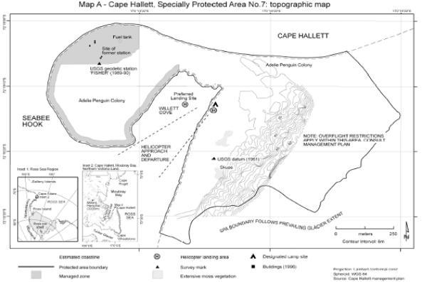
Note This map predates the current terminology — Specially Protected Area No. 7 is now ASPA No. 106.
Part 7 Antarctic specially protected area No. 107
1 Name and location
Dion Islands, Marguerite Bay, Antarctic Peninsula.
Latitude 67 53 S, longitude 68 42 W.
2 Description
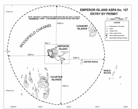
The Dion Islands (latitude 67° 53 S, longitude 68° 42 W, within a region of approximately 12 km²), situated 13.5 km south of the south‑western extremity of Adelaide Island in north‑western Marguerite Bay, is a small archipelago comprising the following islands, rocks and reefs: Envoy Rock, Regent Reef, Consort Islands (approximately 3 ha), Emperor Island (approximately 5 ha), Jester Rock, Noble Rocks, Courtier Islands (approximately 8 ha), Embassy Islands and Consul Reef.
The designated Area of just over 3 km² comprises Emperor Island and the marine environment (including sea ice when present) within 1 000 m of the coastline of Emperor Island. However, the area does not include the terrestrial areas of the Consort Islands in the north, Jester Rock in the east, or the Courtier Islands in the southwest.
3 Map
Part 8 Antarctic specially protected area No. 108
1 Name and location
Green Island, Berthelot Islands, Antarctic Peninsula.
Latitude 65 19 S, longitude 64 09 W.
2 Description
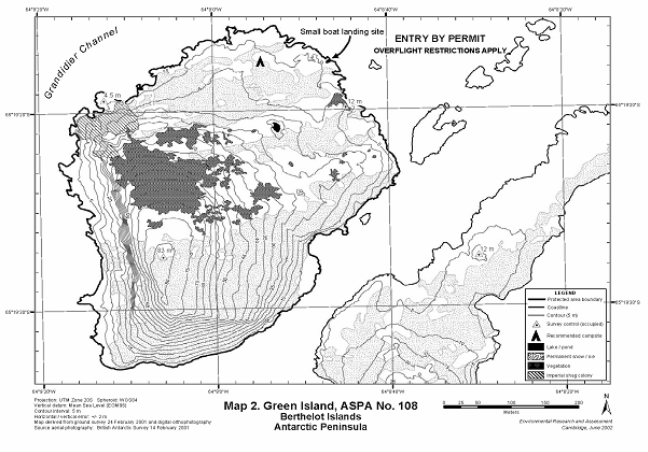
Green Island (65° 19 S, 64° 09 W, approximately 0.2 km²) is a small island situated 150 m north of the largest of the Berthelot Islands group, Grandidier Channel, approximately 3 km off the Graham Coast of the Antarctic Peninsula.
The designated area comprises the entire island, with the boundary defined as the low tide level. Offshore islets and rocks are not included within the Area. Boundary markers have not been installed. The coast itself is a clearly defined and visually obvious boundary feature.
3 Map
Part 9 Antarctic specially protected area No. 109
1 Name and location
Moe Island, South Orkney Islands.
Latitude 60 44 S, longitude 45 41 W.
2 Description
Moe Island, South Orkney Islands, is a small irregularly‑shaped island lying 300 m off the south‑western extremity of Signy Island, from which it is separated by Fyr Channel. It is about 1.3 km from the north‑east to south‑west and l km from north‑west to south‑east. Its position on Admiralty Chart No. 1775, latitude 60° 44 S, longitude 45° 45 W, does not agree closely with that in the map (latitude 60° 44 S, longitude 45° 41 W).
3 Map
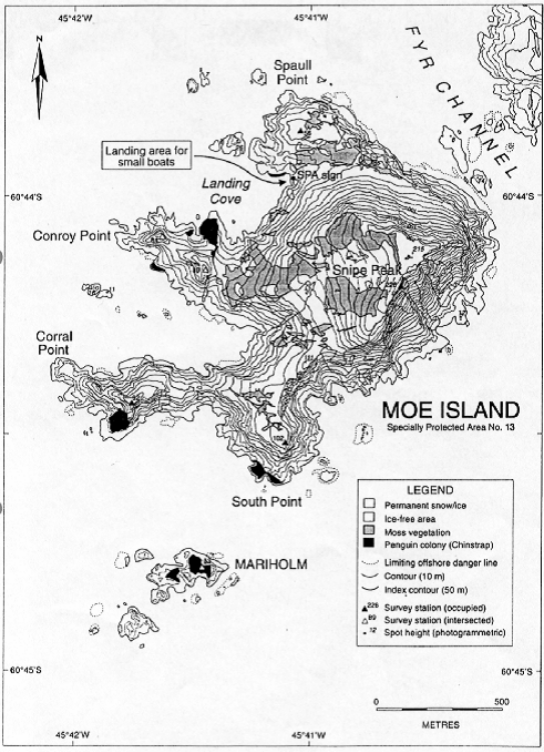
Note This map predates the current terminology — Specially Protected Area No. 13 is now ASPA No. 109.
Part 10 Antarctic specially protected area No. 110
1 Name and location
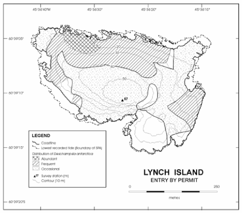
Lynch Island, South Orkney Islands.
Latitude 60 39 10 S, longitude 45 36 25 W.
2 Description
Lynch Island (latitude 60° 39 10 S, longitude 45° 36 25 W; area: 0.1 km²) is a small island situated at the eastern end of Marshall Bay in the South Orkney Islands, about 200 m south of Coronation Island and 2.4 km north of Signy Island.
The designated Area comprises the entire island above the low tide level, at which the coastline is defined as the boundary of the Area. Boundary markers have not been installed because the coast itself is a clearly defined and visually obvious boundary feature.
3 Map
Note This map predates the current terminology — SPA is now ASPA.
Part 11 Antarctic specially protected area No. 111
1 Name and location
Southern Powell Island and adjacent islands, South Orkney Islands.
Latitude 60 42 S, longitude 45 01 W.
2 Description
The Area, which is centred on latitude 60° 42 S and longitude 45° 01 W, includes all of Powell Island, South Orkney Islands, south of the latitude of the southern summit of John Peaks (375 m altitude), together with the shore of Fredriksen Island, Michelsen Island (a tidal peninsula at the southern tip of Powell Island), Christoffersen Island, Grey Island and unnamed adjacent islands.
3 Map
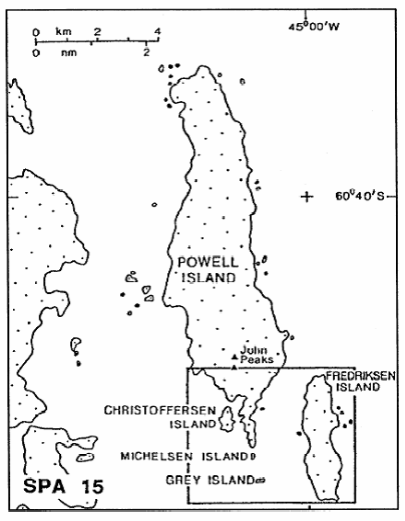
Note This map predates the current terminology — SPA 15 is now ASPA No. 111.
Part 12 Antarctic specially protected area No. 112
1 Name and location
Coppermine Peninsula, Robert Island, South Shetland Islands.
Latitude 62 23 S, longitude 59 42 W.
2 Description
Coppermine Peninsula (62° 23 S, 59° 42 W) is situated on the west side of Robert Island, which lies between Nelson Island to the east and Greenwich Island to the west, midway along the South Shetland Islands archipelago. The Area comprises all land west of a north‑south line across the isthmus between Carlota Cove and Coppermine Cove, 100 m west of a small group of Chilean refuge huts. The Peninsula is about 1.7 km from south‑east to north‑west and up to 0.6 km from north‑east to south‑west, and is largely surrounded by precipitous cliffs.
3 Map
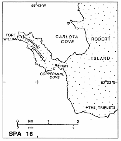
Note This map predates the current terminology — SPA No. 16 is now ASPA No. 112.
Part 13 Antarctic specially protected area No. 113
1 Name and location
Litchfield Island, Arthur Harbour, Anvers Island, Palmer Archipelago.
Latitude 64° 46′ S, longitude 64° 06′ W.
2 Description
Approximate area: 2.7 km². A small island designated on the grounds that, together with its littoral zone, it possesses an unusually rich collection of marine and terrestrial life, is unique amongst the neighbouring islands as a breeding place for six species of native birds, and provides an outstanding example of the natural ecological system of the Antarctic Peninsula area.
3 Map
Note ASPA No. 113 was formerly specially protected area No. 17 — see the Proclamation of 4 December 1980.
Part 14 Antarctic specially protected area No. 114
1 Name and location
Northern Coronation Island, South Orkney Islands.
Latitude 60 33 S, longitude 45 35 W.
2 Description
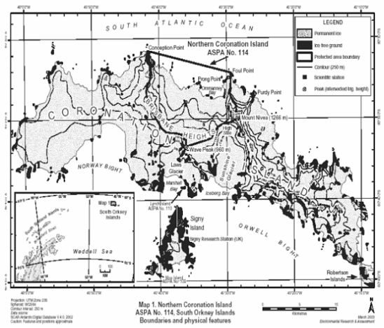
The Area includes the region of northern Coronation Island between Conception Point to the west and Foul Point to the east. The eastern boundary follows a ridge from Foul Point approximately 6 km southwards to the summit of Mount Nivea (1 266 m), thence west‑south‑westwards for a distance of 1 500 m down the ridge to the col at High Stile. From High Stile, the boundary continues west‑south‑westwards for approximately 6 km following the ridge of the broad plateau of Brisbane Heights to the summit of Wave Peak (960 m). From Wave Peak the boundary extends due north for 1 000 m, thence west and in a north‑westerly direction for about 6 km following the broad ridge of Brisbane Heights. The boundary then extends due north for approximately 6 km, following the main ridgeline to Conception Point. The glacial catchments draining to the northern coastline of Coronation Island within this boundary are within the Area. The actual summits of Mount Nivea and Wave Peak and the southern side of High Stile are outside of the Area. The northern boundary is defined as a straight line extending 11 km across the sea from Conception Point to Foul Point, including Ommanney Bay and the bay further to the west as within the Area.
3 Map
Part 15 Antarctic specially protected area No. 115
1 Name and location
Lagotellerie Island, Marguerite Bay, Antarctic Peninsula.
Latitude 67 53 20 S, longitude 67 25 30 W.
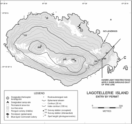
2 Description
Lagotellerie Island (latitude 67° 53 20 S, longitude 67° 25 30 W; area 1.58 km2), is situated in Marguerite Bay, Fallières Coast, Graham Land, 46 km south‑east of Rothera Point on Adelaide Island, 11 km south of Porquois Pas Island and 3.25 km west of the south end of Horseshoe Island. Lagotellerie Island is 2 km by 1.3 km, oriented generally in an east‑west direction.
The designated Area comprises the entire main island, and offshore islets within 200 m of the coast, above the low tide water level, which is defined as the boundary of the Area. Boundary markers have not been installed because the coast itself is a clearly defined and visually obvious boundary.
3 Map
Part 16 Antarctic specially protected area No. 116
1 Name and location
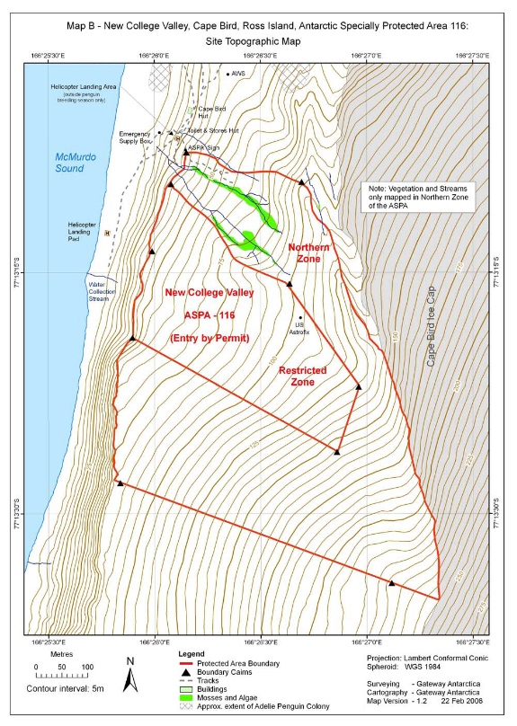
New College Valley, Caughley Beach, Cape Bird, Ross Island.
Latitude 77° 13 15.0 S, longitude 166° 26 15.0 E.
2 Description
An area of 0.33 km2 at Cape Bird was originally designated in Recommendations XIII‑8 (1985, SSSI No. 10, Caughley Beach) and XIII‑12 (1985, SPA No. 20, New College Valley) after proposals by New Zealand on the grounds that these areas contain some of the richest stands of mosses and associated microflora and fauna in the Ross Sea region of Antarctica. This is the only area on Ross Island where protection is specifically given to these ‘cold’ ground plants. SPA No. 20 was originally enclosed within SSSI No. 10 in order to provide more stringent access conditions within this part of the Area. SSSI No. 10 and SPA No. 20 have been merged in the current plan, and a Restricted Zone provides the more stringent access conditions within the former SPA. The boundaries of the Area have been revised in view of improved mapping and to follow more closely the ridges enclosing the catchment of New College Valley. Caughley Beach itself was adjacent to, but never a part of, the original Area, and for this reason the entire Area has been renamed as New College Valley, which was within both of the original sites.
Mosses (bryophytes) are the most highly evolved terrestrial plant life in this region, restricted to small, localised areas of water‑flushed ground. In addition to rich moss cushions and carpets up to 20m2, a diverse range of algal species inhabit streams in the Area, and collembolans (Gomphiocephalus hodgsoni) and mites (Nanorchestes antarcticus and Stereotydeus mollis) are plentiful on water surfaces and underneath rocks. The absence of lichens makes the species assemblage in this Area unique on Ross Island.
The proximity of the Cape Bird Hut (New Zealand) and the possibility of visits by tourists to Cape Bird mean that this vulnerable area could easily be damaged by human impact if not provided with adequate protection. Designation of this Area is designed to ensure examples of this habitat type are adequately protected from casual visitors and overuse from scientific investigations. The susceptibility of mosses to disturbance by trampling, sampling, pollution or alien introductions is such that the Area requires long‑term special protection. The ecosystem at this site is of exceptional scientific value for ecological investigations and the Restricted Zone is valuable as a reference site for future comparative studies.
3 Map
Part 17 Antarctic specially protected area No. 117
1 Name and location
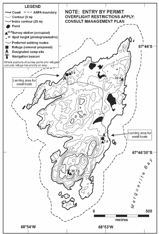
Avian Island, off Adelaide Island, Antarctic Peninsula.
Latitude 67 46 S, longitude 68 54 W.
2 Description
Avian Island (latitude 67° 46 S, longitude 68° 54 W, 0.49 km2), is situated in the north‑west of Marguerite Bay, 400 m south of the south‑western extremity of Adelaide Island. The island is 1.45 km long by 0.8 km at its widest, and is of roughly triangular shape.
The designated Area comprises the whole of Avian Island and the littoral zone, offshore islets and rocks, and a buffer zone of the surrounding marine environment (including sea ice when present) within 100 m of the shoreline of the main island. Boundary markers have not been installed because the coast forms a visually obvious reference for the marine boundary.
3 Map
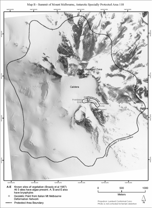
Part 18 Antarctic specially protected area No. 118
1 Name and location
Summit of Mount Melbourne, Victoria Land.
Latitude 74 21 S, longitude 164 42 E.
2 Description
Mount Melbourne (2 733 m, 74 21 S, 164 42 E) in northern Victoria Land, is situated between Wood Bay and Terra Nova Bay, on the western side of the Ross Sea, and Campbell Glacier, about 10 km to the west. The Area encompasses all terrain above the 2 200 m contour surrounding the main crater of Mount Melbourne.
3 Maps
Map A — Mount Melbourne, Antarctic specially protected area No. 118
Location, contours, ice‑free areas.
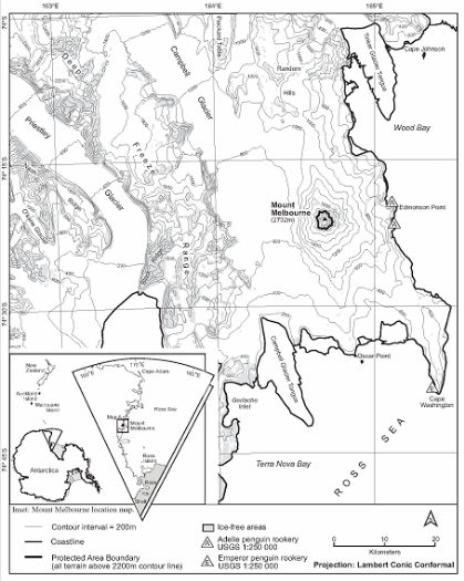
Note These maps do not appear in the management plan for APSA No. 118. They are included here for reference.
Part 19 Antarctic specially protected area No. 119
1 Name and location
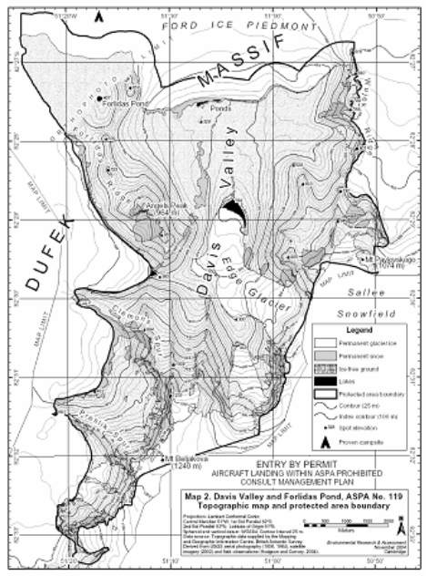
Davis Valley and Forlidas Pond, Dufek Massif.
Latitude 8227 S, longitude 5121 W.
2 Description
The Davis Valley and the adjacent ice‑free valleys is one of the most southerly ‘dry valley’ systems in Antarctica and, as of May 2005, is the most southerly protected area in Antarctica. While occupying an area of only 53 km², which is less than 1% of the area of the McMurdo Dry Valleys, the Area nevertheless contains the largest ice‑free valley system found south of 80° S in the 90º W–0º–90º E half of Antarctica. Moreover, it is the only area known in this part of Antarctica where the geomorphology preserves such a detailed record of past glacial history. Some ice‑free areas around the Weddell Sea region have scattered erratics and sometimes moraines, but the assemblage of drift limits, moraines, and abundant quartz‑bearing erratics in the Davis Valley and associated valleys is unique and rare. The location of the Dufek Massif close to the junction between the western and the eastern Antarctic ice sheets also makes this site particularly valuable for the collection of data that can be used to constrain parameters such as the past thickness and dynamics of this sector of the Antarctic ice sheet. Such data are potentially extremely valuable for understanding the response of the Antarctic ice sheet to climate change. The Area therefore has exceptional and unique scientific value for the interpretation of past glacial events and climate in this part of Antarctica and it is important that this value is maintained.
The terrestrial ecology of the Area is impoverished but is also highly unusual, with lake and meltwater stream environments and their associated biota being rare this far south in Antarctica. As such, they provide unique opportunities for the scientific study of biological communities near the extreme limit of the occurrence of these environments. Vegetation appears to be limited to cyanobacterial mats and a very sparse occurrence of small crustose lichens. The cyanobacterial mat growth in the terrestrial locations is surprisingly extensive, and represents the best examples of this community type known this far south. The cyanobacterial community appears to survive in at least three distinct environments:
in the permanent water bodies; and
in exposed terrestrial locations, particularly at the boundaries of sorted polygons; and
in a series of former or seasonally dry pond beds on ice‑free ground in the Davis Valley.
No arthropods or nematodes have thus far been detected in samples taken from within the Area, and the invertebrate fauna in the Area is unusually sparse. This characteristic distinguishes the Area from more northerly ice‑free valley systems such as those at the Ablation Valley — Ganymede Heights (ASPA No. 147), Alexander Island, or at the McMurdo Dry Valleys (ASMA No. 2), where such communities are present. Rotifers and tardigrades have been extracted from samples taken within the Area, with the greatest numbers occurring within the former pond beds in the Davis Valley, although their diversity and abundance is also extremely limited compared with more northerly Antarctic sites (Hodgson and Convey, 2004). Further analyses of the samples obtained and identification of all taxa present are in progress, and are expected to make an important contribution to the understanding of biogeographical relationships between the different regions of Antarctica.
The Area is extremely isolated and difficult to access, and as a result has been visited by only a small number of people. Reports indicate that small field parties visited the Area in December 1957, in the 1965–66 and 1973–74 austral summer seasons, in December 1978 and in December 2003. The total number of people having visited probably numbers less than 50, with visits generally limited to a period of a few weeks or days. No structures or installations have been built within the Area, and as far as is known all equipment brought into the Area has subsequently been removed. While Hodgson and Convey (2004) reported evidence of a very limited number of human footprints and several old soil pit excavations, the Area has been exposed to few opportunities for direct human impact. The Area is believed to be one of the most pristine ice‑free valley systems in Antarctica, and is therefore considered to possess outstanding potential as a reference area for microbiological studies, and it is important that these values receive long‑term protection.
The site possesses outstanding wilderness and aesthetic values. The dry and weathered brown valleys of the Area are surrounded by extensive ice‑fields, the margins of which fringe the valleys with dry based glacial ice of a deep blue hue. This abrupt and dramatic blue‑ice margin stands in stark contrast to the stony and barren ice‑free landscape of the valleys, and aesthetically is extremely striking in appearance. One of the original explorers of this area in 1957 recalled “the excitement we felt at being the first people to view and enter this magnificently scenic, pristine area.” (Behrendt, 1998: 354). Further examples of descriptions of the Area by visitors are: “[the blue ice] was towering over us — 150 feet — a large wave of blue. It was like being in a tidal wave that was held in suspension as we walked under it…”(Reynolds, field notes, 1978), and “I still cannot find adequate superlatives to describe the features, whether large or small, biologic or physical… [Of the] many settings that stretch the imagination…in my experience none match the northern side of the Dufek Massif, with Davis Valley as its crown jewel.” (Reynolds, pers. comm., 2000); “the most unusual [landscape] I have ever seen on any of the seven continents” (Boyer, pers. comm., 2000); “Probably the single most remarkable environment I’ve been, either in Antarctica or elsewhere” (Convey, pers. comm., 2004). Burt (2004) described the region simply as “inspiringly awesome”.
The boundaries of the Area have been revised to include the entire ice‑free region centered on the Davis Valley, including the adjacent valleys and Forlidas Pond. In general, the margins of the surrounding ice sheets form the new boundary of the Area, resulting in special protection of the region as an integrated ice‑free unit that more closely approximates the valley catchments. The full catchments of the surrounding glaciers that flow into these valleys extend considerable distances from the ice‑free area and do not possess many of the values related to the purpose of special protection, and are therefore excluded from the Area.
3 Map
Part 20 Antarctic specially protected area No. 120
1 Name and location
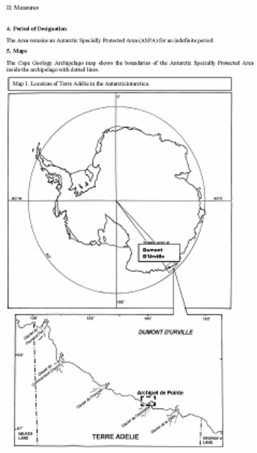
Pointe‑Geologie, Terre Adélie.
Latitude 66 40 S, longitude 140 02 E.
2 Description
In 1995, four islands, a nunatak and a breeding ground for Emperor penguins were classified as an Antarctic Specially Protected Area (Measure 3 (1995), XIX ATCM, Seoul) because they were a representative example of terrestrial Antarctic ecosystems from a biological, geological and aesthetics perspective. A species of marine mammal, the Weddell seal (Leptonychotes weddelli), and various species of birds breed in the area: Emperor penguin (Aptenodytes forsteri); Antarctic skua (Catharacta maccormicki); Adélie penguins (Pygoscelis adeliae); Wilson’s petrel (Oceanites oceanicus); southern giant petrel (Macronectes giganteus); Snow petrel (Pagodrama nivea); Cape petrel (Daption capense).
Well‑marked hills display asymmetrical transverse profiles with gently dipping northern slopes compared to the steeper southern ones. The terrain is affected by numerous cracks and fractures leading to very rough surfaces. The basement rocks consist mainly of sillimanite, cordierite and garnet‑rich gneisses which are intruded by abundant dikes of pink anatexites. The lowest parts of the islands are covered by morainic boulders with a heterogenous granulometry (from a few centimetres to more than a metre across).
Long‑term research and monitoring programs of birds and marine mammals have been going on for a long time already (since 1952 or 1964 according to the species). A database implemented in 1981 is directed by the Centre d’Etudes Biologiques de Chize (CEBC‑CNRS). Human scientific presence may be estimated at around four people for a few hours, twice a month in the protected area.
Among the approximately 30 Emperor penguin breeding sites on record, this is the only one located adjacent to a permanent station. It is therefore a providential spot to study this species and its environment.
3 Map
The Cape Geology Archipelago map shows the boundaries of the Antarctic Specially Protected Area inside the archipelago with dotted lines.
Part 21 Antarctic specially protected area No. 121
1 Name and location
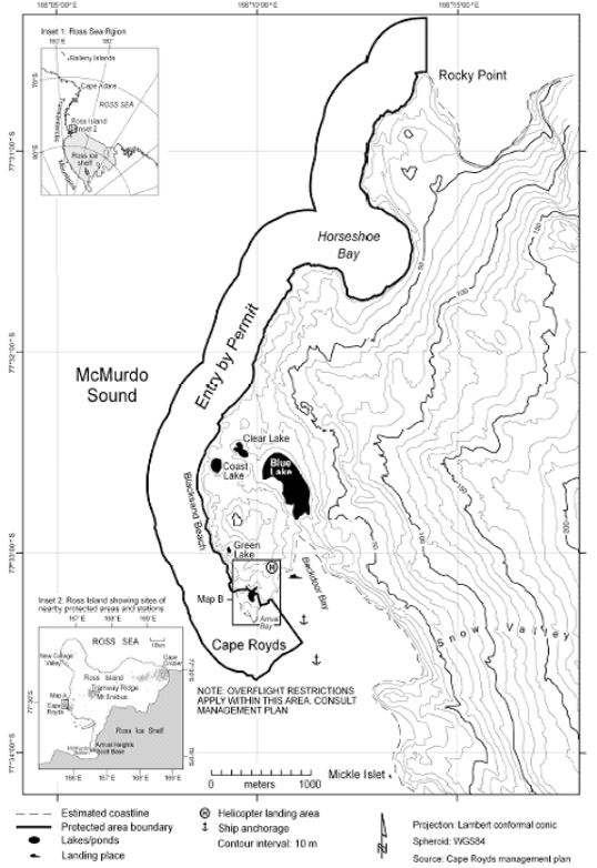
Cape Royds, Ross Island.
Latitude 77 33 20 S, longitude 166 09 56 E.
2 Description
Cape Royds (77° 33 20 S, 166° 09 56 E) is situated on the west side of Ross Island, McMurdo Sound, at the western extremity of a coastal strip of ice‑free land approximately 8 km wide, on the west slope of Mount Erebus. The Area comprises both a terrestrial and marine component.
The marine component of the Area extends for approximately 5 km from Derrick Point in the south to Rocky Point in the north, including Horseshoe Bay. The marine boundary is defined as extending north‑east along the Arrival Bay coastline from the most easterly corner of the terrestrial boundary at Arrival Bay (77° 33 15.9 S, 166° 10 06 E) to Derrick Point (77° 33 14.1 S, 166° 10 22 E). From Derrick Point the marine boundary extends offshore 500 m in a south‑east direction and thence extends parallel to the coast 500 m offshore from the mean high water mark, around Cape Royds and north for 5.3 km to a point 500 m due north of Rocky Point then due south to Rocky Point.
The terrestrial component of the Area consists of ice‑free land within approximately 350 m of Cape Royds itself (77° 33 20 S, 166° 09 56 E). Much of this land is seasonally occupied by a breeding Adélie penguin colony. The boundary of this part of the Area has been revised from the original description so as to include all of the area occupied by breeding penguins in 1995/96 and the main southern access route of the penguins to the sea. The north boundary of the territorial component of the Area extends 45 m from a small embayment, on the west side and 350 m north of Cape Royds, in a straight line north‑east to a survey mark identified on earlier New Zealand maps as IT2 (77° 33 11.1 S, 166° 09 33.3 E), which is an iron tube embedded in the ground. This line extends 10 m east from IT2 to a signpost (77° 33 11.1 S, 166° 09 34.8 E), then a further 80 m east to a signpost (77° 33 11.0 S, 166° 09 46.1 E) at the south end of a small pond at the north end of Pony Lake. From this signpost the boundary extends in a south‑east direction for 114 m just north of the lake to the eastern edge of the lake (77° 33 12.6 S, 166° 10 01.3 E). The east boundary then extends 86 m in a south‑south‑east direction to a third signpost (77° 33 15.2 S, 166° 10 05 E), thence to the coast on the east side of Arrival Bay (77° 33 15.9 S, 166° 10 06.0 E). All of the ice‑free ground, snow‑patches and freshwater bodies contained west and south of the line defined above to the coast extending around Cape Royds is included within the Area.
3 Map
Part 22 Antarctic specially protected area No. 122
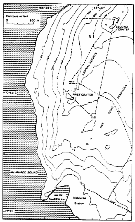
1 Name
Arrival Heights, Hut Point Peninsula, Ross Island.
2 Description
All that area of Arrival Heights enclosed with a line drawn from Trig T510 north‑west over First crater to the 500‑foot contour, then north along this contour to a point immediately west of Second Crater, then around the lip of this crater and south to Trig T510. The boundary, which is demarcated, is shown on the maps.
3 Maps
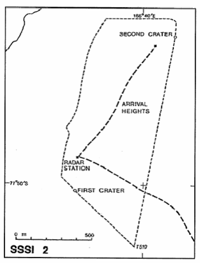
Note This map predates the current terminology — SSSI 2 is now ASPA No. 122.
Part 23 Antarctic specially protected area No. 123
1 Name
Barwick Valley, Victoria Land.
2 Description
Barwick Valley is situated about 65 km inland from the Ross Sea coast of South Victoria Land. The Area includes Barwick and Balham Valleys and their respective catchments and is bordered on the south, west and north by the McKelvey Valley, the Willet Range and the divide between the Victoria and Barwick Valleys, respectively.
The boundary of the Area extends from its eastern extremity in the lower Barwick Valley (around the confluence of the Barwick, Victoria and McKelvey Valleys) several kilometres south towards the ridge leading south‑west to the summit of Mount Insel (1 345 m), from where the boundary follows the high points of the ridge of the Insel Range for 5 km before descending to a low pass between the McKelvey and Balham Valleys at the location of Bullseye Lake. The boundary crosses the lake before ascending the ridge to a further high point on the Insel Range (approximately 1 250 m), and continues towards the upper reaches of the Balham Valley. As the terrain becomes gentler in the upper Balham, the boundary sweeps north approximately above the 1 800 m contour line. The boundary skirts around the summit of Shapeless Mountain until it cuts north‑west at a point west of the Apocalypse Peaks. The boundary joins and follows a prominent ridge to the summit of Mount Bastion (2 477 m, 160° 34 E, 77° 19 S). This ridge is followed in a northerly direction to Skew Peak (2 535 m, 160° 26 E, 77° 13 S), located at the head of the Barwick Valley. The boundary then descends along the East Ridge of Skew Peak above Webb Glacier, before following the catchment boundary in a more southerly direction toward Parker Mesa. From Parker Mesa the boundary descends further to follow the dividing ridge between the catchments of the Victoria Upper Glacier and the Barwick Valley. The boundary extends east along this ridge for 13 km to Sponsors Peak (1 454 m, 161° 24 E, 77° 18 S). The boundary descends the south‑west Ridge of Sponsors Peak and Nickell Peak (approximately 1 400 m) to the lower Barwick to the eastern extremity of the Area, which is about 3 km north‑east of Lake Vida, Victoria Valley.
3 Map
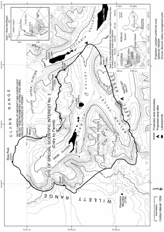
Note This map predates the current terminology — Site of Special Scientific Interest No. 3 is now ASPA No. 123.
Part 24 Antarctic specially protected area No. 124
1 Name
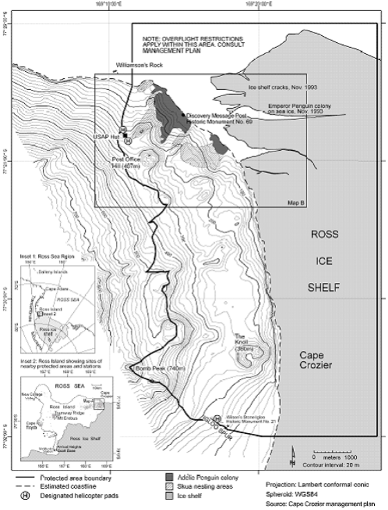
Cape Crozier, Ross Island.
2 Description
Cape Crozier is at the eastern extremity of Ross Island, where an ice‑free area comprises the lower eastern slopes of Mount Terror. The designated area is situated in the vicinity of Post Office Hill (407 m), extending to encompass the adjacent Ross Ice Shelf where large cracks in the shelf are covered by fast ice which is occupied annually by breeding Emperor penguins.
The Area includes a terrestrial region and ice shelf above the mean high water mark as well as the adjacent fast ice within the boundaries occupied by breeding Emperor penguins. The north boundary of the Area extends 6.5 km along the 77° 26 03 S line of latitude from 169° 11 43 E to 169° 28 00 E. The west boundary extends 1.5 km south from the northern boundary to the coast, thence in a north‑east direction following a low ice‑free ridge that passes 30 m west of the hut and helicopter pad. The boundary then follows this ridge in a southerly direction to be south‑west of the summit of Post Office Hill before following another ridge in a south‑east direction to the summit of a small unnamed peak (335 m) 1.2 km south‑south‑east of Post Office Hill. The boundary descends down a south‑west ridgeline, before following this ridge to ascend to the summit of a large unnamed volcanic cone (520 m) 3.6 km south of Post Office Hill. The boundary follows around the eastern side of this cone before descending south through a valley to another unnamed conic peak (580 m) 1.5 km north‑north‑east of Bomb Peak. The boundary follows a ridge through the middle of the cone before descending down a ridge on the southern side of the peak into a valley at the base of Bomb Peak. The boundary ascends the northern side of Bomb Peak to the summit (>610 m) before extending down a ridge line on the south‑east side of Bomb Peak to Igloo Spur and thence due east along latitude 77° 32 00 S to the east boundary at 169° 28 00 E.
3 Map
Part 25 Antarctic specially protected area No. 125
Note The declaration of this area as an Antarctic specially protected area ceases to have effect at the end of 31 December 2010 — see section 6.
1 Name
Fildes Peninsula, King George Island, South Shetland Islands.
2 Description
The two areas on Fildes Peninsula shown on the map will be demarcated.
3 Map
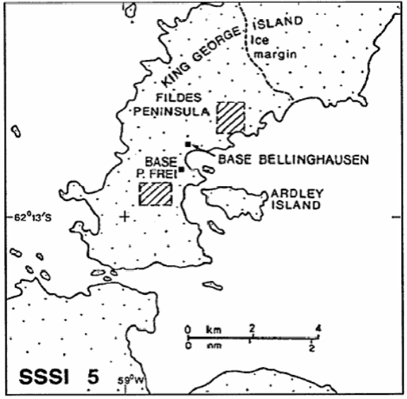
Note This map predates the current terminology — SSSI 5 is now ASPA No. 125.
Part 26 Antarctic specially protected area No. 126
1 Name and location
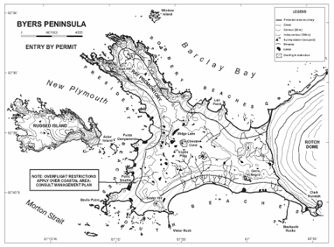
Byers Peninsula, Livingston Island, South Shetland Islands.
Latitude 62 34 35 S to 62 40 35 S, longitude 60 54 14 W to 61 13 07 W.
2 Description
Byers Peninsula (between latitudes 62° 34 35 and 62° 40 35 S and longitudes 60° 54 14 and 61° 13 07 W, 60.6 km2) is situated at the west end of Livingston Island, the second largest of the South Shetland Islands. The peninsula has a central west‑east extent of about 9 km and a north‑west south‑east extent of 18.2 km, and is the largest ice‑free area in the South Shetland Islands.
The boundaries of the Area designated under Recommendation XVI‑5 have been changed. The Area now includes two islets several hundred metres south‑west of Devils Point and a small area of ice‑free ground at Clark Nunatak in the south‑east corner as these sites also support values consistent with the remainder of the Peninsula. The Area is now defined to include the whole of Byers Peninsula west of the permanent ice sheet of Rotch Dome, Livingston Island, above the low tide water level, including the two islets adjacent to Devils Point noted above, but excluding all other offshore islets and rocks.
3 Map
Part 27 Antarctic specially protected area No. 127
1 Name and location
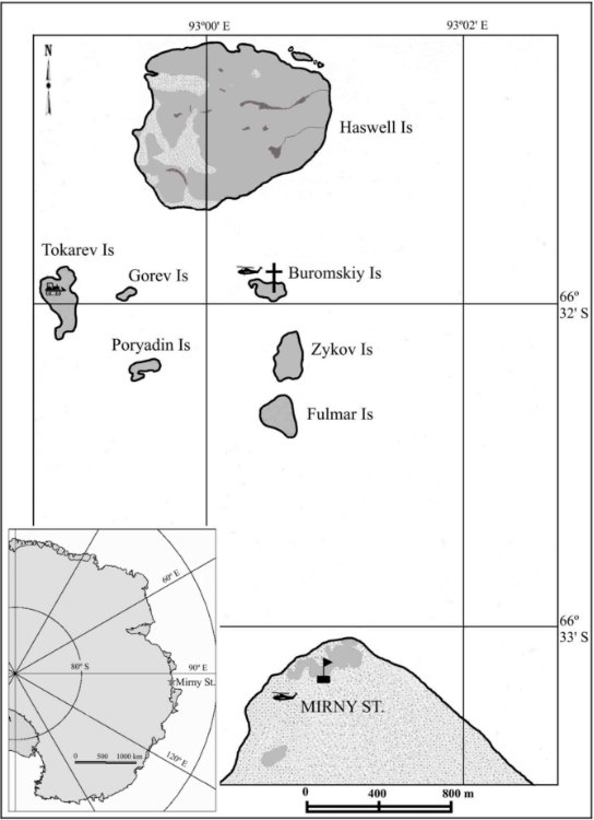
Haswell Island (Haswell Island and adjacent Emperor penguin rookery on Fast Ice), Davis Sea, East Antarctica.
Latitude 66º 31 S, longitude 93º 00 E.
2 Description
Haswell Island is a unique breeding site for almost all breeding bird species in East Antarctica including the Antarctic petrel (Talassoica antarctica), Antarctic fulmar (Fulmarus glacioloides), Cape petrel (Daption capense), Snow petrel (Pagodroma nivea), Wilson’s storm petrel (Oceanites oceanicus), South Polar skua (Catharacta maccormicki), and Adélie penguin (Pygoscelis adeliae). The Area supports five species of pinnipeds, including the Ross seal (Ommatophoca rossii), which is a specially protected species.
South‑east of the island, there is a large colony of Emperor penguins (Aptenodytes forsteri) on fast ice.
The Area consists of Haswell Island (66º 31S, 93º 00E), about 1 km2 in area, the largest of a group of islands lying close to Mirny station, together with its littoral zone and the area of fast ice, when present. ATCM VIII (Oslo, 1975) approved its designation as SSSI 7 on the aforementioned grounds after a proposal by the USSR. Map 1 shows the location of the Haswell Islands (except Vkhodnoy Island), Mirny Station, and logistic activity sites. It was renamed and renumbered as ASPA No. 127 by Measure 1 (2002).
The boundaries of the Antarctic specially protected area, Haswell Island (66º 31 S, 93º 00 E, about 1 km2 in area) and the adjacent section of Davis Sea fast ice of approximately 5 km2 (when present), which supports a colony of Emperor penguins, are detailed in Map 2. It is one of a few Emperor penguin colonies in the vicinity of a permanent Antarctic station, and therefore it has advantages for the study of the species and its habitat.
Described by biologists during the first Soviet expeditions, the Area was studied in the 1970s and recent years, providing valuable materials for comparative analyses and monitoring of the long‑term environmental impact of a large Antarctic station.
3 Maps
Map 1
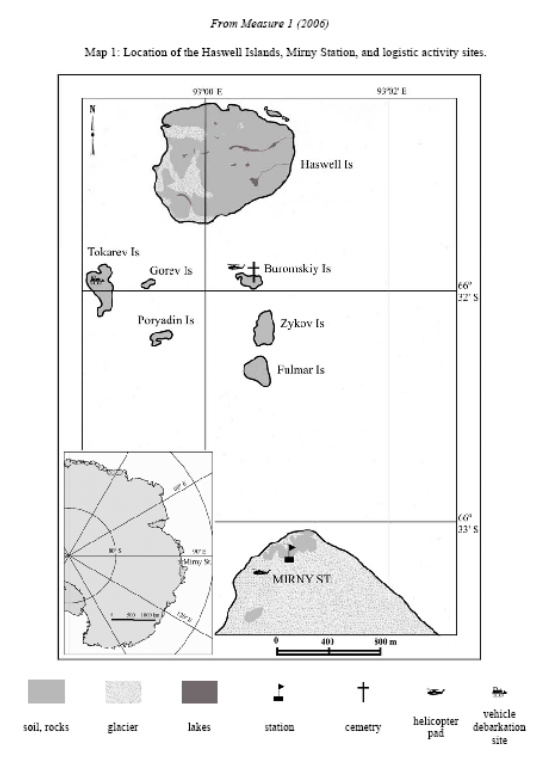
Map 2
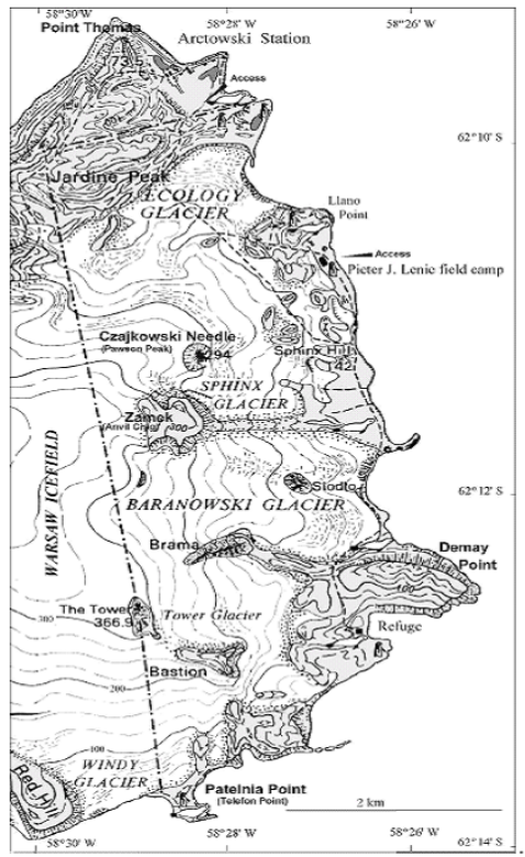
Part 28 Antarctic specially protected area No. 128
1 Name
Western shore of Admiralty Bay, King George Island.
2 Description
The area consists of land on the western shore of Admiralty Bay. The westerly boundary extends from Patelnia (Telefon) Point (62° 13 55 S, 58° 28 45 W), north‑north‑west to The Tower (a distinctive peak above Tower Glacier, 366.9 m at 62° 12 50 S, 58° 29 00 W), then continuing in a straight line to encompass the base of Jardine Peak (62° 10 05 S, 58° 29 45 W). This line then runs north‑east to the sea (Admiralty Bay) where it bisects the coast immediately north of Rakusa Point (62° 09 45 S, 58° 27 25 W). Thereafter the Area is all the land which is bounded by the coastline south towards Demay Point (62° 12 50 S, 58° 25 15 W), then south‑west along the coast to Patelnia (Telefon) Point. The western edge of the Area is adjacent to the Warsaw Icefield, with the north‑western corner being ice‑free in the vicinity of Jardine Peak. Outside of the northern boundary is a small area of ice‑free land. Steep cliffs overlook a narrow beach and the waters of Ezcurra Inlet in the north‑western section of the ice‑free area; and in the north‑eastern section there are occasional shallow beaches which extend to the sea, where H. Arctowski station is located, 400 m outside of the Area. Three small glaciers, Ecology, Baranowski, and Tower, descend from the Warsaw Icefield onto these shores. There are markers on the northern edge of the Area where the site has a boundary on land, immediately south of H. Arctowski station. The western boundary is not delineated by virtue of fact that it traverses a high (ca. 350 m) mobile icefield. The coastline defines the Area’s eastern and southern stretches.
3 Map
Part 29 Antarctic specially protected area No. 129
1 Name and location
Rothera Point, Adelaide Island.
Latitude 67 34 S, longitude 68 08 W.
2 Description
Rothera Point (latitude 67° 34 S, longitude 68° 08 W) is situated in Ryder Bay, at the south‑east corner of Wright Peninsula on the east side of Adelaide Island, south‑west Antarctic Peninsula. The site is the north‑eastern one‑third of Rothera Point, and is representative of the area as a whole. It is about 30 m from west to east and 250 m from north to south, and rises to a maximum height of 36 m. At the coast, the site boundary is the 2.5 m contour. No upper shore, littoral or sublittoral areas of Rothera Point are therefore included. The southern boundary of the site, running across Rothera Point, is marked by a line of pink fuel drums filled with concrete. The remaining boundary is unmarked.
3 Map
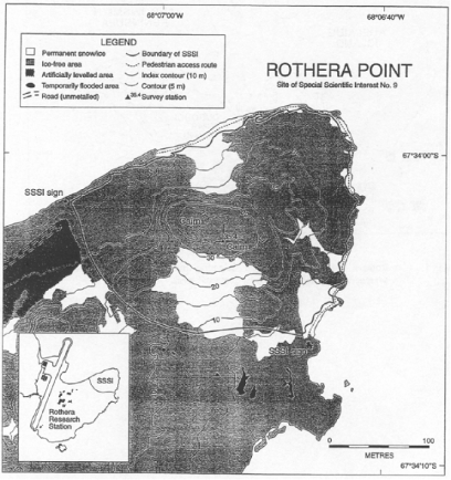
Note This map predates the current terminology — Site of Special Scientific Interest No. 9 is now ASPA No. 129 and SSSI is now ASPA.
Part 30 Antarctic specially protected area No. 130
1 Name and location
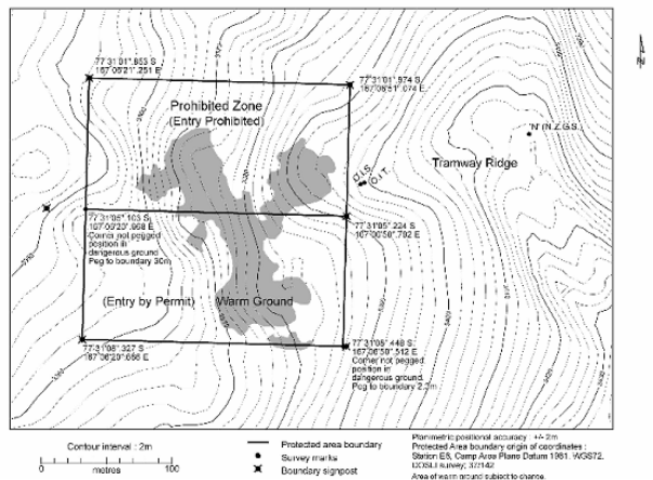
Tramway Ridge, Mount Erebus, Ross Island.
Latitude 77 31 05 S, longitude 167 06 35 E.
2 Description
The boundary of the designated Area is defined as a square of 200 m by 200.8 m which encompasses most of the warm ground area of lower Tramway Ridge (77° 31 05 S, 167° 06 35 E). The Area is divided into two parts of almost equal size, the northern half being a Prohibited Zone. The boundaries of the Area and the Prohibited Zone (marked by signposts at each corner) and prominent features are shown on the map. Several boundary signposts have been offset owing to dangerous ground at the actual corner point.
3 Map
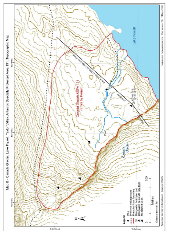
Part 31 Antarctic specially protected area No. 131
1 Name and location
Canada Glacier, Lake Fryxell, Taylor Valley, Victoria Land.
Latitude 77° 37 00.0 S, longitude 162° 59 00.0 E.
2 Description
An area of 1 km2 to the east side of Canada Glacier was originally designated in Recommendation XIII‑8 (1985) as SSSI No. 12 after a proposal by New Zealand on the grounds that it contains some of the richest plant growth (bryophytes and algae) in the southern Victoria Land Dry Valleys. As such, the Area is of exceptional intrinsic ecological value and is also of scientific value to botanists, zoologists and microbiologists. The Area is designated primarily to protect the site’s ecological values. It is also valuable as a reference site for other dry valley ecosystems.
The boundaries of this site have been changed such that the Area now includes biologically rich communities that were previously excluded. The Area comprises sloping ice‑free ground with summer ponds and small meltwater streams draining from the Canada Glacier to Lake Fryxell. Most of the plant growth occurs in a flush area close to the glacier in the central part of the Area. The composition and distribution of the plant communities in the Area are correlated closely with the water regime. Thus, water courses and water quality are important to the values of the site. The Area is unusual in that it receives more consistent water flows compared with many other parts of the south Victoria Land Dry Valleys, and is sheltered from strong winds by the nearby 20 m glacier face.
The Area has been well‑studied and documented, which adds to its scientific value. However, the plant communities are fragile and vulnerable to disturbance and destruction by trampling and sampling. Damaged areas will be slow to recolonise. Sites damaged at known times in the past have been identified, which are valuable in that they provide one of the few areas in the Dry Valleys where the long‑term effects of disturbance, and recovery rates, can be measured.
The Area requires long‑term special protection because of its exceptional moss communities for the south Victoria Land Dry Valleys and thus ecological importance; its scientific values; the limited geographical extent of the ecosystem; the vulnerability of the Area to disturbance through trampling, sampling, pollution or alien introductions; and in view of the existing and increasing pressure from scientific, logistic and tourist activities in the region.
3 Map
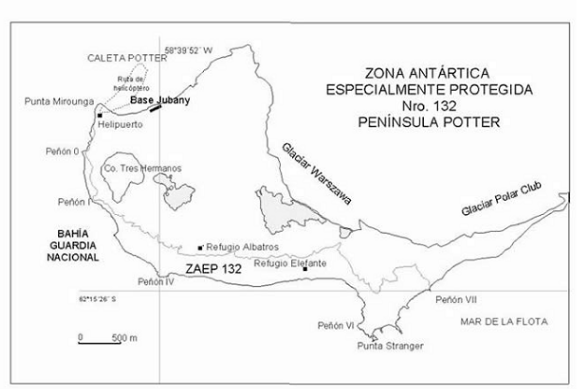
Part 32 Antarctic specially protected area No. 132
1 Name and location
Potter Peninsula, King George Island, South Shetland Islands.
Latitude 62 15 S, longitude 59 39 W.
2 Description
The area encompasses important scientific values due to the presence of groups of breeding elephant seals (Mirounga leonina), and non‑breeding groups of Antarctic fur seals (Arctocephalus gazella) and occasionally of Weddell seals (Leptonychotes weddelli), crabeater seals (Lobodon carcinophagus) and leopard seals (Hydrurga leptonyx). During the breeding season there are around 500 elephant seals around, and during the fledging season, between 200 and 600. The non‑breeding groups of Antarctic fur seals can add up to 300 individuals, although that figure may vary considerably from one year to the next.
Also present are significant colonies of gentoo penguins (Pygoscelis papua) and Adélie penguins (Pygoscelis adeliae), each of them with an approximate population of 4 000 pairs. Penguin colonies are mainly distributed around Stranger Point, from the vicinity of Elefante refuge to Spur 7. Within the ASPA, the population of storm petrels (by large the Oceanites oceanicus and, to a much lesser extent, the Fregetta tropica) reaches some 200 pairs. Antarctic terns (Sterna vittata), southern giant petrels (Macronectes giganteus) and skuas (Catharacta sp.) also breed in the area, although their populations are, in all cases, less than 100 pairs each. Southern giant petrel nesting sites concentrate on the western side of the ASPA. As some of the nesting sites around Potter Peninsula change their position over time, population figures are estimations and may introduce some degree of inaccuracy, depending on the year considered.
3 Map
General location of Antarctic Specially Protected Area No. 132, Potter Peninsula (King George Island), in relation to the Antarctic Peninsula.
Part 33 Antarctic specially protected area No. 133
1 Name and location
Harmony Point, Nelson Island, South Shetland Islands.
Latitude 6218 S, longitude 5911 W.
2 Description
Geomorphologically, Harmony Point presents three well defined units: an andesitic plateau, coastal and shelf outcrops and ancient sea levels. The plateau reaches 40 m above sea level and its area is covered by detritus resulting from the action of erosion agents on andesitic rocks, with a well‑developed vegetation of mosses and lichens.
There are three successive raised paleobeaches, between the coast and the glacier. The paleobeaches are defined by pebble accumulations of variable height in some instances and the development of soil in others.
Lakes and streams with a limited flow appear on the undulations. Some isolated andesitic rocks and ancient nunataks can be seen outside the limits of the glacier, evidencing that the past extension of the glacier covered Harmony Point.
The Area holds breeding colonies of 12 species: 3347 pairs of gentoo penguins (Pygoscelis papua), 89 685 pairs of chinstrap penguins (Pygoscelis antarctica), 746 pairs of southern giant petrels (Macronectes giganteus), 479 pairs of Cape petrel (Daption capense), 45 pairs of blue eyed shag (Phalacrocorax atriceps), 144 pairs of snowy sheathbill (Chionis alba), 71 pairs of skuas (61 pairs of Antarctic skuas (Catharacta antarctica) and 11 pairs of South Polar skuas (Catharacta maccormicki)), 128 pairs of Dominican gull (Larus dominicanus) and between 100 and 150 individuals of Antarctic terns (Sterna vittata).
Other seabirds nesting in the Area are the Wilson’s storm petrel (Oceanites oceanicus) and the black‑bellied storm petrel (Fregetta tropica). Together they represent around 1 000 pairs. Map 4 shows the distribution of bird concentrations at Harmony Point.
There are usually three species of mammals in the Area: the Weddell seal (Leptonychotes weddelli), the elephant seal (Mirounga leonina) and the Antarctic fur seal (Arctocephalus gazella). Occasionally some individual crabeater seals (Lobodon carcinophagus) have also been seen. The number of mammals in the area varies. The maximum numbers of Antarctic fur seals, Weddell seals and elephant seals are 320, 550 and 100 respectively. The Weddell seals usually breed in the Area in high figures, reaching up to 60 females with their pups in a single season. Births of fur and elephant seals have also been recorded, although the numbers there are much lower.
There are some extensive areas covered by a very rich and diverse development of bryophytes and lichen‑dominated plant communities (presently being classified), including, although to a lesser degree, two vascular plant species (Deschampsia antarctica and Colobanthus quitensis), especially in the areas less affected by recent anthropic perturbation or breeding activities. Moss turf subformations are located in wind protected and moist places, whilst lichen‑dominated subformations occur in places with a high wind exposure. Five soil orders have been identified so far in the Area, according to the taxonomic system: Soil Taxonomy (1999): histosols (hydric cryfibrists), entisols (lithic criorthents), spodosols (oxiaquic humicryods), mollisols (lithic haplocryolls) and inceptisols (lithic eutrocryepts e histic cryaquepts).
3 Map

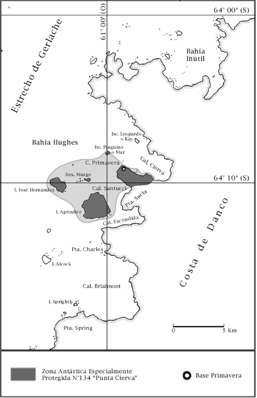
Part 34 Antarctic specially protected area No. 134
1 Name and location
Cierva Point and Offshore Islands, Danco Coast, Antarctic Peninsula.
Latitude 64° 0923 S, longitude 60° 5717 W.
2 Description
This area was originally designated as Site of Special Scientific Interest No. 15 in ATCM Recommendation XIII‑8, after a proposal by Argentina, as an important example of well developed maritime vegetation having breeding colonies of at least five bird species.
During the XXI Antarctic Treaty Consultative Meeting (Christchurch, 1997), the revised management plan for the Area was adopted in accordance with the format established by Annex V and Measure 3 (1997). During the XXV Antarctic Treaty Consultative Meeting (Warsaw, 2002), Annex V having entered into force, the SSSI No. 15 became, by Decision 1 (2002), Antarctic specially protected area No. 134.
The original reasons for the designation of the Area are still relevant. This Area has great scientific value due to its unusual biodiversity, which includes numerous species of birds, flora, and invertebrates. The unique topography of the Area together with the abundance and diversity of the vegetation create highly favourable conditions for the formation of numerous microhabitats which, in turn, support the development of biodiversity and give the Area exceptional aesthetic value.
Long‑term research programs could be endangered by accidental human interference, destruction of vegetation and soil, pollution of water bodies, and perturbation of birds, especially during reproductive periods.
3 Map
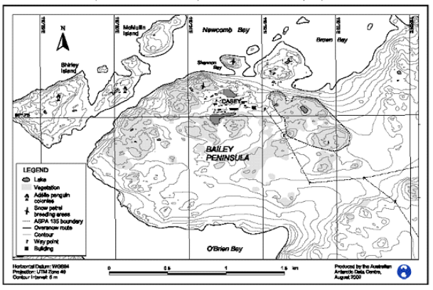
Part 35 Antarctic specially protected area No. 135
1 Name and location
North‑east Bailey Peninsula, Budd Coast, Wilkes Land.
Latitude 66 17 S, longitude 110 32 E.
2 Description
The Area consists of an irregular area of exposed rock during summer on the north‑east of Bailey Peninsula, with the north‑western portion of the Area approximately 70 m south of Brown Bay with Casey Station (66 16 59.9 S, 110 31 59.9 E) approximately 200 m to the west. Boundary coordinates for the Area are shown in the following table.
Boundary point | Longitude | Latitude |
1 | 110 32 42 E | 66° 17 03 S |
2 | 110 32 56 E | 66° 17 11 S |
3 | 110 32 50 E | 66° 17 11 S |
4 | 110 32 41 E | 66 17 10 S |
5 | 110 32 22 E | 66 17 07 S |
6 | 110 32 20 E | 66 17 06 S |
7 | 110 32 18 E | 66 17 02 S |
8 | 110 32 18 E | 66 17 00 S |
9 | 110 32 14 E | 66 16 60 S |
10 | 110 32 09 E | 66 16 56 S |
11 | 110 32 08 E | 66 16 54 S |
12 | 110 32 05 E | 66 16 54 S |
13 | 110 32 07 E | 66 16 52 S |
14 | 110 32 07 E | 66 16 52 S |
15 | 110 32 12 E | 66 16 51 S |
16 | 110 32 16 E | 66 16 52 S |
17 | 110 32 19 E | 66 16 53 S |
18 | 110 32 19 E | 66 16 55 S |
19 | 110 32 24 E | 66 16 55 S |
20 | 110 32 25 E | 66 16 53 S |
21 | 110 32 29 E | 66 16 53 S |
22 | 110 32 44 E | 66 16 54 S |
23 | 110 33 09 E | 66 17 05 S |
24 | 110 33 11 E | 66 17 06 S |
25 | 110 33 10 E | 66 17 09 S |
26 | 110 33 02 E | 66 17 11 S |
27 | 110 32 56 E | 66 17 11 S |
3 Map
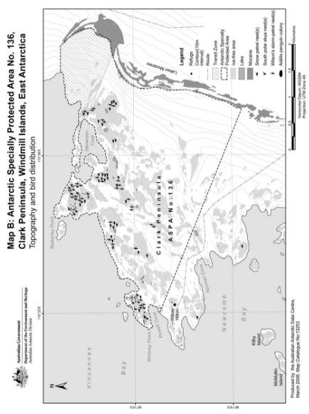
Part 36 Antarctic specially protected area No. 136
1 Name and location
Clark Peninsula, Budd Coast, Wilkes Land.
Latitude 66 15 S, longitude 110 36 E.
2 Description
With the exception of the Antarctic Peninsula, the largely undisturbed terrestrial ecosystem of Clark Peninsula supports one of the most extensive and best developed plant communities on continental Antarctica. The Area has rich associations of macrolichens and bryophytes that occupy very specific ecological niches. Within the relatively complex plant communities, 33 species of bryophytes and macrolichens have been found with 11 cryptogamic associations being identified. This vegetation forms a continuum of ecological variation along environmental gradients of soil moisture, soil chemistry and microclimate. As such, the Area has intrinsic ecological value and scientific importance, particularly in the fields of botany, microbiology, soil science and glacial geomorphology.
Moss and lichen communities in the Area are used as control plots to monitor the environmental impacts of Casey Station. The Area provides baseline and comparative data with which to compare changes in similar plant communities in the immediate surroundings of Casey Station. The cryptogamic plant communities are also being monitored in relation to short‑term microclimate fluctuation and long‑term climate change in the region since deglaciation 8000–5000 years before present (BP).
Significant and relatively undisturbed breeding populations of Adélie penguin (Pygoscelis adeliae) and South Polar skuas (Catharacta maccormicki) are present within the Area at Whitney and Blakeney Points. In addition, breeding Wilson's storm petrels (Oceanites oceanicus) and Snow petrels (Pagodroma nivea) are present in most ice‑free areas. The monitoring of the breeding populations of Adélie penguins at Whitney Point since 1959 provides valuable comparative data for assessing and measuring human impacts and disturbance of penguin colonies on Shirley Island which is within the Station Limits of Casey Station. These long‑term population data on Adélie penguin numbers are amongst the longest in the Antarctic.
The Area supports exceptional vegetation cover for a continental Antarctic coastal ice‑free location, and exhibits a wide range of plant communities. The Area requires protection because of its ecological importance, its significant scientific value and the limited geographical extent of the plant communities. The Area is vulnerable to disturbance from trampling, scientific sampling, pollution and alien introductions, while being sufficiently distant from Casey Station to avoid immediate impacts and disturbances from activities undertaken there. It is because of the scientific and ecological values, and the usage of the Area for long‑term monitoring, that it should continue to be protected.
Clark Peninsula provides a unique and visible time sequence of the emergence of the area of the Windmill Islands from the sea since the Holocene deglaciation. Prior to the emergence of Whitney Point and Blakeney Point, the central ridge between them consisted of islets that were occupied by Adélie penguins. Soon after the emergence of the two points, the penguins began to occupy them. This historical penguin presence is understood to have lead to the current abundance and density of the plant communities in the Area, the nature of which is not seen anywhere else in the Antarctic. The obvious interaction of these two phenomena provides an exceptional stage for research.
3 Map
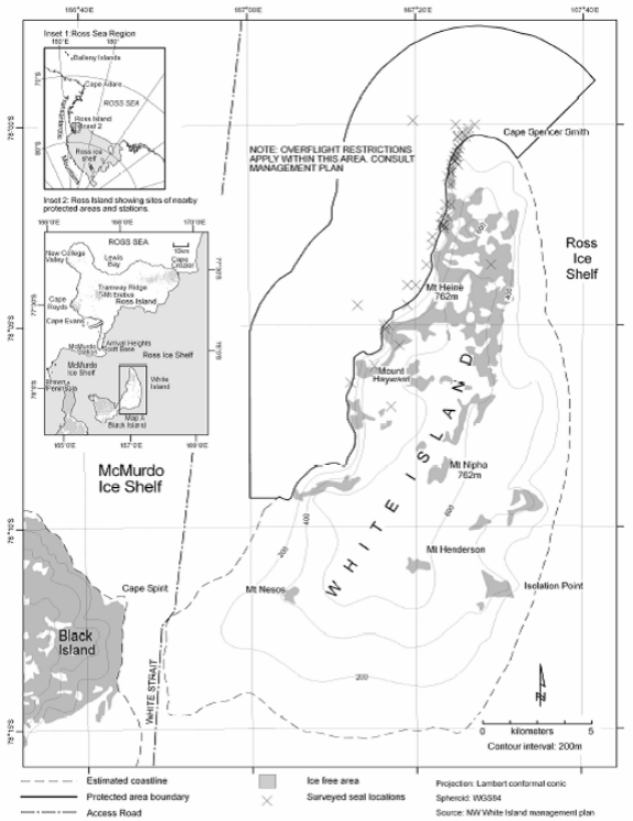
Part 37 Antarctic specially protected area No. 137
1 Name and location
North‑west White Island, McMurdo Sound.
Latitude 78 00 S, longitude 167 20 E.
2 Description
White Island, part of the McMurdo volcanic complex, is situated approximately 20 km south‑east of the edge of the McMurdo Ice Shelf and 25 km south‑east of Hut Point, the location of McMurdo Station (United States) and Scott Base (New Zealand) on Ross Island. The roughly triangular island is approximately 30 km long and 15 km wide at its maximum, and rises to a maximum elevation of 762 m in several locations.
The island is predominantly ice‑covered with most of the rock outcrops being in the north, and is completely surrounded by the permanent shelf ice, between 10 m and 100 m in thickness, of the McMurdo Ice Shelf and Ross Ice Shelf. Black Island is situated 2.5 km west of White Island, separated by the shelf ice of White Strait.
The Area includes 130 km2 of the shelf ice and open‑water cracks of both the Ross Ice Shelf and McMurdo Ice Shelf up to 5 km offshore north‑east, north and west from the White Island coast. The Area extends along the coast from a northern point on the east side of Cape Spencer‑Smith (78° 00 43 S, 167° 32 42 E) 19 km south to the southern‑most significant coastal outcrop of rock on the north‑west side of White Island (78° 09 08 S, 167° 05 00 E). At this southern point, the boundary extends approximately 1 km due west to 167° 00 00 E longitude, from where it extends due north to 78° 05 00 S latitude, after which the boundary continues north at a constant distance of 5 km from the shore of White Island to the eastern extremity of the Area at 77° 58 48 S, 167° 41 35 E. The White Island coast is distinguished by a change in surface slope where the transition between the floating ice‑shelf and land occurs: the transition is in some places gradual and indistinct, and the exact position of the coast is not precisely known. For this reason the coastal (generally east) boundary of the Area is considered to follow the line of the coast as evidenced by a surface elevation rise towards the land of 2 m above the average elevation of the adjacent McMurdo Ice Shelf.
3 Map
Part 38 Antarctic specially protected area No. 138
1 Name and location
Linnaeus Terrace, Asgaard Range, Victoria Land.
Latitude 77 35 50 S, longitude 161 05 00E.
2 Description
Linnaeus Terrace (77° 35 50 S, 161° 05 00 E) is an elevated bench of weathered Beacon Sandstone approximately 1.5 km in length and 1 km in width. It is located at the east end of the Asgaard Range, 1.5 km north of Oliver Peak (77 36 40 S, 161° 02 30 E) at an elevation of about 1 600 m. The Area overlooks the South Fork of the Wright Valley, is about 4 km from Don Juan Pond and 10 km from the terminus of the Wright Upper Glacier.
On the ground, the lower (northern) boundary of the Area is characterised by the presence of a predominantly sandstone outcrop of approximately 3 m in height which extends for much of the length of the terrace. The lower boundary of the Area is defined as the upper edge of this outcrop, and as straight lines adjoining the visible edges where the outcrop is covered by surface talus. The upper (southern) boundary of the Area is characterised by a line of sandstone outcrop of about 2–5 m in height, occurring between the elevations of 1 660–1 700 m about 70 m above the general elevation of the terrace. The upper boundary of the Area is defined as the uppermost edge of this outcrop, and shall be considered a straight line between the visible edges where the outcrop is covered by surface talus. The west end of the Area is defined as where the terrace narrows and merges with a dolerite talus slope on the flank of the north‑west ridge of Oliver Peak. The boundary at the west dips steeply from where the upper outcrop disappears, following the border of the dolerite talus with the terrace sandstone down to the western‑most corner. The east boundary is defined as the 1 615 m contour, which follows closely the edge of an outcrop which extends much of the width of the terrace. At the southern‑most corner of the Area the terrace merges with the slopes into the valley to the east: from this point the boundary extends upward to the 1 700 m contour, from where it follows the line of outcrop defining the south boundary.
3 Map
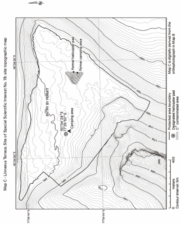
Note This map predates the current terminology — Site of Special Scientific Interest No. 19 is now ASPA No. 138.
Part 39 Antarctic specially protected area No. 139
1 Name and location
Biscoe Point, Anvers Island.
Latitude 64 49 S, longitude 63 49 W.
2 Description
Biscoe Point (latitude 64° 49 S, longitude 63° 49 W) is situated on the southeast side of Biscoe Bay on the south side of Anvers Island in the Palmer Archipelago off the mid‑west coast of the Antarctic Peninsula. The site includes the rocky promontory ending in Biscoe Point, the smaller headland immediately to the north and the small islet off the south‑west of Biscoe Point. A narrow area of land between the two promontories is included, as is the inshore marine environment within the site boundaries, which are shown on the map.
3 Map

Note This map predates the current terminology — SSSI No. 20 is now ASPA No. 139.
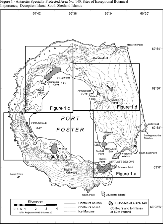
Part 40 Antarctic specially protected area No. 140
1 Name and location
Parts of Deception Island, South Shetland Islands.
6257 S Latitude, 6038 W longitude.
2 Description
Deception Island is an active volcano. Recent eruptions occurring in 1967, 1969 and 1970 (Baker et al. 1975) altered many of the topographical features of the island and created new, and locally transient, surfaces for the colonisation of plants and other terrestrial biota (Collins 1969, Cameron & Benoit 1970, Lewis Smith 1984a, b). There are a number of sites of geothermal activity, some with fumaroles (Smellie et al. 2002).
The flora of the island is unique in Antarctic terms, particularly where associated with these geothermal areas, but also because of the recently formed surfaces which provide known‑age habitats for the study of colonisation and other dynamic ecological processes by terrestrial organisms (Lewis Smith 1988).
Five small sites around the coast of Port Foster were adopted under Recommendation XIII–8 (ATCM XIII, Brussels, 1985) as Site of Special Scientific Interest No. 21 on the grounds that “Deception Island is exceptional because of its volcanic activity, having had major eruptions in 1967, 1969 and 1970. Parts of the island were completely destroyed, new areas were created, and others were covered by varying depths of ash. Few areas of the interior were unaffected. The island offers unique opportunities to study colonization processes in an Antarctic environment”.
Following a detailed botanical survey of the island in 2002, the values specified in the original designation were reaffirmed and considerably augmented. The survey identified 11 sub‑sites of unique botanical interest.
Those interests were:
The island has the greatest number of rare and extremely rare plant species of any site in the Antarctic. 28 of the 54 mosses recorded on the island, 4 of the 8 liverworts and 14 of the ca. 75 lichen are considered to be rare or extremely rare. Appendix A lists the plant species classed as rare or extremely rare in the Antarctic Treaty Area, which occur on Deception Island. These represent 25%, 17% and ca. 4% of the total number of mosses, liverworts and lichens, respectively, known from the Antarctic (Aptroot & van der Knaap 1993, Bednarek‑Ochyra et al. 2000, Ochyra et al. in press, Øvstedal & Lewis Smith 2001). Thirteen species of moss (including two endemics), 2 species of liverwort and 3 species of lichen growing on Deception Island have not been recorded elsewhere in the Antarctic. No other site in the Antarctic is comparable. This suggests that there is a significant deposition of immigrant propagules (by wind and seabirds), particularly of southern South American provenance, over the Antarctic, which becomes established only where favourable germinating conditions prevail (eg the heat and moisture provided around fumaroles) (Lewis Smith 1984a, b). Such sites are unique in the Antarctic Treaty Area.
The more stable geothermal areas, some of which have fumaroles issuing steam and sulphurous gas, have developed bryophyte communities of varying complexity and density, each with a distinct and unique flora. Most of these areas were created during the 1967–70 series of eruptions, but at least one (Mount Pond) predates that period. Species growing close to active vents are continuously subjected to temperatures between 30C to 50C, thereby posing important questions regarding their physiological tolerance.
Areas of volcanic ash, mudflows, scoria and lapilli deposited between 1967 and 1970 provide unique known‑age surfaces. These are currently being colonised by vegetation and other terrestrial biota, allowing the dynamics of immigration and colonisation to be monitored. These areas are unstable and subject to wind and water erosion, so exposing some areas to continual surface change and a cycle of re‑colonisation.
Kroner Lake, the only intertidal lagoon with hot springs in Antarctica, supports a unique community of brackish‑water algae.
Several sites within the Area, unaffected by ash deposits during the 1967–70 eruptions, support long‑established mature communities with diverse vegetation and are typical of the older stable ecosystems on the island.
The largest known stand of Antarctic pearlwort (Colobanthus quitensis), one of only two flowering plants in the Antarctic, is located within the Area. After being virtually eradicated by burial in ash during the 1967 eruption, it has recovered and is now spreading at an unprecedented rate within and beyond the original site. This correlates with the current trend in regional climate change, particularly increasing temperature.
3 Map
Part 41 Antarctic specially protected area No. 141
1 Name and location
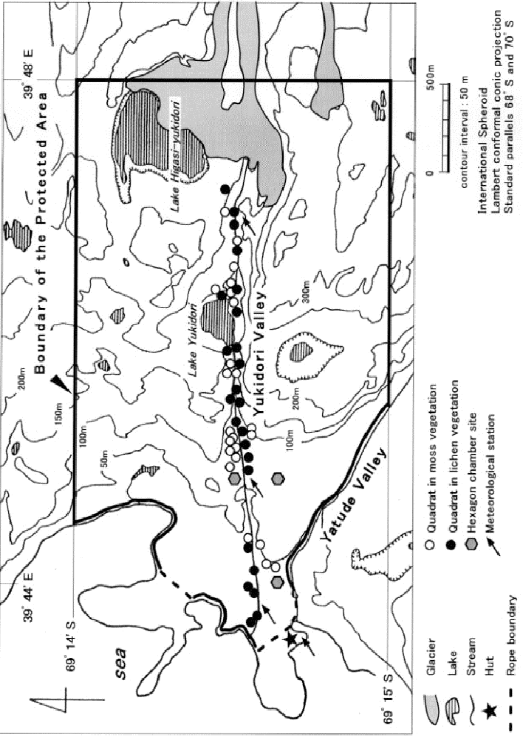
Yukidori Valley, Langhovde, Lützow‑Holmbukta.
Latitude 69 00 30 S, longitude 39 46 00 E.
2 Description
Yukidori Valley (69º 00 30 S, 39º 46 00 E) is situated in the middle part of Langhovde, on the east coast of Lützow‑Holm Bay, Continental Antarctica. The Area encompasses 2.0–2.5 km by 1.8 km, located between a tongue of the ice cap and sea at the western end of the Valley. The location of the Area and its boundaries are shown on the attached map. It is described as all the land within the Area bounded by the following coordinates:
69º 14 00 S, 39º 44 20 E
69º 14 00 S, 39º 48 00 E
69º 15 00 S, 39º 48 00 E
69º 15 00 S, 39º 45 20 E.
3 Map
Part 42 Antarctic specially protected area No. 142
1 Name and location
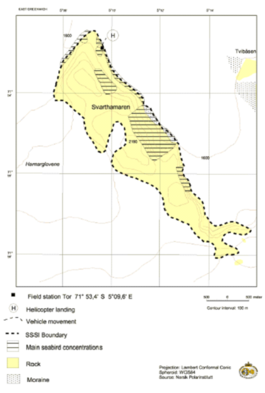
Svarthamaren, Mühlig‑Hofmannfjella, Dronning Maud Land.
Latitude 71 33 17 S to 71 55 58 S, longitude 5 09 12 E to 5 15 12 E.
2 Description
The Area is situated in Mühlig‑Hoffmannfjella, Dronning Maud Land, stretching from approximately 71º 33 17 S, 5º 09 12 E in the north‑west to approximately 71º 55 58 S, 5º 15 12 E in the south‑east. The distance from the ice front is about 200 km. The Area covers approximately 6.4 km2, and consists of the ice‑free areas of the Svarthamaren nunatak, including the areas in the immediate vicinity of the ice‑free areas naturally belonging to the nunatak (i.e. rocks).
The Norwegian field station Tor is located in the Svarthamaren nunatak at latitude 71 53 S, longitude 5 10 E. The station, including a 10 m buffer zone around the station buildings, is excluded from the Area.
3 Map
Note This map predates the current terminology — SSSI is now ASPA.
Part 43 Antarctic specially protected area No. 143
1 Name and location
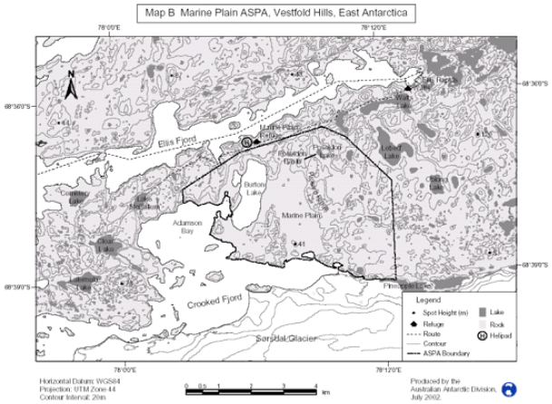
Marine Plain, Mule Peninsula, Vestfold Hills, Princess Elizabeth Land.
Latitude 68 37 50 S, longitude 78 07 55 E.
2 Description
Marine Plain ASPA lies approximately 10 km south‑east of Davis Station in the Vestfold Hills. The Area (23.4 km², 68° 37 50 S, 78° 07 55 E) opens into an arm of Crooked Fjord on the southern side of Mule Peninsula, the southern‑most of the three major peninsulas that comprise the Vestfold Hills. The Vestfold Hills are a largely ice‑free oasis of approximately 512 km² of bedrock, glacial debris, lakes, and ponds, at the eastern side of Prydz Bay, Princess Elizabeth Land.
Starting at the most northerly point of the Area the boundary description is as follows: commencing at 68° 36 34 S, 78° 09 28 E, then south‑easterly to 68° 36 45 S, 78° 10 30 E; then south‑easterly to 68° 37 30 S, 78° 12 30 E, then south along meridian of longitude 78° 12 30 E to its intersection with the northern shore of Pineapple Lake; then west along that shore to the edge of the Sørsdal Glacier; then westerly along the northern edge of the Sørsdal Glacier to its intersection with the low water mark of the north eastern shore of Crooked Fjord; then westerly along the low water mark of the northern shore of Crooked Fjord (cutting across the outlet of Burton Lake into Crooked Fjord) to its intersection with the meridian of longitude 78° 03 00 E; then north along meridian of longitude 78° 03 00 E to its intersection with the parallel of latitude 68° 37 30 S, then north‑easterly to 68° 36 56 S, 78° 05 39 E, then north‑easterly to the point of commencement.
3 Map
Part 44 Antarctic specially protected area No. 144
Note The declaration of this area as an Antarctic specially protected area ceases to have effect at the end of 31 December 2010 — see section 6.
1 Name
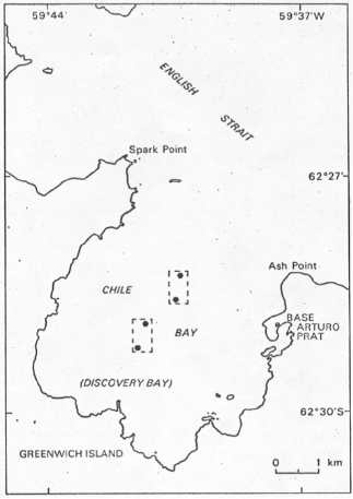
Chile Bay (Discovery Bay), Greenwich Island, South Shetland Islands.
2 Description
The site comprises two small areas of benthic habitat in Chile Bay located as follows:
Benthic habitat A — between 50 and 100 m depths and the following coordinates: latitude 62° 28.9 S, longitude 59° 41 12 W; latitude 62° 29 3 S, longitude 59° 41 43 W;
Benthic habitat B — between 100 and 200 m depths and between the following coordinates: latitude 62° 28.3 S, longitude 59° 40 15 W; latitude 62° 28.7 S, longitude 59° 40 47 W.
3 Map
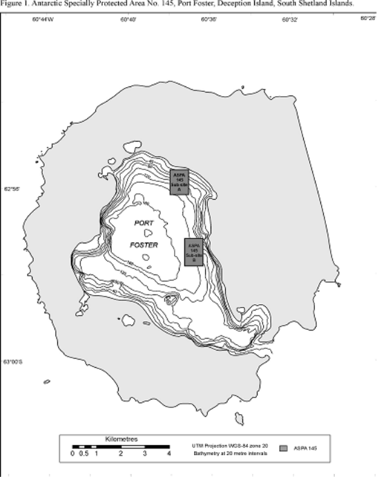
Part 45 Antarctic specially protected area No. 145
1 Name and location
Port Foster, Deception Island, South Shetland Islands
A: between 62° 55 30 S and 62° 56 12 S, and between 60° 37 00 W and 60° 38 00 W
B: between 62° 57 12 S and 62° 57 54 S, and between 60° 36 20 W and 60° 37 20 W.
2 Description
Values protected under original designation included the diversity of benthic fauna on two different kinds of sea bottom substrates. The original research about the ecological process of recolonisation after volcanic eruption needed protection from the risk of undue interference.
Deception Island is a caldera formed by subsidence of a group of Cenozoic volcanoes superimposed along radial faults. Port Foster is an almost entirely enclosed body of water, receiving large volumes of fresh water during periods of melt. In several places there is geothermal activity.
The area is of exceptional ecological interest because of its actively volcanic character. The two habitat areas are subject to long‑term research programs and the purpose in designating them is, as far as possible, to reduce the risk of accidental interference that could jeopardise these scientific investigations.
 3 Map
3 Map
Part 46 Antarctic specially protected area No. 146
Note The declaration of this area as an Antarctic specially protected area ceases to have effect at the end of 31 December 2010 — see section 6.
1 Name and location
South Bay, Doumer Island, Palmer Archipelago.
Latitude 64 51 42 S to 64 51 58 S, longitude 63 34 00 W to 63 35 20W.
2 Description
Doumer Island lies at the south‑west entrance to Neumayer Channel. It is separated from Wiencke Island by the Peltier Channel. South Bay lies on the south coast of Doumer Island. The site consists of a small area of coastal and sub‑tidal benthos down to 45 m depth as follows: latitude 64° 51 42 S to the north, between longitude 63° 34 00 W and longitude 63° 35 20 W, and to the south by a diagonal line that starts at a point 100 m north of the Refuge (Sub‑base Yelcho) on the southern shore of South Bay and extends to latitude 64° 51 58 S and longitude 63° 34 00 W.
3 Map
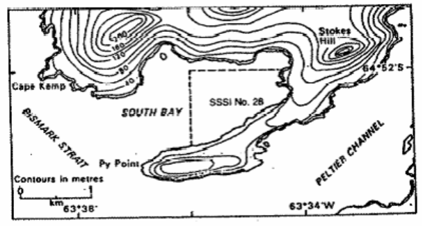
Note This map predates the current terminology — SSSI No. 28 is now ASPA No. 146.
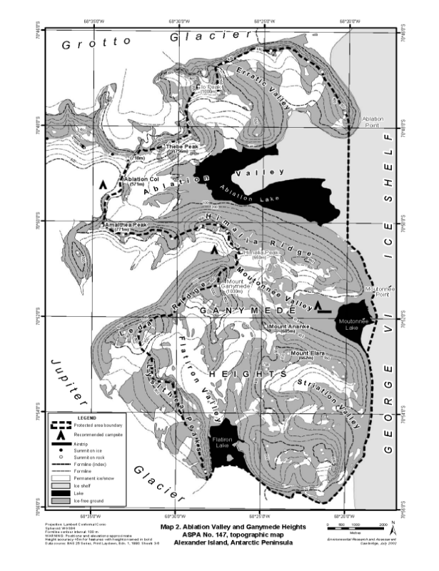
Part 47 Antarctic specially protected area No. 147
1 Name and location
Ablation Valley‑Ganymede Heights, Alexander Island.
Latitude 70 45 S to 70 55 S, longitude 68 21 W to 68 40 W.
2 Description
Ablation Valley‑Ganymede Heights (between latitudes 70° 45 S and 70° 55 S and longitudes 68° 21 W and 68° 40 W, approximately 180 km2) is situated on the east side of Alexander Island, the largest island off the western coast of Palmer Land, Antarctic Peninsula. The Area has a central west‑east extent of about 10 km and a north‑south extent of about 18 km, flanked to the west by the upper part of Jupiter Glacier, to the east by the permanent ice shelf in George VI Sound, to the north by Grotto Glacier and to the south by the lower reaches of Jupiter Glacier.
The designated Area comprises the entire Ablation Valley‑Ganymede Heights massif, bounded in the west by the principal ridge dividing Jupiter Glacier from the main Ablation‑Moutonnée‑Flatiron valleys. In the east, the boundary is defined by the western margin of George VI Ice Shelf. The northern boundary of the Area is defined as the principal ridge dividing Grotto Glacier from Erratic Valley and other tributary valleys feeding into Ablation Valley, immediately to the south. In the north‑west of the Area, the boundary extends across the mostly‑glaciated col separating upper Jupiter Glacier from Ablation Valley. The southern boundary of the Area, from east of the principal ridge on the west side of Flatiron Valley to where Jupiter Glacier joins George VI Ice Shelf, is defined as the northern lateral margin of Jupiter Glacier. As the margin between Ablation Lake and George VI Ice Shelf is in places indistinct, the eastern boundary of the Area at Ablation Valley is defined as a straight line extending due south from the eastern extremity of Ablation Point to where the ice shelf abuts land, and from where the eastern boundary follows the land/ice shelf margin. The physiography is similar further south at Moutonnée Lake, and the eastern boundary in this locality is defined as a straight line extending from the eastern extremity of the point on the northern side of (and partially enclosing) Moutonnée Lake to the locality of a prominent meltwater pool where the ice shelf abuts land, and from where the boundary follows the land/ice shelf margin south to where Jupiter Glacier and George VI Ice Shelf adjoin. The Area thus includes the entirety of Ablation and Moutonnée lakes and those parts of the ice shelf behind which they are impounded.
3 Map
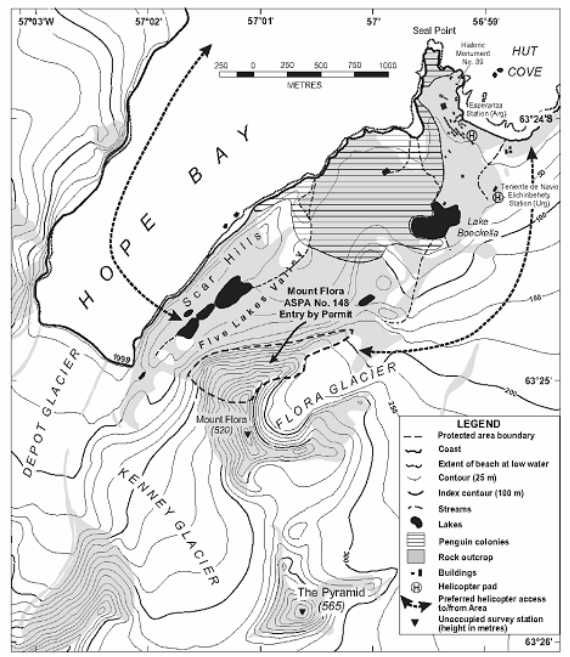
Part 48 Antarctic specially protected area No. 148
1 Name and location
Mount Flora, Hope Bay, Antarctic Peninsula.
Latitude 63 25 S, longitude 57 01 W.
2 Description
Mount Flora (latitude 63° 25 S, longitude 57° 01 W, 0.3 km2) is situated on the south‑eastern flank of Hope Bay, at the northern end of Trinity Peninsula, Antarctic Peninsula. The summit of Mount Flora (520 m) is approximately 1 km from the southern shore of Hope Bay.
The boundaries designated in the original management plan have been revised in the current management plan to include all of the known exposed fossiliferous strata on the northern slopes of Mount Flora. The summit ridge and highest peak of Mount Flora (520 m), which were formerly within the boundary, are comprised of non‑fossiliferous volcanic rocks and have now been excluded from the Area. The boundary runs from the north summit of Mount Flora (516 m) — the highest point of the boundary — westward down the ridge to the Kenney Glacier, the eastern margin of Kenney Glacier northward to the 150 m contour, eastward along the 150 m contour to the north‑western margin of the Flora Glacier, the north‑western margin of the Flora Glacier south‑westward to the ridge leading westward to the north summit of Mount Flora. Where present, the glacier margins, lower outcrops, western ridge and northern summit of Mount Flora form visually obvious features that indicate the boundaries: the Area remains otherwise unmarked.
3 Map
Part 49 Antarctic specially protected area No. 149
1 Name and location
Cape Shirreff and San Telmo Island, Livingston Island, South Shetland Islands.
Latitude 62 29 S, longitude 60 48 W.
2 Description
Following designation, the size of the Cape Shirreff Antarctic fur seal colony increased to a level at which biological research could be undertaken without threatening continued increase. A survey of the South Shetland Islands and the Antarctic Peninsula identified Cape Shirreff — San Telmo Island as the most suitable site to monitor Antarctic fur seal colonies that could be affected by fisheries around the South Shetland Islands. In order to accommodate the monitoring program the SPA was redesignated as Site of Special Scientific Interest (SSSI) No. 32 through Recommendation XV‑7 (1989) following a joint proposal by Chile, the United Kingdom and the United States of America. Designation was on the grounds that the “presence of both Antarctic fur seal and penguin colonies, and of krill fisheries within the foraging range of these species, make this a critical site for inclusion in the ecosystem monitoring network being established to help meet the objectives of the Convention on the Conservation of Antarctic Marine Living Resources (CCAMLR). The purpose of the designation is to allow planned research and monitoring to proceed, while avoiding or reducing, to the greatest extent possible, other activities which could interfere with or affect the results of the research and monitoring programme or alter the natural features of the Site”. The boundaries were enlarged to include San Telmo Island and associated nearby islets. Following a proposal prepared by Chile and USA, the Area was subsequently designated as CCAMLR Ecosystem Monitoring Program (CEMP) Site No. 2 through CCAMLR Conservation Measure 82/XIII (1994), with boundaries identical to SSSI No. 32.
The current Management Plan reaffirms the exceptional scientific and monitoring values associated with the large and diverse populations of seabirds and pinnipeds which breed within the Area, and in particular those of the Antarctic fur seal colony. The Antarctic fur seal colony is the largest in the Antarctic Peninsula region and is the most southerly that is large enough to study growth, survival, diet, reproduction parameters: it numbered around 20,000 individuals in 2003–2004. Monitoring of the Antarctic fur seal colony began in 1965 (Aguayo and Torres, 1966; 1967) and seasonal data are available from 1991, making this one of the longest continuous Antarctic fur seal monitoring programs. As part of the CEMP, monitoring is established to detect and avoid possible adverse effects of fisheries on dependant species such as pinnipeds and seabirds, as well as target species such as Antarctic krill (Euphausia superba). Long‑term studies are assessing and monitoring the survival, feeding ecology, growth, condition, reproduction, behavior, vital rates, and abundance of pinnipeds and seabirds that breed within the Area. Data from these studies will be compared alongside environmental and other biological data and fisheries statistics in order to help identify possible cause‑effect relationships between fisheries and pinniped and seabird populations.
In 2001–02 imprints of megaflora were discovered in rocks incorporated within moraines of the Livingston Island glacier (Palma‑Heldt et al., in review 2004). The fossiliferous rocks are of two different ages, and early interpretations suggest the rocks may assist understanding relationships between nearby fossil localities at Williams Point and Byers Peninsula, also on Livingston Island. Studies of the fossils are on‑going and it is important that they are protected from over‑sampling.
The original values of the protected area associated with the plant and invertebrate communities cannot be confirmed as primary reasons for special protection of the Area because there is a lack of data available describing the communities.
3 Map
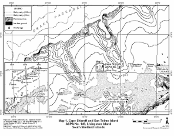
Part 50 Antarctic specially protected area No. 150
Note The declaration of this area as an Antarctic specially protected area ceases to have effect at the end of 31 December 2010 — see section 6.
1 Name and location
Ardley Island, Maxwell Bay, King George Island.
Latitude 62 13 S, longitude 58 54 W.
2 Description
Ardley Island (62° 13 S, 58° 54 W) is situated about 500 m east of the coast of Fildes Peninsula, Maxwell Bay, King George Island. It is about 1 km south‑east of the Soviet station Bellingshausen and the Chilean station Teniente Marsh, and about 0.5 km east of the Chinese station Great Wall.
The site comprises the entire island and its associated littoral zone, including the isthmus between the island and Fildes Peninsula to the west. The island is about 2.0 km long and 1.5 km at its widest, and rises to about 50 m altitude.
3 Map
Note This map predates the current terminology — SSSI No. 33 is now ASPA No. 150.
Part 51 Antarctic specially protected area No. 151
1 Name
Lions Rump, King George Island, South Shetland Islands.
2 Description
The site is located on the southern coast of King George Bay, King George Island, in the South Shetlands Islands. It is described as all the land and sea falling within the area bounded by the following coordinates:
62° 07 48 S, 58° 09 17 W
62° 07 49 S, 58° 07 14 W
62° 08 19 S, 58° 07 19 W
62° 08 16 S, 58° 09 15 W.
The Area includes the littoral and sublittoral zones extending from the eastern end of Lajkonik Rock to the most northerly point of Twin Pinnacles. From this point the boundary extends to the eastern‑most end of the columnar plug of Lions Head to the east of White Eagle Glacier. On land, the Area includes the coast of raised beaches, freshwater pools and streams on the south side of King George Bay, around Lions Cove, and the moraines and slopes which lead to the lower ice tongue of White Eagle Glacier, then westward to a small moraine which protrudes through the ice cap south‑east of Sukiennice Hills.
3 Map
Note This map predates the current terminology — SPA is now ASPA.
Part 52 Antarctic specially protected area No. 152
1 Name and location
Western Bransfield Strait off Low Island, South Shetland Islands.
Latitude 63 15 S to 63 30 S, longitude 62 00 W to 62 45 W.
2 Description
Bransfield Strait is a deep water passage approximately 220 km long and 120 km wide between the Antarctic Peninsula and the numerous islands that comprise the South Shetland Islands. The Drake Passage is to the north and to the west is the Bellingshausen Sea. The Area lies approximately 80 km west of the Antarctic Peninsula, mostly within the 200 m isobath directly south and west of Low Island. Low Island is the southern‑most of the South Shetland Islands, lying 60 km south‑west of Deception Island and 25 km south‑east of Smith Island. To the west and south of Low Island, and for approximately 20 km from the shore, the sea floor slopes gently from the intertidal zone to depths of approximately 200 m. The sea floor slopes steeply to the east of Low Island, reaching depths of up to 1 200 m in this part of Bransfield Strait.
The revised boundaries of the Area at Western Bransfield Strait are defined in the north as the line of latitude at 63° 15 S and in the south at 63° 30 S, in the east the boundary is defined as the line of longitude at 62° 00 W and in the west 62° 45 W. The north‑eastern boundary is defined as the shoreline of Low Island, extending from 62° 00 W, 63° 20 S in the south‑east (approximately 2 km from Cape Hooker) to 62° 13 30 W, 63° 15 S in the north‑west (Cape Wallace). The coastline boundary on the western and southern shores of Low Island is defined as the high tide level, and the intertidal zone is included within the Area. The Area extends a maximum of 27.6 km north‑south and a maximum of 37.15 km east‑west, encompassing an area of approximately 900 km². Boundary markers have not been installed because in the marine area this is impractical, while at Low Island the coast itself is a clearly defined and visually obvious boundary feature.
3 Map
Part 53 Antarctic specially protected area No. 153
1 Name and location
Eastern Dallmann Bay off Brabant Island, Palmer Archipelago.
Latitude 63 53 S to 64 20 S, longitude 62 16 W to 62 45 W.
2 Description
Dallmann Bay (between latitudes 63° 53 S and 64° 20 S and from longitude 63° 16 W eastward to the western shore of Brabant Island) is situated approximately 65 km west of the Antarctic Peninsula, between Brabant Island and Anvers Island, with Bransfield Strait to the north and Gerlache Strait to the south.
The designated Area is defined in the south by latitude 64° 20 S, extending from Fleming Point westward for 2 km to 62° 40 W. From this location, the western boundary extends due north on longitude 62° 40 W for 18.5 km to 64° 10 S, south‑south‑west of Astrolabe Needle. The western boundary then extends north‑north‑west almost 19 km to 62° 45 W, 64° 00 S. The western boundary then extends approximately 13 km due north on longitude 62° 45 W to latitude 63° 53 S, the northern boundary of the Area. The northern boundary extends along latitude 63° 53 S from 62° 45 W to 62° 16 W, being a distance of approximately 23.4 km. The eastern boundary extends due south approximately 16 km from 62° 16 W, 63° 53 S to the eastern extremity of Pasteur Peninsula, Brabant Island, at 62° 16 W, 64° 02 S. From there, the eastern boundary is defined as the mean high water mark of the northern and western coastline of Brabant Island, which includes the intertidal zone within the Area. The Area is 50 km from north to south and extends up to a maximum of 23.4 km east‑west. West of Brabant Island the width of the Area ranges between 10 km (at Guyou Bay) and 1.5 km (near Claude Point). The total area is approximately 580 km2.
3 Map
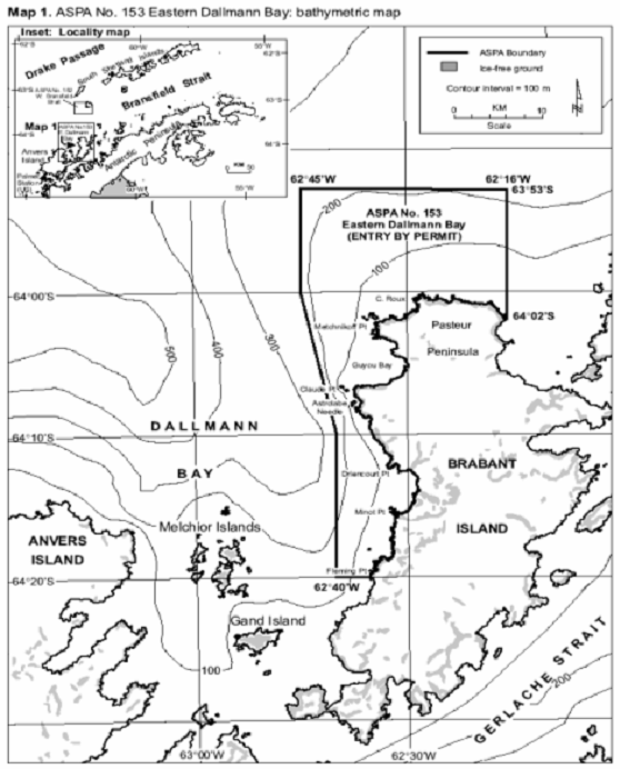
Part 54 Antarctic specially protected area No. 154
1 Name and location
Botany Bay, Cape Geology, Victoria Land.
Latitude 77 00 14 S, longitude 162 32 52 E.
2 Description
Cape Geology is situated in the south‑western corner of Granite Harbour, southern Victoria Land, at 77° 00 14 S, 162° 32 52 E approximately 100 km north‑west of Ross Island.
The north‑west corner of the Area is marked by a brass plaque in a boulder (M1, 2 m) 400 m south‑west of Cape Geology. The west boundary is defined by a line extending first 260 m south‑south‑east from M1 to a large boulder (marked by a cairn) with terrier bolt (M2) at an elevation of 118 m on the ridge above the campsite; thence the boundary extends 250 m up this ridge to a point at 162 m elevation marked by an iron tube with bamboo pole. The west boundary extends a further 300 m up this ridge to a large pointed rock at 255 m elevation near the edge of the permanent ice field. The boundary then extends 150 m south across the ice field to the west edge of a prominent line of exposed rock and moraine in the south‑west corner of the Area at 325 m elevation. The south boundary follows this line of rock east until the exposure is buried by the ice field, thence south‑east across the ice field for 500 m to the edge of a second and more prominent exposure at an elevation of just over 400 m (M3). The boundary follows the upper edge of this exposure and then crosses the ice field south‑east to an elevation of approximately 325 m where the ice‑free eastern boundary ridge and the ice field converge. The east boundary follows the ridge crest for 1 550 m in a north‑east direction to a large pointed rock on the ridge (M4, 392 m) where the east boundary turns to descend due north to the coast at the eastern extremity of the boulder beach of Botany Bay (M5, 5 m). The mean high water mark of the coastline of Botany Bay and Cape Geology forms the northern boundary of the Area.
3 Map

Part 55 Antarctic specially protected area No. 155
1 Name and location
Cape Evans, Ross Island.
7738 S Latitude, 16624 E longitude.
2 Description
The significant historic value of this Area was formally recognised when it was listed as Historic Site and Monument Nos 16 and 17 in Recommendation 9 (1972). An area containing both sites was designated as Specially Protected Area No. 25 in Measure 2 (1997) and redesignated as Antarctic Specially Protected Area 155 in Decision 1 (2002).
The Terra Nova hut (Historic Site and Monument No. 16) is the largest of the historic huts in the Ross Sea region. It was built in January 1911 by the British Antarctic Terra Nova Expedition of 1910–1913, led by Captain Robert Falcon Scott, RN. It was subsequently used as a base by the Ross Sea party of Sir Ernest Shackleton’s Imperial Trans‑Antarctic Expedition of 1914–1917.
Historic Site and Monument No. 17 contains the Cross on Wind Vane Hill, (erected in the memory of three members of Shackleton’s Ross Sea party who died in 1916). In addition to this, the anchors of the ship Aurora from the Imperial Trans‑Antarctic Expedition, an instrument shelter, several supply dumps and dog kennels, and numerous artefacts are distributed around the site.
Some of the earliest advances in the study of earth sciences, meteorology, flora and fauna are associated with the Terra Nova Expedition based at this site. The data collected can provide a bench mark against which to compare current measurements. The history of these activities and the contribution they have made to the understanding and awareness of Antarctica therefore contribute to both the historic and scientific value of the site.
The Cape Evans site is one of the principal sites of early human activity in Antarctica. It is an important symbol of the ‘Heroic Era’ of Antarctic exploration, and as such, has considerable historical significance.
3 Map
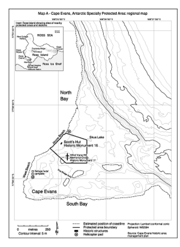
Part 56 Antarctic specially protected area No. 156
1 Name and location
Lewis Bay, Mount Erebus, Ross Island.
Latitude 77 25 29 S, longitude 167 28 30 E.
2 Description
The designated Area on Ross Island encompasses the crash zone (centred on 77° 25 29 S, 167° 28 30 E, elevation 520 m) and the surrounding glacial ice 2 km above and to either side of this position, extends as a 4 km wide ‘rectangle’ down to the sea, and includes the airspace above this region to an altitude of 1 000 m with the exception of a 200 m wide air access ‘corridor’ along the coastline. The west boundary of the Area is the 167° 23 33 E meridian; the east boundary is the 167° 33 27 E meridian. The south boundary is the 77° 26 33 S parallel, while the north boundary is defined by the coastline.
3 Map
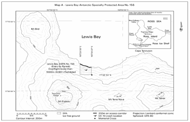
Part 57 Antarctic specially protected area No. 157
1 Name and location
Backdoor Bay, Cape Royds, Ross Island.
7733 10.7 S Latitude, 16610 6.5 E longitude.
2 Description
The significant historic value of this Area was formally recognised when it was listed as Historic Site and Monument No. 15 in Recommendation 9 (1972). It was designated as Specially Protected Area No. 27 in Measure 1 (1998) and redesignated as ASPA No. 157 in Decision 1 (2002).
The hut on which this Area is centred was built in February 1908 by the British Antarctic (Nimrod) Expedition of 1907–1909 which was led by Sir Ernest Shackleton. It was also periodically used by the Ross Sea Party of Shackleton’s Imperial Trans‑Antarctic Expedition of 1914–1917.
Structures associated with the hut include stables, kennels, a latrine and a garage created for the first motor vehicle in Antarctica. Other significant relics in the Area include an instrument shelter, supply depots, and a rubbish site. Numerous additional artefacts are distributed around the Area.
Cape Royds is one of the principal areas of early human activity in Antarctica. It is an important symbol of the ‘Heroic Era’ of Antarctic exploration and, as such, has considerable historical significance. Some of the earliest advances in the study of earth sciences, meteorology, flora and fauna in Antarctica are associated with the Nimrod Expedition which was based at this site. The history of these activities and the contribution they have made to the understanding and awareness of Antarctica give this Area significant scientific, aesthetic and historic values.
3 Map
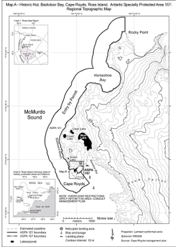
Part 58 Antarctic specially protected area No. 158
1 Name and location
Hut Point, Ross Island.
Latitude 77 50 50 S, longitude 166 38 E.
2 Description
The significant historic value of this Area was formally recognised when it was designated as Historic Site and Monument No. 18 in Recommendation 9 (1972). It was designated as Specially Protected Area No. 28 in Measure 1 (1998) and redesignated as ASPA No. 158 in Decision 1 (2002).
The hut was built in February 1902 during the National Antarctic (Discovery) Expedition of 1901–1904, led by Captain Robert Falcon Scott who later found it a valuable advance staging point for journeys on the “Barrier” during his 1910‑1913 expedition. It was also used by Sir Ernest Shackleton during the 1907‑1909 British Antarctic Expedition and later by his stranded Ross Sea Party during the Imperial Trans‑Antarctic Expedition of 1914–1917. This building was prefabricated in Australia to an ‘outback’ design with verandahs on three sides.
The Hut Point site is one of the principal sites of early human activity in Antarctica. It is an important symbol of the ‘Heroic Era’ of Antarctic exploration and, as such, has considerable historical significance. Some of the earliest advances in the study of earth sciences, meteorology, flora and fauna in Antarctica are associated with the Discovery Expedition based at this site. The history of these activities and the contribution they have made to the understanding and awareness of Antarctica give this Area significant scientific, aesthetic and historic values.
3 Map
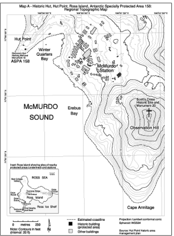
Part 59 Antarctic specially protected area No. 159
1 Name and location
Cape Adare, Borchgrevink Coast, Northern Victoria Land.
Eastern longitudes 11° 22 40 and 11° 54 20
Southern latitudes 70° 43 50 and 70° 46 40
2 Description
The historic value of this Area was formally recognised when it was listed as Historic Site and Monument No. 22 in Recommendation VII‑9 (1972). It was designated as Specially Protected Area No. 29 in Measure 1 (1998) and redesignated as ASPA No. 159 in Decision 1 (2002).
There are three main structures in the Area. Two were built in February 1899 during the British Antarctic (Southern Cross) Expedition led by C. E. Borchgrevink (1898–1900). One hut served as a living hut and the other as a store. They were used for the first winter spent on the Antarctic continent.
Scott’s Northern Party hut is situated 30 m to the north of Borchgrevink’s hut. It consists of the collapsing remains of a third hut built in February 1911 for the Northern Party led by V. L. A. Campbell of R. F. Scott’s British Antarctic (Terra Nova) Expedition (1910–1913), which wintered there in 1911.
In addition to these features there are numerous other historic relics located in the Area. These include stores depots, a latrine structure, two anchors from the ship Southern Cross, an ice anchor from the ship Terra Nova, and supplies of coal briquettes. Other historic items within the Area are buried in guano.
Cape Adare is one of the principal sites of early human activity in Antarctica. It is an important symbol of the ‘Heroic Era’ of Antarctic exploration and, as such, has considerable historical significance. Some of the earliest advances in the study of earth sciences, meteorology, flora and fauna in Antarctica are associated with the two earliest expeditions based at this site. The history of these activities and the contribution they have made to the understanding and awareness of Antarctica give this Area significant scientific, aesthetic and historic values.
3 Map
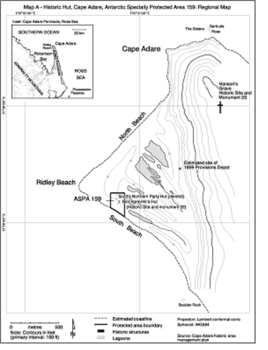
Part 60 Antarctic specially protected area No. 160
1 Name and location
Frazier Islands, Windmill Islands, Wilkes Land, East Antarctica.
Latitude 66° 14 S, longitude 110° 10 E.
2 Description
The Frazier Islands are located at latitude 66° 14 S, longitude 110° 10 E. The three islands (Nelly, Dewart and Charlton Islands) lie in the eastern part of Vincennes Bay approximately 16 km to the west‑north‑west of Casey Station.
The ASPA comprises the entire terrestrial area of the three islands, with the seaward boundary at the low water mark. The total area of the Frazier Islands ASPA is approximately 0.6 km². There are no boundary markers.
3 Map
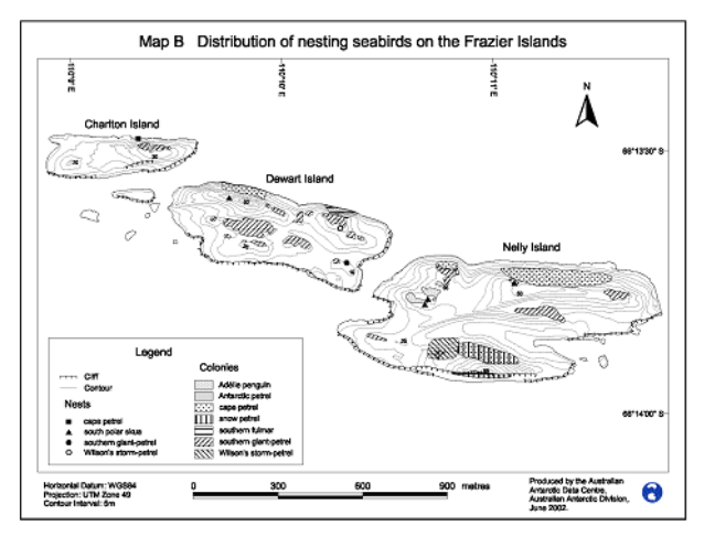
Part 61 Antarctic specially protected area No. 161
1 Name and location
Terra Nova Bay, Ross Sea.
Latitude 74 42 57 S to 74 48 00 S, longitude 164 10 00 E.
2 Description
The designated Area is situated in Terra Nova Bay, between the Campbell Glacier Tongue and Drygalski Ice Tongue, Victoria Land. The Area is confined to a narrow strip of coastal waters to the south of Terra Nova Bay Station (Italy), extending approximately 9.4 km in length and generally within 1.5–7 km of the shore, comprising an area of 29.4 km².
The western boundary of the Area is defined as the mean high water mark along the coastline extending between 74° 42 57 S in the north (2.3 km south of Terra Nova Bay Station) and 74° 48 00 S in the south (the southern shore of Adélie Cove), and includes the intertidal zone. The northern boundary of the Area is defined as the 74° 42 57 S line of latitude, extending from the coast 1.55 km eastward to the 164° 10 00 E line of longitude. The boundary position may be recognised near the shore by the presence of a large and distinctive offshore rock in the northernmost cove on the coast south of Terra Nova Bay Station, which is an unique feature on this stretch of coast. The southern boundary is defined as the 74° 48 00 S line of latitude, extending from the coast 3.63 km eastward to the 164° 10 00 E line of longitude. The boundary position may be recognised visually as being at the southern shore of the mouth of Adélie Cove, immediately south of a distinctive rocky outcrop at the base of the coastal cliffs. The eastern boundary of the Area is defined as the 164° 10 00 E line of longitude extending between 74° 42 57 S in the north and 74° 48 00 S in the south.
3 Map
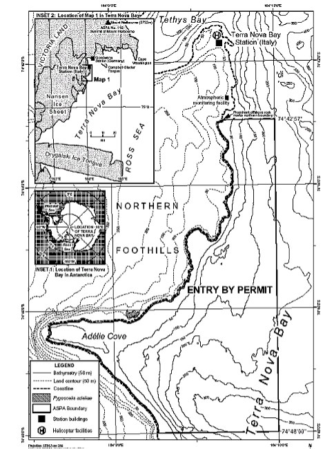
Part 62 Antarctic specially protected area No. 162
1 Name and Location
Mawson’s Huts, Cape Denison, Commonwealth Bay, George V Land, East Antarctica.
Latitude 67º0030S, longitude 142º3940E.
2 Description
Historic value
Mawson’s Huts at Cape Denison, Commonwealth Bay, was the main base of the Australasian Antarctic Expedition (AAE) of 1911–14, led by Dr Douglas Mawson. It is one of only six hut sites in Antarctica remaining from the ‘Heroic Era’.
Mawson’s Huts is one of a group of ‘Heroic Era’ huts where pragmatic consideration of the need to provide permanent shelter in the Antarctic environment resulted in an expedition hut form suitable for polar regions.
Mawson’s Huts were built in January, February and March 1912 and May 1913. In their surviving form and setting the huts illustrate the isolation and harsh environment of Cape Denison. They also demonstrate the cramped internal conditions endured by expedition members. The living quarters in the Main Hut, for example, a single space measuring 7.3 m by 7.3 m, provided sleeping and kitchen facilities for 18 men.
The external form and internal structure of the largest hut, the Main Hut, are a simple but strong architectural concept: a square base topped by a pyramid roof (to prevent damage by blizzards), with skylights to provide natural lighting. Following the decision to combine two expedition bases into one, a hip‑roofed accommodation hut measuring 5.5 m by 4.9 m was adjoined to the living quarters and equipped as a workshop. A 1.5 m wide verandah surrounded the structure on three sides, under the same roof. The verandah was used as a storage space that also assisted in insulating the hut from the weather.
The two huts that form the Main Hut were built of Oregon timber frames clad with Baltic pine tongue‑and‑groove boards. They were prefabricated in Australia, and on‑site construction was assisted by a branded letter code on framing members and coded colours painted on board ends. (None of the expedition party had any previous construction experience). The survival of the Main Hut at one of the windiest sites on Earth is testimony to the strength of its design and care of its construction.
Mawson’s Huts contain numerous significant and relatively untouched artefacts from the ‘Heroic Era’, which form a rich resource of material available for research and interpretation, and potentially yielding information about aspects of expeditioner life not included in official written accounts.
The three other AAE huts are:
The Absolute Magnetic Hut was constructed during February 1912. It measured 1.8 m by 1.8 m in plan with a skillion roof and had an Oregon timber frame to which boards of remnant timber were fixed. The hut was used in association with, and as a reference point for, observations made in the Magnetograph House. Today is it considered to be a standing ruin.
The Magnetograph House was erected in March 1912 to house equipment used to measure variations in the South Magnetic Pole. It measures 5.5 m by 2 m with a shallow pitched skillion roof and no windows. After the first building attempt was demolished by high winds, large rocks were heaped against the new hut to provide a wind barrier. Sheepskin and hessian attached to the roof also assisted in keeping the internal temperature constant and in minimising the ingress of drift snow. These innovations may have contributed to the relatively intact condition of the hut today.
Construction of the Transit Hut commenced in May 1913, with packing case timbers being affixed to an Oregon frame. The structure was also clad in sheepskin and canvas. Originally known as the Astronomical Observatory, the hut housed the theodolite used to take star sights to determine the exact longitude of Cape Denison. It is now considered to be a standing ruin.
Aesthetic value
Mawson’s Huts are of aesthetic value. The building form of the huts themselves shows the functional and efficient planning that was undertaken in response to the site position and the elements endured by the expedition members. The weathering of the huts and the decay of the remains gives a feeling of time elapsed and exposure to the elements.
3 Map
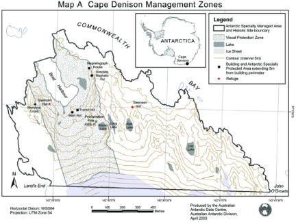
Part 63 Antarctic specially protected area No. 163
1 Name and Location
Dakshin Gangotri Glacier, Dronning Maud Land.
Latitude 7043 50 S, longitude 7046 40 E.
2 Description
Historic value
Dakshin Gangotri Glacier is a small tongue of polar continental ice sheet, overriding the Schirmacher Oasis of central Dronning Maud Land (CDML). It was identified by the second Indian Antarctic Expedition in 1983 and since then its snout is being monitored continuously.
Scientific value
With the availability of this vast amount of data for the past two decades, it has become a valuable site for observing the changes in the movement of the Antarctic ice sheet under the impact of global warming. The area has primary scientific importance for glaciologists and environmental scientists. Due to the scientific values of the Area and the nature of the research, it is protected as an Antarctic Specially Protected Area consistent with Articles 2, 3, 5 and 6 of Annex V of the Protocol on Environmental Protection to the Antarctic Treaty, to prevent interference with ongoing planned scientific investigations.
Environmental value
In the designated Area exploration shows the faunal diversity and ecology of the moss‑inhabiting terrestrial invertebrate fauna and it is also extensively explored lichenologically. Schirmacher Oasis is also important area for the algal and cyanobacterial flora diversity. Terrestrial mosses are quite widespread in the Schirmacher Oasis colonising a range of habitats. The bryophytes, because of their poikilohydric nature and alternative strategy of adaptation, are one of the very few plant groups which grow in Antarctica. As such their role in habitat modification, nutrient cycling, primary production and providing shelter and security to associated invertebrate animals, for example the bryobionts, bryophiles, bryoxenes assume a particular significance. Bryophytes have been reported in Schirmacher Oasis (divided in Eastern, Central and Western Schirmacher). Lichens, fungi, algae and bacteria have also been reported in the Area. Distribution of algae and cyanobacteria flora of fresh water streams of the Oasis at the designated area are studied. Examination of algae and cyanobacteria is conducted in the glacier‑melt water stream. The species reported are G. magma, Chaemosiphon subglobosus, Oscillatoria limosa, O. limnetica, P. frigidum, P. autumnale, Nostoc commune, N. punctiforme, Calothrix gracilis, C. brevissima, Uronema sp., and Cosmarium leave. Among the cyanobacteria encountered in the stream of Schirmacher Oasis, contribution by N2–fixing species might play a significant role in nitrogen economy of the ecosystem through N2–fixation. Studies on South Polar skuas are also conducted at Schirmacher Oasis and their nesting and breeding success is reported around the designated place.
3 Map
Part 64 Antarctic specially protected area No. 164
1 Name and Location
Scullin and Murray Monoliths, MacRobertson Land, East Antarctica.
Latitude 67 47 01 S, longitude 66 40 31 E.
2 Description
Scullin and Murray Monoliths (67° 47 S, 66° 42 E and 67° 47 S, 66° 53 E) hold the greatest concentration of breeding seabird colonies in East Antarctica, including the second largest colony of Antarctic petrels (Thalassoica antarctica). The Scullin and Murray Monoliths ASPA is a breeding locality for at least 160 000 pairs of Antarctic petrels from a minimum estimated global total of approximately half a million pairs (van Franeker et al. 1999). Scullin Monolith was recently recognised as a candidate Important Bird Area (IBA) using IUCN/BirdLife International criteria on known breeding populations by the SCAR Bird Biology subcommittee in mid‑2002 (SCAR unpubl. data).
Colonies of Adélie penguins (Pygoscelis adeliae) occupy the lower slopes of both monoliths, extending almost to the foreshore. Approximately 50 000 pairs nest on Scullin Monolith and a further 20 000 pairs on Murray Monolith. This represents approximately 10% of the Adélie penguin breeding population for East Antarctica and approximately 3% of the global population.
Many of the ocean‑facing slopes of both monoliths are used for breeding by petrels. Extensive breeding colonies of four species of petrels occupy many of the steeper, higher‑altitude slopes of both monoliths. The Antarctic petrel colony on Scullin Monolith is second in population only to the colony at Svarthameren in the Mühlig Hofmannfjella, in Dronning Maud Land. South Polar skuas nest throughout the ASPA, making use of the high density of breeding seabirds as prey during their breeding season.
While larger colonies of seabirds are known from elsewhere in East Antarctica (eg the Rauer Group), it is the extensive populations (total known breeding population conservatively estimated at 230 000 pairs equivalent to a minimum of 460 000 individual breeding seabirds) and rich species diversity (seven breeding species) within the very small ice‑free areas of Scullin and Murray Monoliths (estimated ice free area of 1.9 km² and 0.9 km², respectively, total of 2.8 km²) that make these the greatest concentration and one of the most diverse seabird breeding localities known from East Antarctica.
There are no data on population trends available, and the census and survey data collected in 1986/87 serve as baseline data for all future ornithological work in the Area. Some limited census data were collected from Reference Breeding Groups (RBGs) established in the mid 1980s to monitor the Antarctic petrel population; there have been no surveys of these RBGs for more than a decade. Many Adélie penguin breeding populations throughout East Antarctica have increased in the last 20 or so years, and it is likely that the Adélie penguin population within the Scullin and Murray Monoliths ASPA is greater than the 70 000 pairs reported from 1986/87. Further, it is likely that the 1986/87 census under‑estimated the breeding population of Antarctic petrels, given the census occurred late in the breeding season.
Aesthetic and wilderness values
In addition to the outstanding ecological and scientific values already identified, the Area possesses outstanding aesthetic values in the geomorphology of the two Monoliths and the spectacular nature of the glaciers descending from the Continental plateau that flow around the Monoliths ending in calving glaciers. The near‑vertical aspects of both Monoliths dropping to the sea, used by a high number of seabirds for nesting, represent an unique landscape in the Antarctic. The very large breeding assemblage of undisturbed seabirds in a setting of high aesthetic and wilderness values warrants the highest level of protection.
Human history
Recorded visits to Scullin and Murray Monoliths are few. Scullin and Murray Monoliths were first visited during the second BANZARE voyage in 1930–31, on 13 February 1931 (Grenfell Price 1962, Fletcher 1984). A brief landing was made at Scullin Monolith on 26 February 1936 from the R.R.S. William Scoresby, when an ascent was made to a height of several hundred metres (Rayner 1940). A landing by the Norwegian, Lars Christensen was made on 30 January 1937, when Scullin Monolith was visited (Christensen 1938, 1939). Australian National Antarctic Research Expeditions (ANARE) personnel have made few visits to the Area from Mawson station, approximately 160 km to the west. The only recorded stay within the Area was a six‑day visit (1–6 February 1987), when comprehensive ornithological surveys were conducted (Alonso et al. 1987). A fibreglass ‘Apple’ refuge was established within the ASPA for this visit, and as of 13 October 2002, was intact. The first visit by a commercial tourist vessel to the Area was made on 10 December 1992, when passengers were landed at Scullin and Murray Monoliths. Brief tourist visits were made to Scullin Monolith on 7 December 1997, to Scullin and Murray Monoliths on 8 January 1998 and, Scullin and Murray Monoliths on 18 December 2002. Compared to many sites in East Antarctica, Scullin and Murray Monoliths have been visited infrequently, and with the one known exception, all visits have been brief (less than a day). Further, with little activity conducted during those visits, the Area, and in particular the avifauna, is of particular value as a relatively undisturbed area suitable for use in the future as a reference site for other areas that experience a greater level of human visitation and extent of activities.
Nomenclature
Mawson named both Monoliths during the second BANZARE voyage. Murray Monolith was named after Sir George Murray, Chief Justice of South Australia, Chancellor of the University of Adelaide and a patron of the Expedition, while Scullin Monolith was named after James H. Scullin, Prime Minister of Australia from 1929–31.
3 Map
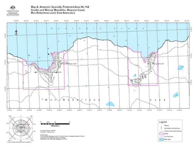
Part 65 Antarctic specially protected area No. 165
1 Name and Location
Edmonson Point, Wood Bay, Ross Sea.
Latitude 74° 20 S, longitude 165° 08 E.
2 Description
Edmonson Point, Wood Bay, Victoria Land, Ross Sea, was proposed as an Antarctic specially protected area by Italy on the grounds that it has outstanding ecological and scientific values which require protection from possible interference that might arise from unregulated access. The Area includes ice‑free ground and a small area of adjacent sea at the foot of the eastern slopes of Mount Melbourne (2 732 m), which is of limited extent and is the subject of ongoing and long‑term scientific research.
The terrestrial and freshwater ecosystem at Edmonson Point is one of the most outstanding in northern Victoria Land. An exceptional diversity of freshwater habitats is present, with numerous streams, lakes, ponds and seepage areas exhibiting nutrient conditions ranging from eutrophic to oligotrophic. Such a range of freshwater habitats is rare in Victoria Land. Consequently, these habitats support a high diversity of algal and cyanobacterial species, with over 120 species so far recorded, and the stream network is the most extensive and substantial in northern Victoria Land. The volcanic lithology and substrata, locally nutrient‑enriched by birds, together with a localised abundance of water, provide a habitat for relatively extensive bryophyte development. Plant communities are highly sensitive to changes in the hydrological regime, and environmental gradients produce sharply defined community boundaries. Thus, the range of vegetation is diverse, and includes epilithic lichen communities, some of which are dependent on high nitrogen input from birds, communities associated with late‑lying snow patches, and moss‑dominated communities that favour continually moist or wet habitats. The site represents one of the best examples of the latter community type in Victoria Land. Invertebrates are unusually abundant and extensively distributed for this part of Antarctica.
The nature and diversity of the terrestrial and freshwater habitats offer outstanding scientific opportunities, especially for studies of biological variation and processes along moisture and nutrient gradients. The site is considered one of the best in Antarctica for studies of algal ecology. These features were among those that led to the selection of Edmonson Point as a key site in the Scientific Committee on Antarctic Research’s Biological Investigations of Terrestrial Antarctic Systems (BIOTAS) programme in 1995–96. A coordinated multinational research programme, known as BIOTEX‑1, established study sites and made extensive collections of soil, rock, water, snow, guano, bacteria, vegetation (cyanobacterial mats, fungi, algae, lichens, bryophytes) and terrestrial invertebrates.
The scientific value of Edmonson Point is also considered exceptional for studies on the impact of climate change on terrestrial ecosystems. Its location at approximately the mid‑point in a north‑south latitudinal gradient extending along Victoria Land is complementary to other sites protected for their important terrestrial ecological values, such as Cape Hallett (ASPA No. 106) and Botany Bay, Cape Geology (ASPA No. 154), which are about 300 km to the north and south respectively. This geographical position is recognised as important in a continent‑wide ecological research network (eg the Scientific Committee on Antarctic Research ‘RiSCC’ programme). In addition, the lakes are among the best in northern Victoria Land for studies of biogeochemical processes with short‑ and long‑term variations. Together with the unique properties of the permafrost active layer, which is unusually thick in this location, these features are considered particularly useful as sensitive indicators of ecological change in response to levels of UV radiation and in shifting climate.
A colony of approximately 2 000 pairs of Adélie penguins (Pygoscelis adeliae) has been a focus of ongoing research since 1994–95, together with a colony of approximately 120 pairs of South Polar skuas (Catharacta maccormicki). The Edmonson Point Adélie penguin colony is included in the ecosystem monitoring network of the Commission for the Conservation of Antarctic Marine Living Resources (CCAMLR). The site is considered a good example of this species assemblage, which is representative of those found elsewhere. It is unusual, however, for the diverse range of breeding habitat available for South Polar skuas, and also because of the unusually high skua to penguin ratio (1:20). The geographical position, the size of the colonies, the terrain and habitat features of the site, the natural protection given by the summer fast ice extension and the distance from Mario Zucchelli Station at Terra Nova Bay (which isolates the colony from research station disturbance but allows for logistic support) make Edmonson Point particularly suitable for the research being undertaken on these birds. The research contributes to the CCAMLR Ecosystem Monitoring Programme (CEMP), focusing on population monitoring, reproductive success, feeding and foraging strategies, migration, and behaviour. This research is important to broader studies of how natural and human‑induced variations in the Antarctic ecosystem may affect the breeding success of Adélie penguins, and to understand the potential impact of harvesting of Antarctic krill (Euphausia superba).
The near‑shore marine environment is a good and representative example of the sea‑ice habitat used by breeding Weddell seals to give birth and wean pups early in the summer season. Only one other ASPA in the Ross Sea region has been designated to protect Weddell seals (Leptonychotes weddelli) (ASPA No. 137, north‑west White Island, McMurdo Sound), but that site was designated because the small breeding group of seals in that locality is highly unusual; in contrast, inclusion here is as a representative example similar to breeding sites throughout the region.
In addition to the outstanding biological values, a diversity of geomorphic features is present, including a series of ice‑cored moraines incorporating marine deposits, raised beaches, patterned ground, a cuspate foreland, and fossil penguin colonies. The cuspate foreland at Edmonson Point is a rare feature in Victoria Land, and is one of the best examples of its kind. It is unusual in that it is not occupied by a breeding colony of penguins, as is the case at Cape Hallett and Cape Adare. The glacial moraines that incorporate marine deposits, including seal bones and shells of the bivalves Laternula elliptica and Adamussium colbecki, are particularly valuable for dating regional glacier fluctuations. Sedimentary sequences in the north‑west of Edmonson Point contain fossils from former penguin colonies. These are useful for dating the persistence of bird breeding at the site, which contributes to reconstructions of Holocene glacial phases and palaeo‑climate.
The wide representation and the quality of phenomena at Edmonson Point have attracted interest from a variety of disciplines, and research has been carried out at the site for more than 20 years. Over this period, substantial scientific databases have been established, which adds to the value of Edmonson Point for current, ongoing and future research. It is important that pressures from human activities in the Area are managed so that the investments made in these long‑term data sets are not inadvertently compromised. These factors also make the site of exceptional scientific value for multi‑disciplinary studies.
Given the duration and range of past activities, Edmonson Point cannot be considered pristine. Some environmental impacts have been observed, such as occasional damage to soils and moss communities by trampling, dispersal of materials from scientific equipment by wind, and alteration of habitat by construction of facilities. In contrast, the ice‑free area at Colline Ippolito (Ippolito Hills) (1.67 km²) approximately 1.5 km to the north‑west, has received relatively little visitation and human disturbance at this site is believed to be minimal. As such, Colline Ippolito is considered particularly valuable as a potential reference area for comparative studies to the main Edmonson Point, and it is important that this potential scientific value is maintained. While the precise effects of scientific research and human presence at both sites are uncertain, because detailed studies on human impact have not yet been undertaken, contaminants in the local marine ecosystem remain very low and human impacts on the ecosystem as a whole, particularly at Colline Ippolito, are considered to be generally minor.
The biological and scientific values at Edmonson Point and Colline Ippolito are vulnerable to human disturbance. The vegetation, water‑saturated soils and freshwater environments are susceptible to damage from trampling, sampling and pollution. Scientific studies could be compromised by disturbance to phenomena or to installed equipment. It is important that human activities are managed so that the risks of impacts on the outstanding values of the Area are minimised.
The total Area of 5.49 km² comprises the ice‑free area of Edmonson Point (1.79 km²), the smaller but similar ice‑free area at Colline Ippolito (1.12 km²) approximately 1.5 km to its north which is designated a Restricted Zone, and the adjacent marine environment (2.58 km²) extending 200 m offshore from Edmonson Point and Colline Ippolito and including Baia Siena (Siena Bay).
3 Map
Part 66 Antarctic specially protected area No. 166
1 Name and Location
Port‑Martin, Terre Adélie.
Latitude 66° 49 S, longitude 141° 23 E.
2 Description
Originally, the historical site of Port‑Martin was designated as Historical Monument No. 46, proposed by France, in Recommendation XIII‑16 (Brussels, 1985).
The building of a base in Terre Adélie was programmed as Expedition TA21’s main task. This expedition left Brest (France) in November 1948 and reached the pack ice on 11 February 1949. Due to unfavourable ice conditions, it was unable to come ashore.
A new expedition, named TA3, succeeded on 18 January 1950 and on 20 January the final site was selected for the construction of the new base. The site took the name of Port‑Martin as a tribute to J A. Martin, a member of the expedition who died on board. A team of 11 men, under the leadership of André‑Franck Liotard, raised the main building — a pre‑cut wood frame, with oblique relieving posts — and then built several annexes to house mainly scientific activities (magnetism, geodesy, ionospheric sounding, atmospheric optics, biology, etc) as well as meteorology. Radio transmission antennae and wind machine towers were raised in the open spaces in between these buildings, along with an emergency shelter.
On 6 January 1951, the 17 members of the TA4 relief crew, under the leadership of Michel Barré, came ashore. They enlarged the main building while continuing and developing scientific activities.
Relief team TA5, under the command of René Garcia, reached Port‑Martin on 14 January 1952, while a reduced crew, led by Mario Marret (four men in total), were building a secondary base on Petrel Island (Pointe Geologie Archipelago).
During the night of 23–24 January 1952, the main building at the Port‑Martin base was destroyed by fire. The supply boat, which was still nearby, was able to evacuate the men, three of whom joined the original four who were dropped off at Pointe Geologie where they joined Mario Marret’s team. During that wintering season, the seven men of this rebuilt team carried out a raid on Port‑Martin to recover various supplies — including the two Weasels (caterpillar tractors) — which had been left there.
Since then, only limited visits of at most a few hours were made to this base, which is presumed to have been left as it was.
Today, what remains in Port‑Martin are the ancillary buildings, including the shelter, a weather shelter and the coal and supply sheds. With snow covering the remains of the main station year‑round, it is difficult to say precisely what was left after the fire. An archaeological mission needs to be sent there to inventory what remains of the buildings and the furniture they contained. But the ancillary buildings, witnesses to the organisation of a spatial base in Antarctica in the beginning of the 1950s, by themselves justify special protection.
In fact, Port‑Martin is the perfect illustration of a base in Antarctica in the immediate post‑war period, and its creation corresponds to the project of an International Geophysics Year. Yet, while it kept dog‑sled transport from the ‘Heroic Era’, it borrowed Weasels from the Mechanisation Era. Its goals, however, were resolutely part of the Scientific Era since, in spite of its brief actual operation, some progress in the study of earth sciences, weather and ionosphere are associated with it. As such, the site has a historical and cultural importance.
The short duration of its operation left a ‘snapshot’ of this history. No change — except for some superficial pillage — has altered its original implantations.
Furthermore, for future archaeology, the site represents an optimal site to design methods and techniques adapted to extreme archaeological investigation conditions. The site is partially covered in a snow that needs to be considered, conceptually, as a specific type of sediment. From the Port‑Martin deposit, archaeologists should be able to promote new concepts as well as a methodology adapted to it. These could be used for future archaeological study of other sites in Antarctica.
Therefore, Port‑Martin must be considered not only as a historical bridge site, but also as an original archaeological field, the exploitation and evaluation of which will require the design of specific, exemplary techniques, a new, privileged area for international cooperation in the spirit of the Treaty.
3 Map
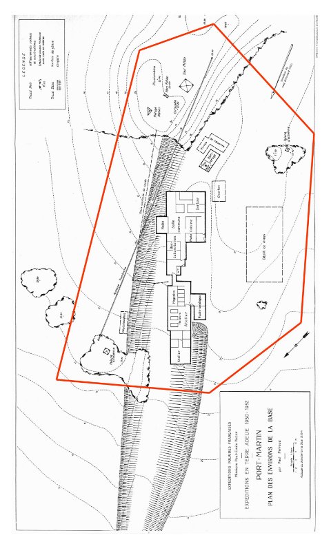
Part 67 Antarctic specially protected area No. 167
1 Name and location
Hawker Island, Vestfold Hills, Ingrid Christensen Coast, Princess Elizabeth Land, East Antarctica.
Latitude 68° 35 S, longitude 77° 50 E.
2 Description
Hawker Island, lying some 300 m off the Antarctic mainland, is located 7 km south‑west from the Australian Davis station in the Vestfold Hills on the Ingrid Christensen Coast, Princess Elizabeth Land, East Antarctica at 68° 35 S, 77° 50 E (Map A). The island supports a breeding colony of southern giant petrels (Macronectes giganteus) which is the southernmost colony of the species on continental Antarctica. The island also supports a colony of Adélie penguins (Pygoscelis adeliae) and a limited number of flying birds (Map B).
The southern giant petrel colony was discovered in December 1963, and at that time there were 40‑50 nests present, ‘some with eggs’. Seventeen population counts were undertaken between 1963 and 1999. A maximum of 90 nests with eggs was recorded in 1970–71. The recorded number of nests with eggs had decreased to 10 in 1983, but the 2 most recent surveys, conducted in 1987 and 1999, recorded 21 and 25 respectively.
Hawker Island is one of only four known breeding locations for southern giant petrels on the coast of continental Antarctica. The other locations have all been designated as Antarctic specially protected areas: ASPA No. 102, Rookery Islands, Holme Bay, MacRobertson Land (67º 36 S, 62º 53 E) — near Mawson Station; ASPA No. 160, Frazier Islands, Wilkes Land (66° 13 S, 110° 11 E) — near Casey station; and ASPA No. 120, Pointe‑Geologie, Terre Adélie (66º 40 S, 140º 01 E) — near Dumont d’Urville. Southern giant petrels on the Antarctic continent comprise less than 1% of the global breeding population. The current population for continental Antarctica is estimated at approximately 290 pairs, comprised of 25 pairs on Hawker Island, 3 pairs on Giganteus Island (part of the Rookery Islands group), 248 pairs on the Frazier Islands and 16 pairs at Pointe‑Geologie.
Southern giant petrels also breed on islands in the southern Indian and Atlantic Oceans and in the Antarctic Peninsula.
As indicated above, the breeding population of southern giant petrels at Hawker Island decreased following its discovery in the early 1960s by personnel from nearby Davis Station. Human disturbance has been implicated in the observed decreases at all four southern giant petrel breeding sites on continental Antarctica. The disturbance to colonies near the Australian stations arose primarily through early efforts (1950s–1970s) to band adults and chicks at the nest. The population decrease at Pointe‑Geologie has been attributed to station construction at Dumont d’Urville Station.
Southern giant petrels breeding in East Antarctica are particularly sensitive to disturbance at the nest. Restrictions in activities permitted at breeding sites, including a prohibition of banding, were introduced in the mid 1980s. While the population at Hawker Island has not recovered to the same extent as that on the Frazier Islands, it is showing signs of long‑term recovery.
Reductions in breeding populations of southern giant petrels at other locations in the Antarctic and subantarctic have been attributed to activities associated with research stations. The bycatch of southern giant petrels in longline fisheries operating in the Southern Ocean is also likely to have contributed to observed population decreases. Decreases in breeding populations of southern giant petrels have also been observed at sites where human disturbance has been minimal, such as Heard Island.
The global breeding population of southern giant petrels is estimated at around 31 300 pairs, and is inferred to be declining at a rate of 20‑50% over the past three generations. A total of 30 populations contain 500 or fewer breeding pairs, and at 15 of these sites there are 50 or fewer breeding pairs. It is believed that the global decrease in population is primarily due to fatal interactions with longline fisheries, although the species is also sensitive to other forms of human‑induced disturbance such as scientific research and visitor activities, ship movements and overflights. The species is listed as Vulnerable under IUCN criteria and has conservation status under a number of international agreements.
The overall decrease in the Hawker Island population of southern giant petrels since its discovery is consistent with global trends and suggests that continued and formalised protection of the colony is warranted. Long‑term protection and monitoring of the colony at Hawker Island will contribute to the development of appropriate regional and global conservation strategies for the species and will provide information for comparisons with populations elsewhere.
The designation of Hawker Island as an Antarctic specially protected area completes a suite of protected areas that safeguard all known southern giant petrel breeding locations in East Antarctica.
3 Maps
Map A
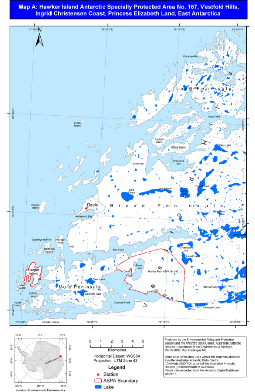
Map B
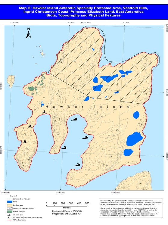
Schedule 2 Antarctic specially managed areas
(section 5)
Part 1 Antarctic specially managed area No. 1
1 Name and Location
Admiralty Bay, King George Island.
Latitude 62º 01 21 S—62º 14 09 S, longitude 58º 15 05 W—58º 41 02 W.
2 Description
Admiralty Bay has basic physiographic and aesthetic values as one of the most typical examples of bay/fjord settings in the South Shetland Islands. The ice‑free areas within Admiralty Bay are formed by recent and raised pebble‑cobble beaches, recent and sub‑recent moraines, mountainous peninsulas, rocky islets, spurs and nunataks. The terrain is heavily shaped by glacial, nival and coastal marine processes. These, together with the geological features of the area, add to the great scenic beauty of the landscape.
The area of Admiralty Bay is representative of the terrestrial, limnic, coastal, near‑shore, pelagic, and fjord‑bottom ecosystem of King George Island.
Flora is mostly represented by mosses, lichen and fungi formations. Twenty‑four species of birds and 6 species of pinnipeds have been registered for the Area, but only 13 species of birds and 3 species of pinnipeds actually breed within the Area.
The marine ecosystem of the bay largely reflects the general environmental conditions prevailing in the South Shetland Islands. However, there is a unique site, Napier Rock, at the entrance of the bay, where a rich and highly diverse benthic invertebrate fauna is found. Fish are represented by 15 species of Nototheniidae.
Diverse and continuous scientific activities have been undertaken in the Area for almost 30 years supported by the Polish Henryk Arctowski Station, by the Brazilian Comandante Ferraz Station and by the US Antarctic Program at ASPA No. 128 Western Shore of Admiralty Bay. Research activities at the Peruvian Machu Picchu Station (at Crepin Point) and at the Ecuadorian refuge (at Hennequin Point) have occurred intermittently during the summer.
Many features of Admiralty Bay are of considerable scientific interest. The main themes of field and laboratory research at the Polish and Brazilian stations have been marine and terrestrial biology, including physiology and adaptation of Antarctic fish and krill; taxonomy and ecology of the benthic fauna; vascular plants; mosses and lichens; terrestrial and marine ecology; migration and dispersion of birds. A long‑term research project on the biology and dynamics of bird populations (mainly Pygoscelid penguins) has been carried out by the US Antarctic Program since 1976. This study is of relevance for the CCAMLR Ecosystem Monitoring Programme (CEMP). Other studies include geology and palaeontology, glaciology and palaeoclimatology of the King George Island ice cap, and glacio‑marine sedimentation in Admiralty Bay. A year‑round seismic and Earth‑magnetism observatory, established at Arctowski Station in 1978, is the only station of its kind in the South Shetland Islands. Studies on atmospheric chemistry, geomagnetism, the ionosphere and astrophysics have been conducted at Ferraz Station since 1984. A meteorological station has been operational at Arctowski since 1977 and at Ferraz Station since 1984 to provide basic data and to support logistic operations. Research on upper atmosphere winds is being developed at Machu Picchu Station using MST radar.
Both Arctowski and Ferraz stations have hosted many foreign scientists (Argentineans, Belgians, Chileans, Germans, former Soviets and Russians, Netherlands, New Zealanders, Americans, Uruguayans and others). There is a strong tradition of cooperation between Polish and Brazilian scientists in matters related to Admiralty Bay and the South Shetland Islands as a whole.
A comprehensive study of the state of the environment in the Area is under way at Ferraz Station, comprising the analysis of a series of biotic and abiotic parameters. Results will serve as a baseline for future monitoring of activities and for implementation of a strategy for environmental management of the ASMA.
Sheltered deep harbours and accessible beaches ensured an early start to activities in Admiralty Bay. The bay offered protection for ships in the area during the sealing and whaling periods in the 19th and early 20th centuries, and ruins of installations related to the latter period still exist. Whale bones cover the beaches and are part of the landscape, remaining as heritage of this period.
The Area was visited by the second French Antarctic Expedition, Pourquoi Pas?, under Dr J B Charcot (1908–10), and by D Ferguson (1913–14), a geologist who took part in a British whaling expedition. Reports on minerals and rocks collected during these expeditions, published between 1910 and 1921, are among the first earth‑science publications on Admiralty Bay and the South Shetland Islands as a whole. The famous British Discovery voyages of 1934 and 1937 collected more rocks, as well as plants and animals from the Area. Results published from 1948 to 1964 constituted a substantial contribution to knowledge of the geology of Admiralty Bay. Argentina established a refuge hut at Keller Peninsula in 1948 (since dismantled) and the work of Argentinean geologists in Admiralty Bay in 1953 concentrated on fossil plants of the Tertiary age.
During the International Geophysical Year (1957–58), the UK Base ‘G’, on Keller Peninsula, Admiralty Bay (opened in 1947 and closed in 1961), later dismantled, was the centre of meteorological observations and glaciological and geological research.
Establishment of the Polish Arctowski Station in 1977 at Thomas Point, of the Brazilian Ferraz Station at Keller Peninsula in 1984, and of the Peruvian Machu Picchu Station at Crepin Point in 1989 has provided a sound basis for permanent research in Biological, Earth and Atmospheric sciences, which continues up to now. Ornithological research by US biologists began in 1976, with the establishment of Copacabana Station (unofficially called Pietr J. Lenie) covering the entire western side of Admiralty Bay, from Italian Valley (in Ezcurra Inlet) to Patelnia Point. Since 1985, ornithological research has also been occasionally undertaken at Keller Peninsula by Brazilian biologists.
Sites of ecological interest and scientific installations in the Area are frequently visited by tourists and participants in non‑governmental expeditions. These tourists and participants now have an opportunity to become familiar with the Antarctic environment and activities conducted there.
3 Map
Figure 2: Admiralty Bay Antarctic specially managed area — ASMA No. 1
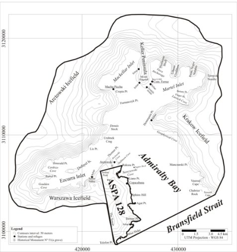
Part 2 Antarctic specially managed area No. 2
1 Name and location
McMurdo Dry Valleys, southern Victoria Land.
The Area boundaries have been defined primarily on the basis of the hydrological catchments in the McMurdo Dry Valleys, including all of the ice‑free ground and adjacent areas within these catchments, all of the Convoy Range, and the catchment of the Alph River. Starting at the northwest corner and moving counter‑clockwise, the boundary is delineated by the following features: the northwest tip of Allan Nunatak (76.7167 S, 159.6667 E), Carapace Nunatak (76.8833 S, 159.4 E), Mount DeWitt (77.2 S, 159.8333 E), the western edge of Horseshoe Mountain (77.5667 S, 159.95 E), Depot Nunatak (77.75 S, 160.0667 E), the southernmost peak of the Lashly Mountains (77.9606 S, 159.5603 E), Mount Kempe (78.3167 S, 162.7167 E), the Pyramid (78.35 S, 163.5 E), the east side of Heald Island (78.25 S, 163.8167 E), De Master Point (off the eastern end of Marshall Valley, 78.0792 S 164.4131 E), north along the coast following the mean low tide level to the east side of Tripp Island (76.6333 S, 162.7 E), the southern edge of Fry Glacier (76.6333 S, 162.3 E), and, again the northwest tip of the Allan Nunatak (76.7167 S, 159.6667 E).
2 Description
The McMurdo Dry Valleys are characterised as the largest relatively ice‑free region in Antarctica with approximately 30% of the ground surface largely free of snow and ice. The region encompasses a cold desert ecosystem, whose climate is not only cold and extremely arid (in the Wright Valley the mean annual temperature is ‑19.8°C and annual precipitation is less than 100 mm water equivalent), but also windy. The landscape of the Area contains glaciers, mountain ranges, ice‑covered lakes, meltwater streams, arid patterned soils and permafrost, sand dunes, and interconnected watershed systems. These watersheds have a regional influence on the McMurdo Sound marine ecosystem. The Area’s location, where large‑scale seasonal shifts in the water phase occur, is of great importance to the study of climate change. Through shifts in the ice–water balance over time, resulting in contraction and expansion of hydrological features and the accumulations of trace gases in ancient snow, the McMurdo Dry Valley terrain also contains records of past climate change. The extreme climate of the region serves as an important analogue for the conditions of ancient Earth and contemporary Mars, where such climate may have dominated the evolution of landscape and biota.
The Area is characterised by unique ecosystems of low biodiversity and reduced food web complexity. However, as the largest ice‑free region in Antarctica, the McMurdo Dry Valleys also contain relatively diverse habitats compared with other ice‑free areas. The Area contains unusual microhabitats and biological communities (such as endolithic and Cryoconite systems) as well as special geological features and minerals (for example, salt deposits and desert pavements). Some of these special geological features are of value because they contain an extremely long record of natural events. The long‑term data sets for environmental observations that have been collected in this region are some of the longest in Antarctica. The McMurdo Dry Valleys contain indicators of past and present regional climate change, as well as features that play a role in influencing local climate change.
These scientific values are of global as well as regional importance. The Area is a valuable resource for understanding landscape processes and the stability of Antarctic ice sheets. The McMurdo Dry Valleys contain unique surface deposits including glacially deposited and modified sediments, sand dunes, desert pavement, glacio‑lacustrine sediments, and marine fjord sediments containing valuable records of planetary change. The soil, rock, water, and ice environments and their associated biota are of scientific value as model ecosystems that allow deep insights into natural processes operating throughout the biosphere. Finally, the species that reside in the McMurdo Dry Valleys provide a biological resource for understanding adaptation to extreme environments, and are true end members of ecological continua.
The McMurdo Dry Valleys are also valued for their wilderness quality. They represent a nearly pristine environment largely undisturbed and uncontaminated by humans. The dramatic landscape, composed of high ridges and sweeping valleys, and contrasts of ice‑free and glacier‑covered terrain creates unique vistas with high aesthetic value.
Activities conducted in the area include a variety of scientific research; operations in support of science, media, arts, education and other official national programme visitors; and tourism. A long‑term Ecological Research site has been established in the Taylor Valley.
3 Map

Part 3 Antarctic specially managed area No. 3
1 Name and location
Cape Denison, Commonwealth Bay, George V Land.
Latitude 67 00 13 S—67 00 50 S, longitude 142 40 00.1 E—142 41 27 E.
2 Description
This ASMA is declared on the grounds that Cape Denison is a site of historic, aesthetic, educational, environmental and scientific values.
Historic value
Antarctica’s ‘Heroic Era’ was a period of great human adventure and discovery. Cape Denison, Commonwealth Bay, provides the setting for the buildings, structures and relics of the Main Base of the Australasian Antarctic Expedition (AAE) of 1911–14, led by Dr Douglas Mawson.
The prime focus of Mawson’s was scientific research. Nevertheless, the expedition also had an exploratory agenda, with the aim of charting the entire Antarctic coastline immediately south of Australia. For this purpose at least 5 sledging expeditions were undertaken from Cape Denison from spring 1912, including the infamous Far‑Eastern Sledging Party during which expeditioners Belgrave Ninnis and Xavier Mertz perished and Mawson himself barely survived. Overall, more than 6 500 km of coastline and hinterland was explored by sledging parties of the Expedition.
Cape Denison contains numerous relics relating to the work of Mawson’s expedition, including Mawson’s Huts and other significant and relatively untouched artefacts from the ‘Heroic Era’. While the majority is concentrated in the westernmost valley and its immediate surrounds, the historical boundaries of the Main Base extend further. Artefacts and other evidence of occupation, such as food caches, extend across the entire Cape, forming a rich resource of material available for research and interpretation, and potentially yielding scientific data and information about aspects of expeditioner life not included in official written accounts.
Aesthetic value
This ASMA is designated to preserve not only the artefacts remaining in situ but also the cultural landscape of Cape Denison in which Mawson and his men lived and worked. Cape Denison is characterised by its almost incessant blizzard conditions, which severely limit access to the region and activities at the site. System and katabatic winds pour down the plateau and funnel through the Cape’s valleys, blasting the hut with gusts that in May 1912 reached 322 km/h. (The average wind speed for the month was 98 km/h.) Cape Denison is not only the windiest place in Antarctica, but also the windiest place on Earth at sea level. The site thus provides the physical and symbolic context of the extreme isolation and harsh conditions endured by the expedition members and, by association, all other ‘Heroic Era’ researchers and explorers. In designating the entire area as an ASMA, Cape Denison’s unique ‘sense of place’ is protected, with Mawson’s Huts and Boat Harbour as the focus of the visual catchment. Mawson’s Huts themselves are provided with additional protection in ASPA 162.
Educational value
Cape Denison’s wildlife and undisturbed artefacts, framed against the dramatic backdrop of the Antarctic Plateau, represent significant educational values. The Area’s isolation and extreme weather provide visitors with a unique insight into the conditions endured by ‘Heroic Era’ researchers and explorers, and a chance to form a deeper appreciation of their achievements.
Environmental value
The paucity of relatively ice‑free areas in the immediate region means that Cape Denison represents an important assemblage of life forms. The closest ice‑free areas of equal or greater size to Cape Denison are approximately 20 km to the east of Cape Denison (from the centroid of the ASMA), and approximately 60 km to the west respectively. A haul‑out site for Weddell seals (Leptonychotes weddelli), leopard seals (Hydrurga leptonyx) and elephant seals (Mirounga leonina), the Cape is also an important breeding area for Adélie penguins (Pygoscelis adeliae), Wilson's storm petrels (Oceanites oceanicus), Snow petrels (Pagodroma nivea) and South Polar skuas (Catharacta maccormicki).
Flora at Cape Denison is represented by 13 lichen species distributed on boulders and other moraines throughout the peninsula. No bryophytes are evident. The lichens’ distribution on rocks, which are subject to different patterns of snow ablation, makes them vulnerable to trampling and other interference by visitors, however infrequent visitation may be.
Cape Denison has 13 small lakes. These are associated with glacial action, are a permanent feature, and are frozen over for most of the year. Since such lakes are also susceptible to physical, chemical and biological modification within their catchment boundaries, a catchment‑based approach to the management of human activities is required.
Scientific value
Mawson, a geologist, planned his expedition in order to examine the theories about continental connection and the processes of glaciation and climate. He also sought to study the South Magnetic Pole and magnetic charting for navigational purposes; to conduct biological studies, including the identification of new species; and to establish a weather station.
Cape Denison provides opportunities to repeat Mawson’s experiments and conduct further research into magnetism, meteorology, biology, and other sciences. For example, although Antarctic lakes are generally recognised as valuable due to their relatively simple natural ecosystems, the lakes at Cape Denison have neither been sampled nor their biota studied. There are also numerous non‑marine algae present; however, no surveys have been undertaken.
The records from Mawson’s expedition provide a dataset against which the results of modern research may be compared, and the site’s isolation lends it considerable value for future use as a reference site for other areas that experience a greater level of human activities.
3 Map
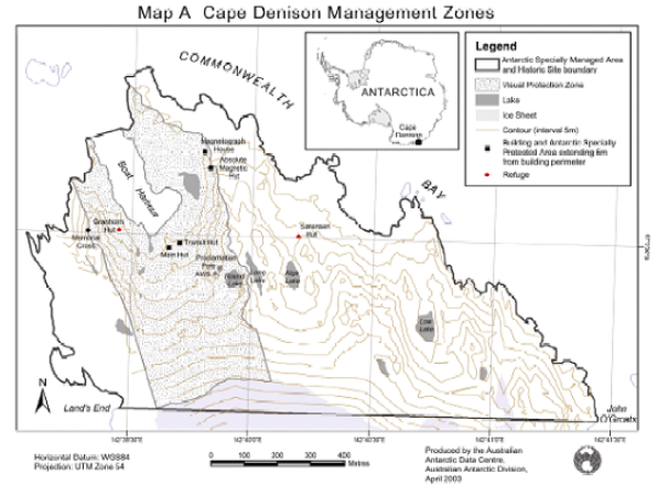
Part 4 Antarctic specially managed area No. 4
1 Name and location
Deception Island, South Shetland Islands.
Latitude 62 57 S, longitude 60 38 W.
2 Description
Natural value
Deception Island is one of only two volcanoes in the Antarctic at which eruptions have been observed. It was responsible for numerous ash layers dispersed across the South Shetland Islands, Bransfield Strait and the Scotia Sea. Ash from the island has even been recorded in an ice core at the South Pole. The volcano erupted during two short periods during the 20th century, most recently between 1967 and 1970. It contains a restless caldera that is actively deforming. It is therefore likely that Deception Island will witness further eruptions in the future.
The Area has an exceptionally important flora, including at least 18 species which have not been recorded elsewhere in the Antarctic. No other Antarctic area is comparable. Of particular importance are the very small, unique biological communities associated with the island’s geothermal areas, and the most extensive known community of the flowering plant Antarctic pearlwort (Colobanthus quitensis).
Eight species of seabird breed on the island, including the worlds largest colony of chinstrap penguins (Pygoscelis antarctica).
The benthic habitat of Port Foster is of ecological interest due to the natural perturbations caused by volcanic activity.
Scientific value and activities
The Area is of outstanding scientific interest, in particular for studies in geoscience and biological science. It offers the rare opportunity to study the effects of environmental change on an ecosystem, and the dynamics of the ecosystem as it recovers from natural disturbance.
Long‑term seismological and biological data‑sets have been collected at Decepciόn Station (Argentina) and Gabriel de Castilla Station (Spain).
Historic value
The Area has had a long history of human activity since c.1820, including exploration, sealing, whaling, aviation and scientific research, and as such has played a significant role in Antarctic affairs.
At Whalers Bay, the Norwegian Hektor whaling station, the cemetery and other artefacts, some of which pre‑date the whaling station, are the most significant whaling remains in the Antarctic. The British ‘Base B’, which was established in the abandoned whaling station, was the first base of the secret World War II expedition ‘Operation Tabarin’, the forerunner to the British Antarctic Survey. As such, it was one of the earliest permanent research stations in Antarctica. The whalers’ remains and Base B are listed as Historic Site and Monument (HSM) No. 71.
The remains of the Chilean Presidente Pedro Aguirre Cerda Station at Pendulum Cove are listed as HSM No. 76. Meteorological and volcanological studies were undertaken at the base from 1955 until its destruction by volcanic eruptions in 1967 and 1969.
Aesthetic value
Deception Island’s flooded caldera, its ‘horse‑shoe’ shape and linear glaciated eastern coastline, its barren volcanic slopes, steaming beaches and ash‑layered glaciers provide an unique Antarctic landscape.
Educational and tourism values
Deception Island is the only place in the world where vessels can sail directly into the centre of a restless volcanic caldera, providing the opportunity for visitors to learn about volcanoes and other aspects of the natural world, as well as early Antarctic exploration, whaling and science. Deception Island is also one of the most frequently visited sites in Antarctica by tourists.
3 Map