Commonwealth of Australia
Radiocommunications Act 1992
Radiocommunications Advisory Guidelines
(Co-ordinating the operation of transmitters
in the 500 MHz Bands)
I, CHRISTINE MARY GOODE, Spectrum Manager, acting on behalf of the Spectrum Management Agency, make the following instrument under subsection 262 (1) of the Radiocommunications Act 1992.
Dated 6th November 1996.
Christine M. Goode
Spectrum Manager
____________
PART 1GENERAL INFORMATION
Purpose of these guidelines
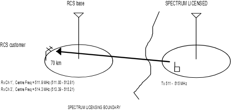
The purpose of these advisory guidelines is to provide guidance to spectrum licensees in the 500 MHz bands (between 501-505 MHz and 511-515 MHz) on the operation of transmitters located within range of Telstra radio concentrator systems (RCS). These systems are used to deliver a telecommunications service to rural areas of inland Australia and their presence must be taken into account by spectrum licensees before operating their transmitters.
RCS follow frequency and cell plans that utilise frequencies for base transmitters in both the lower band (501-505 MHz) and upper band (511-515 MHz). Interference within the RCS network is controlled by the use of a cellular frequency re-use plan. Each RCS site is allocated a channel which results in acceptable co-channel and adjacent channel interference from other RCS sites.
Spectrum licensed transmitters do not follow the same cell plans as RCS and need to be specially coordinated in order to manage the level of interference to the RCS network. These advisory guidelines provide coordination procedures that spectrum licensees should follow in order to ensure that the power radiated from their transmitters in the direction of affected RCS sites is kept to an acceptable level.
The SMA does not intend to afford protection to receivers operated under spectrum licences from any interference they may encounter from RCS transmitters operated in accordance with their apparatus licence. The SMA also intends to afford protection, in accordance with these Advisory Guidelines, to RCS receivers from transmitters operated under a spectrum licence. Each case will be assessed on its merits.
Possible interference scenarios
The cellular implementation of RCS is such that an RCS base transmit frequency in one cluster of cells is never used by an RCS customer transmit frequency in another cluster. However, they can operate on either the lower band or the upper band. Table 1 below shows the affected frequency assignments for RCS base station, RCS customer and RCS repeaters.
RCS Parameters | Tx freq (MHz) Note 1 | Rx freq (MHz) |
Base Station | 503.1 (2), 505.5 (4), 511.9 (1'), 514.3 (3') | 513.1 (2'), 515.5 (4'), 501.9 (1), 504.3 (3) |
Customer Station | 501.9 (1), 504.3 (3), 513.1 (2'), 515.5 (4') | 511.9 (1'), 514.3 (3'), 503.1 (2), 505.5 (4) |
Repeater Station | 501.9 (1), 503.1 (2), 504.3 (3), 505.5 (4), 511.9 (1'), 513.1 (2') 514.3 (3'), 515.5 (4') | 511.9 (1'), 513.1 (2'), 514.3 (3'), 515.5 (4'), 501.9 (1), 503.1 (2), 504.3 (3), 505.5 (4) |
Table 1 RCS frequency assignments
Note 1. Tx frequencies only shown for information purposes
Note 2. (2) Figures in brackets represent RCS channel numbers
As can be seen from Table 1 there are four affected RCS frequencies (channels) in each of the lower and upper bands. Under spectrum licensing, spectrum licensed transmitters may operate in the lower band or the upper band. This gives rise to two possible interference scenarios:
Scenario 1 Spectrum licensed transmitters operating in the lower band (501 - 505 MHz) with RCS base or repeater or customer receivers; and
Scenario 2 Spectrum licensed transmitters operating in the upper band (511 - 515 MHz) with RCS base or repeater or customer receivers.
Scenario 1 Co-ordination of spectrum licensed transmitters operating in the lower band (501-505 MHz) with RCS base or repeater or customer receivers.
RCS base station receivers with centre frequencies 501.9 MHz (ch 1) and 504.3 MHz (ch 3)
RCS repeater station receivers with centre frequencies 501.9 MHz (ch 1), 503.1 MHz (ch 2), 504.3 MHz (ch 3) and 505.5 MHz (ch 4)
RCS customer station receivers with centre frequencies 503.1 MHz (ch 2) and 505.5 MHz (ch 4)
Scenario 2 Co-ordination of spectrum licensed transmitters operating in the upper band (511 - 515 MHz) with RCS base or repeater or customer receivers
RCS base station receivers with centre frequencies 513.1 MHz (ch 2') and 515.3 MHz (ch 4')

RCS repeater station receivers with centre frequencies 511.9 MHz (ch 1'), 513.1 MHz (ch 2'), 514.3 MHz (ch 3') and 515.3 MHz (ch 4')
RCS customer station receivers with centre frequencies 511.9 MHz (ch 1') and 514.3 MHz (ch 3')
Assessing the potential for interference between a spectrum licensed transmitter and RCS base/repeater/customer receivers under Part 2 of these Advisory Guidelines
Spectrum licensees will, in some cases, be required to assess the level of potential interference from a proposed spectrum licensed transmitter to each affected RCS site. Spectrum licensees will be responsible for ensuring that the level of interference is lower than the maximum long term[1] allowable interference appropriate to RCS receivers. The coordination procedure is set out in Part 2 of these Advisory Guidelines.
In many cases the levels of interference between RCS and spectrum licensed transmitters will be well within acceptable limits, and there will be no need to carry out the detailed coordination procedures set out in Part 2 of these Advisory Guidelines. Spectrum licensees can use the look-up table in Table 2 in Part 2 to determine if there is a need to carry out detailed coordination.
Recommendation ITU-R PN.526-3 should be used for calculating terrain loss between two sites. The interference path loss is modelled by diffraction over spherical earth or diffraction over obstacles (eg knife edge or multiple knife edge obstructions). The method is given in Schedule 2.
PART 2COORDINATION PROCEDURES
Interpretation
1. In this Part:
‘effective occupied bandwidth’ has the meaning it has in the Radiocommunications Spectrum Marketing Plan (500 MHz Band) 1996;
‘EIRP’ means equivalent isotropically radiated power;
‘horizontally radiated power’ has the meaning it has in Radiocommunications Spectrum Marketing Plan (500 MHz Band) 1996;
‘lower band’ has the meaning it has in Radiocommunications Spectrum Marketing Plan (500 MHz Band) 1996;
‘minimum distance’ means the distance worked out in accordance with clause 2;
‘upper band’ has the meaning it has in Radiocommunications Spectrum Marketing Plan (500 MHz Band) 1996.
Meaning of “minimum distance”
2. The minimum distance is, for a transmitter that is located at a height nearest to the value set out in an item in the left hand column of Table 2 below, with an EIRP for each 12.5 kHz of bandwidth nearest to the value set out in a column of the top row of the table the distance in kilometres set out in that column of the item.
Ht (metres above sea level) |
49 | EIRP/12.5 kHz (dBm) 40 |
30 |
20 | 290 | 265 | 245 |
60 | 315 | 295 | 270 |
100 | 330 | 310 | 285 |
200 | 355 | 335 | 310 |
500 | 400 | 380 | 355 |
1000 | 460 | 435 | 415 |
1600 | 510 | 485 | 460 |
Table 2 Coordination Look-up Table
Coordination of RCS with spectrum licensed transmitters
3. (1) This clause applies to a person who is operating, or intends to operate, under a spectrum licence, a transmitter:
(a) that is located at a point that is at a distance that is equal to or less than the minimum distance from an RCS base receiver that is authorised to operate on the frequency:
(i) 501.9 Megahertz; or
(ii) 503.1 Megahertz; or
(iii) 504.3 Megahertz; or
(iv) 505.5 Megahertz; and
(b) that has its emission centre frequency plus or minus half the effective occupied bandwidth within plus or minus 910 kHz of any of the frequencies referred to in paragraph (a).
[NOTE: A list of RCS base/repeater/customer site coordinates operating in these bands is provided in Schedule 1. The site and frequency convention sense used in Schedule 1 is the same as that of the SMA's RADCOM database. A site name under the field A_SITE will correspond to a site with transmitting frequency A_FREQ and receiving frequency B_FREQ. eg. The receive frequency for site Cheviot Hills would be 511.9 MHz.
The field names A_STREET, B_STREET, A_ANT_TYPE and B_ANT_TYPE used in RADCOM should be used to determine whether A_SITE or B_SITE is an RCS base/repeater or an RCS customer station. eg. field antenna types of site A (A_ANT_TYPE) with U, T are associated with omni antenna, a base station site. Antenna type 4MP associated with ‘radio terminal’ is a 4 metre parabolic directional repeater antenna. Antenna type 15 1Y associated with ‘RCS subscribers’ is a 15 element directional customer Yagi antenna.
Only limited RADCOM fields are included in Schedule 1.]
(2) For the purposes of following the procedures set out in this clause, the person should:
(a) if a procedure involves calculations in relation to an RCS customer receiver, assume that the customer receiver:
(i) is located at the site of the RCS base station to which it relates; and
(ii) has an antenna with an antenna gain of 15 dBi and an antenna height of 10 metres;
(b) if a procedure involves calculations in relation to a transmitter that is operated in the upper band under a spectrum licence, assume that the transmitter is located at the site of the base station to which it relates. If there are emissions emanating from other sites that are likely to result in RCS levels of protection being exceeded then these should also be analysed.
(c) if a procedure involves calculations in relation to an RCS repeater station, take account of the directional characteristics of the antenna that is used in conjunction with the repeater station.
(3) The person should calculate the propagation loss in accordance with the following formula:
Lb = Lbf + Lt
where:
Lb = Propagation loss (dB)
Lbf = Free Space Loss (dB)
32.4 + 20 log(500 . d) where d = separation distance in kilometres
Lt = Terrain Loss modelled by spherical earth or knife edge or multiple knife edge diffractions (dB) as specified in ITU-R 526-3. [NOTE: See Schedule 2]
[NOTE: Apart from FSL, propagation loss associated with terrain will determine the required level of protection to RCS receivers. Long term terrain protection is associated with diffraction loss at an effective Earth's radius or k-factor and can be calculated as shown in Schedule 2. A k-factor of 3 which corresponds to a percentage of time greater than 20% (ITU-R Rec 758 and RALI FX3) is used in the analysis.]
(4) The person should calculate the level of unwanted power from the operation of the transmitter that is received by the RCS base receiver using the following formula:
Pu = EIRPt - Lb + Gr - Dr
where:
Pu = Unwanted Power (dBm/12.5 kHz)
EIRPt = proposed spectrum licensed horizontally radiated power for the transmitter (dBm/12.5 kHz EIRP) that is within the bandwidth of the RCS receiver and in the direction of the RCS receiver
Lb = Lbf + Lt
Gr = gain of RCS receiver antenna (dBi)
for RCS base refer to RADCOM database (typically 8/11 dBi)
for RCS repeater refer to RADCOM database (typically 17/20/23 dBi)
for customer Gr = 15 dBi
Dr = Antenna Discrimination in the direction of spectrum licence transmitter (dB)
for RCS base Dr = 0
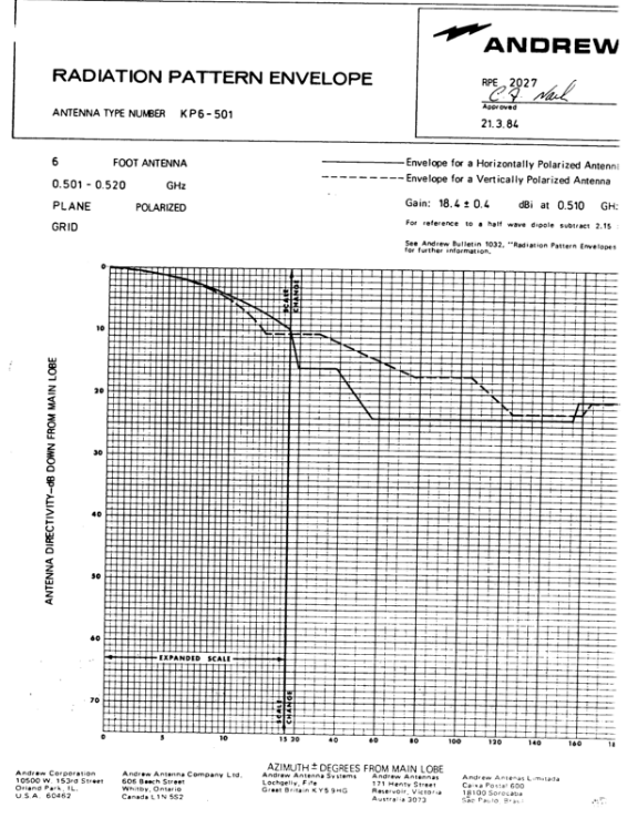
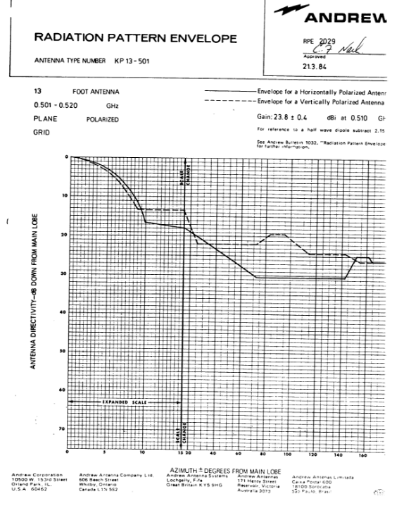
for RCS repeater refer Schedule 3
for customer Dr = 0 dB (assume that customer antenna is pointing at spectrum licence transmitter)
(5) The level of unwanted power obtained using the formula in subclause (4) should be no greater than - 134.1 dBm/12.5 kHz.
[NOTE: The maximum value for permissible level of interference into a RCS receiver (IRCS) is worked out using the following formula:
IRCS(dBm/12.5 kHz) = RCS thermal noise - Noise for 1 dB degradation - bandwidth adjustment
= -106.5 -6 - 10 log (1820/12.5)
= -134.1 dBm]
SCHEDULE 1
RCS SITE COORDINATES WITHIN 350 KM OF SPECTRUM LICENCE TRANSMITTER
NSW |
|
|
|
|
|
|
|
|
|
|
|
A_FREQ | B_FREQ | A_SITE | B_SITE | A_STREET | B_STREET | A ZONE | A_EAST | A_NORTH | B_ZONE | B_EAST | B_NORTH |
511.9 | 501.9 | ANDERSONS HILL | ANDERSONS HILL | RADIO TERMINAL | ANDERSONS HILL SUBS 60KM | 54 | 662622 | 6504276 | 54 | 662622 | 6504276 |
513.1 | 503.1 | BALRANALD | BALRANALD | DRCS SUBSCRIBERS | TELEPHONE EXCHANGE | 0 | - | - | 54 | 735030 | 6163751 |
514.3 | 504.3 | BARRAROO | BARRAROO | RADIO TERMINAL | BARRAROO SUBS 60KM RADIUS | 54 | 682394 | 6430196 | 54 | 682394 | 6430196 |
514.3 | 504.3 | BROKEN HILL | THACKARINGA | TELEPHONE EXCHANGE |
| 54 | 544470 | 6464905 | 54 | 516206 | 6454058 |
514.3 | 504.3 | BUCKAMBOOL | BUCKAMBOOL |
| DRCS SUBSCRIBERS(60KMS RA | 55 | 373574 | 6465760 | 55 | 373574 | 6465760 |
514.3 | 504.3 | BUCKAMBOOL | THE COTTAGE |
|
| 55 | 373574 | 6465760 | 55 | 322840 | 6463406 |
514.3 | 504.3 | BUCKAMBOOL | THULE HUT |
|
| 55 | 373574 | 6465760 | 55 | 381185 | 6414727 |
511.9 | 501.9 | COBAR | BUCKAMBOOL | TELEPHONE EXCHANGE |
| 55 | 389681 | 6514202 | 55 | 373574 | 6465760 |
513.1 | 503.1 | CORONGA PEAK | MT BOPPY |
| TELECOM SITE | 55 | 429517 | 6577541 | 55 | 431630 | 6509900 |
511.9 | 501.9 | DARNICK | DARNICK | DRCS REPEATER | DRCS SUBS (60K RADIUS OF) | 54 | 749446 | 6368523 | 0 | - | - |
514.3 | 504.3 | GIRILAMBONE | GIRILAMBONE | DRCS BASE (TDM) | DRCS SUBSCRIBERS | 55 | 490290 | 6541750 | 55 | 400000 | 6400000 |
511.9 | 501.9 | HILLSTON | HILLSTON | TELEPHONE EXCHANGE | HILLSTON SUBS 60KM RADIUS | 55 | 363523 | 6293704 | 0 | - | - |
511.9 | 501.9 | HILLSTON | WARANARY HILL | TELEPHONE EXCHANGE | RADIO TERMINAL | 55 | 363523 | 6293704 | 55 | 349950 | 6342170 |
511.9 | 501.9 | MAUDE | OXLEY | TELEPHONE EXCHANGE | RADIO TERMINAL | 55 | 252543 | 6182453 | 55 | 238225 | 6231701 |
511.9 | 501.9 | MENINDEE | MENINDEE | REPEATER | DRCS SUBS | 54 | 633240 | 6414793 | 0 | - | - |
511.9 | 501.9 | MENINDEE | WILLOTIA | REPEATER LINK | REPEATER LINK | 54 | 633240 | 6414793 | 54 | 623890 | 6366019 |
514.3 | 504.3 | MIN MIN | MIN MIN | DRCS BASE | DRCS SUBSCRIBERS | 54 | 770360 | 6282726 | 0 | - | - |
513.1 | 503.1 | MOSSGIEL | MOSSGIEL | DRCS SUBS (60KM RADIUS) | DRCS REPEATER | 0 | - | - | 55 | 273505 | 6317358 |
513.1 | 503.1 | MT BOPPY | MT BOPPY | DRCS SUBSCRIBERS(60KMS RA | TELECOM SITE | 55 | 431630 | 6509900 | 55 | 431630 | 6509900 |
513.1 | 503.1 | MT DERING | NUNDOOKA | RADIO TERMINAL | RADIO TERMINAL | 54 | 558025 | 6516228 | 54 | 565191 | 6587310 |
513.1 | 503.1 | NETLEY | THACKARINGA |
|
| 54 | 541118 | 6389817 | 54 | 516206 | 6454058 |
514.3 | 504.3 | NUNDOOKA | WONNAMINTA | RADIO TERMINAL | REPEATER | 54 | 565191 | 6587310 | 54 | 624210 | 6601004 |
513.1 | 503.1 | NYMAGEE | MT BOPPY |
| TELECOM SITE | 55 | 437128 | 6457327 | 55 | 431630 | 6509900 |
513.1 | 503.1 | PINE RIDGE | PINE RIDGE | PINE RIDGE SUBS-60KM RAD | RADIO TERMINAL | 0 | - | - | 55 | 428466 | 6375911 |
514.3 | 504.3 | QUAMBONE | BUCKINGUY | DRCS BASE | DRCS BASE | 55 | 582958 | 6577698 | 55 | 544333 | 6581500 |
514.3 | 504.3 | QUAMBONE | QUAMBONE | DRCS BASE | DRCS SUBS RADIUS | 55 | 582958 | 6577698 | 55 | 582958 | 6577698 |
514.3 | 504.3 | QUAMBONE | WARRINGTON | DRCS BASE | DRCS BASE | 55 | 582958 | 6577698 | 55 | 619710 | 6605399 |
513.1 | 503.1 | THACKARINGA | THACKARINGA | SUBSCRIBERS | REPEATER | 54 | 516206 | 6454058 | 54 | 516206 | 6454058 |
513.1 | 503.1 | TOTTENHAM | TOTTENHAM | DRCS CUSTOMERS | RATV SITE (HYBRID REPETR) | 0 | - | - | 55 | 531298 | 6435146 |
514.3 | 504.3 | WAKOOL | MOULAMEIN | REPEATER | REPEATER | 55 | 263045 | 6071841 | 55 | 229619 | 6112910 |
504.3 | 504.3 | WARANARY HILL | WARANARY HILL | RADIO TERMINAL | RADIO TERMINAL | 55 | 349950 | 6342170 | 55 | 349950 | 6342170 |
514.3 | 504.3 | WARREN | WARREN AREA | TELEPHONE EXCHANGE | DRCS SUBSCRIBER STATIONS | 55 | 579363 | 6492345 | 0 | - | - |
511.9 | 501.9 | WARRINGTON | WARRINGTON | DRCS BASE | DRCS SUBS RADIUS | 55 | 619710 | 6605399 | 55 | 619710 | 6605399 |
511.9 | 501.9 | WARRINGTON | WARRINGTON | DRCS BASE | DRCS BASE | 55 | 619710 | 6605399 | 55 | 619710 | 6605399 |
514.3 | 504.3 | WEEMELAH | WEEMELAH | DRCS BASE | DRCS SUBS RADIUS | 55 | 719610 | 6788589 | 55 | 719610 | 6788589 |
513.1 | 503.1 |
| BUCKINGUY | -- NO RELATED RECORD -- | RADIO TERMINAL |
|
|
| 55 | 544333 | 6581500 |
514.3 | 504.3 |
| WARANARY HILL | -- NO RELATED RECORD -- | WARANARY HILL SUBS 60KM |
|
|
| 55 | 349950 | 6342170 |
515.5 | 505.5 | ANDERSONS HILL | GLEN LYON | RADIO TERMINAL | RADIO TERMINAL | 54 | 662622 | 6504276 | 54 | 618090 | 6456679 |
515.5 | 505.5 | BARRAROO | GLEN LYON | RADIO TERMINAL | RADIO TERMINAL | 54 | 682394 | 6430196 | 54 | 618090 | 6456679 |
515.5 | 505.5 | COLANE AREA | COLANE | DRCS SUBSCRIBERS |
| 0 | - | - | 55 | 523222 | 6542408 |
515.5 | 505.5 | COLLARENEBRI | COLLARENEBRI | DRCS SUBS 60KM RADIUS | COLLARENEBRI RATV | 55 | 652899 | 6730974 | 55 | 652899 | 6730974 |
515.5 | 505.5 | GLEN LYON | GLEN LYON | GLEN LYON SUBS 60KM RAD | RADIO TERMINAL | 0 | - | - | 54 | 618090 | 6456679 |
515.5 | 505.5 | MACCULLOCHS RANGE | MACCULLOCHS RANGE | DRCS SUBS | REPEATER | 54 | 767113 | 6489874 | 54 | 767113 | 6489874 |
515.5 | 505.5 | MARRA | MACCULLOCHS RANGE | REPEATER | REPEATER | 54 | 786249 | 6559653 | 54 | 767113 | 6489874 |
515.5 | 505.5 | MENINDEE | GLEN LYON | REPEATER | REPEATER | 54 | 633240 | 6414793 | 54 | 618090 | 6456679 |
515.5 | 505.5 | RAVENSFIELD | RAVENSFIELD | RAVENSFIELD SUBS 60KM RAD | RADIO TERMINAL | 55 | 279663 | 6279160 | 55 | 279663 | 6279160 |
|
|
|
|
|
|
|
|
|
|
|
|
|
|
|
|
|
|
|
|
|
|
|
|
QLD |
|
|
|
|
|
|
|
|
|
|
|
A_FREQ | B_FREQ | A_SITE | B_SITE | A_STREET | B_STREET | A ZONE | A_EAST | A_NORTH | B_ZONE | B_EAST | B_NORTH |
513.1 | 503.1 | AVONMORE HSTD | AVONMORE HMSD | DRCS SUBS(34KM RADIUS OF) | RADIO TERMINAL (14KM SSW) | 55 | 475500 | 7349601 | 55 | 475500 | 7349600 |
513.1 | 503.1 | BRUCEDALE | ROMA | RADIO TERMINAL | RADIO TERMINAL | 55 | 690715 | 7022291 | 55 | 684152 | 7059394 |
511.9 | 501.9 | CONNORS RIVER | CONNORS RIVER | RADIO TERMINAL | RADIO TERMINAL | 55 | 704087 | 7558831 | 55 | 704087 | 7558831 |
511.9 | 501.9 | COOKTOWN | COOKTOWN | RADIO TERMINAL | DRCS SUBS (16KM RADIUS OF | 55 | 311399 | 8287620 | 55 | 311400 | 8287600 |
511.9 | 501.9 | COOKTOWN | MT MISERY | RADIO TERMINAL | RADIO TERMINAL | 55 | 311399 | 8287620 | 55 | 310093 | 8243486 |
511.9 | 501.9 | COOKTOWN | MT PIEBALD | RADIO TERMINAL | RADIO TERMINAL | 55 | 311399 | 8287620 | 55 | 294548 | 8305705 |
514.3 | 504.3 | DAWES RANGE | CANIA | RADIO TERMINAL | TELECOM SITE | 56 | 284845 | 7266746 | 56 | 295576 | 7271889 |
514.3 | 504.3 | DAWES RANGE | DAWES RANGE | MICROWAVE REPEATER | MICROWAVE REPEATER STN AR | 56 | 284847 | 7266760 | 56 | 284850 | 7266770 |
513.1 | 503.1 | DRCS SUBSCRIBERS | NEWLANDS | RADIO TERMINAL | RADIO TERMINAL | 55 | 591245 | 7654288 | 55 | 591245 | 7654288 |
513.1 | 503.1 | DUNRAVEN | DUNRAVEN | DRCS SUBSCRIBERS 20 KM | RADIO TERMINAL | 54 | 552179 | 7816691 | 54 | 808700 | 7729700 |
511.9 | 501.9 | GIDYEA CREEK | GIDYEA CREEK | RADIO TERMINAL | DRCS SUBSCRIBERS 30 KM | 55 | 471539 | 7625740 | 55 | 471539 | 7625740 |
511.9 | 501.9 | GLENDON HOMESTEAD | ROSCOE | ROSCOE R/T (2KM W OF) | DRCS SUBS(53KM RADIUS OF) | 54 | 767800 | 7387800 | 55 | 217222 | 8112222 |
513.1 | 503.1 | GRAFTON RANGE | ROMA | RADIO TERMINAL | RADIO TERMINAL | 55 | 699400 | 7088600 | 55 | 684152 | 7059394 |
513.1 | 503.1 | GULUGUBA | GULUGUBA | DRCS SUBS (28KM RADIUS OF | RADIO TERMINAL 15 KM E OF | 56 | 219722 | 7089322 | 56 | 219700 | 7089300 |
513.1 | 503.1 | LESTREE HILL | RECRUIT HOMESTEAD | RADIO TERMINAL | BANCHORY R/T (4KM S OF) | 55 | 468600 | 7475000 | 55 | 500500 | 7483200 |
514.3 | 504.3 | LYND RIVER | KELLYS CREEK | RADIO TERMINAL | RADIO TERMINAL | 55 | 275300 | 8005700 | 55 | 262663 | 7971754 |
514.3 | 504.3 | LYND RIVER | LYND RIVER | RADIO TERMINAL | DRCS SUBS 34KM RADIUS OF | 55 | 274300 | 8005700 | 55 | 274322 | 8005722 |
513.1 | 503.1 | LYND RIVER | MOUNT GARNET | RADIO TERMINAL | RADIO TERMINAL | 55 | 274300 | 8005700 | 55 | 300510 | 8043470 |
514.3 | 504.3 | LYND RIVER | MURRAY SPRING CREEK | RADIO TERMINAL | RADIO TERMINAL 2KM SE | 55 | 274300 | 8005700 | 55 | 340452 | 7993332 |
514.3 | 504.3 | MOUNT FOX | EWAN | OAK HILLS RD | RADIO TERMINAL | 55 | 375900 | 7919700 | 55 | 373400 | 7893800 |
514.3 | 504.3 | MOUNT FOX | HIDDEN VALLEY | OAK HILLS RD | RADIO TERMINAL | 55 | 375900 | 7919700 | 55 | 393350 | 7902100 |
514.3 | 504.3 | MOUNT FOX | MT FOX | OAK HILLS RD | DRCS SUBS 15KM RADIUS | 55 | 375900 | 7919700 | 55 | 368900 | 7929300 |
514.3 | 504.3 | MOUNT FOX | SANDY CREEK | OAK HILLS RD | RADIO TERMINAL | 55 | 375900 | 7919700 | 55 | 348700 | 7910750 |
514.3 | 504.3 | MOUNT FOX | SEAVIEW RANGE | OAK HILLS RD | RADIO TERMINAL | 55 | 375900 | 7919700 | 55 | 366650 | 7938300 |
511.9 | 501.9 | MOUNT STURGEON | CHEVIOT HILLS | RADIO TERMINAL | RADIO TERMINAL | 55 | 218800 | 7778900 | 55 | 193800 | 7832700 |
511.9 | 501.9 | MOUNT STURGEON | MOUNT STURGEON | RADIO TERMINAL | DRCS SUBSCRIBERS 35 KM | 55 | 218800 | 7778900 | 55 | 218800 | 7778900 |
513.1 | 503.1 | MT GARNET | MOUNT GARNET | DRCS SUBS 32KM RADIUS OF | RADIO TERMINAL | 55 | 300500 | 8043500 | 55 | 300510 | 8043470 |
513.1 | 503.1 | MT LESWELL | MT LESWELL | DRCS (4KM RADIUS OF) | RADIO TERMINAL | 55 | 321500 | 8246100 | 55 | 321470 | 8246080 |
513.1 | 503.1 | MT LYON | MT LYON | DRCS SUBS(24 KM RADIUS OF | MON R/T (6KM SW OF) | 55 | 573422 | 7249822 | 55 | 573400 | 7249800 |
513.1 | 503.1 | MT MUNGUNGAL | MT MUNGUNGAL | DRCS SUBS(20KM RADIUS OF) | RADIO TERMINAL | 56 | 239322 | 7223722 | 56 | 239300 | 7223700 |
513.1 | 503.1 | NORTH HEAD | NORTH HEAD | DRCS SUBSCRIBERS 30 KM | RADIO TERMINAL | 54 | 726500 | 7929400 | 54 | 726500 | 7929400 |
514.3 | 504.3 | OAKY HILL | OAKY CK HILL | OAKY CK R/T (5KM W OF) | DRCS SUBS (12KM RADIUS OF | 55 | 295400 | 8283300 | 55 | 295422 | 8283322 |
513.1 | 503.1 | PEAWADDY CK AREA | PEAWADDY CREEK | GROUP SUBSCRIBER SYSTEM | RADIO TERMINAL | 55 | 643250 | 7272222 | 55 | 643300 | 7275100 |
513.1 | 503.1 | POTOSI | ROSEBERY DOWNS | RADIO TERMINAL | RADIO TERMINAL | 55 | 271750 | 7537520 | 55 | 257950 | 7492870 |
513.1 | 503.1 | RECRUIT HSTD | RECRUIT HOMESTEAD | DRCS SUBS (52KM RADIUS OF | BANCHORY R/T (4KM S OF) | 55 | 500222 | 7482222 | 55 | 500500 | 7483200 |
514.3 | 504.3 | ROLLESTON | CRESCENT CREEK | MT OGG RADIO TERMINAL | RADIO TERMINAL | 55 | 665687 | 7293481 | 55 | 679800 | 7279100 |
514.3 | 504.3 | ROLLESTON | PEAWADDY CREEK | MT OGG RADIO TERMINAL | RADIO TERMINAL | 55 | 665687 | 7293481 | 55 | 643300 | 7275100 |
514.3 | 504.3 | ROLLESTON | ROLLESTON | MT OGG RADIO TERMINAL | GROUP SUBSCRIBER SYSTEM | 55 | 665687 | 7293481 | 55 | 665687 | 7293481 |
513.1 | 503.1 | ROMA | ROMA | DRCS SUBS (33KM RADIUS) | RADIO TERMINAL | 55 | 684222 | 7052222 | 55 | 684152 | 7059394 |
514.3 | 504.3 | ROSEWOOD | ROSEWOOD HSTD | RADIO TERMINAL | DRCS SUBS 50KM RADIUS OF | 55 | 458276 | 7158254 | 55 | 691222 | 7472222 |
513.1 | 503.1 | THE GORGE | PEAWADDY CREEK | RADIO TERMINAL | RADIO TERMINAL | 55 | 631900 | 7228900 | 55 | 643300 | 7275100 |
511.9 | 501.9 | WELL CREEK | HAWKWOOD RADIO TERMINAL | HAWKWOOD R/T (3KM E OF) | SUBSCRIBERS (29KM RADIUS) | 56 | 296900 | 7153800 | 56 | 296922 | 7153822 |
511.9 | 501.9 | WELL CREEK | SUJEEWONG | HAWKWOOD R/T (3KM E OF) | HOMESTEAD | 56 | 296900 | 7153800 | 56 | 250900 | 7151000 |
511.9 | 501.9 | YELLOWBERRY | HOBBLERS BORE | RADIO TERMINAL | CLAUDE RIVER R/T(14KM N) | 55 | 567400 | 7281800 | 55 | 508200 | 7295200 |
511.9 | 501.9 | YELLOWBERRY | TANDERRA HSTD | RADIO TERMINAL | DRCS SUBS (27KM RADIUS OF | 55 | 567400 | 7281800 | 56 | 271222 | 7204222 |
515.5 | 505.5 | CRESCENT CREEK | CRESCENT CREEK | GROUP SUBSCRIBER SYSTEM | RADIO TERMINAL | 55 | 679822 | 7279122 | 55 | 679800 | 7279100 |
515.5 | 505.5 | DAWES RANGE | MONTO | MICROWAVE REPEATER | RADIO TERMINAL | 56 | 284847 | 7266760 | 56 | 310861 | 7248650 |
515.5 | 505.5 | GORGE CREEK | GORGE CREEK | DRCS SUBSCRIBERS 40 KM | RADIO TERMINAL | 55 | 798400 | 7832600 | 54 | 798400 | 7832600 |
515.5 | 505.5 | HAMPSTEAD CREEK | GORGE CREEK | RADIO TERMINAL | RADIO TERMINAL | 54 | 780500 | 7806100 | 54 | 798400 | 7832600 |
515.5 | 505.5 | HEDLEY HILL | MT ROSE | DRCS SUBS 44 KM RADIUS OF | GILBERT RANGE R/T | 55 | 800422 | 7190522 | 55 | 800400 | 7190500 |
515.5 | 505.5 | HIDDEN VALLEY | HIDDEN VALLEY | DRCS SUBS 14KM RADIUS OF | RADIO TERMINAL | 55 | 393350 | 7902100 | 55 | 393350 | 7902100 |
515.5 | 505.5 | HOBBLERS BORE | HOBBLERS BORE | DRCS SUBS(28KM RADIUS OF) | CLAUDE RIVER R/T(14KM N) | 55 | 508222 | 7295222 | 55 | 508200 | 7295200 |
515.5 | 505.5 | MT AMOS | MT AMOS | DRCS SUBS (13KM RADIUS OF | RADIO TERMINAL | 55 | 309222 | 8272622 | 55 | 309200 | 8272600 |
515.5 | 505.5 | MUNGALLALA | MUNGALLALA | DRCS SUBS 50 KM RADIUS OF | RT 9 KM NE OF | 55 | 561200 | 7079000 | 55 | 561220 | 7079008 |
515.5 | 505.5 | MURRAY SPRING CK | MURRAY SPRING CREEK | DRCS SUBS 39KM RADIUS OF | RADIO TERMINAL 2KM SE | 55 | 340450 | 7993300 | 55 | 340452 | 7993332 |
515.5 | 505.5 | OAKLEY | WARREAH | RADIO TERMINAL | RADIO TERMINAL | 55 | 294680 | 7675490 | 55 | 274938 | 7696778 |
515.5 | 505.5 | OAKY HILL | MT AMOS | OAKY CK R/T (5KM W OF) | RADIO TERMINAL | 55 | 295400 | 8283300 | 55 | 309200 | 8272600 |
515.5 | 505.5 | PALMERVILLE | PALMERVILLE | RADIO TERMINAL | RADIO TERMINAL | 55 | 191200 | 8228200 | 55 | 191200 | 8228200 |
515.5 | 505.5 | PELHAM | PELHAM | DRCS SUBSCRIBERS 45 KM | RADIO TERMINAL | 54 | 667800 | 7881300 | 54 | 667800 | 7881300 |
515.5 | 505.5 | PICKWICK RADIO TERMINAL | DILULLA HOMESTEAD | DRCS SUBS(38KM RADIUS OF) | PICKWICK RADIO TERMINAL | 55 | 723222 | 6872222 | 55 | 244597 | 7445713 |
515.5 | 505.5 | TUTURIN | MT ROSE | RADIO TERMINAL | GILBERT RANGE R/T | 55 | 754900 | 7231600 | 55 | 800400 | 7190500 |
515.5 | 505.5 | WALLAM EAST BORE | MUNGALLALA | WALLAM RT 6 KM W OF | RT 9 KM NE OF | 55 | 573700 | 7021000 | 55 | 561220 | 7079008 |
515.5 | 505.5 | WARREAH | WARREAH | DRCS SUBSCRIBERS 40 KM | RADIO TERMINAL | 55 | 274938 | 7696778 | 55 | 274938 | 7696778 |
|
|
|
|
|
|
|
|
|
|
|
|
|
|
|
|
|
|
|
|
|
|
|
|
SA |
|
|
|
|
|
|
|
|
|
|
|
A_FREQ | B_FREQ | A_SITE | B_SITE | A_STREET | B_STREET | A ZONE | A_EAST | A_NORTH | B_ZONE | B_EAST | B_NORTH |
511.9 | 501.9 | ARKAROOLA | ARKAROOLA VILLAGE | 3 KM E OF VILLAGE | TOURIST VILLAGE | 54 | 341560 | 6643450 | 54 | 339800 | 6645400 |
514.3 | 504.3 | BLACK OAK WELL | CALDINA CREEK | 2 KM W OF | SANTOS SITE | 54 | 352740 | 6595250 | 54 | 370650 | 6641440 |
514.3 | 504.3 | BLACK OAK WELL | WERTALOONA | 2 KM W OF | SUBSCRIBERS | 54 | 352740 | 6595250 | 0 | - | - |
513.1 | 503.1 | CHARLIE | ST STEVEN |
|
| 53 | 758755 | 6717996 | 54 | 221687 | 6739945 |
511.9 | 501.9 | COTABENA | COTABENA | 900M S OF RLWY SIDING | CUSTOMERS | 54 | 235915 | 6488936 | 0 | - | - |
514.3 | 504.3 | CROWBAR | CROWBAR AREA |
| SUBSCRIBERS | 54 | 302768 | 6633949 | 0 | - | - |
513.1 | 503.1 | CROWBAR | HORSESHOE |
|
| 54 | 302768 | 6633949 | 54 | 292071 | 6614315 |
513.1 | 503.1 | DARRYL | ST STEVEN |
|
| 54 | 251749 | 6780834 | 54 | 221687 | 6739945 |
511.9 | 501.9 | ERUDINA WOOLSHED | CURNAMONA HSTD | 14 K NE OF ERUDINA |
| 54 | 359456 | 6523738 | 54 | 363100 | 6497500 |
511.9 | 501.9 | ERUDINA WOOLSHED | FROME DOWNS HSTD | 14 K NE OF ERUDINA |
| 54 | 359456 | 6523738 | 54 | 383000 | 6545000 |
511.9 | 501.9 | FRIDAY | HILTABA |
| SUBSCRIBERS | 53 | 518064 | 6437252 | 0 | - | - |
511.9 | 501.9 | FRIDAY | WAVERLEY | 5 KM E OF MT FRIDAY | 8 KM NO OF WAVERLEY HILL | 53 | 518064 | 6437252 | 53 | 493547 | 6466639 |
513.1 | 503.1 | GAIRDNER | PETERLUMBO | 12 KM NW OF MT GAIRDNER |
| 53 | 577154 | 6430035 | 53 | 612353 | 6379993 |
514.3 | 504.3 | GINA AN | REGAL |
| 9KM S OF COMMONWEALTH HIL | 53 | 455329 | 6693197 | 53 | 420387 | 6677567 |
513.1 | 503.1 | HORSESHOE AREA | HORSESHOE | SUBSCRIBERS |
| 0 | - | - | 54 | 292071 | 6614315 |
511.9 | 501.9 | JUMBUCK | JUMBUCK AREA | 4KM W OF JUMBUCK O/S |
| 53 | 367782 | 6692324 | 53 | 367782 | 6692324 |
513.1 | 503.1 | JUMBUCK | REGAL | 4KM W OF JUMBUCK O/S | 9KM S OF COMMONWEALTH HIL | 53 | 367782 | 6692324 | 53 | 420387 | 6677567 |
511.9 | 501.9 | LAURIE HILL AREA | LAURIE HILL |
| 14KM NW OF MT EBA | 53 | 559260 | 6674627 | 53 | 559260 | 6674627 |
511.9 | 501.9 | MCDONALD HILL | MCDONALD HILL | RADIO TERMINAL | MCDONALD HILL SUBS 60KM | 54 | 446090 | 6433940 | 0 | - | - |
513.1 | 503.1 | MCDONALD HILL | THACKARINGA | RADIO TERMINAL | RADIO TERMINAL | 54 | 446090 | 6433940 | 54 | 516206 | 6454058 |
514.3 | 504.3 | MT EDWARDS | BICKMORE HILL | SUMMIT | SUMMIT | 54 | 388510 | 6407270 | 54 | 352770 | 6430667 |
514.3 | 504.3 | MT EDWARDS | MT EDWARDS | SUMMIT | SUBSCRIBERS | 54 | 388510 | 6407270 | 0 | - | - |
514.3 | 504.3 | MT EDWARDS | OAK PARK | SUMMIT | 200 M S OF HSTD | 54 | 388510 | 6407270 | 54 | 369307 | 6365186 |
513.1 | 503.1 | MT MACDONALD | THACKARINGA | DRCS BASE |
| 54 | 446090 | 6433940 | 54 | 516206 | 6454058 |
514.3 | 504.3 | NONNING WEST | NONNING | 10 KM W OF NONNING | SUBSCRIBERS | 53 | 630709 | 6404278 | 0 | - | - |
513.1 | 503.1 | NONNING WEST | PETERLUMBO | 10 KM W OF NONNING | 10KM E OF PETERLUMBO HILL | 53 | 630709 | 6404278 | 53 | 612353 | 6379993 |
513.1 | 503.1 | OAK PARK | OAK PARK | SUBSCRIBERS | 200 M S OF HSTD | 0 | - | - | 54 | 369307 | 6365186 |
514.3 | 504.3 | OCHRE CLIFFS | ST STEVEN |
|
| 54 | 229434 | 6696432 | 54 | 221687 | 6739945 |
513.1 | 503.1 | REGAL AREA | REGAL |
| 9KM S OF COMMONWEALTH HIL | 53 | 420387 | 6677567 | 53 | 420387 | 6677567 |
513.1 | 503.1 | SHAGGY RIDGE | HAWKER | SANTOS SITE | TELEPHONE EXCHANGE | 54 | 284070 | 6482040 | 54 | 256013 | 6469021 |
514.3 | 504.3 | SHAGGY RIDGE | MARTINS WELL | SANTOS SITE | SANTOS SITE | 54 | 284070 | 6482040 | 54 | 323535 | 6519760 |
514.3 | 504.3 | WALLABYNG | SUNDOWN | 12KM NE OF WALLABYNG WELL | 5 KM NE OF MINTABYNG HUT | 53 | 541899 | 6605798 | 53 | 525671 | 6653195 |
514.3 | 504.3 | WALLABYNG | WALLABYNG AREA | 12KM NE OF WALLABYNG WELL |
| 53 | 541899 | 6605798 | 53 | 541899 | 6605798 |
515.5 | 505.5 | GINA AN | SOWARD |
| 22KM NE OF MCDOUALL PEAK | 53 | 455329 | 6693197 | 53 | 510896 | 6707594 |
515.5 | 505.5 | SOWARD AREA | SOWARD |
| 22KM NE OF MCDOUALL PEAK | 53 | 510896 | 6707594 | 53 | 510896 | 6707594 |
515.5 | 505.5 | ARKAROOLA | CALDINA CREEK | 3 KM E OF VILLAGE | SANTOS SITE | 54 | 341560 | 6643450 | 54 | 370650 | 6641440 |
515.5 | 505.5 | BICKMORE HILL | BICKMORE HILL | SUBSCRIBERS | SUMMIT | 0 | - | - | 54 | 352770 | 6430667 |
515.5 | 505.5 | COTABENA | HAWKER | 900M S OF RLWY SIDING | TELEPHONE EXCHANGE | 54 | 235915 | 6488936 | 54 | 256013 | 6469021 |
515.5 | 505.5 | HAWKER | HAWKER | CUSTOMERS | TELEPHONE EXCHANGE | 0 | - | - | 54 | 256013 | 6469021 |
515.5 | 505.5 | OCHRE CLIFFS | TOM |
|
| 54 | 229434 | 6696432 | 54 | 243476 | 6655655 |
515.5 | 505.5 | ROCKY | TOM |
|
| 53 | 785837 | 6663548 | 54 | 243476 | 6655655 |
515.5 | 505.5 | TOM AREA | TOM | SUBSCRIBERS |
| 0 | - | - | 54 | 243476 | 6655655 |
|
|
|
|
|
|
|
|
|
|
|
|
|
|
|
|
|
|
|
|
|
|
|
|
WA |
|
|
|
|
|
|
|
|
|
|
|
A_FREQ | B_FREQ | A_SITE | B_SITE | A_STREET | B_STREET | A ZONE | A_EAST | A_NORTH | B_ZONE | B_EAST | B_NORTH |
513.1 | 503.1 | BEVERLEY SPRINGS | BEVERLEY SPRINGS | SUBSCRIBERS | DRCS REPEATER | 0 | - | - | 51 | 763050 | 8148500 |
511.9 | 501.9 | BLINA | BLINA | MICROWAVE SITE |
| 51 | 666838 | 8026284 | 0 | - | - |
511.9 | 501.9 | BLINA | ELLENDALE | MICROWAVE SITE | MICROWAVE SITE | 51 | 666838 | 8026284 | 51 | 700927 | 8013695 |
513.1 | 503.1 | BROCKMAN AREA | BROCKMAN | SUBSCRIBER GROUP SYSTEM |
| 0 | - | - | 50 | 285764 | 7220146 |
514.3 | 504.3 | CARRON | CARRON AREA |
| SUBSCRIBER GROUP SYSTEM | 50 | 641646 | 6885667 | 50 | 641600 | 6885600 |
514.3 | 504.3 | CARRON | YOUANMI | CARRON REPEATER | YOUANMI REPEATER | 50 | 641842 | 6885258 | 50 | 674494 | 6845280 |
513.1 | 503.1 | CASHMERE AREA | MT MAGNET | SUBSCRIBER GROUP SYSTEM | DRCS RPTR CASHMERE MAGT2 | 0 | - | - | 50 | 747492 | 6796743 |
513.1 | 503.1 | CORNISH | BROCKMAN | SSW OF ELLAVALA HSTD |
| 50 | 238361 | 7215647 | 50 | 285764 | 7220146 |
513.1 | 503.1 | ELLENDALE | ELLENDALE |
| MICROWAVE SITE | 0 | - | - | 51 | 700927 | 8013695 |
513.1 | 503.1 | KALGOORLIE | KALGOORLIE | DRCS SUBS | MICROWAVE REPEATER | 0 | - | - | 51 | 354698 | 6598647 |
514.3 | 504.3 | KALGOORLIE | KALGOORLIE | DRCS REPEATER ORA BANDA | DRCS REPEATER OAKLEY | 51 | 310870 | 6636308 | 51 | 265448 | 6672221 |
514.3 | 504.3 | KALGOORLIE | KALGOORLIE | DRCS REPEATER ORA BANDA | DRCS REPEATER OAKLEY | 51 | 310870 | 6636308 | 51 | 265448 | 6672221 |
514.3 | 504.3 | KALGOORLIE | MENZIES | DRCS REPEATER ORA BANDA | 40 KM WEST OF | 51 | 310870 | 6636308 | 51 | 265448 | 6672221 |
513.1 | 503.1 | KALGOORLIE | MT CHARLOTTEE | DRCS REPEATER ORA BANDA | RADIO TERMINAL | 51 | 310870 | 6636308 | 51 | 354698 | 6598647 |
514.3 | 504.3 | KALGOORLIE | ORA BANDA | DRCS REPEATER ORA BANDA | ORA BANDA SUBS | 51 | 310870 | 6636308 | 0 | - | - |
513.1 | 503.1 | LEOPOLD | ELLENDALE | MICROWAVE REPEATER | MICROWAVE SITE | 51 | 736870 | 8009301 | 51 | 700927 | 8013695 |
514.3 | 504.3 | LEOPOLD | FITZROY | MICROWAVE REPEATER | MICROWAVE REPEATER | 51 | 736870 | 8009301 | 51 | 756589 | 7984691 |
514.3 | 504.3 | LEOPOLD | LEOPOLD AREA | MICROWAVE REPEATER | MICROWAVE REPEATER | 51 | 736870 | 8009301 | 51 | 736872 | 8009303 |
511.9 | 501.9 | MACDONALD RANGE | AUGUSTUS ISLAND | DRCS REPEATER | DRCS REPEATER | 51 | 704232 | 8285620 | 51 | 668694 | 8305005 |
511.9 | 501.9 | MACDONALD RANGE | MACDONALD RANGE | DRCS REPEATER | SUBSCRIBERS | 51 | 704232 | 8285620 | 0 | - | - |
513.1 | 503.1 | MEEKATHARRA | MEEKATHARRA | DRCS RPTR WELD RANGE MK | DRCS RPTR MUNARRA MEEK1 | 50 | 561265 | 7018973 | 50 | 615142 | 7012255 |
511.9 | 501.9 | MEEKATHARRA | MT HALE | DRCS RPTR MT HALE MEEK1 | SUBSCRIBER GROUP SYSTEM | 50 | 524509 | 7119145 | 0 | - | - |
513.1 | 503.1 | MOUNT MAGNET | BURRINGANNA | DRCS CAUDLE MM1 |
| 50 | 382956 | 7029901 | 50 | 416570 | 6993214 |
513.1 | 503.1 | MOUNT MAGNET | MT MAGNET | DRCS SUBS BURRINGANNA MM1 | DRCS BURRINGARRA MM1 | 0 | - | - | 50 | 416570 | 6993214 |
514.3 | 504.3 | MOUNT MAGNET | POONDARIE HILL | DRCS POONDARIE HILL MM1 | SUBSCRIBER GROUP SYSTEM | 50 | 427878 | 6923649 | 0 | - | - |
513.1 | 503.1 | MT HARDMAN | ELLENDALE | DRCS REPEATER | MICROWAVE SITE | 51 | 673860 | 7974494 | 51 | 700927 | 8013695 |
511.9 | 501.9 | MT MAGNET | CARLAMINDA HILL | DRCS BRACEGONIER MM1 |
| 50 | 528054 | 6885394 | 50 | 474640 | 6870911 |
511.9 | 501.9 | MT MCLEAY | KALGOORLIE | DRCS REPEATER | DRCS REPEATER BINTI | 51 | 380334 | 6628951 | 51 | 413489 | 6657593 |
513.1 | 503.1 | MT MCLEAY | MT CHARLOTTE | DRCS REPEATER | RADIO TERMINAL | 51 | 380334 | 6628951 | 51 | 354698 | 6598647 |
511.9 | 501.9 | MT MCLEAY | MT MCLEAY | DRCS REPEATER | MT MCLEAY SUBS | 51 | 380334 | 6628951 | 0 | - | - |
514.3 | 504.3 | MT YOKINE | PERTH | RADIO TERMINAL OSBORNE RO | RADIOCOM SERVICE DEPOT | 50 | 391496 | 6472064 | 50 | 392500 | 6465200 |
513.1 | 503.1 | MUNARRA HILL | MEEKATHARRA | SUBSCRIBER GROUP SYSTEM | DRCS RPTR MUNARRA MEEK1 | 0 | - | - | 50 | 615142 | 7012255 |
513.1 | 503.1 | NOWTHANNA HILL | MEEKATHARRA | REPEATER | DRCS RPTR MUNARRA MEEK1 | 50 | 664703 | 7005576 | 50 | 615142 | 7012255 |
511.9 | 501.9 | NOWTHANNA HILL | MEEKATHARRA | REPEATER | RPTR BARRAMBIE | 50 | 664703 | 7005576 | 50 | 710176 | 6963328 |
511.9 | 501.9 | NOWTHANNA HILL | NOWTHANNA HILL | REPEATER | SUBSCRIBER GROUP SYSTEM | 50 | 664703 | 7005576 | 0 | - | - |
513.1 | 503.1 | SYNNOT | BEVERLEY SPRINGS | DRCS REPEATER | BEVERLEY DRCS REPEATER | 51 | 747358 | 8177382 | 51 | 763050 | 8148500 |
514.3 | 504.3 | SYNNOT | MT DEBORAH | DRCS REPEATER | DRCS REPEATER | 51 | 747358 | 8177382 | 51 | 724492 | 8228053 |
514.3 | 504.3 | SYNNOT | SYNNOT | DRCS REPEATER | SUBSCRIBERS | 51 | 747358 | 8177382 | 0 | - | - |
511.9 | 501.9 |
| YUNDRA | -- NO RELATED RECORD -- |
|
|
|
| 50 | 505050 | 7173523 |
515.5 | 505.5 | BARRAMBIE | BARRAMBIE | SUBSCRIBER GROUP SYSTEM | REPEATER | 0 | - | - | 50 | 710176 | 6963328 |
515.5 | 505.5 | JINGEMARRA AREA | MOUNT MAGNET | SUBSCRIBER GROUP SYSTEM | DRCS JINGEMARRA MM1 | 0 | - | - | 50 | 471635 | 6920692 |
515.5 | 505.5 | KALGOORLIE | KALGOORLIE | DRCS REPEATER COLINDINA | DRCS RPTR REBECCA LAKE | 51 | 415504 | 6764269 | 51 | 440228 | 6701696 |
515.5 | 505.5 | KOONMARRA | MEEKATHARRA | SUBSCRIBER GROUP SYSTEM | DRCS RPTR KOONMARRA MEEK1 | 0 | - | - | 50 | 574374 | 7101420 |
515.5 | 505.5 | MACDONALD RANGE | MT DEBORAH | DRCS REPEATER | DRCS REPEATER | 51 | 704232 | 8285620 | 51 | 724492 | 8228053 |
515.5 | 505.5 | MEEKATHARRA | MEEKATHARRA | DRCS MT HALE MEEK1 | DRCS RPTR KOONMARRA MEEK1 | 50 | 524509 | 7119145 | 50 | 574374 | 7101420 |
515.5 | 505.5 | MOUNT MAGNET | MOUNT MAGNET | DRCS MT WITTENOOM MM1 | DRCS JINGEMARRA MM1 | 50 | 471339 | 6965154 | 50 | 471635 | 6920692 |
515.5 | 505.5 | MT DEBORAH | MT DEBORAH | SUBSCRIBERS | DRCS REPEATER | 0 | - | - | 51 | 724492 | 8228053 |
515.5 | 505.5 | MT YOKINE | PERTH | RADIO TRANSMITTER | RADIO SERVICE DEPOT | 50 | 391496 | 6472064 | 50 | 392500 | 6465200 |
515.5 | 505.5 | POOLE RANGE AREA | POOLE RANGE | MICROWAVE REPEATER | MICROWAVE REPEATER | 51 | 790467 | 7906483 | 51 | 790467 | 7906483 |
515.5 | 505.5 | POOLE RANGE AREA | POOLE RANGE | MICROWAVE REPEATER | MICROWAVE REPEATER | 51 | 790467 | 7906483 | 51 | 790467 | 7906483 |
515.5 | 505.5 | REBECCA LAKE | KALGOORLIE | REBECCA LAKE SUBS | DRCS RPTR REBECCA LAKE | 0 | - | - | 51 | 440228 | 6701696 |
515.5 | 505.5 | SORENSON AREA | SORENSON | SUBSCRIBER GROUP SYSTEM |
| 0 | - | - | 50 | 236936 | 7174542 |
|
|
|
|
|
|
|
|
|
|
|
|
|
|
|
|
|
|
|
|
|
|
|
|
NT |
|
|
|
|
|
|
|
|
|
|
|
A_FREQ | B_FREQ | A_SITE | B_SITE | A_STREET | B_STREET | A ZONE | A_EAST | A_NORTH | B_ZONE | B_EAST | B_NORTH |
511.9 | 501.9 | BROLGA | BROLGA | DRCS REPEATER | SUBSCRIBERS | 52 | 534603 | 8187675 | 0 | - | - |
514.3 | 504.3 | BUBBLE | BUBBLE | DRCS REPEATER | SUBSCRIBERS | 52 | 534343 | 8257971 | 0 | - | - |
514.3 | 504.3 | BUBBLE | SPENCER | DRCS REPEATER | DRCS REPEATER | 52 | 534343 | 8257971 | 52 | 572576 | 8277019 |
511.9 | 501.9 | DELAMERE | DELAMERE | 6KM SE OF DELAMERE HSTD | CUSTOMERS | 52 | 787720 | 8266586 | 0 | - | - |
511.9 | 501.9 | DELAMERE | TINKER HILL | 6KM SE OF DELAMERE HSTD | COOLIBAH R/T 17KM SE OF | 52 | 787720 | 8266586 | 52 | 814064 | 8227154 |
513.1 | 503.1 | DRY RIVER AREA | DRY RIVER |
|
| 0 | - | - | 53 | 188567 | 8323970 |
514.3 | 504.3 | FAIRVIEW | FAIRVIEW AREA |
| CUSTOMERS | 52 | 789593 | 8427048 | 0 | - | - |
514.3 | 504.3 | HAMMOND | ARNOLD |
|
| 53 | 375315 | 8194092 | 53 | 423678 | 8178566 |
514.3 | 504.3 | HAMMOND | DOWNS HOMESTEAD BULL HILL |
| 27KMS W OF NUTWOOD DOWNS | 53 | 375315 | 8194092 | 53 | 385355 | 8246398 |
503.1 | 503.1 | HERTZ | HERTZ | 6 KM WEST OF BLYTH RIVER | 6 KM WEST OF BLYTH RIVER | 53 | 459242 | 8635116 | 53 | 459242 | 8635116 |
511.9 | 501.9 | KATHERINE | REDBANK |
|
| 53 | 206550 | 8398130 | 53 | 187660 | 8379546 |
511.9 | 501.9 | KATHERINE | VENN |
|
| 53 | 206550 | 8398130 | 53 | 233129 | 8386352 |
511.9 | 501.9 | MANINGRIDA | HELMHOLTZ |
|
| 53 | 416137 | 8666988 | 53 | 424304 | 8648027 |
511.9 | 501.9 | MOUNT WEIR | MOUNT WEIR |
|
| 53 | 420790 | 8481688 | 53 | 420790 | 8481688 |
513.1 | 503.1 | MT CHRISP | MT WARRINGTON | 6 KM ENE OF |
| 53 | 501877 | 8392284 | 53 | 458809 | 8374609 |
513.1 | 503.1 | MT WARRINGTON | MT WARRINGTON |
|
| 53 | 458809 | 8374609 | 53 | 458809 | 8374609 |
511.9 | 501.9 | MUMBO MUMBO CREEK | MUMBO MUMBO CREEK | NUMBULWAR ROAD 14.2KM ENE | NUMBULWAR ROAD 14.2KM ENE | 53 | 544888 | 8415321 | 53 | 544888 | 8415321 |
511.9 | 501.9 | PACKSADDLE CREEK | MOUNT LINDSAY | ROPER HIGHWAY 3.1KM WSW |
| 53 | 382072 | 8350672 | 53 | 421099 | 8372954 |
511.9 | 501.9 | PACKSADDLE CREEK | PACKSADDLE CREEK | ROPER HIGHWAY 3.1KM WSW | ROPER HIGHWAY 3.1KM WSW | 53 | 382072 | 8350672 | 53 | 382072 | 8350672 |
513.1 | 503.1 | SOMMERFELD | HERTZ | 18 KM SE OF FAMINGINING | 6 KM WEST OF BLYTH RIVER | 53 | 491546 | 8625302 | 53 | 459242 | 8635116 |
514.3 | 504.3 | TANDANGLE HILL | BESWICK |
| 43.5KM NE | 53 | 278045 | 8394349 | 53 | 328296 | 8419435 |
514.3 | 504.3 | TANDANGLE HILL | MATARANKA |
| TELECOM REPEATER 8203 | 53 | 278045 | 8394349 | 53 | 291142 | 8347738 |
513.1 | 503.1 | TANDANGLE HILL | VENN |
|
| 53 | 278045 | 8394349 | 53 | 233129 | 8386352 |
514.3 | 504.3 | TOP SPRINGS | MONTEJINNI | RADIO TERMINAL 12KM NE | RADIO TERMINAL 25KM SW | 52 | 807573 | 8177023 | 52 | 774858 | 8141517 |
514.3 | 504.3 | TOP SPRINGS | MOOLOOLOO OUTSTATION | RADIO TERMINAL 12KM NE | RADIO TERMINAL 8KM SE | 52 | 807573 | 8177023 | 52 | 773078 | 8186093 |
515.5 | 505.5 | ARNOLD | ARNOLD | DRCS GROUP SUBS AREA OF |
| 0 | - | - | 53 | 423678 | 8178566 |
515.5 | 505.5 | FARM HILL AREA | FARM HILL | CUSTOMERS | TELECOM REPEATER 8107 | 0 | - | - | 53 | 187746 | 8402456 |
515.5 | 505.5 | FERGUSSON | FARM HILL | TELECOM REPEATER 8106 | TELECOM REPEATER 8107 | 52 | 822043 | 8440479 | 53 | 187746 | 8402456 |
515.5 | 505.5 | MAIWOK CREEK | BESWICK | BULMAN ROAD 5.1KM E | 43.5KM NE | 53 | 355548 | 8423509 | 53 | 328296 | 8419435 |
515.5 | 505.5 | ROBB RIDGE AREA | ROBB RIDGE | GROUP SUBSCRIBER SYSTEM | SSW OF GOODILLA SIDI | 0 | - | - | 52 | 729145 | 8508456 |
515.5 | 505.5 | SPENCER AREA | SPENCER | SUBSCRIBERS | DCRS REPEATER | 0 | - | - | 52 | 572576 | 8277019 |
515.5 | 505.5 | TOP SPRINGS | TINKER HILL | RADIO TERMINAL 12KM NE | RADIO TERMINAL 17KM SE | 52 | 807573 | 8177023 | 52 | 814064 | 8227154 |
515.5 | 505.5 | TRUSCOTT | ARNOLD |
|
| 53 | 468947 | 8171933 | 53 | 423678 | 8178566 |
SCHEDULE 2
CALCULATION OF TERRAIN LOSS BETWEEN A SPECTRUM LICENSED TRANSMITTER AND RCS BASE/REPEATER/CUSTOMER RECEIVERS
The terrain loss (Lt) may be calculated by using Method A or Method B below. Method A is only to be used where there are no terrain obstructions between the sites. Otherwise Method B should be used.
Method A: Diffraction over a spherical Earth ( or smooth earth diffraction loss)
Terrain loss due to diffraction over a spherical Earth is calculated using the formula below.
Lt = -(F(X) + G(Y1) + G(Y2)) (dB)
where:
Lt = smooth earth diffraction loss (dB)
X = the normalised length of the path between the antennas at normalised heights Y1 and Y2
= 2.2 f1/3 ae -2/3 d
Yn = 0.0096 f2/3ae -1/3 Hn
where:
ae = k r
r = 6370 km (earth radius)
k = equivalent earth radius factor (k=3 which represents
> 20% of time)
Hn = antenna height above spherical earth (m)
n = 1 for site 1 and
2 for site 2
d = path length (km)
f = frequency (MHz)
The distance term F(X) is given by
F(X) = 11 + 10 log (X) - 17.6 X (dB)
The height gain terms G(Y1) and G(Y2) are given by:
G(Yn) = 17.6 (Yn - 1.1)1/2 - 5 log (Yn - 1.1) - 8 for Yn > 2
G(Yn) = 20 log(Yn + 0.1 Yn3) for Yn < 2
Method B: Diffraction over obstacles and irregular terrain (single and multiple knife edge)
1. Single knife-edge obstacle
= 0.0316 h ( (2 / ) (d1 + d2) / d1 d2)1/2
where:
d = length of path (km)
d1 and d2 = distances of the two ends of the path from the top of the obstacle (km)
h = height from the top of the obstacle (ho) to the straight line joining the two ends of the path. If the obstacle is below this line, h is negative. (m)
ho = fixed terrain height of obstacle (m) + terrain height correction due to k-factor (m). (k=3 which represents > 20% of time)
= (d1 d2)/(12.75 k)
= wavelength (m)
For greater than -0.7 an approximate value can be obtained from the expression:
Lt = 6.9 + 20 log((( - 0.1)2 +1) + - 0.1)
2. Single rounded obstacle
Lt = J() + T(m,n)
where:
J() = single knife-edge obstacle loss calculated in 1. above.
T(m,n) = is the additional attenuation due to the curvature of the obstacle.
= 7.2 m1/2 - (2 - 12.5 n) m + 3.6 m3/2 -0.8 m2 for mn 4
= -6 - 20 log(mn) + 7.2 m1/2 - (2 - 17n)m + 3.6 m3/2 - 0.8 m2 for mn 4
where:
m = R ((d1 + d2)/d1 d2) / ( R /)1/3
n = h ( R /)2/3 / R
R = radius of a rounded obstacle (km)
d = length of path (km)
d1 and d2 = distances of the two ends of the path from the top of the obstacle (km)
h = height from the top of the obstacle (ho) to the straight line joining the two ends of the path. If the obstacle is below this line, h is negative. (m)
ho = fixed terrain height of obstacle (m) + terrain height correction due to k-factor (m). (k=3 which represents > 20% of time)
= (d1 d2)/(12.75 k)
= wavelength (m)
3. Double isolated edges
Use Recommendation ITU-R PN.526-3
4. General method for one or more obstacles
Use Recommendation ITU-R PN.526-3
SCHEDULE 3
RCS ANTENNA PATTERNS
Radiation Pattern Envelope for a 2MP RCS repeater antenna
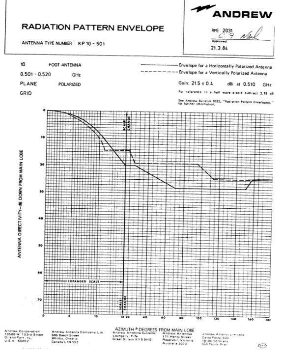
Radiation Pattern Envelope for a 3MP RCS repeater antenna
Radiation Pattern Envelope for a 4MP RCS repeater antenna
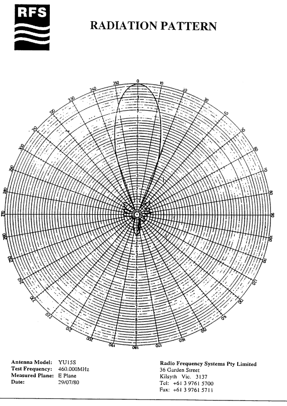
Radiation Pattern Envelope for a Yagi 15 dBi (E Plane) RCS repeater/customer antenna
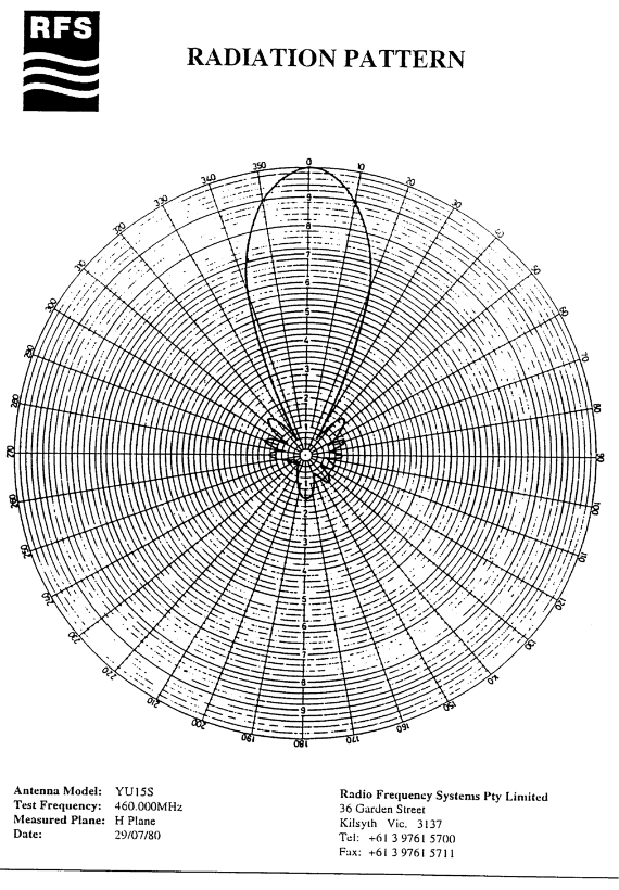
Radiation Pattern Envelope for a Yagi 15 dBi (H Plane) RCS repeater/customer antenna