Commonwealth of Australia
Great Barrier Reef Marine Park Act 1975
Shoalwater Bay (Dugong) Plan of
Management1
SB01/97
THE GREAT BARRIER REEF Marine Park AUTHORITY, having regard to the
protection of world heritage values of the Great Barrier Reef Marine Park,
and the precautionary principle within the meaning of section 3.5.1 of the
Intergovernmental Agreement on the Environment (a copy of which is set out
in the Schedule to the National Environment Protection Council Act 1994), has
prepared the following plan of management under Part VB of the Great
Barrier Reef Marine Park Act 1975.
Dated 20th of February 1997.
Dr Ian Mc Phail
Chairperson
Rhondda Jones Evelyn Scott Tom Tolhurst
Member Member Member
Note: The plan of management includes alterations made by the Authority
under paragraph 39ZE (3) (a) of the Act, notice of which was published in the
Commonwealth of Australia Gazette, under paragraph 39ZE (4) (a) of the Act, on
2nd of April 1997.
PART 1 | PRELIMINARY |
INTRODUCTORY NOTE
Shoalwater Bay is an area of significant regional importance for dugongs
(Dugong dugon) because it provides the most important habitat for one of the
most substantial populations of the species remaining in the southern section
of the Marine Park. The conservation of this reservoir population is regarded
as essential for the long-term viability of the regional population.
This Plan has been prepared in response to the recent decline in dugong
numbers in the southern section of the Marine Park. The Authority considers
that a major cause of this decline is the accidental capture of dugongs in mesh
nets in the Area.
This Plan provides a framework for managing use of the Area to ensure that
dugongs are managed to enable their recovery and continued protection and
conservation.
1. Citation
This Plan may be cited as the Shoalwater Bay (Dugong) Plan of
Management.
[Notes: 1. This Plan (except Part 4) commences on the day on which the notice referred to in
subsection 39ZE (4) of the Act is published in the Gazette: see Act, s. 39ZF (1).
2. Part 4 of this Plan commences on the day on which regulations made under
paragraph 66 (2) (ba) of the Act declare that the Part takes effect: see Act,
s. 39ZF (2).]
2. Interpretation
2.1 In this Plan, unless the contrary intention appears:
Act means the Great Barrier Reef Marine Park Act 1975;
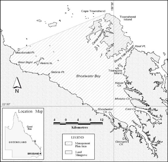
Area means the Shoalwater Bay area described in the
Schedule (and depicted generally in the map set out
in the Schedule);
cast net has the same meaning as in the Fisheries Regulation
1995 (Qld), as in force at the date of this Plan;
collecting has the same meaning as in the zoning plan;
dilly has the same meaning as in the Fisheries Regulation
1995 (Qld), as in force at the date of this Plan;
Mackay/Capricorn means the area assigned the name “Great Barrier
Section Reef Marine Park—Mackay/Capricorn Section” by
Proclamation made under subsection 31 (1) of the Act
and published in the Gazette on 24 September 1987;
[Note: For the meaning of Gazette see Acts Interpretation Act 1901, ss. 17 (m) and 46 (1) (a).]
relevant permission has the same meaning as in the Great Barrier Reef
Marine Park Regulations;
stowed or secured has the same meaning as in the zoning plan;
taking has the same meaning as in the zoning plan;
traditional hunting
and gathering has the same meaning as in the zoning plan;
zone means a zone referred to in the zoning plan;
zoning plan means the zoning plan for the Mackay/Capricorn
Section which came into force on 1 August 1988,
copies of which may be obtained from the Authority.
[Note: Unless the contrary intention appears, words and expressions used in this Plan that
are defined in the Act have the same meaning in this Plan as they do in the Act: see
Acts Interpretation Act 1901, s. 46 (1) (a). For example, the Act contains definitions of
Authority, Marine Park and vessel.]
2.2 The origin of geographical coordinates used in this Plan is the
Australian Geodetic Datum 1966 (AGD66).
2.3 The Preface, introductory notes, background notes and other notes
do not form part of this Plan, and are provided for information only.
PART 2 | MANAGEMENT ISSUES |
BACKGROUND NOTE TO PART 2
Dugongs are considered vulnerable to extinction by the World Conservation
Union. In Queensland, the dugong is listed as a vulnerable animal under the
Nature Conservation Act 1992 (Qld).
Historically, dugongs have lived in waters of the western Pacific and Indian
Oceans, but human activities have caused it to disappear in much of this
region. The majority of its world population is now believed to exist in the
tropical and sub-tropical waters of Australia, although much of this area has
not been surveyed. The estimated population of the surveyed region is
around 80,000, of which about 15% (around 12,000) live in the Marine Park.
Since 1987, dugong numbers have declined by more than half in the southern
region of the Marine Park (from Cape Bedford to Hervey Bay), which includes
the Area. The Authority considers the Area to be the most important dugong
habitat in the region.
Dugongs feed on intertidal seagrass meadows in the Area. These meadows
are also harvested for fish by fishers using mesh nets, in which at least 12
dugongs are believed to have drowned in 1994 and 1995.
Further information about dugongs, and their conservation, is set out in the
Preface (Recovery plan for dugongs in Shoalwater Bay).
3. Endangered species—dugong
For paragraph 39Y (b) of the Act, the Authority considers that
Dugong dugon (commonly known as dugong) is an endangered species in the
Area.
4. Management of use
For paragraph 39Y (c) of the Act, the Authority considers that the
netting of fish is an activity that must be managed in the Area on the basis of
ecologically sustainable use.
[Note: Section 39Y of the Act sets out the objects of plans of management. Those objects are:
(a) to ensure, for particular areas of the Marine Park in which the Authority considers
that nature conservation values, cultural and heritage values, or scientific values
are, or may be, threatened, that appropriate proposals are developed to reduce or
eliminate the threats; and
(b) to ensure that species and ecological communities that are, or may become,
vulnerable or endangered are managed to enable their recovery and continued
protection and conservation; and
(c) to ensure that activities within areas of the Marine Park are managed on the basis
of ecologically sustainable use; and
(d) to provide a basis for managing the uses of a particular area of the Marine Park
that may conflict with other uses of the area or with the values of the area; and
(e) to provide for the management of areas of the Marine Park in conjunction with
community groups in circumstances where those groups have a special interest
in the areas concerned; and
(f) to enable people using the Marine Park to participate in a wide range of
recreational activities.]
PART 3 | RELEVANT PERMISSIONS |
5. Collecting dugong
5.1 The Authority must not grant a person a relevant permission to enter
into or use a zone in the Area for the purpose of collecting dugong, unless the
collecting is for the conduct of research.
5.2 However, the Authority may grant a person a relevant permission to
enter into or use a zone in the Area for the purpose of traditional hunting and
gathering (including the traditional hunting and gathering of dugong).
PART 4 | ENFORCEMENT PROVISIONS |
INTRODUCTORY NOTES TO PART 4
1. Regulations may be made providing for giving effect to the enforcement
provisions of a plan of management or to the enforcement provisions of an
amendment of a plan of management: see Act, paragraph 66 (2) (ba).
2. The Act provides for offences in relation to:
(a) the use or entry of a zone for a purpose other than a purpose
permitted under a zoning plan; or
(b) the use or entry of a zone without a relevant permission where
permission is required under the zoning plan; or
(c) the contravention of a condition to which a relevant permission is
subject.
See Act, ss. 38A, 38B and 38C.
6. Restrictions on the use of nets in the Area
6.1 This clause does not apply to a person who uses or enters the Area
only for a purpose mentioned in paragraph 16 (a) or (b) of the zoning plan.
[Note: Clause 16 of the zoning plan relevantly provides that a zone or designated area may
be used or entered for the purpose of :
“(a) saving human life or avoiding the risk of injury to a human being;
(b) locating or securing the safety of an aircraft, vessel or structure which is, or may
be, endangered by stress of weather or by navigational or operational hazards;”.]
6.2 A person must not have in the Area a net that is capable of being
used for the taking of fish.
6.3 However, a person may have in the Area a net that is capable of
being used for the taking of fish if:
(a) the person has a relevant permission granted for the conduct of
research; or
(b) the net is part of a dilly for use only to catch crabs; or
(c) the net is a cast net that:
(i) is for use only to catch fish for bait; and
(ii) is not more than 6 metres in diameter; and
(iii) has a mesh size of not more than 28 millimetres.
6.4 A person must not have more than 1 cast net in the Area at any time.
6.5 To avoid doubt, a person may be taken to have a net in the Area
whether or not the net is stowed or secured.
7. Collecting dugongs
A person must not collect a dugong in the Area except in accordance
with a relevant permission.
8. Interference with dugongs
8.1 A person must not interfere with a dugong, or the carcass of a
dugong, in the Area, except in accordance with a written authority given by
the Authority.
8.2 In this clause, “interfere with” does not include collect, whether by
traditional hunting and gathering or by other means.
| SCHEDULE subclause 2.1 |
SHOALWATER BAY AREA
The Area is that part of the Marine Park bounded by a line:
(a) commencing at the easternmost intersection of the coastline of the
mainland at low water by the parallel of latitude 22°19’38.6” south
(that is, at Macdonald Point); and
(b) running then generally north-easterly along the geodesic to the
westernmost intersection of the coastline of Swan Island at high water
by the parallel of latitude 22°19’19.8” south; and
(c) then generally northerly, easterly and southerly along the coastline of
that island at high water to the easternmost intersection of that
coastline by the parallel of latitude 22°19’19.8” south; and
(d) then generally north-easterly along the geodesic to the northernmost
intersection of the coastline of Townshend Island at low water by the
meridian of longitude 150°28’42.0” east, in the vicinity of Cape
Townshend; and
(e) then generally south-easterly, southerly, south-easterly and southerly
along the eastern coastline of Townshend Island at low water to the
easternmost intersection of that coastline by the parallel of latitude
22°17’50.8” south; and
(f) then generally southerly along the geodesic to the northernmost
intersection of the coastline of the mainland at low water by the
meridian of longitude 150°33’55.1” east, in the vicinity of Reef Point;
and
(g) then generally south-westerly, southerly, south-easterly, westerly and
north westerly along that coastline at low water to the point of
commencement.
Map of Area
____________________________________________________________________
NOTE
1. Notified in the Commonwealth of Australia Gazette on 2nd of April 1997.