Schedule 1 Amendments
(section 3)
[1] Schedule 1, Part 3, note
omit
[2] Schedule 1, after Part 3
insert
Part 4 Antarctic specially protected area No. 104
1 Name and location
Sabrina Island, Northern Ross Sea, Antarctica.
Latitude 66 55 S, longitude 163 19 E.
2 Description
Sabrina Island is located in the Balleny Islands which are approximately 325 km north of the Pennell Coast in Northern Victoria Land. The Balleny Islands are the exposed portion of a volcanic seamount chain. There are 3 main islands and a number of smaller islands and exposed rocks. Sabrina Island is 3 km off the southern end of Buckle Island (the central of the main islands). Sabrina Island is less than 2 km across and reaches an estimated height of 180 m above sea level. A volcanic plug approximately 80 m high, named the Monolith, is attached to the southern end of Sabrina Island by a boulder spit. A small islet lies to the north east of Sabrina Island, commonly known as Chinstrap Islet. The ASPA comprises all of Sabrina Island above sea level, including the Monolith, and Chinstrap Islet.
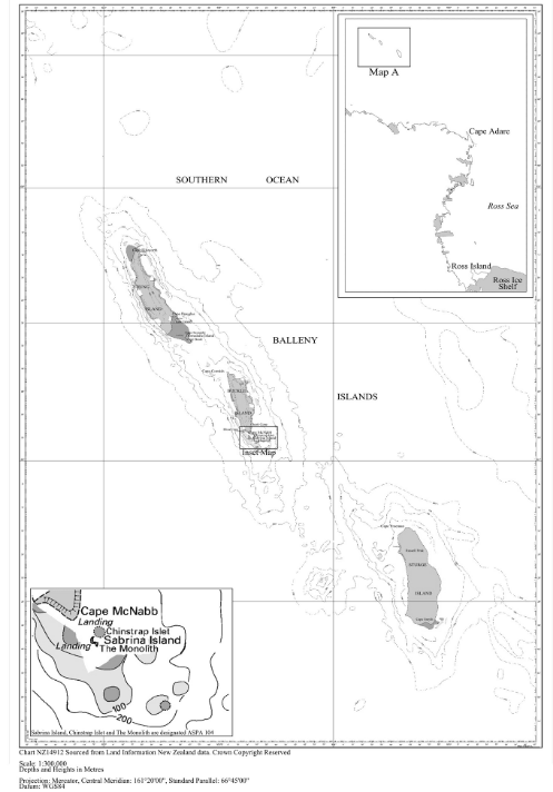 3 Map
3 Map
[3] Schedule 1, Part 13
substitute
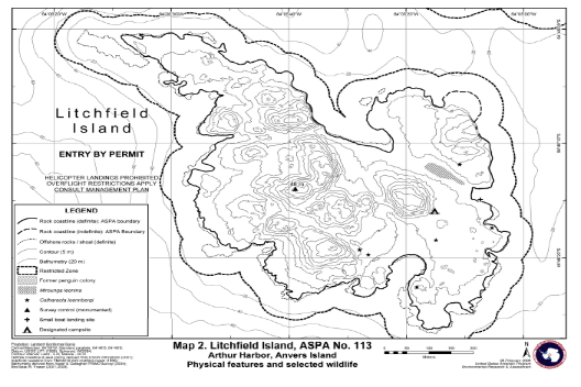
Part 13 Antarctic specially protected area No. 113
1 Name and location
Litchfield Island, Arthur Harbour, Anvers Island, Palmer Archipelago.
Latitude 64° 46′ 15 S, longitude 64° 05′ 40 W.
2 Description
Approximate area is 2.7 km2. Litchfield Island is designated on the grounds that, together with its littoral zone, it possesses an unusually rich collection of marine and terrestrial life, is unique among the neighbouring islands as a breeding place for 6 species of native birds and provides an outstanding example of the natural ecological system of the Antarctic Peninsula area.
Litchfield Island is situated in Arthur Harbor approximately 1 500 m west of Palmer Station (United States of America), Gamage Point, Anvers Island, in the region west of the Antarctic Peninsula known as the Palmer Archipelago. Litchfield Island is 1 of the largest islands in Arthur Harbor, measuring approximately 1 000 m north-west to south-east and 700 m from north-east to south-west.
The designated ASPA is defined as all of Litchfield Island above the low tide water level, excluding all offshore islets and rocks. The coast itself is a clearly defined and visually obvious boundary feature, so boundary markers have not been installed.
3 Map
[4] Schedule 1, Part 21
substitute
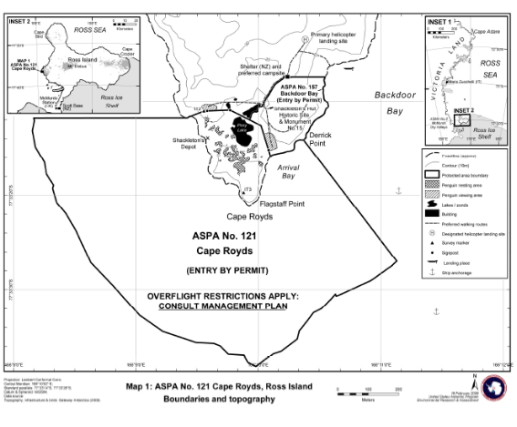
Part 21 Antarctic specially protected area No. 121
1 Name and location
Cape Royds, Ross Island.
Latitude 77 33 20 S, longitude 166 09 56 E.
2 Description
Cape Royds is situated at the western extremity of Ross Island, McMurdo Sound, on a coastal strip of ice-free land approximately 8 km wide, on the lower western slopes of Mount Erebus. The ASPA comprises both a terrestrial and marine component.
The terrestrial component of the ASPA consists of ice-free land within approximately 350 m of Flagstaff Point (166° 09 55 E, 77° 33 21 S) that is seasonally occupied by a breeding Adélie penguin (Pygoscelis adeliae) colony. The boundary includes all of the area occupied by breeding penguins and the main southern route used by the penguins to access the sea. The northern boundary of the terrestrial component of the ASPA extends from a small embayment at the north-western corner of the ASPA for 45 m in a straight line north-east to a survey mark identified on earlier New Zealand maps as IT2 (166° 09 33.3 E, 77° 33 11.1 S), which is an iron tube embedded in the ground. The boundary then extends 10 m east from IT2 to a signpost (166° 09 34.8 E, 77° 33 11.1 S), then a further 80 m east to a signpost (166° 09 46.1 E, 77° 33 11 S) south of a small pond north of Pony Lake. From this signpost the boundary extends in a south-easterly direction for 114 m north of Pony Lake to the eastern shore of the lake (166° 10 01.3 E, 77° 33 12.6 S). The north-eastern boundary then extends 86 m in a south-south-easterly direction to a third signpost (166° 10 05 E, 77° 33 15.2 S), then to the coast at Arrival Bay (166° 10 06 E, 77° 33 15.9 S). The north-eastern boundary then extends along the coastline from Arrival Bay to Derrick Point. The boundary from Pony Lake to Derrick Point is coincident with the southern boundary of ASPA No. 157 (Backdoor Bay), which has been designated to protect the hut at Cape Royds which is declared to be an historic site or an historic monument (site number 15 of Schedule 1 to the Antarctic Treaty (Environment Protection — Historic Sites and Monuments) Proclamation 2007.
The marine component of the ASPA encompasses the area within 500 m of the mean high water coastline of Flagstaff Point, with the boundary extending 500 m south-east from Derrick Point (166° 10 22 E, 77° 33 14.1 S) to the south-eastern corner of the ASPA at 166° 11 08 E, 77° 33 27 S, then westward maintaining a distance of 500 m from the shore to 166° 08 10 E, 77° 33 11.8 S, then due east 500 m to the coast at the north-western corner of the ASPA (166° 9 25 E, 77° 33 11.8 S).
3 Map
[5] Schedule 1, Part 24
substitute
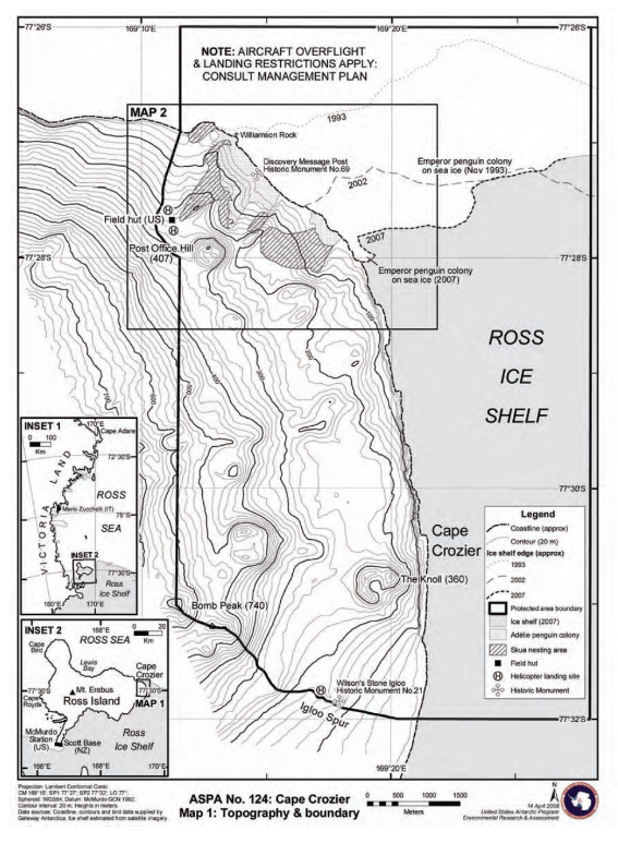
Part 24 Antarctic specially protected area No. 124
1 Name and location
Cape Crozier, Ross Island.
Latitude 77 30 30 S, longitude 169 21 30 E.
2 Description
Cape Crozier is at the eastern extremity of Ross Island, where an ice-free area comprises the lower eastern slopes of Mount Terror. The designated area is situated in the vicinity of Post Office Hill (407 m), extending to encompass the adjacent Ross Ice Shelf where large cracks in the shelf are covered by fast ice which is occupied annually by breeding Emperor penguins.
The ASPA includes a terrestrial region and ice shelf above the mean high water mark as well as the adjacent fast ice within the boundaries occupied by breeding Emperor penguins. The north boundary of the ASPA extends 6.5 km along the 77° 26 00 S line of latitude from 169° 11 30 E to 169° 28 00 E.
The west boundary extends 1.5 km south from the northern boundary to the coast, then in a south-westerly direction following a low ice-free ridge that passes 30 m west of the hut and helicopter pad. The boundary then follows this ridge in a southerly direction to the saddle south-west of the summit of Post Office Hill at 169° 11 30 E, 77° 28 00 S, before following the 169° 11 30 E line of longitude south to a point at 169° 11 30 E, 77° 31 00 S, which is close to the summit of Bomb Peak (740 m).
The boundary extends down the south-east ridge of Bomb Peak to Igloo Spur at 169° 20 00 E, 77° 32 00 S, from where it extends due east along latitude 77° 32 00 S to the east boundary at 169° 28 00 E.
3 Map
[6] Schedule 1, Part 29
substitute
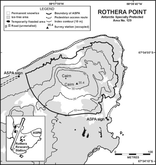
Part 29 Antarctic specially protected area No. 129
1 Name and location
Rothera Point, Adelaide Island.
Latitude 67 34 S, longitude 68 08 W.
2 Description
Rothera Point is situated in Ryder Bay, at the south-east corner of Wright Peninsula on the east side of Adelaide Island, south-west Antarctic Peninsula.
The ASPA is the north-eastern one-third of Rothera Point, and is representative of the area as a whole. It is about 280 m from west to east and 230 m from north to south, and rises to a maximum height of 36 m. At the coast, the ASPA boundary is the 5 m contour. No upper shore, littoral or sublittoral areas of Rothera Point are therefore included within the ASPA. The southern boundary of the ASPA, running across Rothera Point, is partially marked by rock filled gabions, in which are placed ASPA boundary signs. The remaining boundary is unmarked. There are 2 signboards just outside the perimeter of the ASPA located at the starting points of the pedestrian access route around Rothera Point.
3 Map
[7] Schedule 1, Parts 36 and 37
substitute
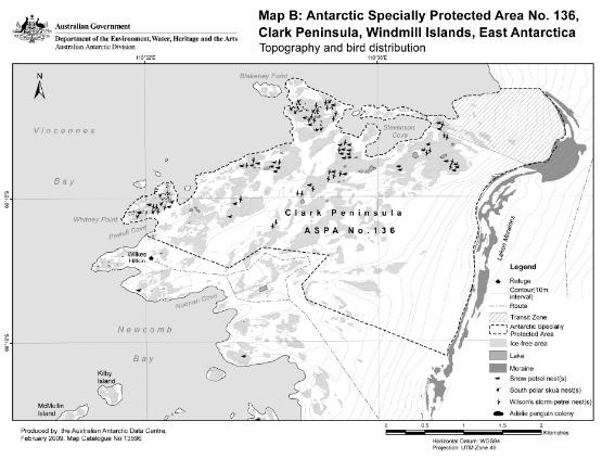
Part 36 Antarctic specially protected area No. 136
1 Name and location
Clark Peninsula, Budd Coast, Wilkes Land.
Latitude 66 15 S, longitude 110 36.
2 Description
Clark Peninsula is an area of rock exposures and permanent ice and snow fields situated on the north side of Newcomb Bay at the east end of Vincennes Bay on Budd Coast, Wilkes Land. The ASPA covers approximately 9.4 km2.
The ASPA comprises all the land on Clark Peninsula northward of the southern boundary line connecting the east side of Powell Cove at a point originating at 66° 15 15 S, 110° 31 59 E, then running:
(a) through 66° 15 29 S, 110° 33 26 E to 66° 15 21 S, 110° 34 00 E; and
(b) then through 66° 15 24 S, 110° 35 09 E to 66° 15 37 S, 110° 34 40 E; and
(c) then through 66° 15 43 S, 110° 34 45 E to a point to the east-south-east on the Løken Moraines at 66° 16 06 S, 110° 37 11 E.
The eastern boundary is the western-most limit of the Løken Moraines as far north as a point east of Blakeney Point at 66° 14 15 S, 110° 38 46, and then to the coast at 66° 14 15 S, 110° 38 06 E, returning along the coast to the point of origin. It is intended that the boundary of the ASPA will be indicated by prominent markers.
3 Map
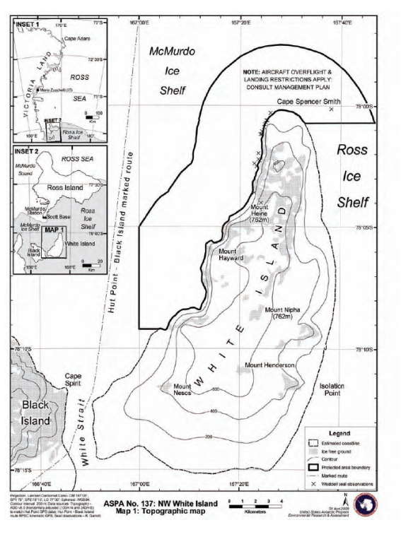
Part 37 Antarctic specially protected area No. 137
1 Name and location
North-west White Island, McMurdo Sound.
Latitude 78 07 S, longitude 167 11.
2 Description
White Island, part of the McMurdo volcanic complex, is situated approximately 20 km south-east of the edge of the McMurdo Ice Shelf and 25 km south-east of Hut Point, the location of McMurdo Station (United States of America) and Scott Base (New Zealand) on Ross Island. The roughly triangular island is approximately 30 km long and 15 km wide at its maximum, and rises to a maximum elevation of 762 m in several locations. The northern and western shores of White Island descend steeply, with water depths of 600 m occurring within 5 km of the island.
White Island is predominantly ice-covered with most of the rock outcrops being in the north, and is completely surrounded by permanent shelf ice, between 10 m and 100 m in thickness, of the McMurdo Ice Shelf and Ross Ice Shelf. Black Island is situated 2.5 km west of White Island, separated by the shelf ice of White Strait.
The ASPA includes 142 km2 of the shelf ice and open-water cracks of both the Ross Ice Shelf and McMurdo Ice Shelf up to 5 km offshore north-east, north and west from the White Island coast. The north-eastern boundary extends from the north-eastern coast of Cape Spencer-Smith (167° 32 42 E, 78° 00 43 S) 5 km due east to 167° 46 37 E, 78° 00 43 S. The boundary then extends north-west, and follows a line parallel to, and 5 km from, the coast, around Cape Spencer-Smith and then heading south-west to 167° 00 00 E, 78° 05 00 S. The boundary then extends due south for 7.8 km to 167° 00 00 E, 78° 09 12 S, and then 1.5 km east to the southern-most significant outcrop of rock on the western coast of White Island (167° 05 00 E, 78° 09 12 S). The boundary then extends northwards, following the coastline around Cape Spencer-Smith to the north-eastern limit of the ASPA.
The White Island coast is distinguished by a change in surface slope where the transition between the floating ice shelf and land occurs: the transition is in some places gradual and indistinct, and the exact position of the coast is not precisely known. For this reason the coastal (generally east) boundary of the ASPA is considered to follow the line of the coast as evidenced by a surface elevation rise towards the land of 2 m above the average elevation of the adjacent McMurdo Ice Shelf.
3 Map
[8] Schedule 1, Part 50
substitute
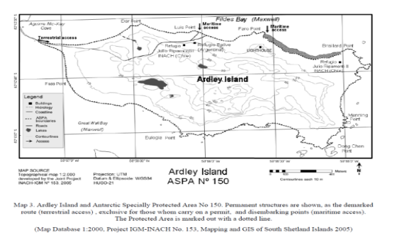
Part 50 Antarctic specially protected area No. 150
1 Name and location
Ardley Island, Maxwell Bay, King George Island.
Latitude 62 13 S, longitude 58 54W.
2 Description
Ardley Island is about 2 km south-east of the Bellingshausen Station (Russian Federation) and of the Escudero and Frei Stations (Chile), and about 2 km east of the Great Wall Station (China).
The ASPA comprises most of the island, and is linked to King George Island (Isla 25 de Mayo) by an isthmus that remains submerged at high tide. The eastern part of the isthmus, which remains dry during the high tide, is included in the ASPA because it is part of Ardley Island. However, the western part of the isthmus is outside the ASPA. The beach below the 1 m contour line in the north-eastern part of the island, from Faro Point (62 12 34 S, 58 55 34 W) until the beginning of Braillard Point (62 12 40 S, 58 55 4 W) is also outside the ASPA.
3 Map

[9] Schedule 1, Part 54
substitute
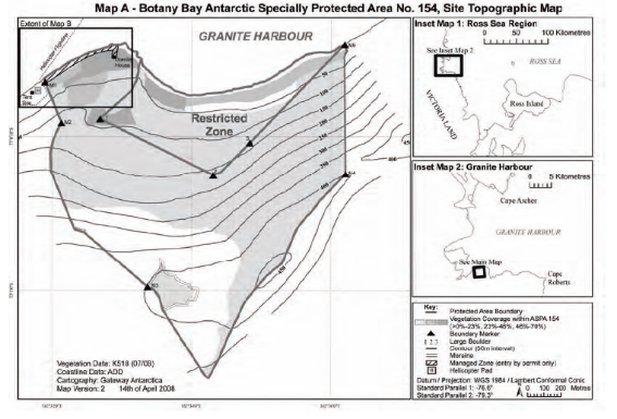
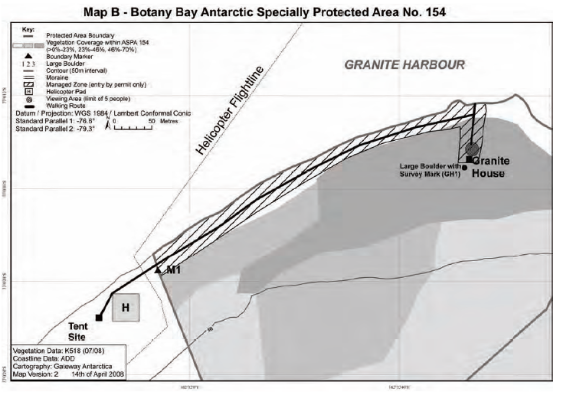
Part 54 Antarctic specially protected area No. 154
1 Name and location
Botany Bay, Cape Geology, Victoria Land.
Latitude 77 00 30 S, longitude 162 34 E.
2 Description
Cape Geology is situated in the south-western corner of Granite Harbour, southern Victoria Land, approximately 100 km north-west of Ross Island. The ASPA encompasses much of the catchment above Botany Bay and consists of raised boulder beach terraces, weathered rocky steppes and irregular rock platforms around Cape Geology, extending south to include a well-defined elevated cirque containing a small ice field.
The north-west corner of the ASPA is marked by a brass plaque in a boulder (at 2 m elevation, 162° 31 53 E, 77° 00 19 S) 400 m south-west of Cape Geology. The west boundary is defined by a line extending first 260 m south-south-east from the boulder to a large boulder (marked by a cairn) with terrier bolt at an elevation of 118 m on the ridge above the campsite; then the boundary extends 250 m up this ridge to a point at 162 m elevation marked by an iron tube with bamboo pole. The west boundary extends a further 300 m up this ridge to a large pointed rock at 255 m elevation (162° 3146 E, 77° 00 40 S) near the edge of the permanent ice field. The boundary then extends 150 m south across the ice field to the west edge of a prominent line of exposed rock and moraine in the south-western corner of the ASPA at 325 m elevation. The south boundary follows this line of rock east until the exposure is buried by the ice field, then south-east across the ice field for 500 m to the edge of a second and more prominent exposure at an elevation of just over 400 m (162° 33 22 E, 77° 00 59 S).
The boundary follows the upper edge of this exposure and then crosses the ice field south-easterly to an elevation of approximately 325 m where the ice-free eastern boundary ridge and the ice field converge (162° 34 15 E, 77° 01 16 S). The east boundary follows the ridge crest for 1 550 m in a north-easterly direction to a low point on the ridge (at 392 m elevation, 162° 36 10 E, 77° 00 13 S) where the east boundary turns to descend due north to the coast at the eastern extremity of the boulder beach of Botany Bay (at 5 m elevation). The mean high water mark of the coastline of Botany Bay and Cape Geology forms the northern boundary of the ASPA.
3 Map
[10] Schedule 1, after Part 67
insert
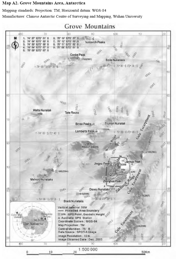
Part 68 Antarctic specially protected area No. 168
1 Name and location
Mount Harding, Grove Mountains, East Antarctica.
Latitude 72 512 S to 72 572 S, longitude 74 532 E to 75 122 E.
2 Description
The Grove Mountains are located approximately 400 km inland (south) of the Larsemann Hills in Princess Elizabeth Land, East Antarctica, on the eastern bank of the Lambert Rift. Mount Harding is the largest mount around the Grove Mountains region, and is located in the core area of the Grove Mountains that presents a ridge-valley physiognomies consisting of nunataks, trending north-north-east to south-south-west. Mount Harding is 200 m above the surface of blue ice.
The ASPA is irregular, and approximately rectangular in shape, with a width of about 10 km from east to west, a length of about 12 km from south to north and a total area of about 120 km2.
The ASPA boundary was defined to ensure that the unique geomorphological features, formed in ice sheet advance and retreat in Mount Harding, can be specially protected as a whole.
The ASPA includes the open blue ice zone from the moraine on the west side of Mount Harding to the east side of the Zakharoff Ridge as well as a number of nunataks, detritus zones and moraines within it.
The western boundary of the area is the moraine on the west side of Mount Harding, with its northern end turning eastward to the open blue ice detritus zone on the east side of the Zakharoff Ridge via the north flank of the northern ridge of Mount Harding and the northern end of the Zakharoff Ridge, turning southwards to the northern end of Davey Nunataks, and then heading westwards to the southern end of the Xi Lake moraine to close the whole area.
3 Map
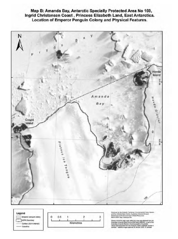
Part 69 Antarctic specially protected area No. 169
1 Name and location
Amanda Bay, Ingrid Christensen Coast, Princess Elizabeth Land, East Antarctica.
Latitude 69 15 00S, longitude 76 49 59.9 E.
2 Description
Amanda Bay lies south-west of the Brattstrand Cliffs, between the Vestfold Hills to the north-east and the Larsemann Hills to the south-west on the Ingrid Christensen Coast, Princess Elizabeth Land, East Antarctica. Amanda Bay is approximately 3 km wide and 6 km long, and opens
north-west into Prydz Bay. The south-west side of the bay is flanked by the Flatnes Ice Tongue secured by Cowell Island at its western corner. The southern and eastern sides are bounded by continental ice cliffs. There are small islets towards the centre of the bay and several unnamed islands a few kilometres offshore.
The ASPA comprises the rocks, islands and water, including fast ice, lying within an irregular area, covering the general area of Amanda Bay, commencing at a point to the north-east of Hovde Island at the terminus of the Hovde Glacier, 76° 53 54.48 E, 69° 13 25.77 S; then south along the coastline at the base of the Hovde Glacier ice cliffs, to a point at 76° 53 44.17 E, 69° 16 22.72 S; then west along the coastline at the base of a series of ice-free bluffs to a point 76° 49 37.47 E, 69° 16 58.48 S; then north along the base of the Flatnes Ice Tongue ice cliffs, to a point at the terminus of the Flatnes Ice Tongue, 76° 46 41.07 E, 69° 14 44.37 S; then a straight line in a north-easterly direction connecting with the originating point at 76° 53 54.48 E, 69° 13 25.77 S.
3 Map
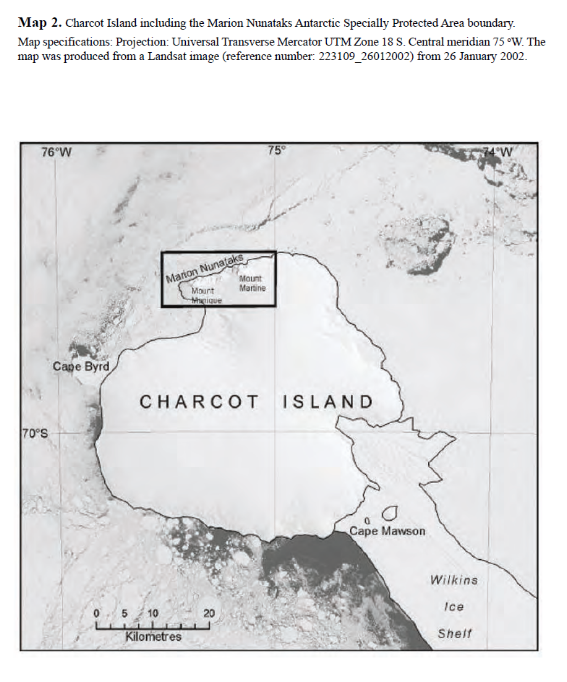
Part 70 Antarctic specially protected area No. 170
1 Name and location
Marion Nunataks, Charcot Islands, Antarctic Peninsula.
Latitude 69 45 S, longitude 75 15 W.
2 Description
Marion Nunataks lie on the northern edge of Charcot Island, a remote
ice-covered island to the west of Alexander Island, Antarctic Peninsula, in the eastern Bellingshausen Sea. Marion Nunataks form a 12 km chain of rock outcrops on the mid-north coast of the island and stretch from Mount Monique on the western end to Mount Martine on the eastern end. The ASPA is 176 km2 (maximum dimensions are 9.2 km north-south and 19.2 km east-west) and includes all of the known ice-free land on Charcot Island.
Charcot Island is roughly circular in shape, approximately 50 km across and is separated from north-west Alexander Island (approximately 100 km away) by Wilkins Sound and Wilkins Ice shelf. Charcot Island is ice-covered with the exception of Marion Nunataks, which form a 12 km chain of rock outcrops that overlook the mid-north coast of Charcot Island, and consist predominantly of steep north-facing cliffs. Mount Monique lies towards the western end of the Marion Nunataks chain and Mount Martine lies towards the eastern end. The summits of both peaks are between 750 m and 1 000 m above sea level.
The ASPA comprises the ice sheet, nunataks, rocks, sea ice and islands including Cheeseman Island (located at 69 43 24 S, 75 11 00 W) lying within a rectangle enclosed by the following coordinates:
| Latitude | Longitude |
1 | 69 43 00 | 75 30 00 |
2 | 69 43 00 | 75 00 00 |
3 | 69 48 00 | 75 30 00 |
4 | 69 48 00 | 75 00 00 |
There are no boundary markers delimiting the ASPA. The maximum dimensions of the ASPA are 9.2 km north-south and 19.2 km east-west. The ASPA does not include the marine environment below the low water mark. The protected land area is 176 km2 and includes all of the ice-free land on Charcot Island (known as at 2008). The ASPA also includes the ice cap that extends at least 4 km to the south and east of the nunataks, which is intended to act as a buffer zone to prevent accidental importation of species not native to the Area.
3 Map
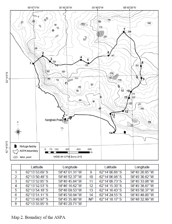
Part 71 Antarctic specially protected area No. 171
1 Name and location
Narębski Point, Barton Peninsula, King George Island.
Latitude 62 13 40 S to 62 14 23 S, longitude 58 45 25 W to 58 47 00 W.
2 Description
Narębski Point is located on the south-east coast of Barton Peninsula, King George Island. The ASPA is easily distinguished by mountain peaks on the north and the east boundaries and coastline on the southwest boundary. The south-west boundary can be easily recognised due to its distinguished geomorphology. The ASPA includes only the terrestrial area, excluding the intertidal zone. The total size of the ASPA is approximately 1 km2.
There are no structures within the ASPA. A refuge facility is located about 100 m away from the ASPA toward the south-eastern coast.
3 Map
[11] Schedule 2, after Part 4
insert
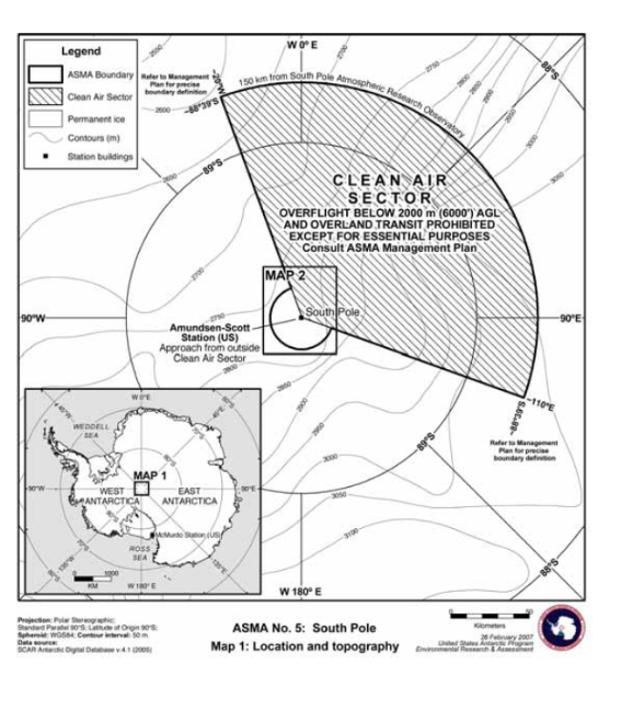
Part 5 Antarctic specially managed area No. 5
1 Name and location
Amundsen-Scott South Pole Station, South Pole.
90 S.
2 Description
The Amundsen-Scott South Pole Station (South Pole Station) is located on the polar plateau near the geographic South Pole, at 90° S. An area of approximately 26 400 km2 encompassing the station and long-term research and monitoring sites is designated as an ASMA to manage human activities for the protection of scientific, environmental, and historical values.
The boundary of the ASMA comprises all structures and areas of current and planned research at South Pole Station and a buffer area for the Clean Air Sector (CAS). The boundary of the ASMA is a circle around South Pole Station with a radius of 20 km, and a wedge extending 150 km from the Atmospheric Research Observatory (ARO) building (approximately 0.5 km from the 2005 Geographic South Pole), bounded by 110° and 340° (grid) from the ARO building. The point of origin of the ASMA and sectors (other than the CAS) was designated as the circular aluminium tower staircase on the elevated station, as this is a readily recognizable feature on the maps and on the ground, and the elevated station is expected to be present in the ASMA longer than any other structure or landmark.
Due to the movement of the ice sheet in the area, the geographic location of the ASMA will move approximately 10 m per year; the area is centred on the elevated South Pole Station, and all sectors are relative to this location.
3 Map
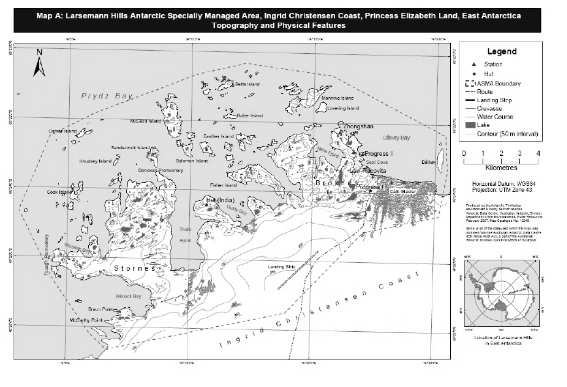
Part 6 Antarctic specially managed area No. 6
1 Name and location
Larsemann Hills, East Antarctica.
Latitude 69 30 S, longitude 76 19 58 E.
2 Description
The Larsemann Hills is an ice-free area of 40 km2, located approximately halfway between the Vestfold Hills and the Amery Ice Shelf on the south‑eastern coast of Prydz Bay, Princess Elizabeth Land, East Antarctica. The ice-free area consists of two major peninsulas (Stornes and Broknes), four minor peninsulas, and approximately 130 near shore islands. The eastern-most peninsula, Broknes, is further divided into western and eastern components by Nella Fjord. The closest significant ice-free areas are the Bølingen Islands (69 31 58 S, 75 42 E) 25 km to the south-west and the Rauer Islands (68 50 59 S, 77 49 58 E) 60 km to the north-east.
The ASMA comprises the ice-free area and near-shore islands collectively known as the Larsemann Hills and the adjacent plateau. The ASMA includes the land beginning at the point of 69 23 20 S, 76 31 0 E east of the southern tip of Dalkoy and running:
(a) north to 69 22 20 S, 76 30 50 E, north of Dalkoy; and
(b) then north-west to 69 20 40 S, 76 21 30 E, north of Striped Island; and
(c) then north-west to 69 20 20 S, 76 14 20 E, north-east of Betts Island; and
(d) then south-west to 69 20 40 S, 76 10 30 E, north-west of Betts Island; and
(e) then south-west to 69 21 50 S, 76 2 10 E, north-west of Osmar Island; and
(f) then south-west to 69 22 30 S, 75 58 30 E, west of Osmar Island; and
(g) then south-west to 69 24 40 S, 75 56 0 E, west of Mills Island; and
(h) then south-east to 69 26 40 S, 75 58 50 E, south of Xiangsi Dao; and
(i) then south-east to 69 28 10 S, 76 1 50 E, south-west of McCarthy Point; and
(j) then south-east to the coastline at 69 28 40 S, 76 3 20 E; and
(k) then north-east to 69 27 32 S, 76 17 55 E, south of the Russian airstrip site; and
(l) then south-east to 69 25 10 S, 76 24 10 E, on the western side of the Dålk Glacier; and
(m) then north-east to 69 24 40 S, 76 30 20 E, on the eastern side of the Dålk Glacier; and
(n) then north-east returning to 69 23 20 S, 76 31 0 E.
3 Map
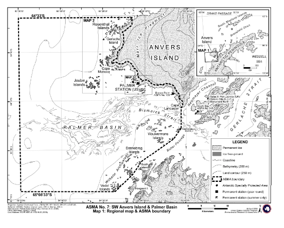
Part 7 Antarctic specially managed area No. 7
1 Name and location
South-west Anvers Island and Palmer Basin.
Latitude 64 50 S, longitude 54 30 W.
2 Description
The region that includes South-west Anvers Island and the Palmer Basin and its fringing island groups has a wide range of important natural, scientific and educational values and is an area of considerable and increasing scientific, tourist and logistic activities.
The ASMA comprises an area of approximately 3 275 km2, including both terrestrial and marine components. For ease of navigation, the boundaries of the ASMA follow geographic features where practical and latitude and longitude lines in open ocean areas remote from prominent land features. The north-eastern boundary of the ASMA is defined as a line extending parallel to, and approximately 1 km inland from, the South-west Anvers Island coastline. This terrestrial boundary extends from a northerly location at 64° 33 00 S, 64° 06 03 W, approximately 3.1 km north of Gerlache Island, to 64° 51 21 S, 63° 42 36 W at Cape Lancaster in the south.
From Cape Lancaster, the eastern boundary is defined as the 63° 42 36 W line of longitude extending 7.9 km across Bismarck Strait to 64° 55 36 S on Wednesday Island, the most easterly of the Wauwermans Islands. The boundary then follows a general south-westerly direction to 65° 08 33 S, 64° 14 22 W at the southern extremity of the Vedel Islands, following the eastern coastlines of the Wauwermans, Dannebrog and Vedel island groups. The southern boundary of the area is defined as the 65° 08 33 S line of latitude extending due west from 64° 14 22 W in the Vedel Islands to 65° 00 00 W.
The northern boundary is defined as the line of latitude extending from 64° 33 00 S, 64° 06 03 W to the coast (approximately 3.1 km north of Gerlache Island) and then due west to the 65° 00 00 W line of longitude. The western boundary of the Area is defined as the 65° 00 00 W line of longitude, extending between 64° 33 S in the north and 65° 08 33 S in the south.
3 Map