Schedule 1 Amendments
(section 3)
[1] Schedule 1, Parts 5 and 6
substitute
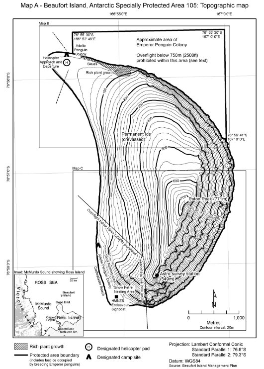
Part 5 Antarctic specially protected area No. 105
1 Name and location
Beaufort Island, McMurdo Sound, Ross Sea.
Latitude 76 56 S, longitude 166 56 E.
2 Description
Beaufort Island is the northern most feature of the Ross Archipelago, lying 19 km north of Cape Bird, Ross Island. It is a portion of the rim of a volcanic cone, the remainder of which has eroded away and is now submerged to the east of the island. The island, and the remains of the submerged caldera, block the predominantly westward drift of pack ice and icebergs calving from the nearby Ross Ice Shelf. Grounded icebergs facilitate fast ice growth. Beaufort Island is predominantly rock but portions are ice and snow covered. On the south-west side of the island there is a broad ice-free shelf with raised beaches behind which summer ponds form, fed by small meltwater streams draining to the coast. Sloping ice fields cover much of the west and north side of the island but the ice is receding. An extensive flat area of less than 50 m above sea level is at the north end of the island, where the ice cap of the island drains to a boulder beach. The eastern side of the island facing the centre of the caldera is made up of near vertical cliffs.
The protected area encompasses the whole of Beaufort Island above the mean high water mark, and includes adjacent fast-ice occupied by breeding Emperor penguins. The coordinates of the fast-ice component of the Area are:
from the northern coast of Beaufort Island at 76° 5544 S, 166° 52 42 E north to 76° 55 30 S, 166° 52 49 E;
from 76° 55 30 S, 166° 52 49 E east to 76° 55 30 S, 167° 00 E;
from 76° 55 30 S, 167° 00 E south along the 167° longitude parallel to where it intersects with the coastline of Beaufort Island at 76° 55 30 S, 167° E.
3 Map
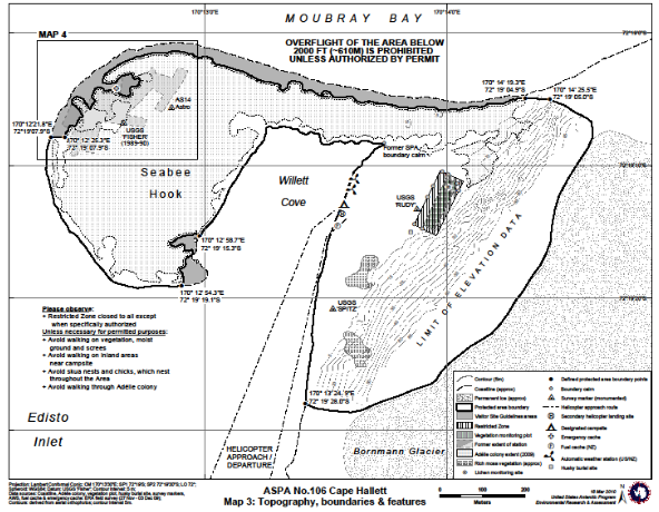
Part 6 Antarctic specially protected area No. 106
1 Name and location
Cape Hallett, Northern Victoria Land, Ross Sea.
Latitude 170° 13 25 E, longitude 72° 19 11 S.
2 Description
The Cape Hallett Area is at the northern end of the Hallett Peninsula, northern Victoria Land, and has an approximate area of 0.53 km2. Cape Hallett is located at the southern end of Moubray Bay, in the western Ross Sea. The Area occupies most of the ice‑free ground of a cuspate spit of low elevation known as Seabee Hook and includes the adjacent western slopes of the northern end of Hallett Peninsula, east of Willett Cove to the margin of the permanent glaciers.
The northern boundary of the Area extends along the northern coast of Seabee Hook from 170° 14 25.5 E, 72° 19 05.0 S to the eastern limit of the Adélie colony at 170° 14 19.3 E, 72° 19 04.9 S. The boundary then follows the edge of the nesting area of the Adélie colony, maintaining a distance of at least 5 m from the colony, extending to 170° 12 25.3 E, 72° 19 07.9 S.
From 170° 12 25.3 E, 72° 19 07.9 S, the boundary extends 33 m due west to the coast at 170° 12 21.8 E, 72° 19 07.9 S and then continues southward to follow the western and southern coastline of Seabee Hook to 170° 12 54.3 E, 72° 19 19.1 S, which is near the south-eastern end of the spit. The boundary extends northward, following the edge of the nesting area, maintaining a distance of at least 5 m from the colony, in the south‑eastern part of Seabee Hook to 170° 12 58.7 E, 72° 19 15.3 S. The boundary of the Area continues northward to follow the low water shoreline along the eastern coast of Seabee Hook, and then follows the low water coastline around Willett Cove to the southern boundary at 170° 13 24.9 E, 72° 19 28.0 S.
From 170° 13 24.9 E, 72° 19 28.0 S, the boundary extends eastward to the Bornmann Glacier, following a seasonal stream which descends from the glacier. The eastern boundary of the Area then follows the glacier and permanent ice margin northward at elevations between about 120 m and 150 m above sea level, crossing the steep western slopes of Hallett Peninsula and following the upper outcrops of a series of rocky ridges dissecting the slope. The boundary then descends to join the northern coastline of Seabee Hook at the base of a rock buttress at 170° 14 25.5 E, 72° 19 05.0 S.
3 Map
[2] Schedule 1, Part 22
substitute
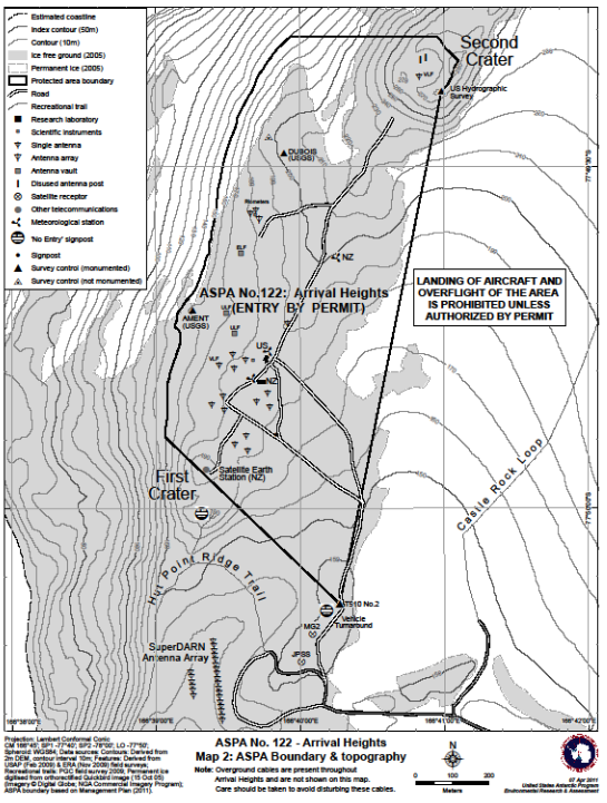
Part 22 Antarctic specially protected area No. 122
1 Name and location
Arrival Heights, Hut Point Peninsula, Ross Island.
Latitude 77° 49 41.2 S, longitude 166° 40 2.8 E.
2 Description
Arrival Heights is a small range of low hills located near the south-western end of Hut Point Peninsula, Ross Island and has an approximate area of 0.73 km2. Hut Point Peninsula is made up of a series of volcanic craters extending from Mount Erebus, two of which, namely First Crater and Second Crater, respectively form part of the southern and northern boundaries of the Area. The Area is predominantly ice-free and elevations range from 150 m to 280 m above sea level at Second Crater. Arrival Heights is located about 1.5 km north of McMurdo Station and 2.7 km north-west of Scott Base. The Area has a broad viewing horizon and is comparatively isolated from activities at McMurdo Station and Scott Base, with the majority of McMurdo Station being hidden from view.
The south-eastern boundary corner of the Area is defined by Trig T510 No. 2, the centre of which is at 77° 50 08.4 S, 166° 40 16.4 E at an elevation of 157.3 m above sea level. Trig T510 No. 2 replaced, and is 0.7 m from, the former boundary survey marker (T510), which no longer exists. The T510 No. 2 marker is an iron rod (painted orange) in the ground about 7.3 m west of the access road to Arrival Heights, and is surrounded by a small circle of rocks. The boundary of the Area extends from Trig T510 No. 2 in a straight line 656 m north-west over First Crater at 77° 49 53.8 S, 166° 39 03.9 E, at 150 m above sea level. The boundary follows the 150 m contour northward for 1 186 m to 77° 49 18.6 S, 166° 39 56.1 E, which is due west of the northern rim of Second Crater. The boundary extends 398 m due east to Second Crater, and around the crater rim to a US Hydrographic Survey marker (a stamped brass disk) which is installed near the ground at 77° 49 23.4 S, 166° 40 59.0 E and 282 m above sea level, forming the north-eastern boundary of the Area. The boundary extends from the US Hydrographic Survey marker southward for 1 423 m in a straight line directly to Trig T510 No. 2.
3 Map
[3] Schedule 1, Part 26
substitute
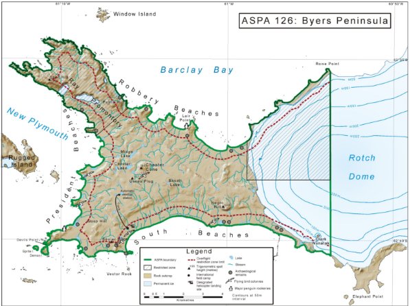
Part 26 Antarctic specially protected area No. 126
1 Name and location
Byers Peninsula, Livingston Island, South Shetland Islands.
Latitude 62 34 35 S, longitude 61 13 07 W.
2 Description
The Area is made up of Byers Peninsula, all ice-free ground and ice sheet west of longitude 60 53 45 W (including Clark Nunatak and Rowe Point), the near-shore marine environment extending 10 m offshore from the low tide water line, and Demon Island and Sprite Island adjacent to the southern shoreline of Devils Point. The Area does not include all other offshore islets, including Rugged Island, and rocks.
The linear eastern boundary follows longitude 60 53 45 W to ensure newly exposed ice-free ground resulting from the retreat of Rotch Dome, which may contain scientifically useful opportunities and new habitats for colonisation studies, is within the boundaries of the Area. No boundary markers are in place.
Byers Peninsula, between latitudes 62° 34 35 and 62° 40 35 S and longitudes 60 53 45 and 61° 13 07 W, is 84.7 km2 in area and is located at the west end of Livingston Island, the second-largest of the South Shetland Islands. The ice-free area on the peninsula has a central west-east extent of about 9 km and a north-west south-east extent of 18.2 km, and is the largest ice‑free area in the South Shetland Islands.
3 Map
[4] Schedule 1, Part 31
substitute
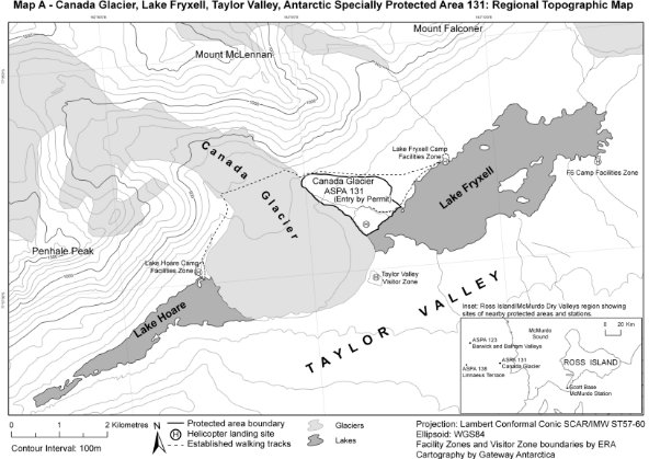
Part 31 Antarctic specially protected area No. 131
1 Name and location
Canada Glacier, Lake Fryxell, Taylor Valley, Victoria Land.
Latitude 77° 37 S, longitude 163° 03 E.
2 Description
Canada Glacier is located in the Taylor Valley, in the McMurdo Dry Valleys. The Area includes most of the glacier forefront area on the east side of the lower Canada Glacier, on the north shore of Lake Fryxell. It comprises gently to moderately sloping ice-free ground at an elevation of 20 m to 220 m above sea level with seasonal melt water ponds and streams draining Canada Glacier into Lake Fryxell.
The southern boundary of the Area is defined as the shoreline of Lake Fryxell to the water’s edge. This boundary extends north-east for about 1 km along the shoreline from the north-east corner of the boundary of where the Canada Glacier meets Lake Fryxell at 77° 37.20 S, 163° 3.64 E to the south-east corner of the boundary which is marked with a cairn at 77° 36.83 S, 163° 4.88 E. The cairn is adjacent to a small island in Lake Fryxell. The island was once a part of a small peninsula extending into Lake Fryxell but lake level rise has turned it into an island. The peninsula was once marked by a large split rock surrounded by a circle of rocks which was a benchmark for the 1985 NZ survey of the original Site of Special Scientific Interest (SSSI), but is no longer visible. A wooden post marking the Dry Valley Drilling Project Site 7 (1973) is visible on the island.
A moraine ridge extending northward upslope from the south-east corner of the boundary defines the eastern boundary of the Area. A cairn is located at 77° 36.68 S, 163° 4.40 E on a knoll on the ridge 450 m from the south-east corner of the boundary. The ridge dips sharply before joining the featureless slope of the main Taylor Valley wall. The north-east boundary corner of the Area is in this dip and is marked by a cairn at 77° 36.43 S, 163° 3.73 E.
From the north-east boundary cairn, the northern boundary slopes gently upwards and west for 1.7 km to Canada Glacier, to the point where the stream flows from the glacier and snow field, through a narrow gap in the moraine at 77° 36.42 S, 162° 59.69 E.
The western boundary follows the glacier edge for about 1 km down a slope of lateral moraine of fairly even gradient to the south-west corner of the boundary where the glacier meets the lake shore at 77° 37.20 S, 163° 3.64 E.
3 Map
[5] Schedule 1, Part 59
substitute
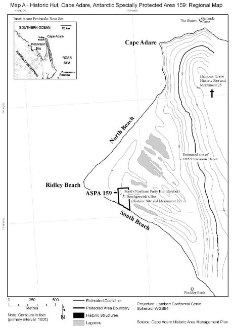
Part 59 Antarctic specially protected area No. 159
1 Name and location
Cape Adare, Borchgrevink Coast.
Latitude 71° 19 S, 170° 12 E.
2 Description
Cape Adare is a generally ice-free, prominent volcanic headland, at the northern end of Victoria Land, which marks the western approaches to the Ross Sea. The Area is located to the south-west of the Cape on the southern shore of Ridley Beach, which encloses a large, flat, triangular area of shingle.
The northern boundary of the Area is an east-west line 50 m north of the Northern Party Hut. The eastern boundary of the Area is a north-south line 50 m east of Borchgrevink’s stores hut. The north-east corner of the boundary is at 71° 18.502 S, 170° 11.735 E and the south‑east corner of the boundary is at 71° 18.633 S 170° 11.735 E. The western boundary of the Area is a north-south line 50 m west of Borchgrevink’s living hut. The north-west corner of the boundary is at 71° 18.502 S, 170° 11.547 E and the south-west corner of the boundary is at 71° 18.591 S, 170° 11.547 E. The southern boundary is the high tide mark of Ridley Beach.
3 Map
[6] Schedule 2, Part 2
substitute
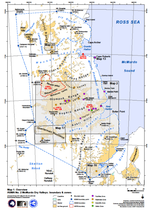
Part 2 Antarctic specially managed area No. 2
1 Name and location
McMurdo Dry Valleys, Southern Victoria Land.
Latitude 77 S, longitude 162 E.
2 Description
The boundaries of the Area have been defined primarily on the basis of the hydrological catchments in the McMurdo Dry Valleys, including all of the ice-free ground and adjacent areas within these catchments, all of the Convoy Range in the north, and bounded by the Koettlitz Glacier in the south. Offshore islands, except Tripp Island in the north and Heald Island in the south, are not included within the Area.
The boundary of the Area extends from the north-eastern end of Tripp Island at 76° 38.09 S, 162° 42.90 E continuing southward following the coastline at the mean low tide level to DeMaster Point (situated east of Marshall Valley at 78° 04.20 S, 164° 25.43 E), a distance of about 170 km. The boundary follows the north-western margin of the Koettlitz Glacier south-westward for about 25 km to Walcott Bay and Trough Lake, including within the Area all of the streams and lakes along the glacier margin. The boundary follows the approximate southern grounding line of the Koettlitz Glacier margin in Walcott Bay, extending east towards The Bulwark and encompassing all of Trough Lake. The boundary continues east following Bulwark Stream for about 1.5 km to the northern extremity of The Bulwark. The boundary extends 3 km in a straight line north-east to the north-western coastline of Heald Island following the northern coastline to the eastern extremity of the island at 78° 15.00 S, 163° 57.80 E.
The boundary extends from Heald Island about 14.8 km south-west to the summit of The Pyramid (854 m) at 78° 20.64 S, 163° 29.95 E. The boundary continues south-west about 13.3 km to the foot of Highway Ridge at 78° 23.97 S, 162° 58.57 E from where it follows up the ridgeline north‑westward for about 3.8 km to the summit of Shark Fin (2 242 m) at 78° 22.11 S, 162° 54.66 E. The boundary extends from Shark Fin north‑west about 6.7 km to the summit of Mount Kempe (3 004 m) at 78° 19.35 S, 162° 43.18 E. The boundary continues north-west in a straight line from the summit of Mount Kempe about 83 km to the summit of Mount Wisneski (2 320 m) at 77° 57.65 S, 159° 33.73 E, which is the most southerly peak of the Lashley Mountains.
From Mount Wisneski, the boundary extends northwards for about 8.7 km to Mount Crean (2 550 m) at 77° 53.00 S, 159° 30.66 E, the highest peak in the Lashley Mountains. The boundary continues 5.6 km northward to the summit of Mount Koger (2 450 m) at 77° 50.05 S, 159° 33.09 E, the most northerly peak in the Lashley Mountains.
The boundary extends north-east about 15.3 km to Depot Nunatak (1 980 m) at 77° 44.88 S, 160° 03.19 E and north-west about 19.6 km to the western end of the ice-free ground at Horseshoe Mountain at 77° 34.52 S, 159° 53.72 E. The boundary continues north about 40 km to the summit of Mount DeWitt (2 190 m) at 77° 13.05 S, 159° 50.30 E, then extends north‑west about 38.4 km to the summit of Carapace Nunatak (2 321 m) at 76° 53.31 S, 159° 23.76 E and continues 39 km north to the summit of Battlements Nunatak (2 128 m) at 76° 32.27 S, 159° 21.41 E.
The boundary extends east from Battlements Nunatak about 51 km to the summit of Mount Douglas (1 750 m) at 76° 31.25 S, 161° 18.64 E and then about 18 km south-eastward to the summit of Mount Endeavour (1 870 m) at 76° 32.49 S, 161° 59.97 E. The boundary extends south-east from Mount Endeavour about 21.3 km to the north-eastern end of Tripp Island.
The principal basis for the coordinates given above is the USGS/LINZ 1:50 000 digital base map prepared for the McMurdo Dry Valleys, which has an estimated maximum error of +/- 50 m. Because this map does not extend to cover the western boundary, coordinates in these areas are from the USGS 1:250 000 map, with an estimated maximum error of +/- 200 m. Accurate mapping with a maximum error of +/- 2 m is available for a limited number of sites within the Area, mostly in the Taylor Valley, and accurate GPS coordinates are available to describe only parts of the boundaries. The 1:50 000 series was selected as the primary map base for boundary coordinates to ensure that these are given using a map datum that is defined to a consistent standard over most of the Area. For these reasons, GPS coordinates for the boundaries are likely to differ from the coordinates given above by up to 50 m, or in the west by up to about 200 m.
3 Map