Figure 1. Major pre-1900 lighthouses in the Great Barrier Reef Region
Figure 2. Contract drawing of Lady Elliot Island lighthouse, signed in 1872
Figure 3. Lady Elliot Island lighthouse and cottage, undated
Figure 4. Lady Elliot Island cottages, undated
Figure 5. AMSA navigation tower, Lady Elliot Island
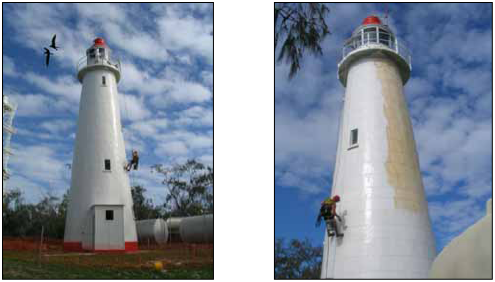
Figure 6. Lighthouse maintenance in 2007
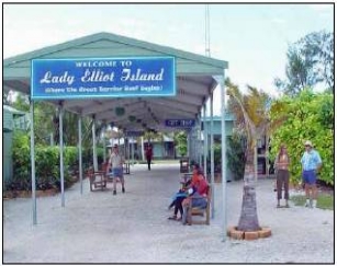
Figure 7. Lady Elliot Island Eco Resort
Figure 8. AMSA navigation tower, Lady Elliot Island
Figure 9. Map of Lady Elliot Island showing property information and identified uses
Figure 10. Map of Lady Elliot Island Lightstation Heritage Management Plan Area
Figure 11. Lady Elliot Island lighthouse and residential precincts
Figure 12. Lady Elliot Island lightstation site plan
Lady Elliot Island lightstation was placed on the Commonwealth Heritage List in 2004. The lighthouse, built in 1873, demonstrates a rare construction method used in lighthouses in Australia. It is also significant because it represents an important landmark indicating the southern end of the Great Barrier Reef Marine Park. The construction of navigational aids is also a part of the story of development along the coastal regions of Queensland after its separation from New South Wales.
The Environment Protection and Biodiversity Conservation Act 1999 requires that each Commonwealth agency that owns or controls a Commonwealth Heritage listed place must make a written management plan to protect and manage the Commonwealth Heritage values of the place.
The Lady Elliot Island Lightstation Heritage Management Plan describes and assesses the heritage values of this Commonwealth Heritage place, as well as detailing those obligations, appropriate policies and management regimes required to ensure that these heritage values are managed and protected.
Lady Elliot Island lightstation was Commonwealth Heritage listed in 2004 for its significance to the history of settlement along the Queensland coast and for its historical values associated with the lighthouse, which was built on the island in 1873. It was the third navigation aid built by Queensland authorities and the first offshore within the Great Barrier Reef.
Situated approximately 90 kilometres north-east of Bundaberg and 150 kilometres east-south-east of Gladstone, Lady Elliot Island is at the southernmost end of the Great Barrier Reef. This location falls within the boundaries of the Great Barrier Reef Marine Park. Generally navigation aids are maintained by the Australian Maritime Safety Authority (the AMSA); however, as this lighthouse is no longer used for navigational purposes, the management of it falls to the Great Barrier Reef Marine Park Authority (the GBRMPA). The Lady Elliot Island Lightstation Heritage Management Plan (the Heritage Management Plan) was prepared with help from an historical architect and sets out the framework and mechanisms the GBRMPA will use to protect, conserve and manage the heritage values at Lady Elliot Island lightstation.
The provision of navigation aids has been the business of Australian Government agencies since 1816. Between 1859 and 1901 the Queensland marine authorities built an array of technically innovative and economically constructed lighthouses. The Lady Elliot Island historic lighthouse precinct represents an important element in the establishment of navigational aids along the Queensland coast and the history of lighthouse technology, accommodation and associated services.
The Lady Elliot Island lighthouse was designed using a new composite form of construction which combined the economy of timber framing with the weatherproof durability of iron plating. This construction technique was invented in Queensland. The Lady Elliot Island lighthouse was the prototype for this style of lighthouse construction which was subsequently used elsewhere along the Queensland coast.
The Lady Elliot Island lightstation satisfies the following Commonwealth Heritage List criteria: processes, rarity, characteristic values, aesthetic characteristics and technical achievement. Additional historic values associated with the significant people criterion (h) is also likely.
The use of the overall historic lighthouse precinct is covered under several existing management controls, including Commonwealth Islands zoning, leases and an Environmental Management Plan for Lady Elliot Island.
Under the Great Barrier Reef Marine Park Zoning Plan 2003, Lady Elliot Island is designated a Commonwealth Islands Zone and may be used or entered without permission for: low impact (non-extractive) activities including recreational activities; photography and filming; traditional use of marine resources; and limited educational programs. This Heritage Management Plan is consistent with the objectives of the Commonwealth Islands Zone to ensure minimal environmental impact.
Being well built, the buildings and other structures of the lightstation remain in a good, stable condition. The policies and management regimes set out in this Heritage Management Plan will ensure the Lady Elliot Island lighthouse precinct's heritage values are recognised and maintained into the future.
Lady Elliot Island is a comparatively small coral cay at the southernmost end of the Great Barrier Reef, approximately 90 kilometres north-east of Bundaberg and 150 kilometres east-south-east of Gladstone (24° 07' S, 152° 43' E) (Figure 1). A lighthouse was built on the island in 1873, the third navigation aid built by Queensland authorities and the first offshore within the Great Barrier Reef. The Lady Elliot Island historic lighthouse precinct represents an important element in the establishment of navigational aids along the Queensland coast and the history of lighthouse technology, accommodation and associated services. The historical significance of Lady Elliot Island lighthouse has been recognised through its inclusion on the Commonwealth Heritage List.
"Places of cultural significance enrich people’s lives, often providing a deep and inspirational sense of connection to community and landscape, to the past and to lived experiences. They are historical records that are important as tangible expressions of Australian identity and experience. Places of cultural significance reflect the diversity of our communities, telling us about who we are and the past that has formed us and the Australian landscape…These places of cultural significance must be conserved for present and future generations."
(Preamble - Australia ICOMOS Burra Charter, 1999)
These words reveal the importance of places which played or are playing a part in Australia’s history. The Lady Elliot Island lightstation is one such place of historical and cultural significance to Australians, particularly to the coastal communities of Queensland, reflecting the colony’s and state’s development after separation from New South Wales. A navigational light has shone on Lady Elliot Island for 140 years, marking an area of danger and facilitating the safe passage of goods and people through the Great Barrier Reef.
The Great Barrier Reef Marine Park Authority (the GBRMPA), on behalf of the Commonwealth of Australia, has a responsibility to protect and preserve the heritage values at Lady Elliot Island for current and future generations of Australians. The Lady Elliot Island Lightstation Heritage Management Plan (the Heritage Management Plan) sets out the framework and mechanisms the GBRMPA will use to protect, conserve and manage the heritage values at Lady Elliot Island lightstation.
Lady Elliot Island has a long history of European settlement. Part of that history involves the evolution of the name of the island. This document refers to the island as Lady Elliot Island, as it is now known. However, quotes from historical documents used throughout this Heritage Management Plan sometimes refer to the island as Lady Elliott's Island. To maintain historical accuracy, the name of the island used at the time of any quote has been retained in this document.
Preparation of the Heritage Management Plan has followed good professional practice in the field. The methods used are consistent with the recommendations of the Burra Charter (Australia ICOMOS 2000) and Kerr 1996. It includes the history of the place drawn from various documentary sources acknowledged in the text. A description of the place and its current condition is based on site survey information and any additional analysis of the statement of significance uses the Commonwealth Heritage criteria drawn from the Environment Protection and Biodiversity Conservation Regulations 2000 (the EPBC Regulations).
The draft management plan was advertised in accordance with the EPBC Regulations and the comments received were incorporated into the document. A developed draft was submitted to the
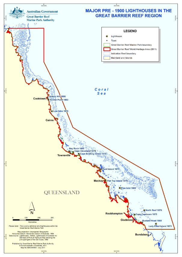
Figure 1. Major pre-1900 lighthouses in the Great Barrier Reef Region
Minister through the then Department of the Environment, Water, Heritage and the Arts (DEWHA) and in that process the Minister’s delegate sought advice from the Australian Heritage Council.
The present version of the plan was prepared with the assistance of Peter Marquis-Kyle, conservation architect.
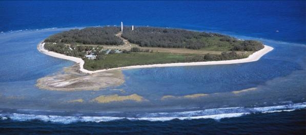
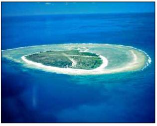
Aerial view of Lady Elliot Island (Source: GBRMPA)
The objectives of this Heritage Management Plan are to:
- Protect, conserve and manage the Commonwealth Heritage values of the Lady Elliot Island lightstation;
- Interpret and promote the Commonwealth Heritage values of the Lady Elliot Island lightstation;
- Manage use and where there is no adverse impact on the heritage values of the place, manage adaptive reuse of the lightstation consistent with the heritage values;
- Involve the community and stakeholders in the conservation management process in accordance with best conservation practice and statutory obligations; and
- Use best practice standards and apply best available knowledge and expertise when considering actions likely to have a significant impact on Commonwealth Heritage values.
In undertaking these objectives the Heritage Management Plan also aims to:
- Provide for the protection and conservation of the heritage values of the place while minimising any impacts on the natural environment by applying the relevant environmental management requirements in a manner consistent with all heritage conservation activities;
- Take into account the significance of the island as an abandoned guano-mining site;
- Encourage site uses that are compatible with the historical fabric, infrastructure and general environment; and
- Record and document maintenance, actions, interventions and reversible change in the GBRMPA Heritage Register.
The key performance indicators for the Heritage Management Plan are:
- The preservation of the Commonwealth Heritage values of the lightstation for current and future generations;
- Meeting the Implementation and Maintenance Plan requirements relevant to the lightstation consistent with lease requirements;
- Development and implementation of an interpretation plan, and ensuring appropriate interpretation materials on the Commonwealth Heritage values of the lightstation are available to visitors to Lady Elliot Island; and
- The publication of the Heritage Management Plan on the GBRMPA external website.
Since Governor Lachlan Macquarie ordered the building of a lighthouse at South Head near the entrance to Port Jackson in 1816 (and was criticised by his superiors in London for the cost), providing navigation aids has been the business of Australian Government agencies. It was a costly undertaking to build and operate lighthouses, but lighthouses reduced the risk of shipwreck and the cost was worthwhile. Up to the present time the cost has largely been paid by the operators of ships, through various schemes of dues, levies and charges.
Each of the colonies developed its own particular types and systems of lighthouse operation, reflecting the volume of shipping, the value of trade, the local building materials and the local navigation hazards. The earliest lighthouses were built in New South Wales and then Van Diemen’s Land (Tasmania), Victoria, South Australia and Western Australia followed.
When the colony of Queensland separated from New South Wales in 1859 there was only one lighthouse in the new territory – Cape Moreton lighthouse, a stone tower completed in 1857. The new colony, with no railways and only a few poor tracks, depended on coastal shipping, despite the difficulties of navigating a coast set behind the Great Barrier Reef. From separation in 1859 until federation in 1901 the Queensland marine authorities built an impressive set of lighthouses, which demonstrate remarkable frugality and technical innovation. The type of timber-framed, iron-sheeted lighthouse tower – of which the 1873 Lady Elliot Island lighthouse is the prototype – is a local Queensland invention. It turned out to be a remarkable technical and economic success, though the idea was not taken up elsewhere.
When the Australian colonies federated in 1901, they decided that coastal lighthouses would be a responsibility of the new Commonwealth. This new arrangement came into effect after the necessary legislation was passed in 1912, a survey of existing lighthouses was conducted by Commander C.R.W. Brewis RN, and a bureaucracy was established. The first of the state lighthouses was transferred to the new Commonwealth Lighthouse Service (CLS) in 1915. The CLS headquarters was in Melbourne, and designs became more standardised around the country, though regional depots (including one in Brisbane which was responsible for the coast between Torres Strait and Cape Moreton) still maintained some local character.
The Australian Maritime Safety Authority (the AMSA) is now responsible for operating Commonwealth lighthouses.
One of the first appointments made by the Queensland colonial government was a marine surveyor, Captain George Poynter Heath. Between his appointment in 1859 and his retirement in 1887 Heath was "responsible for supervising the opening of 13 new ports, establishing 33 lighthouses, 6 lightships and 150 small lights and marking 450 miles (724 km) of the inner route through the Barrier Reef" (Gibbney 1972). Captain Heath advised a parliamentary select committee that set out the beginnings of the policy for developing lighthouses along the Queensland coast.
In 1864 the select committee recommended erecting lighthouses at Sandy Cape and Bustard Head. Selection of these two sites reflects the importance at that time of the ports of Maryborough and Rockhampton. The government acted, and its agents in England procured two complete lighthouses in ‘kit’ form, with towers of cast iron segments which were bolted together on their sites. The two towers were manufactured by different foundries in England, though their designs were similar. Both were equipped with lantern houses and optical apparatus manufactured by Chance Brothers & Company, the major English lighthouse equipment maker. The Bustard Head lighthouse was first lit in 1868, and Sandy Cape in 1870. These fully imported cast iron lighthouses were effective, though costly.
Having pressed for the Sandy Cape and Bustard Head lights, the select committee members added that they did "not ignore the fact which this enquiry has impressed upon them, that there is before the Government of Queensland the much larger and more serious task of so lighting what is called the Inner Passage within the Barrier Reef, that not only the trade to our own rapidly increasing ports may be protected, but that much of the trade with India, China, and other countries to the North of this Continent may be diverted from the Western to the Eastern line of Passage" (Qld. Select Committee on the Rivers and Harbors of the Colony 1864). With the opening of the Suez Canal in 1869 the shipping route along the Queensland coast would become more important.
Concerning the next steps in development, the select committee considered that "Lady Elliott’s Island and Double Island are places where it will be desirable to erect Lighthouses, in addition to those already reported upon; but the still limited trade on the coast and the extent of those works which are of a more pressing nature, will prevent any action towards their erection at an early date". Lady Elliot Island, a coral cay at the southern end of the Great Barrier Reef, was to be the next site for a permanent Queensland lighthouse in 1873.
Lady Elliot Island was first occupied and used by Europeans in the early 1860s when extraction of deposits of guano began. Guano is an accumulation of seabird excrement, which was at that time a valuable fertiliser and gunpowder ingredient. J. Askunas, a guano merchant from Melbourne (Askunas & Co. 1861), claimed to have discovered the deposit and applied in 1861 for a lease. In 1863 he wrote to the Minister of Lands and Works offering £100 per year for five years for the exclusive right to mine guano on the island. The government responded by calling tenders for a three-year lease. Four tenders were received, including one from Askunas for £300 per year, which the government accepted. Askunas transferred the lease to Dr W.L. Crowther of Hobart in 1864, but apparently stayed on as an employee. The lease was extended and mining continued until 1873 (Thorburn 1967).
A temporary navigation light was erected at Lady Elliot Island in 1866, in the form of a tall mast on which a light was shown. Installation of this light may have been made possible, and desirable, because there were competent people living on the island to oversee the guano mining. This temporary light had shortcomings, and a severe storm gave Captain Heath a chance to remind the government that a proper lighthouse was needed:
"At Lady Elliott’s Island, during a very heavy gale in the early part of the year, several of the buildings belonging to the Guano Company were blown down, and the upper part of the flagstaff from which the temporary light was exhibited was carried away, so that the light, when exhibited at its reduced height, could not be seen, in every direction, clear of the tops of the trees. It was some time before I heard of this, and could send the Maryborough pilot vessel with a shipwright to fit and send up a fresh topmast, and properly secure the flagstaff. This shows that the permanent light now being prepared for this position is urgently required, especially as the difficulty of communication and consequent delay much increase the danger that may arise from any accident" (Thorburn 1967).
Heath’s reminder filtered through the bureaucracy, and at the end of May 1872 the architect F.D.G. Stanley, Superintendent of Public Buildings, was asked whether the plans were ready. Stanley’s office had been working on the design, for which credit is due to Robert Ferguson (1840-1906), at that time a District Foreman of Works. Ferguson already had some lighthouse experience; he wrote the specifications and oversaw the erection of the iron lighthouses at Bustard Head and Sandy Cape, and was probably responsible for a pair of timber lighthouse towers built on Woody Island, east of Fraser Island, in 1866 (DERM 2001). Ferguson was a skilled, innovative and practical architect (Watson and McKay 1994).
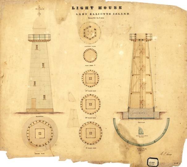
Figure 2. Contract drawing of Lady Elliot Island lighthouse, signed in 1872 (National Australian Archives: J2775, HS152)
For Lady Elliot Island, Robert Ferguson developed a new composite form of construction, which combined the economy of timber framing with the weather-tightness and durability of iron plating (Figure 2). After two rounds of tendering, Stanley reported to the government on the process and pitched the benefits of the new design:
"On connection with the Tower, as to construction and material, I would beg to remark that while the present design is more costly than the original, which was similar to those erected on Woody Island and entirely of timber, it is submitted that the increased strength and durability gained by using boiler plate casing, concrete foundation etc. will eventually more than compensate for the greater outlay in the first instance, the shrinkage and decay of timber sheeting in exposed situations such as the Lighthouse will occupy, being so great, as to render it almost impossible to keep the buildings weatherproof. Added to this the destruction caused by the white ant to all timbers placed below or upon the ground, is such as to render it most desirable, that every means should be used to place timber framing as far as possible beyond their reach" (Thorburn 1967).
The building contractors John and Jacob Rooney of Maryborough, who had already erected the lighthouse at Sandy Cape, were the successful tenders.
The lighthouse tower was round in plan and tapered in profile, forming a truncated cone. The tapering outer walls were framed with sawn hardwood posts and rails, bolted together with joints reinforced with wrought iron straps and brackets. The walls were lightly braced by timber braces which would have served to stabilise the timber structure before the iron shell was fitted. There were three intermediate floors with hardwood joists and pine floorboards. In the centre of the tower was a vertical timber weight tube, which formed a central support for a winding timber stair that ran up the bottom three levels of the tower. On the fourth level, where the conical tower was too small to fit a stair, there was a fixed ladder up to the level of the light room and balcony.
The frame was supported at the bottom by a segmented cast iron ring that formed a base, bolted to a massive concrete footing and floor cast within a low stone wall. The timber posts were bolted to lugs made as part of the iron base ring.
The tower was clad with a covering of wrought iron plates, about 2.5 mm thick, which were rolled to conform to the conical shape. The plates were lapped and riveted, and screwed to the timber framework and to the iron ring at the base. A timber door was fitted at the bottom of the tower, and glazed windows at each floor level.
At the top of the tower was a timber-framed structure, which formed the floor of the lantern room, and the projecting balcony that surrounded the lantern room. This balcony floor probably had a flooring of timber boards with a waterproof covering of lead sheet.
The lantern (the structure which enclosed the lantern room, and which protected the optical apparatus) had three main parts, as follows. The base (sometimes called the murette) was hexagonal in plan, framed in timber, clad with iron on the outside and with timber boarding inside, and capped with a timber sill. There was a low door in the base through which the keeper could crawl out onto the balcony. Above the base was the glazed section, also hexagonal in plan, with glass panes in a slender framework of iron. On top was the lantern roof (sometimes called a dome or cupola) of metal sheeting on an iron frame, with six facets curved to form a dome. At the peak of the roof was a weatherproof vent for the lamp smoke to escape. All of the parts just described were locally made in Queensland.
Inside the lantern room was mounted the optical apparatus, manufactured by Chance Brothers & Company, lighthouse engineers, in their factory at Smethwick near Birmingham, UK. The apparatus consisted of a rotating lens assembly of 250 mm focal radius which concentrated the light from a kerosene wick burner into several rays of light. As the lens assembly was slowly rotated by a clockwork (powered by a weight descending in the weight tube) the rays of light travelled around the horizon, showing an intense flash of light every 30 seconds to a navigator on a ship.
The Rooney Brothers’ contract included the construction of a single light keeper’s house near the lighthouse (Figure 3). This was an unusual provision. The usual staff of a lightstation was two or three light keepers, each of whom was provided with separate quarters. At Lady Elliot Island the guano company’s foreman on the island had worked as an occasional light keeper, so only a single official light keeper was needed. The guano company withdrew the foreman without notice, so a second keeper had to be appointed. A second cottage was built to accommodate him and his family.
In 1894 another operator began extracting guano from Lady Elliot Island (Brisbane Courier 1898). The Portmaster, Captain Almond, reporting on a tour of inspection of lighthouses after heavy storms in early 1895, described the situation at Lady Elliot: "No damage was found to have been sustained by any of the lights on the island, but the outer end of the Guano Company’s jetty, which was a light temporary structure, had been washed away. The Guano Company has erected ten or eleven buildings on the island, which gives it quite an important appearance" (Brisbane Courier 1895).
A newspaper article described the process used to extract the guano at Lady Elliot Island: after it is dug up, "the guano is put through sieves and dried, when it is conveyed by trolleys drawn by a small locomotive to the store sheds. Here it is analysed, the material failing to pass the prescribed test being condemned. As the island is by no means sheltered the loading of vessels was in times of bad weather a tedious if not impossible task. To escape the surf which breaks all around the island the company erected a long jetty on the lee side. Owing to the small depth of water, however, large vessels had to lie at anchor some half-mile from the shore, the guano being lightered to them in small five-ton punts. It is believed that in all about 20,000 tons of guano have been shipped from the Lady Elliot Island" (Brisbane Courier 1898).
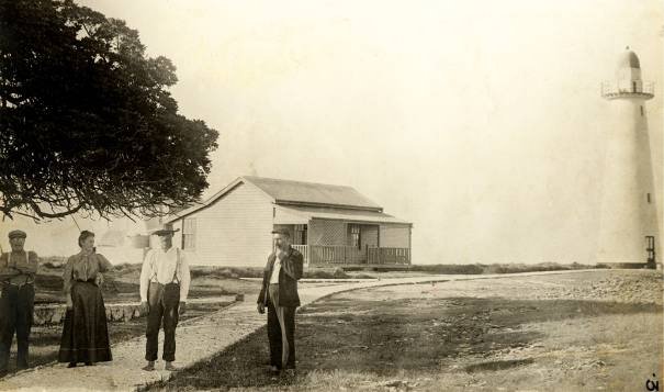
Figure 3. Lady Elliot Island lighthouse and cottage, undated (Source: Australian Maritime Safety Authority)
The lighthouse was operated by the Queensland Department of Harbours and Rivers until the Commonwealth Lighthouse Service was established. In preparation for the handover of responsibility, the Commonwealth commissioned a detailed survey of Australian lightstations from Commander C.R.W. Brewis, a retired British naval surveyor: "Brewis’s careful examination by sea of each coast gave the Commonwealth the basis for a strategy, which it began to implement even before it formally took control of all coastal lights in 1915" (Reid 1988). In his 1912 report on the Queensland coast, Brewis recorded that the Lady Elliot Island lighthouse tower, apparatus and dwellings were in good order, with two light keepers at the station. The fourth order apparatus showed a white light of 4,000 candlepower, flashing every 30 seconds. He recommended upgrading the brightness of the light to 15,000 candlepower by installing a 55 mm incandescent mantle vaporised kerosene lamp. He also recommended equipping the station with an acetylene Morse signalling lamp, for better communication with ships (Brewis 1912).
The brightness of the light was upgraded to 23,000 candlepower in 1923 (Reid 1988), probably by installing a pressurised kerosene system with incandescent mantle lamp in the original rotating lens assembly as Brewis had recommended.
In 1927 a major overhaul of the station began. At the lighthouse itself, the optical apparatus, the lantern, and the balcony/lantern-room floor were all replaced. Three new houses were built, to replace the two old ones.
The new optical apparatus supplied by Chance Brothers & Company included a mercury pedestal (Chance Bros. & Co. Ltd n.d.a) – a form of low-friction bearing first used in Australia in 1896 at Cape Leeuwin – which required less maintenance than earlier types. There was a new fourth order (250 mm focal radius) catadioptric lens assembly, with three single-flashing faces (Chance Bros. & Co. Ltd n.d.b). The light output, from an incandescent kerosene burner, was rated at 85,000 candlepower (Reid 1988).
The 1873 lantern was removed, and replaced by the present Chance Brothers & Company lantern with curved glazing, vertical astragals, and a drum type (Admiralty pattern) roof vent (Chance Bros. & Co. Ltd n.d.c). The 1873 balcony floor structure was removed, and replaced by the present assembly of mild steel plate floor supported on rolled steel channel beams. The present steel balcony balustrade was also installed.
The three new detached houses were typical of those being built at other lightstations on the Queensland coast – single-storey timber houses with surrounding verandahs, low set on concrete piers (Figure 4).
The keepers and their families received fresh food and other supplies by boat from Bundaberg each fortnight (AMSA 1962). They used rainwater for drinking and washing, and kept chickens and goats for fresh eggs and milk. Their lives were made a little more comfortable when a diesel generator was installed to provide power to the houses. New spherical glass reinforced plastic rainwater tanks were installed in 1963 to supplement earlier corrugated iron tanks. In 1966 the bathrooms were equipped with toilet pans connected to septic tanks.
A report of a visit by an engineer of the lighthouse tender in 1961 mentions that all of the goats on the island had been killed, and that the Head Keeper was "…going in for a beautification scheme now that goats are gone" (AMSA 1962). Photographs from around this time show small casuarina trees newly planted around the houses. Subsequent photographs chart the growth of these trees.
A new brick generator shed with two diesel generator sets was built in 1975, and the equipment removed from the earlier timber-framed generator shed so it could be used for other purposes.
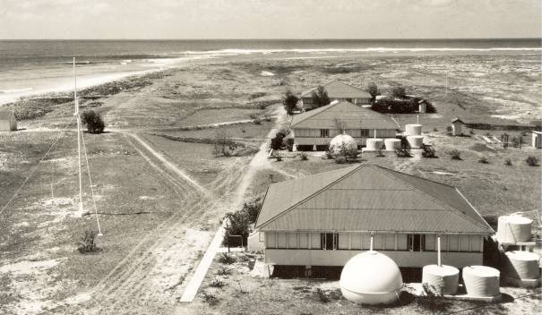
Figure 4. Lady Elliot Island cottages, undated (Source: Australian Maritime Safety Authority)
In 1969 businessman Don Adams agreed with the Commonwealth Department of Transport to build an airstrip on Lady Elliot Island in return for a lease of a portion of it for tourist recreation purposes. His company built the airstrip, established tourist accommodation, and began work to revegetate the island with pandanus, casuarinas, other native flora and coconuts (Walsh 2006). Development of the resort has continued under other operators.
In 1980 the lighthouse was converted from kerosene to acetylene operation. This involved extensive changes to the optical apparatus, in which only the 1927 Chance Brothers & Company lens assembly was retained. The mercury pedestal and clock were removed and replaced with an AGA Dalen rotating pedestal type PRDA-120. The PRDA-120 used the flow of gas to rotate the lens very slowly during the day so that the sun would not be focused by the lens and start a fire, and after dark at the right speed for the apparatus to show the correct character. A Dalen sun valve sensed the onset of darkness and lit the incandescent burner which burned constantly through the night. At sunrise the gas flow was automatically cut off by the sun valve, except for a small pilot flame. A man-proof fence was built around the tower and former generator shed.
Thus converted, the lighthouse could operate automatically without human intervention. Only periodic service visits were required to replace gas bottles and to check the equipment. The keepers were withdrawn from Lady Elliot Island after staff of the resort had been trained to record and report weather observations.
The acetylene conversion was successful, but by the late 1980s the casuarina trees on the island had grown so tall that they obstructed visibility of the light from some sectors. Also, the department was beginning to phase out the use of acetylene for navigation lights (Reid 1988). In 1989, as a temporary measure, a weatherproof Pintsch-Bamag electric rotating beacon was installed on a platform above the old lantern roof. This beacon was powered by batteries that were charged by solar photovoltaic panels fitted on the roof of the generator shed.
In 1995 the old lighthouse was superseded by a new taller structure a short distance away (Figure 5 and Appendix 1, Figure 9). This is a modern steel lattice tower of the current standard design, equipped with a GRP battery house, solar panels, racon, and Vega VRB-25 beacon. This white painted tower is surrounded by a man-proof fence.
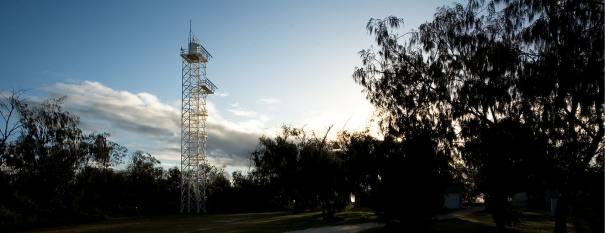
Figure 5. AMSA navigation tower, Lady Elliot Island (Image: Peter Marquis-Kyle)
Lady Elliot Island is situated at the southernmost end of the Great Barrier Reef approximately 90 kilometres north-east of Bundaberg and 150 kilometres east-south-east of Gladstone (24° 07' S, 152° 43' E) (Figure 1). The island, which occupies a surveyed area of 34.67 hectares, is Australia’s most southerly coral cay and is situated at the southerly end of a drying platform reef of about 142 hectares. While it is now regarded as separate from the Capricorn-Bunker Group of cays and reefs, which straddle the Tropic of Capricorn immediately to the north, Lady Elliot is part of that distinctive geomorphic province characterised by mostly medium-sized reefs in late stages of growth.
 The reefs and associated cays of the province lie on the western marginal shelf and rise from a ridge at about 60 metres deep, which broadens into submerged shoals, emergent reefs and coral cays extending through the southern region of the Great Barrier Reef. All the cays are very recent, forming since the sea reached its present level about 6000 years ago and becoming stable vegetated ecosystems much more recently. The 15 cays that comprise the province vary widely in size and in composition. The largest is North West Island with an area of about 105 hectares and the smallest is North Reef Cay, which is only 1.0 hectare in area. Lady Elliot Island is the third largest of the cays (approximately 35 hectares) behind Masthead Island (40 hectares).
Apart from size, the most significant differences in the ecology of the cays in the province are determined by the substrate, which itself is an expression of the geomorphic processes that formed them. Like the cays of the southern Bunker Group, Lady Elliot Island is a relatively large cay on a small reef. In contrast with the northerly cays of the Capricorn Group such as Heron Island, Masthead Island and North West Island, which are sand cays resulting from relatively low energy tidal deposition, the Bunker cays and Lady Elliot Island are the consequence of storm-deposited shingle berms.
Lady Elliot Island is located close to the windward side of the reef edge. The major berms on the island are laid approximately perpendicular to the line of prevailing storm winds, although there is some tendency for the ends of the berms to curl.
Shingle cays such as Lady Elliot Island therefore have few areas in which deep sandy soils can form. On Lady Elliot Island, deeper soils have formed on the south-west corner in the vicinity of the lighthouse and in the middle of the existing resort area. In the south-west, the deeper sands represent a lower energy tidal deposition of finer sediments in the lee of the reef. Within the resort, the area of deeper sands represents a lower energy deposition site that would have been active in the lee of some of the bigger berms in the early stages of cay formation. The ridges of the berms themselves remain, as can also be seen on Lady Musgrave Island, as slabs of shingle, poorly vegetated with succulent herbs, small shrubs, and the occasional stunted sandpaper fig (Ficus opposita). Taller woody vegetation, notably the characteristic Pisonia grandis, occupies the swales between the berms.
Lady Elliot Island is one of the most important sites in the Great Barrier Reef World Heritage Area for seabird nesting. Seabird diversity is the highest of any island on the Great Barrier Reef. The island is home to a number of threatened bird species; it is one of only two breeding sites on the Great Barrier Reef for the red-tailed tropicbird (Phaethon rubricauda), and an important site for nesting roseate terns (Sterna dougallii). As well as an important breeding site for these birds and other seabirds such as the black-naped terns (Sterna sumatrana), bridled tern (Onychoprion anaethetus), crested tern (Thalasseus bergii), wedge-tailed shearwater (Ardenna pacifica), black noddy (Anous minutus) and common noddy (Anous stolidus), it is a roosting site for the lesser frigatebird (Fregata ariel), great frigatebird (Fregata minor), and brown booby (Sula leucogaster). It is also a site for migratory birds covered under international migratory bird treaties such as Pacific golden plover (Pluvialis fulva), bar-tailed godwit (Limosa lapponica), and grey-tailed tattler (Tringa brevipes). The Capricorn silvereye (Zosterops lateralis chlorocephalus) is confined to the southernmost Great Barrier Reef, and there is a resident breeding population on Lady Elliot Island. The island's location as the southernmost island on the Great Barrier Reef provides an important site for seabirds to access food in the waters of the southern Great Barrier Reef and beyond.
After thousands of years of seabird nesting, the island was recognised as a rich source of guano in 1863 by J. Askunas. Large-scale guano mining was undertaken on the island in the 1860s and 1870s, and again in the 1890s. Foraging by feral goats prevented recovery of the native vegetation until revegetation work was initiated in the 1960s by the light keepers and by the resort founder Don Adams.
The island is also a nesting site for green turtles (Chelonia mydas) and loggerhead turtles (Caretta caretta). The turtles that use Lady Elliot Island are an important component of the turtle populations of the southern Great Barrier Reef.
The Heritage Management Plan Area occupies approximately 0.8 hectares along the western side of the island (Appendix 1, Figures 9 and 10) and is delineated by the boundary of the lighthouse and residential precincts (Appendix 1, Figure 11). In addition to the Heritage Management Plan Area, the area west of the airstrip is defined as an area sensitive to the heritage values of the lightstation setting (Appendix 1, Figure 10).
The lighthouse precinct contains the lighthouse and a cluster of associated service buildings, including a workhouse, power house, the old power house and a fuel store and drum platform (Appendix 1, Figure 11). The lighthouse is no longer used as a navigational aid as a separate facility has been built.
The residential precinct, which sits adjacent to the lighthouse precinct, contains three houses, a boat shed, water tanks, clothes hoists and a concrete loading dock (Appendix 1, Figure 11).
Lot 1 of 65 m2 is leased to the AMSA for its current navigation aids (Appendix 1, Figure 9). The AMSA leased area is fenced and is entered only by AMSA staff and authorised contractors.
Lot 2 (the airstrip) and Lot 3 (the balance) are leased to a private lessee for purposes of tourism and education (Appendix 1, Figure 9). The buildings of the lightstation precinct are used and maintained by the lessee, the company that operates the tourist resort on the island. The three former keepers’ houses are occupied by staff of the resort, and the other buildings (except for the lighthouse) are used for storage or other purposes.
The natural landscape of Lady Elliot Island has been irrevocably altered by guano mining followed by subsequent decades of intensive cropping by goats.
Today the biological environment of Lady Elliot Island is far from natural, and contains the largest number of exotic plant species on any cay in the region (Laurence et al. 1995). This is largely due to the proliferation of exotic species of garden plants introduced by the families of the lighthouse keepers, including woody lantana (Lantana camara); mother of millions (Kalanchoe tubiflora), mother-in-law’s tongue (Sansevieria trifasciata), live leaf (Bryophyllum pinnatum), cobbler’s pegs (Bidens pilosa) and Mossman River grass (Cenchrus echinatus). The Australian native tree species Casuarina equisetifolia, which was introduced, is also prolific today providing habitat for nesting seabirds.
Lady Elliot Island lightstation is listed on the Commonwealth Heritage List. The official statement of the place's Commonwealth Heritage List values is recorded on the Australian Heritage Database at http://www.environment.gov.au/cgi-bin/ahdb/search.pl. Below is a fresh assessment of significance, using the Commonwealth Heritage List criteria, and taking account of new and better information.
Lady Elliot Island lightstation, established in 1866, is significant for its evidence of important steps in the development of a system of navigation aids along the Queensland coast in the nineteenth century. The centrepiece is a lighthouse, first lit in 1873, that was the first of a series designed in Queensland to suit local conditions and economic constraints. The lighthouse and its associated buildings, most dating from the early twentieth century, demonstrate the way such lightstations were developed in response to changes in social expectations and technological capabilities (criterion a).
The 1873 lighthouse is significant as the prototype timber-framed and iron-plated tower, and demonstrates a high level of technical achievement at that time (criteria b and f).
The lightstation is important as a characteristic example of the type of lighthouse complex developed along the Queensland coast and on the Great Barrier Reef islands in the late nineteenth century, and maintained through the twentieth century (criterion d).
Lady Elliot Island lightstation has valuable aesthetic characteristics (criterion e).
The 1873 lighthouse tower exemplifies in an important way the role of architects Robert Ferguson and F.D.G. Stanley (criterion h).
Lady Elliot Island lightstation, established as a permanent aid to navigation in 1873, is important in illustrating the development of coastal navigation in Australia and the evolution of lighthouse design and technology since the time when each of the Australian colonies was responsible for the design of navigation aids in its waters. The lighthouse is the first of a series of 12 lighthouse towers built with a timber frame covered with curved riveted wrought iron plating, a mode of construction developed in the Queensland Public Works Department in response to the need for economical and durable structures. The station demonstrates the way of life of the light keepers and their families, and the historical pattern of episodic change in the technology and practice of lighthouse operation at an established lightstation from the 1870s to the 1990s.
Attributes: The lighthouse, the keepers’ quarters, the ancillary buildings, the grave yard, the spatial arrangement of the structures, and the culturally modified landscape.
The lighthouse tower, built in 1873, is exceptionally important, as the prototype timber-framed iron-plated lighthouse, in demonstrating development of a structural system local to Queensland.
Attributes: The original fabric of the tower, including the concrete and stone base; the cast iron base ring; the hardwood posts, rails and braces; the timber intermediate floors; the central timber weight tube and winding stairs; the riveted iron plating.
The assemblage of buildings and other structures arranged on the island landscape is important in demonstrating the characteristic arrangement of a fully staffed remote island lightstation. Typically, it shows the physical evidence of the provision for keepers who tended the rotating kerosene light in watches through the night, kept records, observed and signalled ships, maintained the station equipment and buildings, and lived a civilised life with their wives and children in a remote place.
Attributes: The lighthouse, the three keepers’ houses, all the ancillary buildings and structures, the coral paths, and the culturally modified landscape.
The lighthouse is a prominent feature and focal point of this low island. It has a high level of aesthetic appeal because of its pure geometric form and white and red colour scheme which contrast strongly with the vivid blues and greens of its setting. The keepers’ houses have aesthetic value arising from their uniformity and their surroundings of coral paths, shady trees and green grass.
The lighthouse is also recognised for its landmark qualities.
Attributes: The lighthouse, including its colour scheme; the form and landscape setting of the keepers’ houses; the visibility of the lighthouse from the sea marking the southernmost end of the Great Barrier Reef Marine Park.
The lighthouse tower is significant as the first example of a timber-framed iron-plated lighthouse, a local Queensland invention that was to become the characteristic type of lighthouse in Queensland until the Commonwealth takeover in 1915.
Attributes: The original fabric of the tower, including the concrete and stone base; the cast iron base ring; the hardwood posts, rails and braces; the timber intermediate floors; the central timber weight tube and winding stairs; the riveted iron plating.
The lighthouse is significant for its association with the architects responsible for its design and construction: Foreman of Works Robert Ferguson and Colonial Architect F.D.G. Stanley.
Attributes: The 1873 lighthouse tower.
The foregoing assessment of significance is based on a fresh study of historical documents and inspection of the fabric of Lady Elliot Island and other comparable lightstations. It corrects several errors in previous descriptions and significance assessments of Lady Elliot Island lighthouse – errors which were carried over to the citation in the Commonwealth Heritage List among other documents. The errors concern the metal plating and timber stairs of the tower.
The metal plating has erroneously been described as cast iron. The metal plating at Lady Elliot Island is wrought iron plate, measuring about 2.5 mm thick (12 gauge). Plate of various thicknesses was used on the lighthouses of the series – ranging from less than 2 mm thick (perhaps 14 gauge) at Low Isles (1878) up to about 3.2 mm (10 gauge) at North Reef. Wrought iron plate is a distinctly different material from the cast iron used for the earlier towers at Bustard Head (first lit in 1868) and Sandy Cape (1870) with tower walls about 30 mm thick – wrought iron can be hot-rolled into thin sheets, is ductile and malleable, and has a high tensile strength. It was also available galvanised – that is, coated with zinc to inhibit corrosion. The wrought iron plate was manufactured in England and shipped to Australia as flat sheets. The building contractors cut each plate to the correct outline and curved it to fit the conical shape of the tower. This extract from the contract specification for North Reef lighthouse (1878) explains how the plating was arranged:
"The iron for shell of tower is of No 10 gauge, (charcoal) galvanised, and will be supplied by the Government. The Contractor will take delivery of same at the Port Office Brisbane. The Contractor will provide the following tools for working the above iron to the curvature and batter of tower viz.
- One Roller machine sufficiently powerful to set all dents out of iron to be tested in Brisbane.
- Also one pair of shears sufficiently powerful to cut all sheets accurate and clean on all edges, to the curvature and batter.
- Also one punching machine for rivet holes.
The Contractor shall provide gald rivets for tower ½" in length by ¼" in diameter having snap heads also gald wood screws to be used around all openings and where the joints of sheets cross the timbers. These screws will be specially ordered 1"x¼" snap headed, similar to rivets for hardwood, and for the beech linings they will be 1½".
The bottom course of shell plates will be fitted closely to rib of base plate and secured thereto by 3/8 snap headed bolts screwed up on the inside.
All other joints, horizontal and vertical, shall be rivetted with rivets before specified 1½" centre to centre, the ends of rivets on the inside being neatly formed with a snap tool.
The lap of all plates shall be 2" and a film of stiff red lead shall be used in each joint as the rivetting is done.
The surplus iron on the lap of each sheet shall be cut off so that the joint may be neat and close on the inside.
Care will be taken that the rivet holes are not marked too close to the timbers, so that rivetting can be done in a workmanlike manner also that the holes for woodscrews do not come within ½" of the edge of timbers. At these particular places the holes may be spaced 2" apart if required" (Qld State Archives: Public Works Dept. 1877).
As to the winding timber stairway in the tower, which the heritage list describes as rare, is actually similar to those in most of the 12 timber-framed iron-plated lighthouses built in Queensland in the nineteenth century. The winding timber stairway may however still retain rarity value when considered comparatively at the national level. Of the 12 built, the following eight survive and all have similar winding timber stairs: Lady Elliot Island (1873), Cape Bowling Green (1874) [moved to the Australian National Maritime Museum in Sydney], Low Isles (1878), North Reef (1878), Dent Island (1879), Double Island Point (1884), Pine Islet (1885) [moved to Mackay Harbour] and Booby Island (1890). The other four were short towers built with fixed ladders instead of stairs: Cape Capricorn (1875) [demolished], Flat Top Island (1879), Cape Cleveland (1879) and Archer Point (1883) [demolished].
All elements of the lightstation are located on the western side of the island (refer to Appendix 1, Figures 9 and 10, with the numbers below identifying buildings shown on Figure 11).
The lighthouse precinct contains:
- Building 1 – Lighthouse
- Building 6 – Power house
- Building 7 – Workshop
- Building 8 – Old power house
- Building 9 – Fuel store and oil drum platform.
The lighthouse is no longer used as a navigational aid as a separate facility has been built.
The residential precinct lies to the north of the lighthouse precinct and includes:
- Building 2 – House 1
- Building 3 – House 2
- Building 4 – House 3
- Building 5 – Boat shed
- Water tanks
- Clothes hoist
- Concrete loading dock.
Three fowl yards (two since demolished), a well and two graves, marked with headstones and surrounded by a picket fence, are outside these two precincts (Appendix 1, Figures 11 and 12).
Element | History | Description and condition | Fabric significance rating |
Lighthouse tower [Part of Building 1 – Appendix 1, Figure 11] 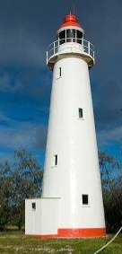
| 1878: Partly pre-fabricated at Maryborough by contractors J & J Rooney and erected on site. c. 1928: Original hexagonal lantern, timber balcony, balcony rail, replaced. c. 1930s: Enclosed porch added. c. 1975: Lower section of bottom course of plating replaced with stainless steel. 1995: Tower taken out of service; all optical apparatus removed. 2007: Stainless steel plating removed, replaced with galvanised steel; entire tower exterior painted. | Concrete base contained within stone wall; timber tower frame, floors, stairs, ladder; curved iron plating with fixed glass windows and timber-framed and sheeted door. Nothing remains of the original balcony floor, lantern, or optical apparatus. Condition: Stable; painted externally in 2007. | Exceptionally significant as the first timber-framed iron-plated lighthouse (criterion b), and for its evidence of the development of lighthouse technology (criteria a and f). Highly significant for its association with its designers (criterion h), its characteristic values (criterion d), and its aesthetic value (criterion e). |
Lighthouse balcony and lantern room floor [Part of Building 1 – Appendix 1, Figure 11] 
| c. 1928: Steel fabricated floor and handrail installed, replacing earlier timber structure. 2007: Balcony painted with rest of tower. 2011: Balcony partially repainted. | Steel plate floor, round in plan, bolted onto rolled steel angle and channel supports, with steel balcony handrail. Condition: Additional painting of balcony required to arrest rust; otherwise stable. | Highly significant for its evidence of the development of the lightstation (criterion a). |
Lighthouse lantern room [Part of Building 1 – Appendix 1, Figure 11] 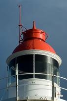
| | Chance Brothers & Company fourth order lantern with vertical astragals, curved glazing, drum (Admiralty pattern) vent. Condition: Stable. | Highly significant for its evidence of the development of the lightstation (criterion a), its characteristic values (criterion d), and its contribution to aesthetic value (criterion e). |
Lighthouse porch [Part of Building 1 – Appendix 1, Figure 11] 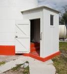
| | Enclosed porch with timber frame covered with flat asbestos-cement sheet; skillion roof; concrete floor at level of bottom stair tread; ledged and braced door; fixed glass window. Condition: Stable. | Highly significant for its evidence of the development and operation of the lightstation (criteria a and d), particularly the control of drafts to which the incandescent kerosene lamp was susceptible. |
New power house [Part of Building 6 – Appendix 1, Figure 11] 
| 1975: New brick building to house two diesel generator sets and batteries. 1980: Acetylene gas bottles, manifolds and other pipe work installed to replace diesel generators. 1989: Photovoltaic solar panels installed on roof, batteries and control gear inside, to replace gas equipment. 1995: Solar panels and batteries removed. | Freestanding building with concrete slab on ground; unpainted cavity brick walls; concrete ring beam; stainless steel sheeted skillion roof; bunded fuel storage area attached at back, enclosed with chain wire fence. Used for storage by resort operator. Condition: Stable; minor cracking to concrete ring beam. | Moderately significant for its evidence of the development and operation of the lightstation (criteria a and d), particularly the provision of household electricity for the keepers. |
Old power house [Part of Building 8 – Appendix 1, Figure 11] 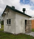
| c. 1930s: Built as generator shed. 1975: Superseded by new power house. | Small gable roofed building; timber frame; concrete slab on ground floor; walls sheeted with flat asbestos-cement; roof sheeted with corrugated asbestos-cement sheet. Used for storage by resort operator. Condition: Stable. | Moderately significant for its evidence of the development and operation of the lightstation (criteria a and d), particularly the provision of electricity for radio operation and the keepers’ domestic purposes. |
Workshop [Building 7 – Appendix 1, Figure 11] 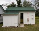
| c. 1930s (unconfirmed): Built as radio room. Later date (unconfirmed): Lean-to added for storage. Later date (unconfirmed): Adapted for workshop. | Small gable roofed building with skillion roofed extension; timber frame; concrete slab on ground floor; walls sheeted with flat asbestos-cement; roof sheeted with corrugated asbestos-cement sheet. Used for storage by resort operator. Condition: Stable. | Moderately significant for its evidence of the development and operation of the lightstation (criteria a and d), particularly the introduction of radio transceivers for communication of weather and shipping information. |
Fuel store [Building 9 – Appendix 1, Figure 11] 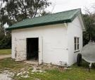
| c. 1930s: Built as fuel store. | Small gable roofed building; timber frame; concrete slab on ground floor; walls sheeted with flat asbestos-cement; roof sheeted with corrugated asbestos-cement sheet. Used for storage by resort operator. Condition: Stable. | Moderately significant for its evidence of the development and operation of the lightstation (criteria a and d) particularly the necessity to store diesel fuel for power generation and kerosene for lighthouse lighting. |
Fuel drum rack 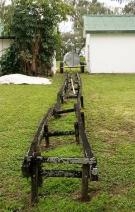
| c. 1930s: Built as storage rack for fuel drums. | Two parallel hardwood rails supported on short hardwood posts, designed to hold 44 gallon (200 litre) drums clear of the ground. Condition: Settled and misaligned; one rail not supported at one end. | Moderately significant for its evidence of the development and operation of the lightstation (criteria a and d), particularly the necessity to store diesel fuel for power generation and kerosene for lighthouse lighting. |
Light keepers’ houses [Building 2,3 and 4 – Appendix 1, Figure 11] 

| c. 1927: Houses built. 1966: Bathrooms altered, WC pans and septic tanks installed. c. 1980s: Lighthouse keepers withdrawn, houses occupied by resort staff. Modifications to the houses include additional internal walls to increase the number of bedrooms. c. 2000s: One house has had some internal walls removed to restore closer to original. 2011: Severe cracking in concrete piers repaired. | Three identical detached timber-framed single-storey lowset houses with surrounding verandahs. Houses are lined with flat asbestos-cement sheeting, and supported on concrete truncated pyramid piers. Each has three concrete stairs. The verandahs are enclosed with asbestos-cement sheeting, shutters and casement windows. The hipped roofs are sheeted with corrugated asbestos-cement. Condition: Stable. | Moderately significant for their evidence of the development and operation of the lightstation (criteria a and d), particularly in demonstrating the way of life of the keepers and their families. |
Rainwater tanks 
| 1963: New spherical glass reinforced plastic rainwater tanks installed. | Six spherical GRP tanks, each about 3.6 m diameter, partly sunk into the ground, two at each of the houses. Condition: Stable. | Moderately significant for their evidence of the development and operation of the lightstation (criteria a and d), particularly in demonstrating the need to collect and store rain water for use by the keepers and their families. |
Boat shed [Building 5 – Appendix 1, Figure 11] 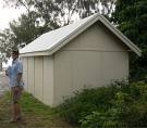
| c. 1930s: New boat shed built, to replace earlier structure on same site. 2000s: New COLORBOND® corrugated steel roof sheeting fitted, to replace corrugated asbestos-cement. 2007: Asbestos wall sheeting removed and replaced. | Small gable roofed building; timber frame; concrete slab on ground floor; walls sheeted with flat asbestos-cement; roof sheeted with corrugated steel. Condition: Stable. | Moderately significant for its evidence of the development and operation of the lightstation (criteria a and d), particularly in demonstrating the use of small boats by the keepers. |
Fowl house 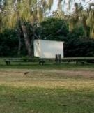
| c. 1930s: Fowl houses and enclosures provided for each of the keepers’ houses. post-1995: Two of the fowl houses removed. | One small skillion roofed building; timber frame; walls sheeted with flat asbestos-cement; roof sheeted with corrugated asbestos-cement. Condition: Roof deteriorated. | Moderately significant for its evidence of the development and operation of the lightstation (criteria a and d), particularly in demonstrating the keepers’ practice of keeping poultry for eggs and meat. |
Steel tank stands 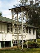
| post-1963: Tall pre-fabricated steel tank stands with corrugated steel tanks provided for each of the keepers’ houses, to replace earlier lower level tank stands. post-1963: Corrugated steel tanks removed. c. 2000s: One steel tank stand removed. | Two of the three tank stands remain, each with galvanised hot-rolled steel angle stanchions, rails and braces, with timber decking on channel joists; no tanks remaining; semi-rotary hand pumps and pipe work fixed to house. Condition: Stable. | Moderately significant for their evidence of the development and operation of the lightstation (criteria a and d), particularly in demonstrating the need to collect and store rain water for use by the keepers and their families. |
Septic tanks 
| 1966: Septic tanks, absorption trenches, and WCs installed at each of the keepers’ houses. 2011: Septic system pipe work replaced. | Three concrete septic tanks partly buried behind houses, with associated drains and fixtures. Condition: Stable. | Moderately significant for their evidence of the development and operation of the lightstation (criteria a and d), particularly in demonstrating the provision of contemporary facilities for the keepers and their families. |
Loading ramp 
| pre-1975: Loading ramp built. | Concrete retaining wall, backfilled with soil. Condition: Stable. | Moderately significant for its evidence of the development and operation of the lightstation (criteria a and d), particularly in demonstrating the handling of materials. |
Coral paths 
| pre-1928: Network of paths linking quarters, boat shed, flagstaff and lighthouse. post-1928: Paths adapted to fit location of the three new houses. | Raised pathways of coral, now overgrown with grass. Condition: Stable. | Moderately significant for their evidence of the development and operation of the lightstation (criteria a and d), particularly in demonstrating the functional relationship of the various building materials. |
Concrete paths 
| post-1928: Paths around keepers’ houses. | Concrete paths. Condition: Minor cracking; otherwise stable. | Moderately significant for their evidence of the development and operation of the lightstation (criteria a and d), particularly in demonstrating the pattern of use of the buildings. |
Introduced plants 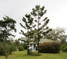
| 1961: Goats, which had roamed the island since the nineteenth century, were finally eradicated; keepers began planting trees, shrubs and garden plants. 1969: Resort operator began revegetation program. | A range of decorative and shade trees, shrubs and garden plants, not assessed or recorded in detail for this plan. Condition: Not assessed. | Moderately significant for their evidence of the development and operation of the lightstation (criteria a and d), particularly in demonstrating the efforts of the keepers to improve the amenity of the lightstation. |
Graves 
| 1896: Burial of P.J.M. Phillips. 1907: Burial of Susannah McKee. | Site of two graves, marked with headstones, surrounded by a picket fence. Condition: Some pickets loose; otherwise stable. | Moderately significant for their evidence of the development and operation of the lightstation (criteria a and d), particularly in demonstrating the isolation of the lightstation. |
The buildings and other structures of the lightstation are generally in good, stable condition, having been well built and generally well maintained. Detailed building audits were undertaken in 2005 (QBuild Wide Bay Regional Office 2005) and 2011 (SIMTARS 2011; QPWS 2011, unpublished data). These identified a number of repairs that were necessary to keep the buildings in sound condition. Repairs have been completed and continue to be undertaken in accordance with the recommendations.
Essential repairs have been made to the lighthouse tower, including external painting completed in late 2007 through funding provided by the GBRMPA (Figure 6). As part of that work a section of stainless steel sheeting fitted to the base of the tower, which had triggered rapid galvanic corrosion, was replaced with galvanised steel. The roof of the lighthouse tower porch was replaced with corrugated steel. Additional painting has been conducted on the lighthouse tower balcony in 2011 and is scheduled to continue in 2012.
Repairs have been completed on one of the three houses – paint finishes and bathroom fixtures have been refurbished. The other two houses are scheduled to receive similar treatment. Other major items of work completed include the repair of the characteristic pyramid-shaped concrete piers that were severely cracked, and upgrading of the septic waste drainage system. The work on the houses has been undertaken by the lessee who continues to undertake repairs in accordance with five year maintenance plans. All works are conducted to ensure the significance of the buildings is not diminished.

The Lady Elliot Island lightstation Commonwealth Heritage place is subject to a number of environmental management plans and legislative requirements. Taken together, these represent the management arrangements for this place. A summary of key arrangements under these plans is outlined below.
The Great Barrier Reef Heritage Strategy (GBRMPA 2005) states that the area will be managed in a way which is consistent with the Commonwealth Heritage management principles.
Early consultation with the Heritage Division in the Department of Sustainability, Environment, Water, Population and Communities (SEWPaC) in the planning stage of any proposals is also encouraged to obtain advice on the likely impacts on the heritage values of the place. The Great Barrier Reef Heritage Strategy also outlines a dispute resolution process to deal with works proposals that may adversely impact on heritage values.
Lady Elliot Island is subject to a number of other plans or management considerations. These are outlined below.
The Lady Elliot Island Lightstation Heritage Management Plan has been prepared in accordance with the requirements of the EPBC Act and the EPBC Regulations, the Great Barrier Reef Marine Park Act 1975 and the Great Barrier Reef Marine Park Regulations 1983. The heritage policies outlined in the Lady Elliot Island Lightstation Heritage Management Plan apply to the management of the Lady Elliot Island lightstation historic precincts.
The EPBC Act also includes referral provisions to manage significant impacts. An outline of these provisions and referral matters can be found on the SEWPaC website: http://www.environment.gov.au/epbc/approval.html
Under the Great Barrier Reef Marine Park Zoning Plan 2003, Lady Elliot Island is designated a Commonwealth Islands Zone and may be used or entered without permission for: low impact (non-extractive) activities including recreational activities; photography and filming; traditional use of marine resources; and limited educational programs. All other activities including camping and research require written permission. The waters surrounding Lady Elliot Island are designated a Marine National Park (Green) Zone. The Lady Elliot Island Lightstation Heritage Management Plan is consistent with the objectives of the Commonwealth Islands Zone to ensure minimal environmental impact.
Lady Elliot Island is a Commonwealth Island; therefore the Queensland Heritage Act 1992 does not apply. The place is not included in the Queensland Heritage Register. Other state legislation may apply to protect the natural values of the site, complementing the overarching Commonwealth legislative framework.
Lady Elliot Island is not currently entered on the National Trust of Queensland’s heritage register.
Heritage management considerations and principles have been incorporated within the GBRMPA’s administration of the Marine Park. The GBRMPA Board has included heritage matters within the GBRMPA Corporate Plan 2011-2014. In this regard, the GBRMPA adopted the following objectives to adhere to legislative, regulatory and reporting requirements, including heritage obligations.
The GBRMPA has several mechanisms in place to ensure appropriate implementation of heritage management plans. In addition to the Lady Elliot Island Lightstation Heritage Management Plan, conservation of heritage values are managed through:
- Commonwealth Islands zoning, permits and impact assessment requirements;
- Policies relating to the protection and values of Lady Elliot Island; and
- Lease requirements for the protection of heritage values.
Two lessees have lease arrangements with the GBRMPA for Lady Elliot Island. The lease agreements require the lessees to comply with the requirements set out in this Heritage Management Plan:
- The private lease relates to the use of the island for resort purposes (Figure 7) and commenced on 1 December 2005; and
- A second lease relates to the ongoing presence of a navigation light and commenced on 27 May 2003.
 The private lessee is aware of the significance of the lightstation and this is reflected in the lease agreement with the GBRMPA. Conditions of the lease ensure that the lessee must assist with conserving and maintaining the historic precinct to the reasonable standard required by a heritage management plan. They must give the GBRMPA prior notice before commencing any structural works that may be required. The lessee is currently using the lightstation accommodation as staff quarters and the associated buildings are used for storage. This use is considered appropriate and should continue.
 Further development on the island to expand tourist accommodation within the current footprint is expected in the future. The lighthouse itself is not being used for any purpose at this stage. The lease does provide that the lessee must notify the GBRMPA when and if they intend to use the lighthouse for any purpose.
For further information about the lease or conditions on relevant Marine Parks' permits, see the GBRMPA website www.gbrmpa.gov.au. This site can be used to search for specific details of permit applications and permit decisions.
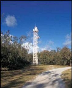 The AMSA relinquished management of the lightstation historic precinct in 2003. The AMSA leases a small area (Lot 1 – Appendix 1, Figure 9) nearby. This contains the current navigation aids (Figure 8) and AMSA personnel and contractors sometimes need to cross the historic precinct in order to access this light. Easements over the surrounding lease permit this. The AMSA is aware of the cultural significance of the lightstation. The AMSA must operate in accordance with the Lady Elliot Island Lightstation Heritage Management Plan when transiting the precinct to conduct observations or maintenance of the navigation light facility. The AMSA lease is for a standard 99-year term.

As previously identified, the GBRMPA’s actions with respect to heritage places will be consistent with the Commonwealth Heritage management principles. The following conservation policies are provided to guide the management and protection of the Commonwealth Heritage values of the Lady Elliot Island lightstation.
In the conservation policies below, the words in italics have the meanings defined in the Burra Charter – the definitions are reproduced in Appendix 2. The conservation policies aim to protect and conserve the Commonwealth Heritage values of the Lady Elliot Island lightstation. The policies are supported by implementation strategies and associated commentary has been provided to explain contextual matters.
Issue 1.0 Heritage management of Lady Elliot Island needs to be integrated into the overall environmental planning framework within the control of the GBRMPA
Policy 1.1 The GBRMPA recognises the significance of the Commonwealth Heritage values of the place.
Commentary
The GBRMPA works to conserve and protect Commonwealth Heritage values within its control. While heritage values are intangible, these values are usually expressed and recognised in the fabric of a place. Actions to protect the heritage significance of a place are therefore partly oriented towards the protection and conservation of heritage fabric.
Implementation strategy
- Conserve the lightstation to protect and enhance its historical significance.
- Ensure the continuation of past residential and current uses that maintain the original fabric of the site.
- Use the Burra Charter as the primary guide for the treatment of fabric (The Burra Charter is the primary reference for managing the heritage values of historic places).
Issue 2.0 Unauthorised access
Policy 2.1 Secure and protect the lightstation from unauthorised access.
Commentary
The relative remoteness of Lady Elliot Island makes access challenging and provides the lightstation with a natural security buffer. Most visitors to the island arrive by aircraft, with some trawlers anchoring up in the lee side of the island to escape poor weather, and other vessels as part of organised live-aboard dive voyages. Access to the island and precinct is limited by the Commonwealth Islands zoning, lease and permit requirements.
The private lessee controls access to the buildings within the historic precinct.
AMSA personnel and contractors periodically visit the AMSA lease (Lot 1) to inspect or maintain the navigation aids which are secured by a tall fence. They generally arrive by air, and do not usually need access to the historic precinct. There may be times when the AMSA will need to transport equipment and material to the island by sea and will need to traverse the historic lightstation area.
Implementation strategy
- Ensure that island visitors are aware of the heritage values of the lightstation through appropriate educational material.
- Ensure the heritage values of the lightstation are protected through controls on access to all buildings within the historic precinct.
- Protect access to the heritage precinct to comply with occupational health and safety requirements.
Issue 3.0 Community consultation
Policy 3.1 Undertake community, Traditional Owner and stakeholder consultation in the preparation, management and review of the management plan and where actions are likely to impact on the heritage values of the place.
Commentary
The development of a heritage management plan involves stakeholder and public consultation. Once a heritage management plan has been approved and implemented, consultation becomes part of the monitoring process. During reviews of the Heritage Management Plan, further consultation will occur. The GBRMPA has a range of established methods of community and stakeholder consultation, which it continues to use to satisfy this process.
Advisory committees
The GBRMPA aims to provide Australians with effective and meaningful consultation on heritage matters related to the Great Barrier Reef Marine Park. Part of this important process is achieved through regular meetings with the relevant Reef Advisory Committee (RAC) representing expertise-based stakeholders and the relevant Local Marine Advisory Committees representing the local communities. Communication with stakeholders also takes place as ongoing interaction between both lessees and the GBRMPA, and through a broader community engagement process.
Traditional Owners
The GBRMPA values the importance of involving Traditional Owners in the management processes of the Great Barrier Reef Marine Park. This value is reflected in the Great Barrier Reef Heritage Strategy and the GBRMPA Corporate Plan 2011-2014. These documents identify that the traditional affiliations, culture, heritage values and rights in relation to Traditional Owners must be taken into account in the management of the Marine Park.
The locality and the surrounding area are culturally significant to the Taribelang Bunda, Bailai, Gooreng Gooreng, and Gurang Aboriginal Traditional Owner groups. All the islands offshore from Bundaberg/Gladstone are included in the Port Curtis Coral Coast Native Title Claim which has been active since 2001. At the time of writing, the senior anthropologist from the Gurang Land Council (the former representative body for these Traditional Owner groups) was investigating their cultural links to Lady Elliot Island and other islands in the region. Their traditional estates range from the mouth of the Fitzroy River in the north to the town of Childers in the south (including both inland and offshore areas).
The GBRMPA will maintain consultation with Traditional Owners of the mainland through existing arrangements to ensure their continued involvement in the Heritage Management Plan. Traditional Owner consultation for the Lady Elliot Island area is achieved in many ways, one of which is through the Queensland South Native Title Services (a new body incorporating the former Gurang Land Council) as part of future act notifications prior to permits being granted for works on the island. The GBRMPA’s Indigenous Partnerships Group regularly meets with Traditional Owners and their representative bodies. The GBRMPA is also required to notify possible actions in relation to permit applications in accordance with the Native Title Act 1993.
Government
The GBRMPA recognises that maintaining strategies for liaison with all Commonwealth and State agencies with a relevant interest in heritage matters in the Great Barrier Reef Marine Park is crucial to the effective management of heritage values. Consequently, an ongoing action for the GBRMPA is to maintain this contact through formal and informal mechanisms.
Ongoing consultation with SEWPaC and the AMSA occurs for the purposes of heritage management, environmental management and ongoing maintenance of navigational aids. Consultation at the early stages of project development or initiation of works proposals has the advantage of avoiding unnecessary delays and costly plan revisions. Consultation with heritage experts can also minimise or mitigate significant impacts on heritage values. Where significant impacts are a possibility, consideration will be given by the GBRMPA as to whether a referral under the EPBC Act is required. This consideration includes the consideration of impacts to the environment that can occur away from the affected place. In the case of Lady Elliot lightstation for example, works and development to the resort or airfield could have impacts on the aesthetic values of the place.
Implementation strategy
- Undertake community consultation when reviewing the Heritage Management Plan in accordance with EPBC Regulations (regulation 10.03C).
- Continue to liaise as necessary with the Reef Advisory Committee, the relevant Local Marine Advisory Committees and local Indigenous communities in the management of the heritage values of the lightstation.
- Seek advice from local Indigenous communities when dealing with sensitive information and refer to the document Ask First: A Guide to Respecting Indigenous Heritage Places and Values (Australian Heritage Commission 2002) to guide consultations.
- Apply standard Commonwealth privacy and security requirements, for the management of sensitive information.
- Consult respective stakeholders in matters where sensitive commercial in confidence information is involved in the management of the place.
Issue 4.0 Protection and management of significant heritage fabric
Policy 4.1 Seek expert heritage advice and apply best heritage practice when considering works proposals or changes to the lightstation historic precinct or when considering major development to resort facilities.
Commentary
At certain times, advice may be sought from SEWPaC on works proposals impacting on Commonwealth Heritage values or where there is conflict between the management of different heritage values and operational requirements.
The GBRMPA will also seek professional heritage advice, where required, upon receipt of any proposals for development, adaptive reuse, or notification of damage to the heritage values of the lightstation or archaeological discoveries. This ensures that the integrity of the heritage values of the lightstation are protected. Advice may be from an internal source, other government agencies, a heritage professional or from an independent expert source, as appropriate.
As required under the Great Barrier Reef Marine Park Act 1975 any approved activities on the island are managed to reduce the potential for adverse effects on the heritage values of the lightstation. Potential activities on Lady Elliot Island are detailed in the lease agreements. The private lessee intends to continue to use the residential buildings for staff accommodation and proposes to use them for tourist accommodation. Apart from the need to consider the impact of proposals in the context of the EPBC Act any proposals for development or adaptive reuse must be approved in writing by the GBRMPA.
If it is intended to change the use of the residences from staff accommodation to tourist accommodation, care should be taken to assess any significant impact. In any case this may be an opportunity to return the place to an earlier form by reconstructing elements of fabric. Reconstruction should however only be considered with expert advice and in accordance with the Burra Charter. It is noted that reconstruction can often be inadvisable because of the likely loss of heritage values.
Implementation strategy
- Consult with the Heritage Division of SEWPaC at an early stage when considering proposals involving intervention in fabric or significant change.
- Use the self assessment tool as contained in Working Together: Managing Commonwealth Heritage Places (DEWHA 2008) to measure the likely extent of impact of a proposal.
- Consider the significance of any major proposal in the context of the referral provisions in the EPBC Act.
- Use the Matters of national environmental significance, Significant Impact Guidelines 1.1, EPBC Act 1999 (DEWHA 2009) to assist in identifying the significance of impacts.
- Prepare a heritage impact statement using expert advice identifying alternatives considered and the level of impacts on the heritage values, in line with the GBRMPA’s Environmental Impact Management processes.
- Continue to use the residential buildings for staff accommodation.
Issue 5.0 Treatment of archaeological fabric
Policy 5.1 In the event of new discoveries resulting from, for example, works that expose archaeological remains, cease work until appropriate expert advice is obtained.
Commentary
The Environmental Management Plan provisions outlined in the lease and permits applying to the private lease for Lady Elliot Island include response protocols to deal with emergencies and new discoveries on the island. The lease requires the establishment of the Lady Elliot Island Operations Committee, which includes a GBRMPA representative. The Operations Committee meetings are convened and chaired by the GBRMPA. The committee is responsible for the resolution of any issues that arise.
In the case of potential or actual damage to the heritage values of the lightstation or archaeological discoveries, the GBRMPA will seek heritage advice as detailed below.
Implementation strategy
- Seek expert advice in the event of unforeseen discoveries or disturbances.
Issue 6.0 Monitoring of heritage values
Policy 6.1 Report and monitor on an annual basis using the GBRMPA heritage register and record any change or impact on the heritage values of the place.
Commentary
The success of Commonwealth Heritage values conservation will be monitored through regular reporting, inspections and the use of the GBRMPA heritage register and associated databases.
In accordance with the EPBC Act (section 341ZB), the GBRMPA will maintain a heritage database for all Commonwealth Heritage places it manages including the Lady Elliot Island lightstation. Items that will be included on this database are:
- A description of the Commonwealth Heritage values;
- The current condition of the Commonwealth Heritage values as reported by the lessees and from inspections by the GBRMPA representatives;
- A record of all work carried out on the lightstation – this will include photographs, written documentation and drawings/plans;
- A record of all proposals for development or adaptive reuse of the lightstation;
- A record of all actual developments or adaptive reuse of the lightstation; and
- A record of all past and present heritage management plans for the lightstation.
The above information will be entered into the heritage database as soon as practicable after receipt.
The private lessee is required to report to the GBRMPA on the state of the Commonwealth Heritage values on an annual basis. This is detailed in the existing lease agreement with the lessee. Visual inspections of the heritage values will be conducted at a minimum of once every two years by relevant GBRMPA representatives; however, they are likely to be carried out at more regular intervals in conjunction with other requirements.
Implementation strategy
- Use of the heritage database in the management of the lightstation.
Issue 7.0 GBRMPA staff heritage training
Policy 7.1 Develop and implement a staff and community awareness training programme to improve the knowledge and respect for the heritage values of the place.
Commentary
The GBRMPA supports the continued development of its staff to improve management of the Marine Park. In addition to the corporate management training programme, relevant staff will be trained in the legislative requirements relating to heritage matters. Where necessary, appropriate training through internal (or external where relevant) courses on heritage matters will be held for managers and administrators who have responsibility for heritage management (including relevant stakeholders). Any specific Commonwealth Heritage training, which may be available and relevant, will also be included in the set of courses offered.
Implementation strategy
- Where necessary, and when resources and priorities permit, conduct appropriate training through internal (or external where relevant) courses on heritage matters for managers and administrators who have responsibility for heritage management including relevant stakeholders.
Issue 8.0 Heritage interpretation
Policy 8.1 Develop and prepare an interpretation plan using suitable interpretation measures such as signage, publications and organised events to raise management, occupant, community and visitor awareness.
Commentary
The GBRMPA maintains a comprehensive website, develops a range of information products for communicating messages to the wider community, and uses the ReefHQ aquarium and the Regional Engagement programme to further promote Commonwealth Heritage awareness in the broader community.
Other interpretation measures for discussion as part of this Heritage Management Plan include:
- Signage, publications or organised events to raise community awareness of the lightstation;
- Collecting and making available at Lady Elliot Island items of lightstation equipment with historical associations with the lightstation, and using them to interpret the history of the lightstation. Such items include lighthouse optical apparatus, and items that demonstrate the way of life of the lightkeepers; and
- Adaptive reuse possibilities:
- Using the keepers’ houses as specialised holiday accommodation requiring minimal intervention in significant fabric (e.g. holes made through walls – such as doorways, fixing equipment); and
- Utilising the lighthouse as a lookout/museum, subject to relevant safety issues and provided any use would not damage the structure or the heritage values associated with it.
Implementation strategy
- Request the cooperation of the AMSA in identifying the location and ownership of equipment formerly used at Lady Elliot Island lightstation. Negotiate the loan of any items still owned by the AMSA which would be suitable for interpretation.
- If the opportunity arises and priorities and resources permit, retain and enhance the interpretive qualities of the lightstation by:
- Regaining and replacing equipment and items associated with the lightstation;
- Using the lighthouse tower, the 1975 power house or other associated buildings, as interpretive facilities or additional accommodation, compatible with the significance of the place; and
- Using historical material when designing interpretive signs or displays and as part of the resort’s interpretive content.
Issue 9.0 Adaptive reuse
Policy 9.1 Consider only new adaptive reuses of the lightstation that are compatible with its Commonwealth Heritage values.
Commentary
Heritage places are often subject to change over time to provide for new uses. Making use of a heritage place is often a most effective measure to ensure its conservation. Adaptation can also have an adverse impact if a new use requires intrusive adaptation to the significant fabric. Adaptation of a lighthouse for a new use is not always an easy or suitable way to manage the place because of its distinctive form and because a new use often requires additional accommodation that confuses the stand-alone quality. Adaptation for new uses must therefore be controlled to ensure that the new use does not impact significantly on Commonwealth Heritage values.
Changes to the lightstation may be allowed where they are compatible with its heritage values.
Elements of the fabric of the lightstation, which are deemed to have a hazardous or harmful effect (for example, asbestos-related materials in a decayed, frayed or unstable condition or lead-based paint), may require containment, modification or, if there is no feasible or prudent alternative, their removal. If removal of material is necessary because of its hazardous state, legislative requirements govern this process. Where asbestos is not in an unstable condition its retention, as part of the significant fabric, is appropriate. Expert heritage advice should be sought to resolve any works proposals related to the removal of hazardous materials or other occupational health and safety matters.
Adaptation of the fabric may be permitted provided the cultural significance of the lightstation is not adversely affected. Such adaptation may include changes to bring the accommodation up to reasonable modern standards.
Implementation strategy
- Conserve the current colour scheme and distinctive character of the place by:
- Not permitting any additional structures attached to, or structural change in the near vicinity of, the place;
- Collecting, prior to and immediately following any conservation, maintenance, preservation or adaptation work, photographic evidence of the fabric for historical records and interpretive use;
- Undertaking paint scrapes to identify original colour coatings used on historic fabric; and
- Using protective coatings in the colours found by the paint scrape technique.
- Consider for the purposes of conservation, a viable economic use for the lightstation, to ensure the maintenance of all significant fabric and its protection from non-action.
- Approval in writing must be granted for any proposals for development or adaptive reuse.
- Consider the impacts that any proposed alterations or adaptations may have on the heritage values of the place.
- Use and comply with:
- The approved General Maintenance Program,
- The Building Management Plan,
- The Vegetation Management Plan, and
- The Environmental Management Plan.
- Compatible with the original fabric of the place and current occupational health and safety requirements:
- Retain in situ asbestos material that is stable, and contained to the extent that it is not in a hazardous condition;
- Remove hazardous, unstable and frayed asbestos in accordance with Australian legislative requirements;
- Replace removed hazardous asbestos with materials of the same profile, thickness and size as the fabric removed;
- Remove lead-based paint found to be in an uncontained, unstable or decaying condition;
- Upgrade the kitchen and bathroom facilities compatible with the fabric of the place;
- Install air-conditioning equipment in a discreet, visually benign and appropriate place; and
- Any proposals relating to works associated with hazardous materials should be undertaken with expert heritage and hazardous materials removal/management advice.
Issue 10.0 Works related to fabric conservation and repair
Policy 10.1 Protect and conserve the significant external and internal fabric of the lightstation, including existing buildings, layout and setting.
Commentary – conservation, repair or restoration
To protect and conserve heritage fabric, expert conservation processes may be needed. The application of these processes is often technically complicated and may require expert advice and work skills. Particular care is needed when repairing, restoring or reconstructing historic fabric to ensure that the Commonwealth Heritage values of the place are protected.
The heritage presentation of the place can also be improved by the careful removal of elements which are not significant. If the opportunity arises and when priorities and resources permit, these removals could take place when adaptive works are contemplated or future technology allows. If practical, original fabric or items removed from the place may be considered for retrieval and installation if appropriate.
Implementation strategy
- Conserve all the elements identified as significant in the table of physical elements (section 6.2) and their setting.
- If and when identified and necessary, seek expert materials conservation advice when considering repair, restoration and reconstruction of historic fabric.
Commentary – maintaining the fabric of the lightstation
Maintenance of heritage places sometimes involves the need to replace decayed or damaged fabric. The Burra Charter recommends doing only as much as necessary but as little as possible.
Implementation strategy
- Minimise the extent of any intervention in significant fabric by removing only those parts requiring replacement for structural or safety reasons.
- Replace or patch the damaged or decayed fabric with like but easily identified as new fabric inserted into the structure or material (Walker and Marquis-Kyle 2004).
Commentary – the setting
The history of changes to vegetation – including the results of past clearing and guano extraction, goat grazing, household gardening and revegetation – is part of the cultural significance of Lady Elliot Island. Where the protection of cultural values is inconsistent with other conservation aims, such conflicts should be resolved by finding a subtle balance. Instances of possible conflict include the casuarina trees that hang over the roofs of the houses. These mature trees, planted in 1961, are significant for their evidence of the first steps in revegetation, but they now pose a risk of damaging the brittle asbestos-cement roof sheeting in times of strong winds. In this case it might be appropriate to remove the trees as they approach senescence and replace them with younger specimens. Another possible conflict concerns introduced garden plants which demonstrate the pattern of household gardening by the light keepers, some of which are invasive and threaten the native vegetation.
The heritage setting around the lighthouse and lightstation is also important. In relation to the lighthouse, it is important to retain the lighthouse as a landmark feature seen from the sea. In relation to the lightstation as a whole, it is important to conserve lightstation fabric to retain its significance as fabric able to demonstrate the operation and living conditions associated with its historic use as a lightstation.
Implementation strategy
- In the process of managing and caring for the vegetation on Lady Elliot Island, take account of the cultural significance of plant material.
- Maintain evidence of past vegetation patterns or other plantings by planning and designing removal and replanting work in such a way that the heritage significance of the vegetation or planting is retained. Expert heritage advice should be sought in this regard.
- Recognise the importance of maintaining the lighthouse as a significant landmark feature seen from the sea. Buildings or other landscape works which obscure the visibility of the lighthouse from the sea should be avoided.
- Any major works impacting on the cultural significance of the landscape around the lighthouse and the lightstation should be prepared with advice from a heritage expert to ensure the cultural significance of this fabric is adequately protected.
- For planning purposes the area around the lightstation west of the airstrip should be treated as an area of particular sensitivity in relation to heritage values associated with the lightstation setting (Appendix 1, Figure 10). Any works proposed for this area should be controlled to protect the heritage significance of the place and its setting. Expert heritage advice should be sought to provide advice on any major works proposals.
Policy 11.1 Keep this Heritage Management Plan under review for improved management of the heritage values, and in any case review the plan within five years of its acceptance by the Minister as a plan consistent with the Commonwealth Heritage management principles.
Commentary
A management plan is affected by changes over time when administrative arrangements change, where leases require amendment and with technological advances. This Heritage Management Plan needs to be kept under review to take into account any change that might alter the basis for its application. In any case legislative requirements oblige Commonwealth agencies to review a management plan for a Commonwealth Heritage place once within every five-year period. This review will be undertaken in accordance with the EPBC Act and Regulations.
Implementation strategy
- Review management plan as required, or no later than five years after its adoption.
Action Item | Description | Who is Responsible | Timeline | Priority | Status |
1 | Prepare and have approved the Lady Elliot Island Lightstation Heritage Management Plan in accordance with the EPBC Regulations (regulation10.03C) | | 2012 | High | Completed |
2 | | Planning Unit | 2011 * | Medium | Completed |
3 | Undertake rust repairs and repaint the lighthouse | Field Management Coordination Unit | 2011 * | High | Ongoing |
4 | Remove trees from outside the lightstation residences as necessary for protection of the buildings in case of storms or falling limbs | Private lessee | 2009 * | Medium | Ongoing |
5 | Notify key positions of their responsibilities in relation to the Heritage Management Plan | Planning Unit | 2012 | High | Ongoing |
6 | Implement the management and conservation policies for the lightstation | GBRMPA and private lessee | 2009 * | Medium | Ongoing |
7 | Instigate and develop an interpretation plan using appropriate measures | Director Communication and Knowledge Management Group; and private lessee | 2012 | Medium | Commenced |
8 | Review and update this Heritage Management Plan every five years | GBRMPA | 2017 | Low | Ongoing |
9 | Identify information needs for management | Planning Unit | 2012 | Medium | Commenced |
* Has occurred in conjunction with the preparation of this plan.
Askunas and Company 1861, Flat Island guano, The Argus, 24 April, p. 3.
Australia ICOMOS 2000, The Burra Charter: The Australia ICOMOS charter for places of cultural significance 1999: with associated guidelines and code on the ethics of co-existence, Australia ICOMOS, Burwood, Vic.
Australian Heritage Commission 2002, Ask first: a guide to respecting Indigenous heritage places and values, AHC, Canberra.
Australian Maritime Safety Authority 1962, 'Lady Elliot Island Lighthouse Maintenance Records 1952-62', Unpublished report, to AMSA, Canberra.
Brewis, C.R.W. and Australia. Parliament 1912, Reports on the lighting of the coast of Australia, Government Printer, Melbourne.
Brisbane Courier 1895, Coast lights and beacons, the Portmaster's inspection, 18 February, p. 3.
Brisbane Courier 1898, The guano industry: chat with Captain Goodall, 16 July, p. 7.
Buchanan, S. 1994, The Lighthouse Keepers, Coral Coast Publications, Samford, Qld.
Chance Brothers and Company Limited n.d.a, Lady Elliot Isle. General Arrangement of 4th Order Apparatus, Chance Brothers and Company Limited, Lighthouse Engineers, Smethwick, Birmingham. Australian Maritime Safety Authority drawing CN09-053-01[1].TIF.
Chance Brothers and Company Limited n.d.b, Lady Elliot Isle, Queensland. 4th Order Single Flashing Optical Apparatus. Drawing No D336194. Chance Brothers and Company Limited, Lighthouse Engineers, Smethwick, Birmingham. Australian Maritime Safety Authority drawing CN09-052-01[1].TIF.
Chance Brothers and Company Limited n.d.c, Untitled drawing, Chance Brothers and Company Limited, Lighthouse Engineers, near Birmingham. Australian Maritime Safety Authority drawing CN07-044-01[1].TIF.
Department of Environment and Resource Management 2001, Woody Island lighthouse and ancillary building site, Queensland Heritage Register Place ID 602169, DERM, Brisbane, viewed 10/8/2011, <http://www.epa.qld.gov.au/chims/placeDetail.html;jsessionid=0a10032330d844ab096627a947d18cf4e1d90e14e159.e34NaN8SbNyKci0MaheOaheMchuMe6fznA5Pp7ftolbGmkTy?siteId=16990>.
Department of the Environment, Water, Heritage and the Arts 2008, Working Together: Managing Commonwealth Heritage Places, DEWHA, Canberra, viewed 10/08/11,
<http://www.environment.gov.au/heritage/publications/protecting/pubs/national/working-together-referral.pdf>.
Department of the Environment, Water, Heritage and the Arts 2009, Matters of national environmental significance, Significant Impact Guidelines 1.1, Environment Protection and Biodiversity Conservation Act 1999, DEWHA, Canberra, viewed 10/8/2011, <http://www.environment.gov.au/epbc/publications/pubs/nes-guidelines.pdf>.
Department of Sustainability, Environment, Water, Population and Communities 2011a, Do you need to obtain approval under the EPBC Act?, SEWPaC, Canberra, viewed 10/08/11,
<http://www.environment.gov.au/epbc/approval.html>.
Department of Sustainability, Environment, Water, Population and Communities 2011b, Search the Australian Heritage Database, SEWPaC, Canberra, viewed 10/08/11,
<http://www.environment.gov.au/cgi-bin/ahdb/search.pl>.
Gibbney, H.J. 1972, Heath, George Poynter (1830–1921), in Australian dictionary of biography, Volume 4, 1851-1890, eds G. Serle, B. Nairn, R. Ward, Melbourne University Press, Carlton, Vic., p. 372.
Great Barrier Reef Marine Park Authority 2005, Great Barrier Reef Marine Park Heritage Strategy, GBRMPA, Townsville, viewed 10/8/2011,
<http://www.gbrmpa.gov.au/__data/assets/pdf_file/0010/3403/GBRMPA_HeritageStrategy.pdf>.
Great Barrier Reef Marine Park Authority 2005, Home Page, GBRMPA, Townsville, viewed 10/8/2011,
<www.gbrmpa.gov.au>.
Kerr, J.S.1996, The conservation plan: a guide to the preparation of conservation plans for places of European cultural significance, 4th edn, National Trust of Australia, Sydney.
Laurence, S., Danvers, R., Lucas, G., Davie, J. and Pope, A. 1995, Conservation plan Lady Elliot Island lightstation Queensland, Danvers Architects, Adelaide.
Lighthouses of Australia Inc. 2011, LoA Inc., Knox City, Vic, viewed 10/8/2011, <http://www.lighthouse.net.au/lights/index.asp>.
QBuild Wide Bay Regional Office 2005, Maintenance assessment report for Lady Elliot Island, Department of Public Works, Wide Bay, Qld.
Queensland. Select Committee on the Rivers and Harbors of the Colony 1864, Rivers and harbors of the Colony, report from the Select Committee on the Rivers and Harbors of the Colony, together with the proceedings of the Committee, and minutes of evidence, Queensland Journals of the Legislative Council (with papers) 37, Government Printer, Brisbane.
Queensland State Archives: Public Works Department I 1877, North Reef Light House Capricornia Group, supply of material and construction of a light house, Series ID: 16433, Specifications for Queensland Government Buildings, Item ID1013929, Qld State Archives, Brisbane.
Reid, G. 1988, From dusk till dawn: a history of Australian lighthouses, Macmillan, South Melbourne.
Safety in Mines Testing and Research Station 2011, Asbestos Register
Lady Elliot Island, Report OH96671F1, SIMTARS, Redbank, Qld.
Thorburn, J.H. 1967, Major lighthouses of Queensland, Queensland Heritage 1(6): 18-29.
Walker, M. and Marquis-Kyle, P. 2004, The illustrated Burra Charter: good practice for heritage places, Australia ICOMOS Inc., Burwood, Vic.
Walsh, A. 2006, Lady Elliot Island: Great Barrier Reef Australia, Anthony Walsh, Sunnybank, Qld.
Watson, D. and McKay, J. 1994, Queensland architects of the 19th century: a biographical dictionary, Queensland Museum, Brisbane.
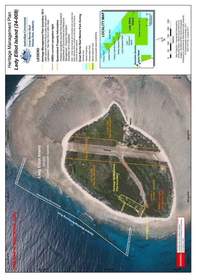
Figure 9. Map of Lady Elliot Island showing property information and identified uses
Figure 10. Map of Lady Elliot Island Lightstation Heritage Management Plan Area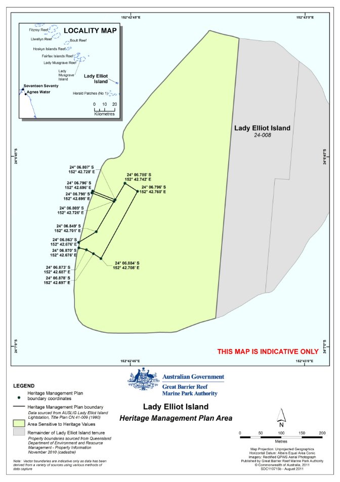
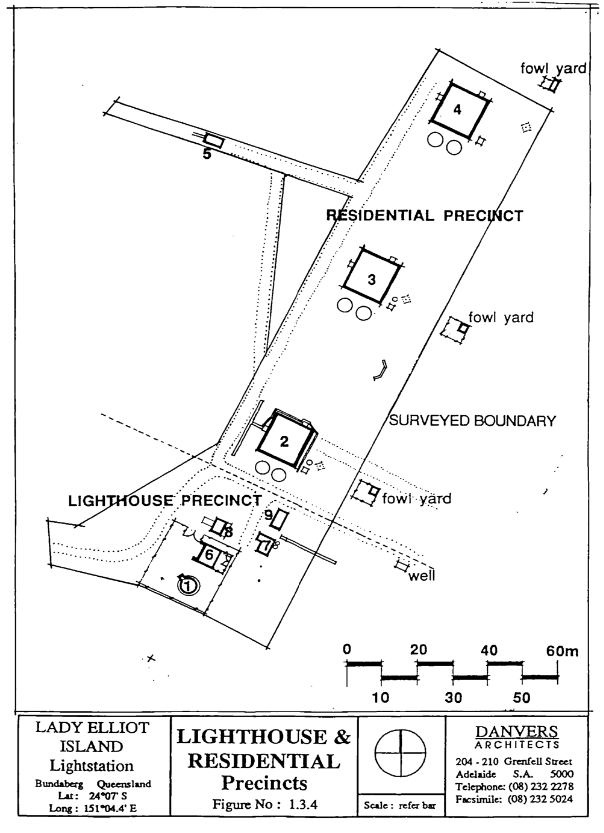
Figure 11. Lady Elliot Island lighthouse and residential precincts (Source: adapted from Laurence et al. 1995)
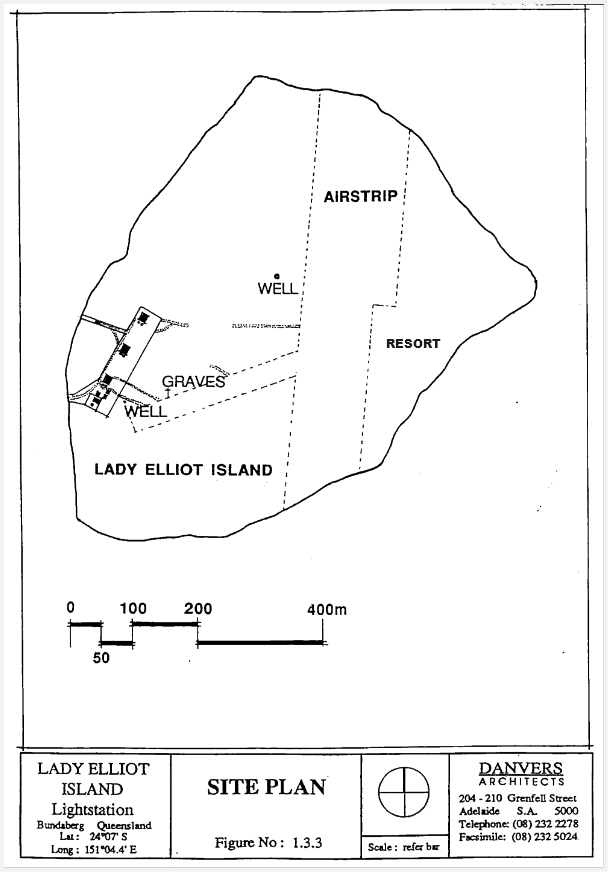
Figure 12. Lady Elliot Island lightstation site plan (Source: adapted from Laurence et al. 1995)
Place means site, area, land, landscape, building or other work, group of buildings or other works, and may include components, contents, spaces and views.
Fabric means all the physical material of the place including components, fixtures, contents, and objects.
Conservation means all the processes of looking after a place so as to retain its cultural significance.
Maintenance means the continuous protective care of the fabric and setting of a place, and is to be distinguished from repair. Repair involves restoration or reconstruction and should be treated accordingly.
Preservation means maintaining the fabric of a place in its existing state and retarding deterioration.
Restoration means returning the existing fabric of a place to a known earlier state by removing accretions or by reassembling existing components without the introduction of new material.
Reconstruction means returning a place to a known earlier state and is distinguished from restoration by the introduction of new material into the fabric.
Use means the functions of a place, as well as the activities and practices that may occur at the place.
Adaptation means modifying a place to suit the existing use or a proposed use.
Environment Protection and Biodiversity Conservation Regulations 2000 Schedule 7A – Management Plans for Commonwealth Heritage Places |
Legislation | Satisfied within |
A management plan must: |
(a) establish objectives for the identification, protection, conservation, presentation and transmission of the Commonwealth Heritage values of the place; and | Section 2 – Heritage Management Plan Objectives |
(b) provide a management framework that includes reference to any statutory requirements and agency mechanisms for the protection of the Commonwealth Heritage values of the place; and | Section 7 – Operational requirements |
(c) provide a comprehensive description of the place, including information about its location, physical features, condition, historical context and current uses; and | Section 4 – Lady Elliot Island Section 6 – The lightstation |
(d) provide a description of the Commonwealth Heritage values and any other heritage values of the place; and | Section 5 – Cultural significance |
(e) describe the condition of the Commonwealth Heritage values of the place; and | Section 6 – The lightstation |
(f) describe the method used to assess the Commonwealth Heritage values of the place; and | Section 1.2 – Preparation of this Management Plan |
(g) describe the current management requirements and goals including proposals for change and any potential pressures on the Commonwealth Heritage values of the place; and | Section 7 – Operational requirements Section 8 – Heritage Management Policies (Policy 4 and 9) |
(h) have policies to manage the Commonwealth Heritage values of a place, and include in those policies, guidance in relation to the following: | |
(i) the management and conservation processes to be used; | Section 8 – Heritage Management Policies (Policy 1) |
(ii) the access and security arrangements, including access to the area for indigenous people to maintain cultural traditions; | Section 8 – Heritage Management Policies (Policy 2) |
(iii) the stakeholder and community consultation and liaison arrangements; | Section 8 – Heritage Management Policies (Policy 3) |
(iv) the policies and protocols to ensure that indigenous people participate in the management process; | Section 8 – Heritage Management Policies (Policy 3) |
(v) the protocols for the management of sensitive information; | Not applicable |
(vi) the planning and management of works, development, adaptive reuse and property divestment proposals; | Section 8 – Heritage Management Policies (Policies 9 and 10) |
(vii) how unforeseen discoveries or disturbance of heritage are to be managed; | Section 8 – Heritage Management Policies (Policy 5) |
(viii) how, and under what circumstances, heritage advice is to be obtained; | Section 8 – Heritage Management Policies (Policy 4) |
(ix) how the condition of Commonwealth Heritage values is to be monitored and reported; | Section 8 – Heritage Management Policies (Policy 6) |
(x) how records of intervention and maintenance of a heritage places register are kept; | Section 8 – Heritage Management Policies (Policy 6) |
(xi) the research, training and resources needed to improve management; | Section 8 – Heritage Management Policies (Policy 7) |
(xii) how heritage values are to be interpreted and promoted; and | Section 8 – Heritage Management Policies (Policy 8) |
(i) include an implementation plan; and | Section 9 – Implementation Plan |
(j) show how the implementation of policies will be monitored; and | Section 9 – Implementation Plan |
(k) show how the management plan will be reviewed. | Section 8 – Heritage Management Policies (Policy 11) |

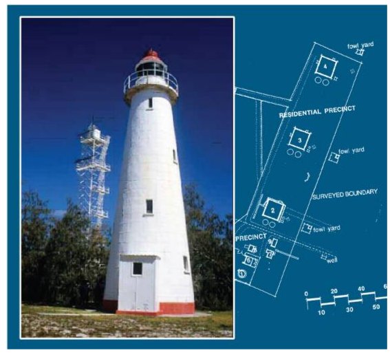
![]()

![]()
![]()

