1 Name
This instrument is the Antarctic Treaty (Environment Protection) Amendment (2012 to 2014 Measures—Protected Areas and Managed Areas) Proclamation 2014.
2 Commencement
This instrument commences on the day after it is registered.
3 Authority
This instrument is made under section 8 of the Antarctic Treaty (Environment Protection) Act 1980.
4 Schedules
Each instrument that is specified in a Schedule to this instrument is amended or repealed as set out in the applicable items in the Schedule concerned, and any other item in a Schedule to this instrument has effect according to its terms.
Schedule 1—Amendments
Antarctic Treaty (Environment Protection) Proclamation 2007
1 Section 4 (note)
Repeal the note, substitute:
Note: A number of expressions used in this Proclamation are defined in the Act, including the following:
(a) Antarctic specially managed area;
(b) Antarctic specially protected area;
(c) specially protected species;
(d) Treaty.
2 Section 5 (note)
Repeal the note, substitute:
Note: Details of Antarctic specially protected areas and Antarctic specially managed areas could in 2014 be viewed on the Antarctic Treaty Secretariat’s website (http://www.ats.aq).
3 Part 9 of Schedule 1
Repeal the Part, substitute:
Part 9—Antarctic specially protected area No. 109
1 Name and location
Moe Island, South Orkney Islands.
2 Description
Moe Island, South Orkney Islands, is a small irregularly‑shaped island lying 300 m off the south‑western extremity of Signy Island, separated by Fyr Channel. It is approximately 1.3 km from the northeast to southwest and 1 km from the northwest to southeast. The position of Moe Island on Admiralty Chart No. 1775 (60°44′S, 45°45′W) does not align closely with the more accurate coordinates in the map (60°44′S, 45°41′W).
The boundary coordinates of the Area, starting with the most north‑westerly position and moving clockwise, are as follows:
(a) 60°43′40″S, 45°42′15″W;
(b) 60°43′40″S, 45°40′30″W;
(c) 60°43′55″S, 45°40′10″W;
(d) 60°44′40″S, 45°40′10″W;
(e) 60°44′40″S, 45°42′15″W.
The Area includes all of Moe Island and unnamed adjacent islands and islets. The Area comprises all of the ice‑free ground, permanent ice and semi‑permanent ice found within the boundaries, but excludes the part of the marine environment that is further than 10 m offshore from the low tide water line (as indicated in the map).
Boundary markers have not been installed because the coast itself is a clearly defined and visually obvious boundary.
3 Map
4 Parts 11 to 13 of Schedule 1
Repeal the Parts, substitute:
Part 11—Antarctic specially protected area No. 111
1 Name and location
Southern Powell Island and adjacent islands, South Orkney Islands.
2 Description
The Area includes all of Powell Island south of the southern summit of John Peaks (415 m above sea level), and the whole of Fredriksen Island, Michelsen Island (a tidal peninsula at the southern tip of Powell Island), Christoffersen Island, Grey Island and unnamed adjacent islands. The Area comprises all of the ice‑free ground, permanent ice and semi‑permanent ice found within the boundaries, but excludes the part of the marine environment that is further than 10 m offshore from the low tide water line. All but the Crutchley Ice Piedmont of southern Powell Island are ice‑free in summer, though there are patches of semi‑permanent or late‑lying snow in places.
The corner coordinates of the Area are as follows:
(a) 60°42′35″S, 45°04′00″W (north‑western corner);
(b) 60°42′35″S, 44°58′00″W (north‑eastern corner);
(c) 60°45′30″S, 45°04′00″W (south‑western corner);
(d) 60°45′30″S, 44°58′00″W (south‑eastern corner).
3 Map
Part 12—Antarctic specially protected area No. 112
1 Name and location
Coppermine Peninsula, Robert Island, South Shetland Islands.
Latitude 62°24′S, longitude 59°30′W.
2 Description
Coppermine Peninsula is located at the north‑western end of Robert Island. It covers an elongated strip (2 km long by 500 m wide), from the isthmus connecting Robert Island to Cape Fort Williams. It has an irregular relief, with average heights of 30 to 40 m above sea level, and many protrusions reaching over 80 m above sea level, such as the basaltic columns of Neptune’s Cathedral and the snout near the facilities at Luis Risopatrón Base (Chile).
The Coppermine Peninsula extends from Cape Morris to Triplet Hill, separating Carlota and Coppermine Coves. This peninsula is the most westerly area of Robert Island and ends in the western tip at Fort Williams, a cape with striking features, such as Morris Rock, located in the coastal area.
The peninsula is connected to Robert Island through a terrace‑shaped isthmus featuring marine gravel, approximately 10 m above sea level and 250 m wide. The isthmus is interrupted to the east by a small horseshoe‑shaped hill. At the south‑eastern end of Coppermine Cape, the Triplet Hill emerges, with a height of 140 m above sea level.
The Area is shown in grey on the map.
3 Map
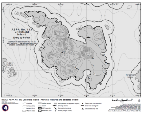
Part 13—Antarctic specially protected area No. 113
1 Name and location
Litchfield Island, Arthur Harbor, Anvers Island, Palmer Archipelago.
Latitude 64°46′S, longitude 64°06′W.
2 Description
Litchfield Island (0.34 km2, 64°46′15″S, 64°05′40″W) is located in Arthur Harbor approximately 1 500 m west of Palmer Station (US), Gamage Point, Anvers Island, in the region west of the Antarctic Peninsula known as the Palmer Archipelago.
The Area comprises all of Litchfield Island above the low tide water level, excluding all offshore islets and rocks. The coast itself is a clearly defined and visually obvious boundary feature, so boundary markers have not been installed. Several signs drawing attention to the protected status of the island are in place and legible, although deteriorating.
3 Map
5 Part 15 of Schedule 1
Repeal the Part, substitute:
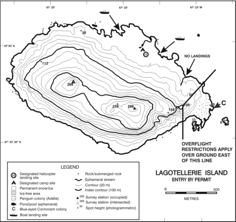
Part 15—Antarctic specially protected area No. 115
1 Name and location
Lagotellerie Island, Marguerite Bay, Graham Land.
2 Description
The Area includes all of Lagotellerie Island and unnamed adjacent islands and islets. The Area comprises all of the ice‑free ground, permanent ice and semi‑permanent ice found within the boundaries, but excludes the part of the marine environment that is further than 10 m offshore from the low tide water line. Boundary markers have not been installed because the coast itself is a clearly defined and visually obvious boundary.
Lagotellerie Island is steep‑sided and rocky, with approximately 13% permanent ice cover, most of which is on the southern slopes. The island rises to twin peaks of 268 m and 288 m above sea level, separated by a broad saddle at around 200 m above sea level, with precipitous cliffs up to this height on the southern, western and eastern sides.
The corner coordinates of the Area are as follows:
(a) 67°52′30″S, 67°27′00″W (north‑western corner);
(b) 67°52′30″S, 67°22′00″W (north‑eastern corner);
(c) 67°54′00″S, 67°27′00″W (south‑western corner);
(d) 67°54′00″S, 67°22′00″W (south‑eastern corner).
3 Map
6 Part 21 of Schedule 1
Repeal the Part, substitute:
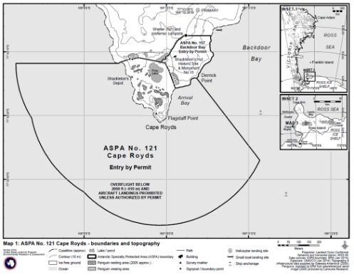
Part 21—Antarctic specially protected area No. 121
1 Name and location
Cape Royds, Ross Island.
Latitude 77°33′20″S, longitude 166°09′56″E.
2 Description
Cape Royds is located at the western extremity of Ross Island, McMurdo Sound, on a coastal strip of ice‑free land approximately 8 km wide, on the lower western slopes of Mount Erebus. The Area comprises both a terrestrial and a marine component.
The terrestrial component of the Area consists of ice‑free land within approximately 350 m of Flagstaff Point (77°33′21″S, 166°09′55″E) that is seasonally occupied by a breeding Adélie penguin (Pygoscelis adeliae) colony. The boundary captures all of the area occupied by breeding penguins and the main southern route used by the penguins to access the sea. The marine component comprises an area of sea within 500 m of the Cape Royds coastline, which includes the main penguin access route to the colony.
The boundary of the terrestrial component is as follows:
(a) starting at a small embayment at the north‑western corner of the terrestrial component, it extends northeast for 53 m to a survey mark which is an iron tube embedded in the ground;
(b) then east for 9 m to a signpost (77°33′11.2″S, 166°09′35.2″E);
(c) then east‑northeast for 30 m to a signpost (77°33′10.9″S, 166°09′39.4″E) halfway down the slope of a small hill;
(d) then southeast for 133 m to a signpost (77°33′11.8″S, 166°09′59.0″E) east of Pony Lake;
(e) then south‑southeast for 42 m to a signpost (77°33′12.9″S, 166°10′01.9″E);
(f) then 74 m to a signpost (77°33′15.2″S, 166°10′05.7″E) at the southern end of the penguin viewing area;
(g) then 18 m to the coast at Arrival Bay (77°33′15.8″S, 166°10′06.6″E);
(h) then along the coastline to Derrick Point.
The boundary from Pony Lake (signpost at 77°33′11.8″S, 166°09′59.0″E) to Derrick Point coincides with the southern boundary of ASPA No. 157 (Backdoor Bay).
The marine component of the Area comprises the area within 500 m of the mean high water coastline of Flagstaff Point. The boundary of the marine component is as follows:
(a) starting at Derrick Point (77°33′14.1″S, 166°10′22″E), it extends southwest for 500 m;
(b) then west, maintaining a distance of 500 m from the shore, to 77°33′11.8″S, 166°08′10″E;
(c) then due east 500 m to the coast at the north‑western corner of the terrestrial component (77°33′11.8″S, 166°9′25″E).
3 Map
7 Parts 23 and 24 of Schedule 1
Repeal the Parts, substitute:
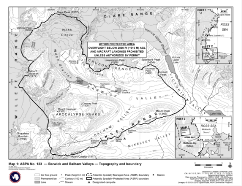
Part 23—Antarctic specially protected area No. 123
1 Name and location
Barwick and Balham Valleys, Southern Victoria Land.
Latitude 77°21′S, longitude 160°57′E.
2 Description
Barwick Valley is located approximately 65 km inland from the Ross Sea coast of southern Victoria Land. The Area includes Barwick and Balham Valleys and their respective catchments and is bordered on the south, west and north by the McKelvey Valley, the Willet Range and the divide between the Victoria and Barwick Valleys, respectively.
The boundary of the Area is as follows:
(a) starting from its eastern extremity in the lower Barwick Valley (around the confluence of the Barwick, Victoria and McKelvey Valleys), it extends south for several kilometres towards the ridge leading southwest to the summit of Mount Insel (1 345 m above sea level, 77°23.50′S, 161°30.74′E);
(b) then follows the high points of the ridge of the Insel Range over Halzen Mesa for 5.5 km before descending to a low pass between the McKelvey and Balham Valleys at the location of Bullseye Lake (722 m above sea level, 77°24.78′S, 161°14.41′E);
(c) then crosses the lake before ascending the ridge to a further high point on Canfield Mesa on the Insel Range (approximately 1 250 m above sea level);
(d) then over Green Mesa to follow Rude Spur to Mount Cassidy (1 917 m above sea level) and onwards to the upper reaches of the Balham Valley;
(e) then, as the terrain becomes gentler in the upper Balham and approximately 6.5 km southeast of the summit of Shapeless Mountain (2 736 m above sea level), the boundary extends north at between 1 800 m and 1 900 m above sea level towards the Huka Kapo Glacier and Apocalypse Peaks;
(f) then northwest from the Huka Kapo Glacier for approximately 9 km towards a prominent ridge leading to the summit of Mount Bastion (2 477 m above sea level, 77°19.18′S, 160°29.39′E);
(g) then north following the ridge to the top of McSaveney Spur;
(h) then following the upper ridgeline of the cirque containing Webb Icefall to the summit of Vishniac Peak (2 280 m above sea level, 77°14.71′S, 160°31.82′E);
(i) then northeast following the main ridge for 5 km to the summit of Skew Peak (2 537 m above sea level, 77°13.16′S, 160°42.07′E), located at the head of the Barwick Valley;
(j) then descending along the eastern ridge of Skew Peak above Webb Cirque, before following the catchment boundary south to Parker Mesa;
(k) then descending further to follow the upper ridge of The Fortress and the Cruzon Range, which is the dividing ridge between the catchments of the Victoria Upper Glacier and the Barwick Valley;
(l) then east along this ridge for approximately 12 km via Loewenstein Peak (1 539 m above sea level) and Shulman Peak (1 400 m above sea level) to Sponsors Peak (1 454 m above sea level, 77°18.2′S, 161°24.4′E);
(m) then descending the south‑eastern ridge of Sponsors Peak and Nickell Peak (approximately 1 400 m above sea level, 77°19.21′S, 161°28.25′E) to the lower Barwick to the eastern extremity of the Area, which is approximately 4 km northwest of Lake Vida, Victoria Valley.
3 Map
Part 24—Antarctic specially protected area No. 124
1 Name and location
Cape Crozier, Ross Island.
Latitude 77°28′54″S, longitude 169°19′53″E.
2 Description
Cape Crozier (77°30′30″S, 169°21′30″E) is at the eastern extremity of Ross Island, where an ice‑free area comprises the lower eastern slopes of Mount Terror. The Area is located in the vicinity of Post Office Hill (407 m above sea level), Bomb Peak (740 m above sea level) and The Knoll (360 m above sea level), extending to include Gamble, Topping and Kyle Cones, Igloo Spur and the adjacent marine environment, and an area of the Ross Ice Shelf where large cracks form as the shelf pushes against the land. These cracks are generally covered by fast‑ice, which is occupied annually by breeding emperor penguins.
The marine northern boundary of the Area extends 6.5 km along the 77°26′00″S line of latitude from 169°12′00″E to 169°28′00″E.
The marine western boundary extends 1.68 km south from the northern boundary to the coast, then the boundary continues as follows:
(a) south for a further 800 m to the edge of ice‑free ground before ascending to the summit of a low hill (approximately 300 m above sea level) above and east of the field hut (see map);
(b) then directly to the summit of Post Office Hill (407 m above sea level) at 77°27′55″S, 169°12′40″E;
(c) then following a straight line south to a point close to the summit of Bomb Peak (740 m above sea level) at 77°31′02″S, 169°11′30″E;
(d) then following the south‑eastern ridge of Bomb Peak to Igloo Spur at 77°32′00″S, 169°20′00″E;
(e) then due east along the 77°32′00″S line of latitude to the eastern boundary at 169°28′00″E;
(f) then due north to the marine northern boundary.
3 Map

8 Part 28 of Schedule 1
Repeal the Part, substitute:
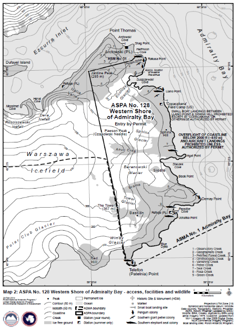
Part 28—Antarctic specially protected area No. 128
1 Name and location
Western Shore of Admiralty Bay, King George Island, South Shetland Islands.
Latitude 62°11′50″S, longitude 58°27′40″W.
2 Description
The Area is located on the western shore of Admiralty Bay on the southern side of King George Island, which is the largest of the South Shetland Islands archipelago. Arctowski Station (Poland) is located 0.5 km to the north. The Area is approximately 17 km².
The eastern boundary of the Area follows the coastline on the western shore of Admiralty Bay from the south‑eastern extremity of Halfmoon Cove (62°09′44″S, 58°27′49″W), south‑southeast for approximately 6 km to Demay Point.
The boundary then continues as follows:
(a) southwest following the coastline around Paradise Cove and Utchatka Point for approximately 3.5 km to Telefon (Patelnia) Point (62°14′03″S, 58°28′28″W);
(b) then north in a straight line for approximately 2.3 km to The Tower (367 m above sea level, 62°12′55″S, 58°28′48″W), a distinctive peak above Tower Glacier;
(c) then for a further 5.3 km to Jardine Peak (285 m above sea level, 62°10′03″S, 58°29′54″W);
(d) then descending east in a straight line from Jardine Peak for approximately 1.7 km to the highest point on Penguin Ridge, approximately 550 m from Arctowski Station;
(e) then northeast for approximately 0.3 km to the south‑eastern coast of Halfmoon Cove.
A marker is placed in Halfmoon Cove on the northern boundary of the Area at 62°09′43.7″S, 58°27′48.7″W, approximately 500 m southeast of Arctowski station.
3 Map
9 Parts 32 to 34 of Schedule 1
Repeal the Parts, substitute:
Part 32—Antarctic specially protected area No. 132
1 Name and location
Potter Peninsula, King George Island (Isla 25 de Mayo), South Shetland Islands.
2 Description
The Area is located on the eastern coast of Maxwell Bay, southwest of King George Island, between the southern tip of Mirounga Point (northwest of Potter Peninsula) and the outcrop known as “Spur 7”, on the north‑eastern border of Stranger Point. The area stretches along the coastal strip at low tide water levels up to the cliff edge, which reaches heights of 15 to 50 m above sea level. The front of the cliff edge is included within the Area. This coastal strip has a variable width, stretching up to 500 m from the shore at low tide water levels. The Area mainly comprises raised beaches.
On the map, permanent water bodies are shown in broken diagonal lines.
3 Map

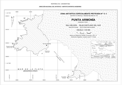
Part 33—Antarctic specially protected area No. 133
1 Name and location
Harmony Point, Nelson Island, South Shetland Islands.
Latitude 62°18′S, longitude 59°14′W.
2 Description
The Area is located on the western coast of Nelson Island (62°18′S, 59°14′W), between the King George (25 de Mayo) Island to the northeast, and the Robert Island to the southwest, and includes Harmony Point and the Toe, the sector covered by ice and the adjacent marine area.
On the map:
(a) the ice‑free areas are indicated by continuous diagonal lines; and
(b) the areas covered in ice are indicated with a dotted pattern.
3 Map
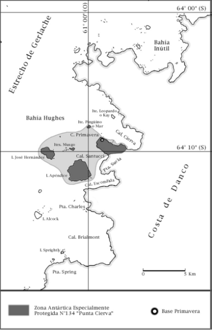
Part 34—Antarctic specially protected area No. 134
1 Name and location
Cierva Point and Offshore Islands, Danco Coast, Antarctic Peninsula.
Latitude 64°10′1.05″S, longitude 60°56′38.06″W.
2 Description
Cierva Point is located on the southern coast of Cierva Cove, to the north of Hughes Bay, between the Danco and Palmer Coasts, in the north‑western portion of the Antarctic Peninsula. The site comprises the ice‑free area between the south‑western coast of Cierva Cove and the north‑eastern coast of Santucci Cove. Also included are Apéndice Island (64°11′41.99″S, 61°1′3.25″W) and José Hernández Island (64°10′10.06″S, 61°6′11.34″W) and Moss Islet (64°10′2.22″S, 61°1′49.43″W) and Penguin Islet (64°8′35.90″S, 60°59′11.43″W), found to the west‑southwest of Cierva Point. Although the intertidal zone of each of these areas is included in the Area, the subtidal marine environment is not.
Primavera Base (Argentina) and its associated installations, as well as the beach area utilised for access to the base, are excluded from the Area.
On the map, the shaded area indicates the group of sites that make up the Area. However the subtidal marine environment between the continental and insular portions is not included in the Area.
3 Map
10 Parts 40 to 42 of Schedule 1
Repeal the Parts, substitute:
Part 40—Antarctic specially protected area No. 140
1 Name and location
Parts of Deception Island, South Shetland Islands.
2 Description
The Area comprises 11 sites. The sites are lettered A to L (excluding I), in a clockwise direction from the southwest of the caldera, and are referred to by the most prominent named geographical feature associated with each site. Boundary coordinates are listed below, but as many of the boundaries follow natural features, the boundary description outlines should also be consulted.
Boundary coordinates for the sites (other than Site J) are numbered, with number 1 the most northerly coordinate and further coordinates numbered sequentially in a clockwise direction around each site. In the tables below, the item number is the same as the boundary coordinate number.
Site A—Collins Point
The site comprises the north‑facing slopes between Collins Point and the unnamed point 1.15 km to the east (0.6 km west of Entrance Point), directly opposite Fildes Point, and extending from the back of the beach to a ridge extending up to approximately 1 km inland from the shoreline.
The eastern boundary of the site runs south from the shore at the unnamed point 0.6 km west of Entrance Point, following the outline of a ridge to 184 m above sea level. The western boundary extends from Collins Point, following a ridge south to 145 m above sea level. The southern boundary is demarcated by the arcuate ridge crest (following a line of summits east to west at 172 m, 223 m and 214 m above sea level) joining points at 184 m and 145 m above sea level. The beach area, including the Collins Point light beacon (maintained by the Chilean Navy), to the 10 m contour is excluded from the site.
Boundary coordinates for Site A—Collins Point |
Item | Latitude | Longitude |
1 | 62°59′50″S | 60°33′55″W |
2 | 63°00′06″S | 60°33′51″W |
3 | 63°00′16″S | 60°34′27″W |
4 | 63°00′15″S | 60°34′53″W |
5 | 63°00′06″S | 60°35′15″W |
6 | 62°59′47″S | 60°35′19″W |
7 | 62°59′59″S | 60°34′48″W |
8 | 62°59′49″S | 60°34′07″W |
Site B—Crater Lake
The site comprises Crater Lake and its shoreline, the flat ground to its north and the scoria‑covered lava tongue to the south.
The northern boundary extends along the foot of the slope to the north of the broad valley approximately 300 m north of Crater Lake (at approximately 30 m above sea level). The western boundary follows the ridgeline immediately west of the lake, and to the east of the small unnamed lake at 62°59′00″S, 60°40′30″W. The south‑western and southern boundaries follow the top of the slope (at approximately 80 m above sea level) that extends to the southwest and south of the lake. The eastern boundary passes to the east of the lava tongue south of Crater Lake, around the eastern rim of the lake and approximately 300 m across the flat plain to the north of the Crater Lake.
Boundary coordinates for Site B—Crater Lake |
Item | Latitude | Longitude |
1 | 62°58′48″S | 60°40′02″W |
2 | 62°58′50″S | 60°39′45″W |
3 | 62°58′56″S | 60°39′52″W |
4 | 62°59′01″S | 60°39′37″W |
5 | 62°59′11″S | 60°39′47″W |
6 | 62°59′18″S | 60°39′45″W |
7 | 62°59′16″S | 60°40′15″W |
8 | 62°59′04″S | 60°40′31″W |
9 | 62°58′56″S | 60°40′25″W |
Site C—Caliente Hill, southern end of Fumarole Bay
The site comprises a narrow line of fumaroles extending approximately 40 m by 3 m along the gently sloping summit ridge at approximately 95 to 107 m above sea level on Caliente Hill, above the north‑western side of Albufera Lagoon northwest of Decepción Station (Argentina) at the southern end of Fumarole Bay.
The site includes all the ground above the 90 m contour on the hill, with the exception of the ground southeast of a point 10 m northwest of the cairn (62°58′27″S, 60°42′31″W) at the south‑eastern end of the ridge. Access to the cairn at the south‑eastern end of the ridge is not restricted.
Boundary coordinates for Site C—Caliente Hill |
Item | Latitude | Longitude |
1 | 62°58′33″S | 60°42′12″W |
2 | 62°58′27″S | 60°42′28″W |
3 | 62°58′29″S | 60°42′33″W |
4 | 62°58′25″S | 60°42′51″W |
Site D—Fumarole Bay
The site comprises the unstable moist scree slopes below the precipitous lava cliffs on the eastern side of the southern end of Stonethrow Ridge to the break‑of‑slope beyond the beach west of mid‑Fumarole Bay.
The southern end of the cliffs ends in a prominent ridge sloping southeast down to the beach. The southern boundary of the site extends from the base of this ridge (at approximately 10 m above sea level) along the ridge line to the base of the cliffs at approximately 50 m above sea level. The western boundary follows the limit of the scree at the base of the cliffs roughly north for 800 m at approximately 50 m above sea level. The eastern boundary extends north along the break‑of‑slope at the back of the beach for 800 m, including all the large boulders. The northern boundary (approximately 100 m in length) joins the break‑of‑slope at the back of the beach to the scree at the base of the lava flow cliffs. The flat beach area from the shore, including 2 prominent intertidal fumaroles to the south of Fumarole Bay, to the break‑of‑slope is excluded from the site.
Boundary coordinates for Site D—Fumarole Bay |
Item | Latitude | Longitude |
1 | 62°57′42″S | 60°43′05″W |
2 | 62°58′04″S | 60°42′42″W |
3 | 62°57′53″S | 60°43′08″W |
4 | 62°57′43″S | 60°43′13″W |
Site E—west of Stonethrow Ridge
The site comprises an area of fumarole activity and includes a red scoria cone at approximately 270 m above sea level, on the northern side of the east to west trending ridge, approximately 600 m south‑southwest of the highest point on Stonethrow Ridge (330 m above sea level), west of central Fumarole Bay. It comprises 2 fumaroles approximately 20 m apart, the more easterly fumarole being more highly vegetated with lichens, mosses and liverworts covering an area of approximately 15 m by 5 m.
The boundary extends to 10 m beyond all evidence of geothermal activity and the unheated ground linking the 2 fumaroles.
Boundary coordinates for Site E—west of Stonethrow Ridge |
Item | Latitude | Longitude |
1 | 62°57′51″S | 60°44′00″W |
2 | 62°57′54″S | 60°44′00″W |
3 | 62°57′54″S | 60°44′10″W |
4 | 62°57′51″S | 60°44′10″W |
Site F—Telefon Bay
The site incorporates several features created during the 1967 eruption in Telefon Bay, i.e. Pisagua Hill on the southern side of the site, the small shallow Ajmonecat Lake on the ash plain north of Stancomb Cove and the low flat ash plain extending from the shoreline of Telefon Bay to the steep slopes and lava outcrops approximately 0.5 km inland. Pisagua Hill was created as a new island in 1967, but is, as of 2014, joined to the main island by the aforementioned ash plain. At the northern end of the plain is Extremadura Cove, which was a lake until the narrow isthmus (approximately 2 m wide and 50 m long) separating it from Port Foster was breached in approximately 2006. Extremadura Cove is excluded from the site.
The northern shoreline of the lagoon (Stancomb Cove) at the southwest of Telefon Bay marks the southern boundary of the site, and the south‑western shore of the Extremadura Cove to the north of Telefon Bay marks the north‑eastern boundary of the site. The south‑eastern boundary extends along the shore south of Pisagua Hill, north to the shoreline of the Extremadura Cove at the northern end of Telefon Bay. The north‑western boundary is roughly delineated by the 10 m contour of Telefon Ridge that links Stancomb Cove to Extremadura Cove. Ajmonecat Lake (62°55′23″S, 60°40′45″W), including its shoreline, is included in the site. The shoreline of Telefon Bay is excluded from the site to allow access past the site.
Boundary coordinates for Site F—Telefon Bay |
Item | Latitude | Longitude |
1 | 62°55′02″S | 60°40′17″W |
2 | 62°55′11″S | 60°39′45″W |
3 | 62°55′35″S | 60°40′43″W |
4 | 62°55′30″S | 60°41′13″W |
5 | 62°55′21″S | 60°41′07″W |
Site G—Pendulum Cove
The site comprises the uneven gentle slope of coarse grey, crimson, and red scoria and occasional disintegrating blocks of yellowish tuff, east‑northeast of Crimson Hill and approximately 0.4 to 0.8 km east of Pendulum Cove. It extends approximately 500 m from west to east and is up to approximately 400 m wide from north to south. It was created largely by the 1969 eruption which destroyed the nearby abandoned Chilean Base (which is declared to be an historic site or an historic monument (site number 76 in the table in Schedule 1 to the Antarctic Treaty (Environment Protection — Historic Sites and Monuments) Proclamation 2007)). The site includes the slope and undulating plateau behind Pendulum Cove.
The western boundary follows the 40 m contour line and the eastern boundary follows the 140 m contour line east‑southeast of Pendulum Cove. The northern and southern boundaries follow the edge of the volcanic debris‑covered permanent ice that borders the site.
Boundary coordinates for Site G—Pendulum Cove |
Item | Latitude | Longitude |
1 | 62°56′10″S | 60°35′15″W |
2 | 62°56′20″S | 60°34′41″W |
3 | 62°56′28″S | 60°34′44″W |
4 | 62°56′21″S | 60°35′16″W |
Site H—Mount Pond
The site is located approximately 1.4 to 2 km north‑northwest of the summit of Mount Pond. The extensive area of geothermally‑heated ground includes an area (approximately 150 m by 500 m) on the north‑eastern side of the gently sloping upper part of a broad ridge at approximately 385 to 500 m above sea level.
The northern boundary extends along the 62°55′51″S line of latitude, the southern boundary extends along the 62°56′12″S line of latitude and the eastern boundary extends along the 60°33′30″W line of longitude. The western boundary follows the ridgeline of the broad ridge that slopes north‑northwest from the summit of Mount Pond between 60°33′48″W and 60°34′51″W.
Boundary coordinates for Site H—Mount Pond |
Item | Latitude | Longitude |
1 | 62°55′51″S | 60°33′30″W |
2 | 62°56′12″S | 60°33′30″W |
3 | 62°56′12″S | 60°33′48″W |
4 | 62°55′57″S | 60°34′42″W |
5 | 62°55′51″S | 60°34′42″W |
Site J—Perchuć Cone
This ash cone lies approximately 750 m northeast of Ronald Hill and comprises a very narrow line of fumaroles and adjacent geothermally‑heated ground on the west‑facing slope at approximately 160 to 170 m above sea level. The geothermal area covers approximately 25 m by 10 m, and the fine ash and lapilli surface of the entire slope is very vulnerable to pedestrian damage.
The boundary encompasses all of the ash and cinder cone referred to as Perchuć Cone.
The site is located at 62°58′02″S, 60°33′39″W.
Site K—Ronald Hill to Kroner Lake
The site includes the circular flat plain of the crater immediately to the south of Ronald Hill, and extends along the prominent broad shallow outwash gulley with a low bank on either side, leading south to Kroner Lake. The site also includes the intertidal geothermal lagoon (Kroner Lake) as it is part of the same volcanological feature.
The boundary surrounds the crater basin, gulley, Kroner Lake and an area between approximately 100 m and 150 m wide around the lake. A corridor below Ronald Hill, from the break‑of‑slope to the lowermost massive boulders approximately 10 to 20 m beyond, remains outside the boundary to allow access past the Area.
Boundary coordinates for Site K—Ronald Hill to Kroner Lake |
Item | Latitude | Longitude |
1 | 62°58′25″S | 60°34′22″W |
2 | 62°58′32″S | 60°34′20″W |
3 | 62°58′34″S | 60°34′27″W |
4 | 62°58′41″S | 60°34′30″W |
5 | 62°58′44″S | 60°34′18″W |
6 | 62°58′50″S | 60°34′18″W |
7 | 62°58′58″S | 60°34′38″W |
8 | 62°58′49″S | 60°34′53″W |
9 | 62°58′41″S | 60°34′40″W |
10 | 62°58′24″S | 60°34′44″W |
Site L—South East Point
The site comprises an east to west trending rocky ridge approximately 0.7 km north of South East Point, extending west for approximately 250 m from the top of the sea cliff (approximately 20 m above sea level) to a point approximately 80 m above sea level. The northern edge of the ridge is a low vertical lava outcrop, giving way to a steep unstable slope leading to the floor of a gully parallel to the ridge. The southern side of the site is the gently sloping ridge crest covered with ash and lapilli.
The site extends 50 m north and south of the lava outcrop.
Boundary coordinates for Site L—South East Point |
Item | Latitude | Longitude |
1 | 62°58′53″S | 60°31′01″W |
2 | 62°58′56″S | 60°30′59″W |
3 | 62°58′57″S | 60°31′13″W |
4 | 62°58′55″S | 60°31′14″W |
3 Map

Part 41—Antarctic specially protected area No. 141
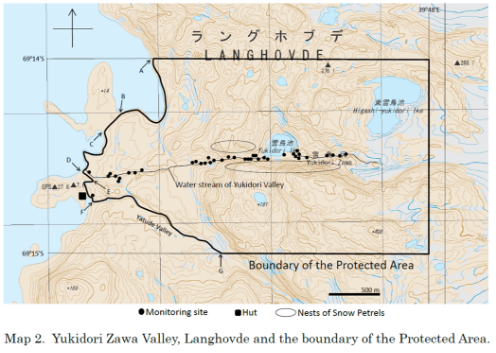
1 Name and location
Yukidori Valley, Langhovde, Lützow‑Holm Bay.
Latitude 69°00′30″S, longitude 39°46′00″E.
2 Description
The Yukidori Valley is located in the middle part of Langhovde, on the eastern coast of Lützow‑Holm Bay, continental Antarctica. The Area is 2.0 to 2.5 km by 1.8 km, located between a tongue of the ice cap and sea at the western end of the Valley. The Area does not include any marine area.
The Area comprises all the land within the following boundary lines:
(a) the eastern boundary follows a straight line due south from 69°14′00″S, 39°48′00″E to 69°14′00″S, 39°48′00″E;
(b) the northern boundary follows a straight line due west from 69°14′00″S, 39°48′00″E to the coastline at 69°14′00″S, 39°44′20″E;
(c) the southern boundary follows a straight line due west from 69°15′00″S, 39°48′00″E to the stream of Yatude Zawa at 69°15′00″S, 39°45′20″E (map point G);
(d) the western boundary between 69°14′00″S, 39°48′00″E (near map point A) and map point G, is delineated by the highwater line of the coast, rope boundaries and stream of Yatude Valley, as follows:
(i) the highwater line of the coast from 69°14′00″S, 39°44′.20″E (near map point A) to 69°14′13″S, 39°43′23″E (map point B);
(ii) rope boundaries from map point B to 69°14′17″S, 39°43′12″E (map point C);
(iii) the highwater line of the coast from map point C to 69°14′31″S, 39°42′57″E (map point D);
(iv) rope boundaries from map point D to 69°14′32″S, 39°43′.01″E (near map point F);
(v) the stream of Yatude Valley from 69°14′38″S, 39°43′.04″E (near map point F) to map point G.
3 Map
Part 42—Antarctic specially protected area No. 142
1 Name and location
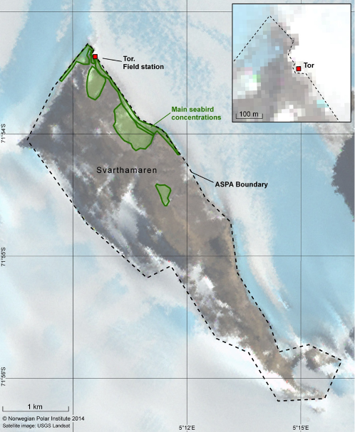
Svarthamaren, Mühlig‑Hofmannfjella, Dronning Maud Land.
Latitude 71°53′16″S, longitude 5°9′24″E to latitude 71°56′10″S, longitude 5°15′37″E.
2 Description
The Area is located in Mühlig‑Hoffmannfjella, Dronning Maud Land, stretching from approximately 71°53′16″S, 5°9′24″E in the northeast to approximately 71°56′10″S, 5°15′37″E in the southeast. The distance from the ice front is approximately 200 km. The Area covers approximately 7.5 km2, and consists of the ice‑free areas of the Svarthamaren nunatak, including the areas in the immediate vicinity of the ice‑free areas naturally belonging to the nunatak (i.e. rocks).
The Norwegian field station Tor is located in the Svarthamaren nunatak at 71°53′22″S, 5°9′34″E. The station, including a 10 m buffer zone around the station buildings, is excluded from the Svarthamaren ASPA.
3 Map
11 Part 54 of Schedule 1
Repeal the Part, substitute:
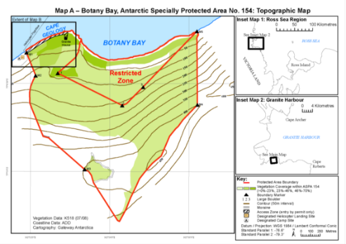
Part 54—Antarctic specially protected area No. 154
1 Name and location
Botany Bay, Cape Geology, Victoria Land.
Latitude 77°00′14″S, longitude 162°32′52″E.
2 Description
Cape Geology is located in the south‑western corner of Granite Harbour, southern Victoria Land, at 77°00′14″S, 162°32′52″E, approximately 100 km northwest of Ross Island. The Area consists of raised boulder beach terraces, weathered rocky steppes and irregular rock platforms around Cape Geology, rising rapidly to the south to include a well‑defined elevated cirque containing a small ice field.
The boundaries of the Area include the water catchment and encompass the elevated cirque from the small ice field down to the coastline.
The north‑western boundary is marked by a brass plaque in a boulder along the shoreline (77°00′19″S, 162°31′53″E (map point M1)) 400 m southwest of Cape Geology.
The boundary then continues as follows:
(a) starting at map point M1, it extends south‑southeast for 260 m to a large boulder (marked by a cairn) with terrier bolt (77°00′27″S, 162°33′08″E (map point M2)) at 118 m above sea level on the ridge above the campsite;
(b) then for 250 m up this ridge to a point at 162 m above sea level marked by an iron tube with bamboo pole;
(c) then for 300 m up this ridge to a large pointed rock at 255 m above sea level (77°00′40″S, 162°31′46″E) near the edge of the permanent ice field;
(d) then south for 150 m across the ice field to the western edge of a prominent line of exposed rock and moraine in the south‑western corner of the Area at 325 m above sea level;
(e) then following this line of rock east until the exposure is buried by the ice field;
(f) then southeast across the ice field for 500 m to the edge of a second and more prominent exposure at just over 400 m above sea level (77°00′59″S, 162°33′22″E (map point M3));
(g) then following the upper edge of this exposure, crossing the ice field southeast to approximately 325 m above sea level where the ice‑free eastern boundary ridge and the ice field converge (77°01′16″S, 162°34′15″E);
(h) then following the ridge crest northeast for 1 550 m to a low point on the ridge approximately 392 m above sea level (77°00′13″S, 162°36′10″E (map point M4));
(i) then descending due north to the coast at the eastern extremity of the boulder beach of Botany Bay (77°00′12″S, 162°36′12″E (map point M5)).
The mean high water mark of the coastline forms the northern boundary of the Area between map points M1 and M5.
3 Map
12 Part 62 of Schedule 1
Repeal the Part, substitute:
Part 62—Antarctic specially protected area No. 162
1 Name and location
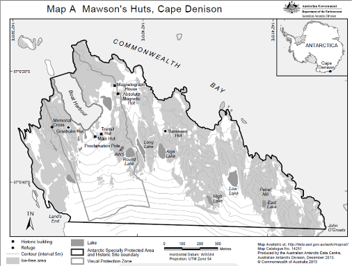
Mawson’s Huts, Cape Denison Commonwealth Bay, George V Land, East Antarctica.
Latitude 67°00′31″S, longitude 142°40′43″E.
2 Description
Cape Denison (67°00′35″S, 142°40′6″E) is located on the coast of Commonwealth Bay, a 60 km wide stretch of coast in George V Land some 3 000 km south of Hobart, Australia. The cape itself is a rugged, 1.5 km wide tongue of ice, snow, rock and moraine projecting into Commonwealth Bay from the steeply rising wall of the ice cap of continental Antarctica. On the western side of the cape is Boat Harbour, a 330 m long indentation in the coast.
The boundary of the Area is as follows:
(a) starting at Land’s End (67°00′47″S, 142°39′28″E) in the west, it extends along the coastline to the northern tip of the western shore of Boat Harbour (67°00′21″S, 142°39′28″E);
(b) then across the mouth of Boat Harbour (in a straight north‑easterly diagonal) to the eastern shore of Boat Harbour (67°00′21″S, 142°39′27″E), southwest of Penguin Knob;
(c) then southeast along the coastline down to John O’Groats (67°00′47″S, 142°41′27″E);
(d) then in a straight line back to Land’s End along the 67°00′47″S line of latitude.
With the exception of the boundary across the mouth of Boat Harbour, the northern coastal boundary extends to that land above the lowest tide.
The shoreline and the ice cliffs at both ends of the Cape (Land’s End and John O’Groats) form a clearly defined boundary. As such, no boundary markers have been installed.
3 Map
13 Part 70 of Schedule 1
Repeal the Part, substitute:
Part 70—Antarctic specially protected area No. 170
1 Name and location
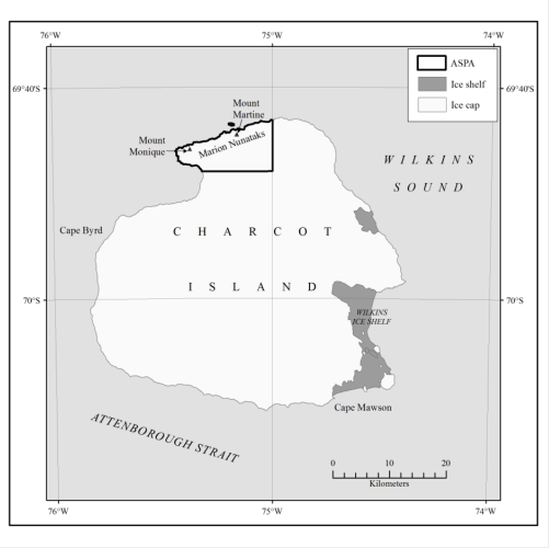
Marion Nunataks, Charcot Island, Antarctic Peninsula.
Latitude 69°45′S, longitude 75°15′W.
2 Description
Charcot Island is roughly circular in shape, approximately 50 km across and is separated from northwest Alexander Island (approximately 100 km away) by Wilkins Sound to the east and Attenborough Strait to the south.
The boundary of the Area is as follows:
(a) starting at the most north‑easterly corner of the Area, on the northern coast of Charcot Island, at 69°43′07″S, 75°00′00″W, it follows the coastline west to the point on the coast at 69°48′00″S, 75°19′19″W;
(b) then east inland to a point on the Charcot Island ice cap at 69°48′00″S, 75°00′00″W;
(c) then north to the coast at 69°43′07″S, 75°00′00″W.
The Area also includes Cheeseman Island, located at 69°43′24″S, 75°11′00″W.
There are no boundary markers demarcating the Area. The maximum dimensions of the Area are 9.2 km north to south and 17.0 km east to west (106.5 km2). The Area includes ice cap that extends at least 4 km to the south and east of Marion Nunataks, which is intended to act as a buffer zone to prevent accidental importation of species not native to the Area.
3 Map
14 At the end of Schedule 1
Add:
Part 73—Antarctic specially protected area No. 173
1 Name and location
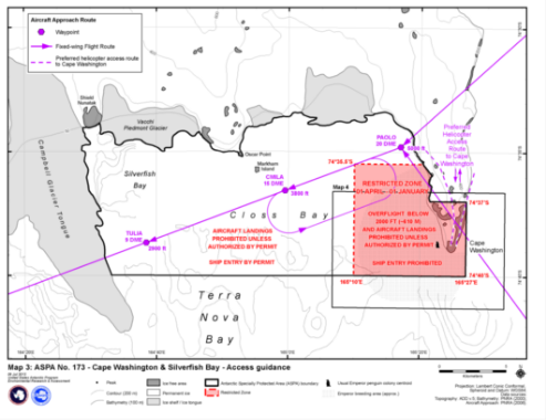
Cape Washington and Silverfish Bay, Northern Terra Nova Bay, Ross Sea.
Latitude 74°37.1′S, longitude 164°57.6′E.
2 Description
Cape Washington is located in northern Terra Nova Bay, 40 km east of Mario Zucchelli Station (Italy). The Area is 286 km2, of which the marine component is 279.5 km2 (98%) and the terrestrial component is 6.5 km2 (2%).
The boundary of the Area is as follows:
(a) starting at the north‑eastern corner at 74°37′S, 165°27′E, on the eastern coast of the Cape Washington peninsula, it extends due south for approximately 5.6 km to 74°40′S, 165°27′E;
(b) then due west across Closs Bay on the 74°40′S line of latitude for approximately 26.8 km to the Campbell Glacier Tongue;
(c) then following the eastern margin of the Campbell Glacier Tongue for approximately 11.2 km north to the coast at Shield Nunatak;
(d) then following the coastline east, around the Vacchi Piedmont Glacier, to the western coast of the Cape Washington peninsula, approximately 23 km in a straight line from Shield Nunatak;
(e) then following the coastline south for approximately 7.5 km towards the first prominent rock outcrop at 74°37.03′S on the western coast of the Cape Washington peninsula;
(f) then east from the coast along the 74°37′S line of latitude for approximately 2.8 km to the north‑eastern corner boundary point located on the eastern coast of the Cape Washington peninsula.
3 Map
Part 74—Antarctic specially protected area No. 174
1 Name and location
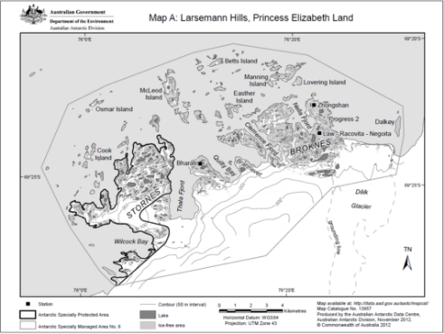
Stornes, Larsemann Hills, Princess Elizabeth Land.
Latitude 69°25′S, longitude 76°6′E.
2 Description
Stornes lies within the Larsemann Hills, a coastal ice‑free area in southern Prydz Bay, East Antarctica. Stornes is located between Thala Fjord and Wilcock Bay and is 21.13 km2 in area. The Area comprises the majority of Stornes, plus small unnamed promontories to the southwest. The Area does not have a marine component.
The Area boundary comprises the coastline (following the low tide mark) between a point on the western side of Thala Fjord at 69°25′29″S, 76°8′29″E (boundary point 1) to a point to the south of McCarthy Point at 69°28′40″S, 76°3′22″E (boundary point 25), then northeast following the coast line at the low tide mark back to boundary point 1. The remainder of the boundary largely follows the southern limit of rock outcrops between those boundary points. An indentation from the coast on the eastern side of the peninsula accommodates the potential need for vehicle landings and access to the inland and Broknes when ice conditions do not allow the use of preferred landings and routes elsewhere in the Larsemann Hills.
In the table, the item number is the same as the boundary coordinate number.
Boundary coordinates for ASPA No. 174 |
Item | Latitude | Longitude |
1 | 69°25′29″S | 76°8′29″E |
2 | 69°25′29″S | 76°8′6″E |
3 | 69°25′34″S | 76°7′45″E |
4 | 69°26′1″S | 76°5′60″E |
5 | 69°26′4″S | 76°5′52″E |
6 | 69°26′8″S | 76°5′44″E |
7 | 69°26′11″S | 76°5′38″E |
8 | 69°26′15″S | 76°5′37″E |
9 | 69°26′19″S | 76°5′38″E |
10 | 69°26′22″S | 76°5′44″E |
11 | 69°26′24″S | 76°5′51″E |
12 | 69°26′26″S | 76°6′1″E |
13 | 69°26′36″S | 76°8′12″E |
14 | 69°26′38″S | 76°8′21″E |
15 | 69°26′39″S | 76°8′25″E |
16 | 69°26′42″S | 76°8′28″E |
17 | 69°26′47″S | 76°8′30″E |
18 | 69°26′51″S | 76°8′29″E |
19 | 69°26′55″S | 76°8′26″E |
20 | 69°26′60″S | 76°8′22″E |
21 | 69°27′3″S | 76°8′18″E |
22 | 69°27′6″S | 76°8′14″E |
23 | 69°27′10″S | 76°8′8″E |
24 | 69°28′39″S | 76°3′36″E |
25 | 69°28′40″S | 76°3′22″E |
3 Map
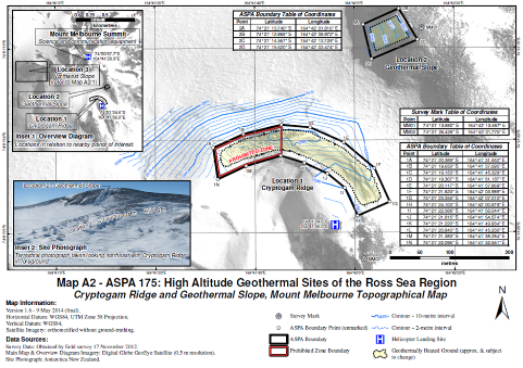
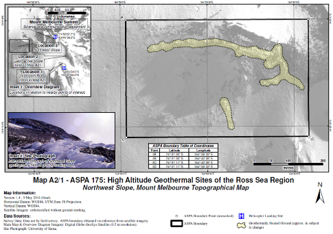
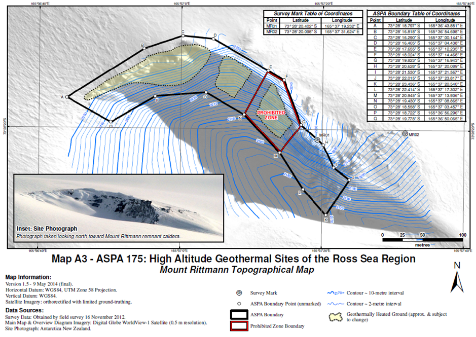
Part 75—Antarctic specially protected area No. 175
1 Name and location
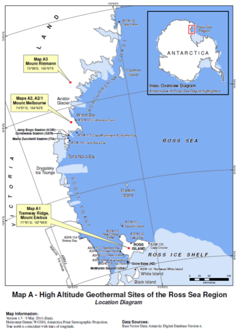
High Altitude Geothermal Sites of the Ross Sea Region (including parts of the summits of Mount Erebus, Ross Island and Mount Melbourne and Mount Rittmann), northern Victoria Land.
2 Description
The Area comprises 3 high altitude geothermal sites, Tramway Ridge on the summit of Mount Erebus (7731′S, 16706′E), 3 locations of geothermal activity on the summit of Mount Melbourne (7421′S, 16442′E), and the summit of Mount Rittmann (7328′S, 16537′E).
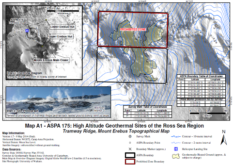
Tramway Ridge, Mount Erebus
Tramway Ridge is a ridge that rises to approximately 3 450 m above sea level on the north‑western slope of the main crater of Mount Erebus. The site is located along this ridge approximately 1.5 km from the main crater.
The boundary of the site comprises a rectangle of 200 m by 200.8 m which encompasses most of the geothermally heated ground of lower Tramway Ridge. The boundary is as follows:
(a) starting at the north‑western boundary corner at 7731′01.853″S, 16706′21.251″E (Point A), it extends south to the south‑western boundary corner at 7731′08.327″S, 16706′20.686″E (Point E);
(b) then east to the south‑eastern boundary corner at 7731′08.448″S, 16706′50.521″E (Point D);
(c) then north to the north‑eastern boundary corner at 7731′01.976″S, 16706′51.074″E (Point B);
(d) then back to Point A.
Mount Melbourne
Mount Melbourne is a stratovolcano located in northern Victoria Land, between Wood Bay and Terra Nova Bay, on the western side of the Ross Sea, and approximately 10 km east of Campbell Glacier.
The site consists of 3 separate locations, 2 on the main summit crater and a third on the north‑western slope of the mountain. On the south‑eastern rim of the main summit crater of Mount Melbourne, there are 2 adjacent designated locations.
The first location (Cryptogam Ridge) is a distinct crescent shaped ridge and consists of areas of snow‑covered unheated ground, snow‑free geothermally‑heated ground and ice‑hummocks covering steam emissions that extends approximately 40 m in all directions from the ridge line.
The boundary (see Map A2) is as follows:
(a) starting at the north‑western boundary corner at 74°21′20.389″S, 16441′31.652″E (Point 1A), it extends south approximately 50 m to the south‑western boundary corner at 7421′22.096″S, 16441′32.551″E (Point 1N);
(b) then east following the crescent shape of Cryptogam Ridge to the following unmarked points:
(i) 7421′21.383″S, 16441′38.254″E (Point 1M);
(ii) 7421′20.840″S, 16441′45.230″E (Point 1L);
(iii) 7421′21.220″S, 16441′49.934″E (Point 1K);
(iv) 7421′21.815″S, 16441′54.574″E (Point 1J);
(v) 7421′22.588″S, 16441′58.044″E (Point 1I);
(c) then to the south‑eastern boundary corner at 7421′24.103″S, 16442′00.579″E (Point 1H);
(d) then north to the north‑eastern boundary corner at 7421′23.355″S, 16442′07.010″E (Point 1G);
(e) then west following the crescent shape of Cryptogam Ridge to the following unmarked points:
(i) 7421′21.523″S, 16442′03.989″E (Point 1F);
(ii) 7421′20.117″S, 16441′57.869″E (Point 1E);
(iii) 7421′19.307″S, 16441′51.137″E (Point 1D);
(iv) 7421′19.153″S, 16441′45.329″E (Point 1C);
(v) 7421′19.650″S, 16441′37.695″E (Point 1B);
(f) then back to Point 1A.
Both the northern and southern boundaries are located below the ice‑free ridge.
The second location (Geothermal Slope) on the south‑eastern rim of the main summit crater of Mount Melbourne is adjacent to Cryptogam Ridge on a slope leading up the eastern rim of the summit crater. Geothermal activity is evident on the hill slope as crevasses and ice towers extending up the steep caldera rim, approximately 50 m wide.
The boundary is as follows:
(a) starting at the north‑western boundary corner at 7421′13.740″S, 16442′01.816″E (Point 2A), it extends south approximately 50 m to the south‑western boundary corner at 7421′15.620″S, 16442′03.474″E (Point 2D);
(b) then east up the slope to the south‑eastern boundary corner at 7421′14.567″S, 16442′12.729″E (Point 2C);
(c) then north to the north‑eastern boundary corner at 7421′12.865″S, 16442′08.972″E (Point 2B);
(d) then back to Point 2A.
The third location (Northwest Slope) is on the north‑western slopes of the volcano approximately 1.5 km northwest of Cryptogam Ridge. Geothermal activity is evident as a northwest to southeast trending line of ice towers and small patches of bare ground along the edge of a steep cliff. The boundaries for the location were not surveyed in the field but obtained via inference from satellite imagery.
The boundary is as follows:
(a) starting at the north‑western boundary corner at 7421′00″S, 16439′02″E (Point 3A), it extends south downslope to the south‑western boundary corner at 7421′11″S, 16439′02″E (Point 3D);
(b) then east to the south‑eastern boundary corner at 7421′11″S, 16442′05″E (Point 3C);
(c) then north upslope to the north‑eastern boundary corner at 7421′00″S, 16440′05″E (Point 3B);
(d) then back to Point 3A.
Mount Rittmann
Mount Rittmann is located in the Mountaineer Range on the southern side of the Aviator Glacier, between the Pilot Glacier and the head of the Icebreaker Glacier in northern Victoria Land. It rises to 2 600 m above sea level, is approximately 103 km north of Mount Melbourne and approximately 50 km inland from the coast.
The site comprises the entire exposed caldera of Mount Rittmann.
The boundary is as follows:
(a) starting at the most westerly boundary corner at the western edge of the caldera rim at 7328′18.797″S, 16536′43.851″E (Point A), it follows the caldera rim east to the following unmarked points:
(i) 7328′16.818″S, 16536′54.698″E (Point B);
(ii) 7328′16.290″S, 16537′00.144″E (Point C);
(iii) 7328′16.405″S, 16537′04.438″E (Point D);
(iv) 7328′17.655″S, 16537′12.235″E (Point E);
(v) 7328′18.024″S, 16537′14.468″E (Point F);
(vi) 7328′19.823″S, 16537′16.943″E (Point G);
(vii) 7328′20.628″S, 16537′20.089″E (Point H);
(viii) 7328′21.530″S, 16537′21.567″E (Point I);
(b) then to the most easterly boundary corner at 7328′22.015″S, 16537′23.817″E (Point J);
(c) then south downslope to the south‑eastern boundary corner at 7328′23.436″S, 16537′20.540″E (Point K);
(d) then following the bottom of the steep slope below the caldera rim and ice‑free areas to the following unmarked points:
(i) 7328′22.414″S, 16537′17.302″E (Point L);
(ii) 7328′20.945″S, 16537′13.936″E (Point M);
(iii) 7328′19.430″S, 16537′08.865″E (Point N);
(iv) 7328′18.558″S, 16537′03.457″E (Point O);
(v) 7328′18.722″S, 16537′56.296″E (Point P);
(vi) 7328′19.778″S, 16536′50.065″E (Point Q);
(e) then upslope to Point A.
3 Maps
15 Part 4 of Schedule 2
Repeal the Part, substitute:
Part 4—Antarctic specially managed area No. 4
1 Name and location
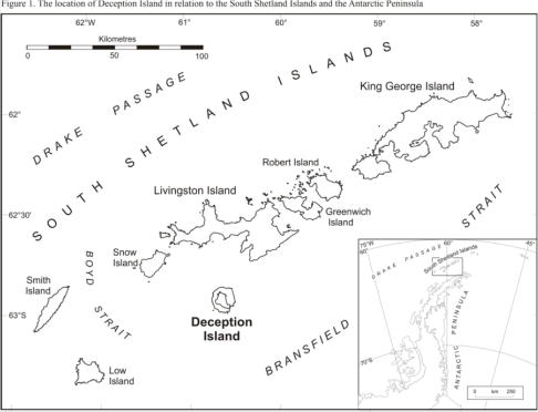
Deception Island, South Shetland Islands, Antarctica.
Latitude 62°57′S, longitude 60°38′W.
2 Description
Deception Island, South Shetland Islands, is located in the Bransfield Strait at the southern end of the South Shetland Islands, off the north‑western coast of the Antarctic Peninsula (Figures 1 and 2). The boundary of the Area comprises the outer coastline of the island above the low tide water level. It includes the waters and seabed of Port Foster to the north of a line drawn across Neptunes Bellows between Entrance Point and Cathedral Crags. No boundary markers are required for the Area, as the coast is clearly defined and visually obvious.
3 Map
Schedule 2—Repeals
Antarctic Treaty (Environment Protection) Proclamation 2007
1 Section 3
Repeal the section.
2 Section 6
Repeal the section.
3 Parts 14, 18, 25, 30, 44, 46 and 50 of Schedule 1
Repeal the Parts.
4 Part 3 of Schedule 2
Repeal the Part.