1 Name
This is the Antarctic Treaty (Environment Protection) Amendment (Protected Areas and Managed Areas) Proclamation 2016.
2 Commencement
(1) Each provision of this instrument specified in column 1 of the table commences, or is taken to have commenced, in accordance with column 2 of the table. Any other statement in column 2 has effect according to its terms.
Commencement information |
Column 1 | Column 2 | Column 3 |
Provisions | Commencement | Date/Details |
1. The whole of this instrument | The day after this instrument is registered. | 15 December 2016 |
Note: This table relates only to the provisions of this instrument as originally made. It will not be amended to deal with any later amendments of this instrument.
(2) Any information in column 3 of the table is not part of this instrument. Information may be inserted in this column, or information in it may be edited, in any published version of this instrument.
3 Authority
This instrument is made under subsection 8(6) of the Antarctic Treaty (Environment Protection) Act 1980.
4 Schedules
Each instrument that is specified in a Schedule to this instrument is amended or repealed as set out in the applicable items in the Schedule concerned, and any other item in a Schedule to this instrument has effect according to its terms.
Schedule 1—Amendments
Antarctic Treaty (Environment Protection) Proclamation 2007
1 Part 1 of Schedule 1
Repeal the Part, substitute:
Part 1—Antarctic specially protected area No. 101
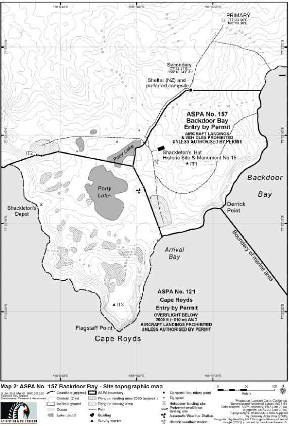
1 Name and location
Taylor Rookery, Mac.Robertson Land, East Antarctica.
67°27′S, 60°51′E.
2 Description
Taylor Rookery consists of the whole of the northernmost rock exposure on the east side of Taylor Glacier, Mac.Robertson Land (67°27′14″S, 60°53′00″E). Boundary coordinates for the Area are set out in the following table. The Area boundary follows the coastline (at the low tide mark) from a point at the north‑western corner of the Area at 67°27′04.9″S, 60°52′58.2″E (boundary point 1), in a roughly south‑easterly direction to boundary point 6 (67°27′27.8″S, 60°53′07.7″E). The boundary then continues in a westerly and then northerly direction (roughly following the limit of the ice free area) to boundary point 22 (67°27′18″S, 60°52′50.2″E) then follows the ice cliff north to boundary point 23 (67°27′5.3″S, 60°52′57.1″E) and then joins back to boundary point 1. There are no boundary markers delimiting the site.
Boundary coordinates for Taylor Rookery |
Boundary point | Latitude (S) | Longitude (E) |
1 | 67°27′04.9″ | 60°52′58.2″ |
2 | 67°27′17.1″ | 60°53′29.5″ |
3 | 67°27′17.7″ | 60°53′31.0″ |
4 | 67°27′21.6″ | 60°53′27.5″ |
5 | 67°27′22.4″ | 60°53′19.3″ |
6 | 67°27′27.8″ | 60°53′07.7″ |
7 | 67°27′29.1″ | 60°53′04.9″ |
8 | 67°27′29.8″ | 60°53′02.6″ |
9 | 67°27′30.1″ | 60°53′00.5″ |
10 | 67°27′29.8″ | 60°52′57.1″ |
11 | 67°27′29.3″ | 60°52′55.5″ |
12 | 67°27′28.0″ | 60°52′54.6″ |
13 | 67°27′27.4″ | 60°52′51.5″ |
14 | 67°27′27.9″ | 60°52′49.3″ |
15 | 67°27′28.7″ | 60°52′48.8″ |
16 | 67°27′28.9″ | 60°52′47.7″ |
17 | 67°27′28.9″ | 60°52′46.5″ |
18 | 67°27′28.3″ | 60°52′46.0″ |
19 | 67°27′24.9″ | 60°52′45.4″ |
20 | 67°27′20.7″ | 60°52′50.1″ |
21 | 67°27′19.3″ | 60°52′49.9″ |
22 | 67°27′18.0″ | 60°52′50.2″ |
Follows ice cliff north | | |
23 | 67°27′05.3″ | 60°52′57.1″ |
3 Map
2 Clause 1 of Part 2 of Schedule 1
Omit “MacRobertson”, substitute “Mac.Robertson”.
3 Clause 2 of Part 2 of Schedule 1
Omit “Rookey”, substitute “Rookery”.
4 Clause 2 of Part 2 of Schedule 1
Omit “MacRobertson”, substitute “Mac.Robertson”.
5 Part 19 of Schedule 1
Repeal the Part, substitute:
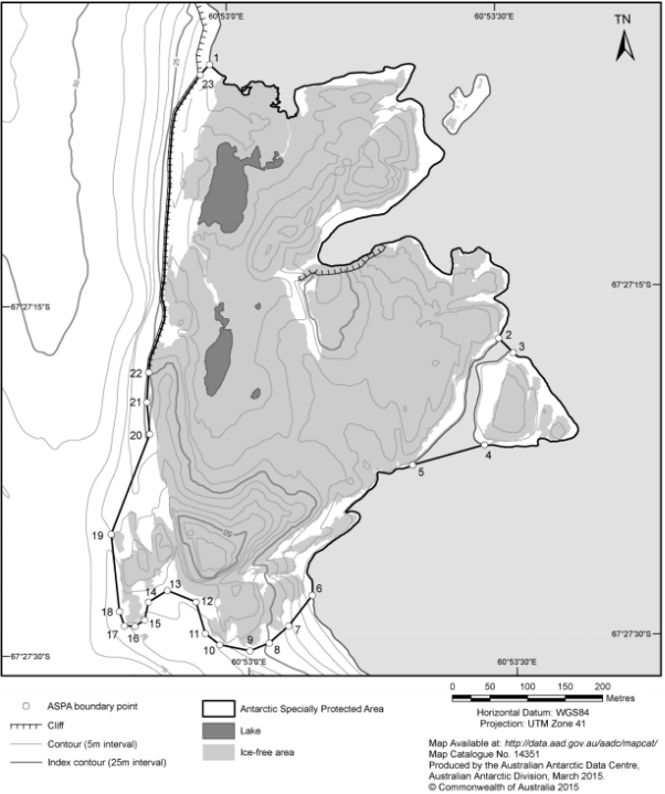
Part 19—Antarctic specially protected area No. 119
1 Name and location
Davis Valley and Forlidas Pond, Dufek Massif, Pensacola Mountains.
82°29′S, 51°05′W.
2 Description
The Area comprises all of the Davis Valley and the immediately adjacent ice‑free valleys, including several of the valley glaciers within these catchments. The boundary predominantly follows the margins of the surrounding ice fields of the Ford Ice Piedmont and Sallee Snowfield, which enclose the ice‑free area that is considered to be of outstanding value. The northern boundary extends parallel to and 500 metres north from the southern margin of the Ford Ice Piedmont in the Davis Valley and in the adjacent valley containing Forlidas Pond, extending from 82°26′23.4″S, 51°24′02″W in the northwest to 82°26′45.5″S, 50°52′10″W in the northeast. This provides a buffer of protection around the freshwater bodies of value along the northern glacier margin. The eastern boundary follows the ice margin along Wujek Ridge from the Ford Ice Piedmont to Mount Pavlovskogo. The southeastern boundary extends from Mount Pavlovskogo across the Sallee Snowfield and the upper slopes of the Edge Glacier, following areas of outcrop where they exist to Mount Beljakova. The southern and western boundaries of the Area follow the margins of the permanent ice, with the southernmost extent being at 82°33′20″S, 51°17′00″W. The boundary encompasses a total area of 55.8 km2.
Boundary markers have not been installed in the Area because of its remoteness, the limited opportunities for visits and the practical difficulties of maintenance. Moreover, the margins of the permanent ice fields are generally sharply defined and form a visually obvious boundary around most of the Area.
3 Map
6 Part 57 of Schedule 1
Repeal the Part, substitute:
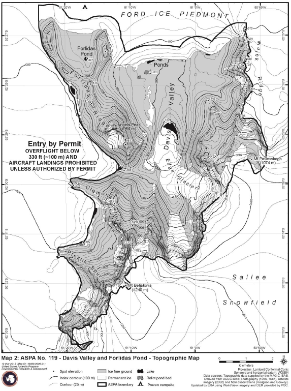
Part 57—Antarctic specially protected area No. 157
1 Name and location
Backdoor Bay, Cape Royds, Ross Island.
77°33′S, 166°10′E.
2 Description
Cape Royds is an ice‑free area at the western extremity of Ross Island, approximately 40 km to the south of Cape Bird and 35 km to the north of Hut Point Peninsula on Ross Island. The ice‑free area is composed of till covered basalt bedrock. The designated Area is located to the northeast of Cape Royds adjacent to Backdoor Bay. It is immediately to the east of ASPA 121, an Adélie penguin colony. The Area is centred on Shackleton’s Nimrod Expedition hut.
The eastern and southern boundary consists of the shoreline of the eastern coast of Cape Royds from an unmarked point in Backdoor Bay (77°33′07.5″S, 166°10′32.6″E) to an unmarked point in Arrival Bay (77°33′15.8″S, 166°10′06.6″E).
The western boundary follows the boundary of ASPA 121 from the coastline at Arrival Bay (77°33′15.8″S, 166°10′06.6″E) 18 m northwest to a signpost at the southern end of the penguin viewing area (77°33′15.2″S, 166°10′05.7″E), a further 74 m to a signpost (77°33′12.9″S, 166°10′01.9″E) on the northern end of the penguin viewing area and a further 42 m to a signpost (77°33′11.8″S, 166°09′59.0″E) east of Pony Lake.
The boundary then extends northwest from the signpost east of Pony Lake (77°33′11.8″S, 166°09′59.0″E) along a gully leading to an unmarked point (77°33′07.5″S, 166°10′12.9″E) adjacent to the New Zealand refuge hut.
The northern boundary extends due east from the New Zealand shelter (from the unmarked point at 77°33′07.5"S, 166°10′12.9″E) to the coastline of Backdoor Bay (77°33′07.5″S, 166°10′32.6″E).
3 Map
7 Part 64 of Schedule 1
Repeal the Part, substitute:
Part 64—Antarctic specially protected area No. 164
1 Name and Location
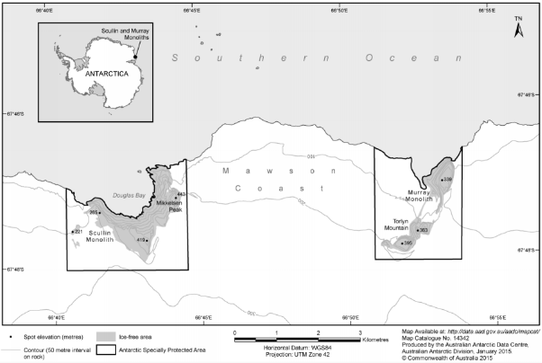
Scullin and Murray Monoliths, Mac.Robertson Land.
67°47′37″S, 66°43′08″E and 67°47′03″S, 66°53′17″E.
2 Description
Scullin Monolith (67°47′37″S, 66°43′08″E) and Murray Monolith (67°47′03″S, 66°53′17″E) are situated on the coast of Mac.Robertson Land some 160 km east of Mawson station. The monoliths are approximately 7 km apart and abut the sea at the edge of the continental ice sheet.
The Scullin and Murray Monoliths ASPA comprises 2 sectors:
(a) Scullin Monolith: the boundary commences at a coordinate on the coastline at 67°46′59″S, 66°40′30″E, then continues in a southerly direction to a coordinate at 67°48′03″S, 66°40′26″E, east to a coordinate at 67°48′06″S, 66°44′33″E, then north to a coordinate on the coast at 67°46′41″S, 66°44′37″E, then west following the coast line at the low tide mark to the coordinate 67°46′59″S, 66°40′30″E.
(b) Murray Monolith: the boundary commences on the coastline at 67°46′36″S, 66°51′01″E, then continues in a southerly direction to 67°48′03″S, 66°50′55″E, extends east to 67°48′05″S, 66°53′51″E, and north to 67°46′38″S, 66°54′00″E, then west following the coast line at the low tide mark to the coordinate 67°46′36″S, 66°51′01″E.
3 Map
8 Clause 2 of Part 67 of Schedule 1
Omit “MacRobertson”, substitute “Mac.Robertson”.
9 Part 2 of Schedule 2
Repeal the Part, substitute:
Part 2—Antarctic specially managed area No. 2
1 Name and location
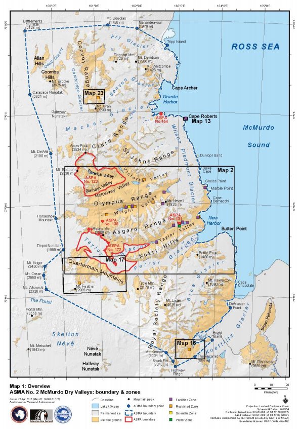
McMurdo Dry Valleys, Southern Victoria Land.
162°30′S, 162°00′E.
2 Description
The McMurdo Dry Valleys are located in southern Victoria Land along the western coast of McMurdo Sound, southern Ross Sea, at approximately 77°30′S, 162°00′E. An area of approximately 17,500 km2 is designated as an Antarctic Specially Managed Area (hereafter referred to as the “Area”) to manage human activities in the region for the protection of scientific, environmental, ecological, historic, aesthetic and wilderness values.
From the northeastern extremity of Tripp Island (76°38.09′S, 162°42.90′E) the boundary extends southward following the coastline at the mean low tide level to DeMaster Point (situated east of Marshall Valley at 78°04.20′S, 164°25.43′E), a distance of approximately 170 km. The boundary thence follows the northwestern margin of the Koettlitz Glacier in a southwesterly direction for approximately 25 km to Walcott Bay and Trough Lake, including within the Area all of the streams and lakes along the glacier margin. The boundary thence follows the approximate southern grounding line of the Koettlitz Glacier margin in Walcott Bay, extending east towards The Bulwark and encompassing all of Trough Lake. The boundary thence continues east following Bulwark Stream for approximately 1.5 km to the northern extremity of The Bulwark. The boundary thence extends 3 km in a straight line northeast to the northwestern coastline of Heald Island, following around the northern coastline to the eastern extremity of the island at 78°15.00′S, 163°57.80′E.
The boundary extends from Heald Island approximately 14.8 km southwest to the summit of The Pyramid (854 m) (78°20.64′S, 163°29.95′E). The boundary thence continues southwest approximately 13.3 km to the foot of Highway Ridge (78°23.97′S, 162°58.57′E), from where it follows up the ridgeline in a northwesterly direction approximately 3.8 km to the summit of Shark Fin (2242 m) (78°22.11′S, 162°54.66′E). The boundary extends from Shark Fin northwest approximately 6.7 km to the summit of Mount Kempe (3004 m) (78°19.35′S, 162°43.18′E). The boundary continues northwest in a straight line from the summit of Mount Kempe approximately 83 km to the summit of Mount Wisneski (2320 m) (77°57.65′S, 159°33.73′E), which is the most southerly peak of the Lashley Mountains.
From Mount Wisneski, the boundary extends northwards for approximately 8.7 km to Mount Crean (2550 m) (77°53.00′S, 159°30.66′E), the highest peak in the Lashley Mountains. The boundary continues 5.6 km northward to the summit of Mount Koger (2450 m) (77°50.05′S, 159°33.09′E), the most northerly peak in the Lashley Mountains.
The boundary thence extends northeast approximately 15.3 km to Depot Nunatak (1980 m) (77°44.88′S, 160°03.19′E), and thence northwest approximately 19.6 km to the western extremity of the ice‑free ground at Horseshoe Mountain (77°34.52′S, 159°53.72′E). The boundary continues north approximately 40 km to the summit of Mount DeWitt (2190 m) (77°13.05′S, 159°50.30′E), thence extends northwest approximately 38.4 km to the summit of Carapace Nunatak (2321 m) (76°53.31′S, 159°23.76′E), and continues a further 39 km north to the summit of Battlements Nunatak (2128 m) (76°32.27′S, 159°21.41′E).
The boundary extends east from Battlements Nunatak approximately 51 km to the summit of Mount Douglas (1750 m) (76°31.25′S, 161°18.64′E), and thence approximately 18 km in a southeasterly direction to the summit of Mount Endeavour (1870 m) (76°32.49′S, 161°59.97′E). The boundary extends southeast from Mount Endeavour approximately 21.3 km to the northeastern extremity of Tripp Island.
3 Map