Schedule 1 Amendment
(section 3)
The National Capital Plan is amended by the following:
- Delete section 4.22 and replace with:
4.22 Special Requirements for National Land
4.22.1 Background
It is in the interest of the National Capital that all National Land achieve a quality of development which reflects Canberra’s significance as the National Capital, and that proposals be assessed in relation to the provisions of the Plan.
4.22.2 Special Requirements
Development, including subdivision and leasing proposals, of all National Land not included in a Designated Area of this Plan, is to conform to Development Control Plans agreed by the National Capital Authority. The exception to this requirement is National Land flanking Northbourne Avenue and outside a Designated Area, which must conform with the requirements at section 4.28 of the Plan.
Development Control Plans are to meet the following requirements:
- Adverse environmental impacts from on-site developments, on adjacent land and development, must be identified and redressed to the extent practicable.
- Adequate provision should be made where appropriate for visitors to sites.
- Functional relationships between uses within and external to the site must be provided for.
- Consistency in the external design and site layout of buildings and landscaping will be sought.
- Satisfactory arrangements must be made for parking accommodation and vehicular access and egress. Traffic impacts of development will be taken into account.
Development proposals for National land, including subdivision, and proposals to lease National Land, will be subject of consideration by the National Capital Authority who will assess proposals to ensure they are not inconsistent with the provisions of the Plan and any relevant Development Control Plan.
2. Delete section 4.23 and replace with:
4.23 Main Avenues
Special Requirements for Main Avenues
It is in the interests of the National Capital that development flanking main avenues in the city is of a type and quality that will enhance the role and status of the city. For the purposes of Special Requirements, the Main Avenues are:
- Northbourne Avenue, between Antill/Mouat Streets and Barry Drive/Cooyong Street
- Adelaide Avenue, outside the Central National Area
- Canberra Avenue, between Hume Circle and the Central National Area
- Brisbane Avenue outside the Central National Area.
These Special Requirements apply to development on land (not included within Designated Areas) adjacent to the Main Avenues identified above.
Special Requirements
Development, except in relation to Northbourne Avenue, is to conform to Development Control Plans (agreed by the National Capital Authority) which seek to secure the integrity of the Main Avenues as Approaches to the Parliamentary Zone and ensure that the setting, buildings and purposes of development enhance that function.
Development Control Plans and development must:
- make provision for national uses, offices for national associations, tourist accommodation and residential development
- seek high standards of building design and finish. External materials should be predominantly light in tone and require little maintenance. Continuous glass façades should be avoided. Criteria for controlling the use of reflective glass should be incorporated.
Development Control Plans must:
- incorporate the following where Main Avenues are the final approaches to the Parliamentary Zone:
- building height controls, to ensure that buildings are at least three storeys in height unless specifically shown otherwise in an agreed Development Control Plan. Plant and equipment must be enclosed and integrated with the form and design of the building.
- Building setbacks to be 10 metres unless specifically shown otherwise in an agreed Development Control Plan. The area in front of the building line is to be landscaped, and exclusive of parking. Minor encroachment of basement parking into this area may be considered where this would not detract from the quality of the landscape treatment and where the parking is located beneath a driveway or other paved area. Minor encroachment by balconies, awnings and porticos may be considered if the materials and design are such that the visual integrity of the building line is retained.
- for Main Avenues with predominantly commercial frontages, provide that buildings adjacent to Main Avenues may be up to four storeys, plus plantrooms, in height.
- For Main Avenues having predominantly landscaped frontages, generally provide for buildings to not exceed the height of the established tree canopy (typically three to four storeys).
- Consider parking, vehicle access, and the traffic impacts of development. Access from and to the Avenues may be permitted where practicable and where traffic safety will not be affected adversely.
For Northbourne Avenue, development must conform to the Special Requirements set out in Section 4.28 City and Gateway Corridor, of the National Capital Plan. The provisions of section 4.28 apply to both Territory Land and National Land sites.
Notes:
Where maximum heights are already exceeded by existing buildings, extensions or rebuilding up to the height of the existing building is permitted.
3. Delete section 4.24 and replace with:
4.24 Approach Routes
It is in the interest of the National Capital that development flanking Approach Routes to the city is of a type and quality complementary to the role and status of the city. Special Requirements apply to the following Approach Routes:
- the Barton and Federal Highways from the ACT borders to their junction with Northbourne Avenue, and extending to include Northbourne Avenue north of Antill/Mouat Streets
- the Monaro Highway from the ACT border through to Morshead Drive
- Canberra Avenue from the ACT border to Hume Circle
- Pialligo Avenue from the ACT border to Morshead Drive
- Fairbairn Avenue.
These Special Requirements apply to development on all land (not included within Designated Areas) which fronts directly onto the Approach Routes AND is not more than 200 metres from their middle lines.
Special Requirements for Approach Routes
Development, except in relation to the Federal Highway, is to conform to Development Control Plans agreed by the National Capital Authority, which seek to enhance the surrounding predominantly rural character and landscape outside the urban areas. As the Approach Routes enter the built up areas, the emphasis will shift to a more formal character.
4. Add a new section 4.28 titled ‘City and Gateway Corridor’ as follows:
4.28 City and Gateway Corridor
Location
These Special Requirements apply to development on all land (not included within Designated Areas):
- adjacent to the Main Avenue of Northbourne Avenue between Antill/Mouat Streets and Cooyong Street/Barry Drive
- which fronts directly onto the Federal Highway from the ACT border to its junction with Northbourne Avenue and extending to include Northbourne Avenue north of Antill/Mouat Streets, AND is not more than 200 metres from its middle line.
Northbourne Avenue and the Federal Highway are defined in Figure 145.
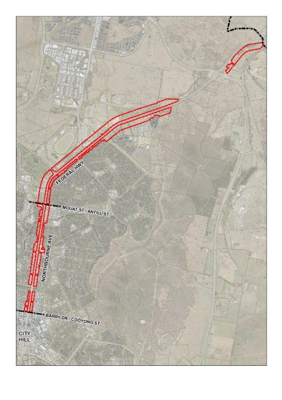
Figure 145: Extent of Northbourne Avenue and the Federal Highway for the purposes of section 4.28
Background
A traveller’s first perception of a city’s character is gained upon approach and arrival. When arriving in Canberra it is important that the traveller is aware of the special symbolic and functional significance of the National Capital. The Federal Highway is a principal northern approach route to the National Capital, transitioning into Northbourne Avenue.
Design and development of the corridor should heighten the traveller’s first perception of the National Capital, and enhance recognition of the special symbolic and functional significance of the National Capital. Expectations should be built up by progressively formalising the design character as the corridor approaches the city centre.
As the final approach to the city centre and Central National Area, the design of Northbourne Avenue and development flanking the avenue, should be of a standard that places it alongside other significant urban boulevards both nationally and internationally. Northbourne Avenue should be distinguished by a formality that is uniquely Australian.
Objectives for City and Gateway Corridor
- Create an identifiable approach, which increases in formality as it gets closer to the city centre and Central National Area, and which clearly signifies the symbolic and functional roles of the National Capital.
- Encourage a design-led approach to development with a focus on high quality interfaces between built form and urban landscapes.
- Ensure that buildings and landscape exhibit design excellence in recognition of the corridor’s role as a key northern approach route to the city.
- Create a landscape setting, including deep root plantings, to provide amenity, assist with climate control, and create comfort for pedestrians.
- Encourage sustainability as a base requirement for all new buildings.
Land use
Land use for all sites, including both National Land and Territory Land, must be in accordance with the relevant zone identified under the Territory Plan.
Detailed conditions of planning, design and development
Building envelope
Building heights
Northbourne Avenue
Buildings adjacent to Northbourne Avenue are to be a maximum of 25 metres in height above datum ground level measured from the front boundary adjoining Northbourne Avenue. Where a building includes a residential apartment that incorporates a two story or mezzanine unit, (above ground level), building height may be increased to 27.5 metres.
Buildings at the intersection of Northbourne Avenue with Antill/Mouat Streets are to be a maximum of 32 metres above ground level.
Where building height limits are 25 metres, 27.5 metres or 32 metres, minor building elements for roof top plant, are permitted where they do not increase the building height as it presents to public street frontages. No habitable room or occupiable room (being rooms where people may be present in the normal use of a building) is permitted above maximum prescribed height limits.
Where maximum permitted building heights are already exceeded by existing buildings, extensions or rebuilding up to the height of the existing building is permitted, provided all other planning and design requirements are met.
Development at the intersection of Northbourne Avenue with Macarthur/Wakefield Avenues must accord with Figure 146. Buildings up to RL617 are permitted at the locations identified in this figure. No building elements are permitted above RL617.
Mid-block links on sites at the intersection of Northbourne Avenue with Macarthur/Wakefield Avenues are to be provided through each site connecting rear streets to Northbourne Avenue. The exact locations of mid-blocks links may be determined by proponents. The mid-block links must be a minimum of 10 metres in width, and remain publicly accessible at all times.
Federal Highway
Maximum permitted building heights adjacent to the Federal Highway are:
- Between Antill/Mouat Streets and Panton Street/Barton Highway – 18 metres (refer Figure 147).
- Between Panton Street/Barton Highway and Flemington Road/Phillip Avenue – 12 metres (refer Figure 147).
- Between Flemington Road/Phillip Avenue and the ACT/NSW border – 8.5 metres.
Any minor building elements, including roof top plant, should not increase the building height as it presents to public street frontages. No habitable room is permitted above maximum prescribed height limits.
Where maximum permitted building heights are already exceeded by existing buildings, extensions or rebuilding up to the height of the existing building is permitted, provided all other planning and design requirements are met.
Maximum building height for development shall:
- be measured from the level of the block boundary closest and directly adjacent the Federal Highway
- be measured from a line perpendicular from the road reservation. The height of the road reservation boundary may be normalised, taking the measure five metres either side of the culvert, where it passes over culverts and other localised earthworks.
The extent of developable land to the west of the Federal Highway may be adjusted where public access via a shared path and naturalisation of Sullivans Creek is included as part of a development proposal.
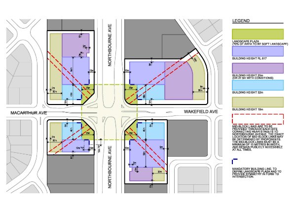
Figure 146: Development requirements, including permitted building heights, at the intersection of Northbourne Avenue with Macarthur/Wakefield Avenues
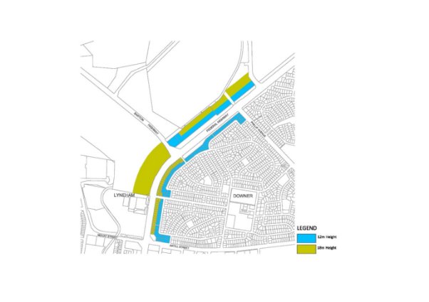
Figure 147: Permitted building heights from Antill/Mouat Streets to Phillip Avenue and Flemington Road
Building setbacks
Northbourne Avenue
Buildings must be set back a minimum of 10 metres from the property boundary adjacent to Northbourne Avenue.
Basements and balconies must not extend into the setback area adjacent to Northbourne Avenue. Minor encroachment such as awnings or architectural details may be considered if the materials and design are such that the visual integrity of the building line is retained.
Service areas and facilities such as loading zones, water/gas metres, water tanks, waste enclosures, and basement ramps are not permitted forward of the building line on the Northbourne Avenue frontage.
A composition of soft landscaping must be provided between the building line and block boundaries to Northbourne Avenue and major cross streets. Hard surfacing, other than for pathways and driveways, should be avoided. Parking spaces and porte cochere vehicle drop off areas are not permitted.
Rear and side setbacks must be in accordance with the relevant provisions of the Territory Plan.
Federal Highway
Minimum required building setbacks to the Federal Highway are to be in accordance with Figures 148 and 149, and as follows:
- Where a building is 8.5 metres or less in height, setbacks are to be in accordance with the Territory Plan.
- Between Antill/Mouat Streets and the Barton Highway/Panton Street –on the eastern side or the road, 6 metres from the property boundary closest to the Federal Highway; on the western side of the road, 24 metres from the property boundary closest to the Federal Highway .
- Between the Barton Highway/Panton Street and Flemington Road/Phillip Avenue – 70 metres from the centreline of the Federal Highway.
- On the northern side of the Federal Highway between Flemington Road and the ACT/NSW border – 30 metres from the Federal Highway road reservation.
- On the southern side of the Federal Highway between Phillip Avenue and Stirling Avenue – 6 metres from the Federal Highway road reservation.
- On the southern side of the Federal Highway between Stirling Avenue and the eastern boundary of Block 18 Section 75 Watson – 15 metres from the Federal Highway road reservation.
- On the southern side of the Federal Highway between the eastern boundary of Block 18 Section 75 Watson and the ACT/NSW border – 30 metres from the Federal Highway road reservation.
Service areas and facilities such as loading zones, water/gas metres, water tanks, waste enclosures, and basement ramps are not permitted forward of the building line on the Federal Highway frontage where associated with multi-unit housing proposals.
A composition of soft landscaping must be provided between the building line and block boundaries to Northbourne Avenue and major cross streets. Hard surfacing, other than for pathways and driveways, should be avoided. Parking spaces and porte cochere vehicle drop off areas are not permitted where associated with multi-unit housing proposals.
All other setbacks must be in accordance with the relevant provisions of the Territory Plan.
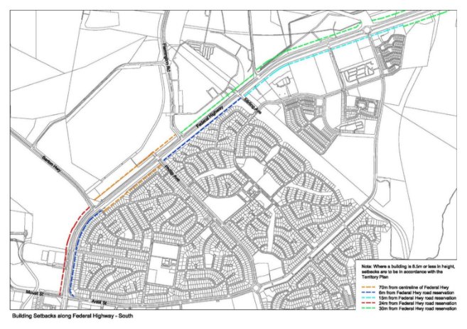
Figure 148: Required building setbacks for Federal Highway (south)
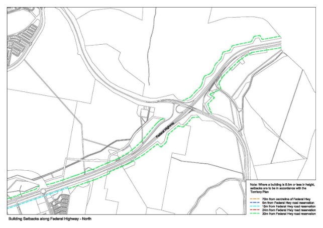
Figure 149: Required building setback for Federal Highway (north)
Building separation
Minimum separation distances for buildings are:
Building height | Between windows in habitable rooms/unscreened balconies | Between windows in habitable and non-habitable rooms | Between non-habitable rooms |
Up to 4 storeys | 12m | 9m | 6m |
5 to 8 storeys | 18m | 12m | 9m |
9 storeys and above | 24m | 18m | 12m |
Where blocks have a front boundary to Northbourne Avenue less than 35 metres wide, building separation distances may be reduced provided all of the following are achieved:
- reasonable levels of visual and acoustic privacy
- suitable areas for soft landscaping and deep root planting.
Where a building is located on a block abutting a lower density zone, building setbacks to the relevant boundary of sites zoned for lower density should be increased by three metres.
Greater building separation may be required by the Territory planning authority where increased building separation may achieve better amenity outcomes.
Building separation is measured from the outer face of external walls or outer edge of balconies as relevant. When applying building separation distances to buildings on adjoining sites, apply half the minimum separation distance measured to the boundary where possible.
Note:
Minimum building separation distances apply to buildings within development sites, between residential and non-residential uses, and to buildings on adjacent sites with a shared boundary.
Length of buildings
Long buildings that limit permeability, block views, and disrupt a pedestrian-scaled neighbourhood system should be avoided.
Buildings are limited to a maximum length of 55 metres. Longer buildings may be permitted at lower building levels where strong design justifications is provided, such as provision of continuous, active street frontages. Where this is the case, pedestrian mid-block links between 5 and 10 metres wide must be provided at least once every 55 metres through the built form. Longer buildings may also be permitted at the intersection of Northbourne Avenue with Macarthur/Wakefield Avenues, where the buildings run perpendicular to the Northbourne Avenue.
Building design and architecture
Building façades
Façade design is to include the use of articulation and modulation to clearly express the organisational or structural grid of the buildings, and to break up the mass of longer buildings.
A balance of light and shadow on the façade is to be created throughout the day through the use of balconies, deeper window reveals, integrated shading, rebates, and expression of structural elements.
Façade materials must be of high quality. A use of robust, low maintenance materials in the higher parts of a building, and natural, tactile and visually interesting materials at the lower levels should be used. Corrugated metal building materials as wall cladding is not permitted for those parts of a building visible from Northbourne Avenue or the Federal Highway.
Building entries must be clearly defined and identifiable from the street.
Private open space
Private open space must be incorporated into the design of all residential dwellings. The following provisions apply to proposals for multi-unit housing or where multi-unit housing is a component of the development.
Minimum balcony areas for dwellings wholly on an upper floor level are:
- Studio apartments – 4m² (no minimum dimension)
- 1 bedroom apartments – 8m² with a minimum dimension of 2 metres
- 2 bedroom apartments – 10m² with a minimum dimension of 2 metres
- 3+ bedroom apartments – 12m² with a minimum dimension of 2 metres.
For dwellings wholly or partially at ground level or on a podium or similar structure, a private open space must be provided of the following minimum size:
- Studio apartments – 18m² with a minimum dimension of 4 metres
- 1 bedroom apartments – 24m² with a minimum dimension of 4 metres
- 2 bedroom apartments – 24m² with a minimum dimension of 4 metres
- 3+ bedroom apartments – 36m² with a minimum dimension of 6 metres
Storage units, or plant and equipment (including air conditioning plant) are not permitted on balconies. Clothes drying facilities may be provided where they are screened from view of streets and other public spaces.
Balconies must be designed to allow views and passive surveillance of the street while maintaining visual privacy and allowing for a range of uses on the balcony. Balconies must be designed in accordance with the following:
- Balustrades to balconies to 12 metres above ground floor level must be solid.
- Full width and full height glass balustrades are not permitted below 20 metres above datum ground level.
- balustrades 12- 20 metres above ground floor level must be solid.
To maintain visual and acoustic privacy, partitions between adjoining balconies must be constructed of solid materials designed to have low noise penetration properties. Glazing or other light weight materials are not permitted as a partition between balconies. Operable screens, shutters, hoods and pergolas are encouraged to control sunlight and wind.
Private open spaces must not extend more than four metres into the building setback area, and must not occupy more than 40 per cent of a building frontage.
Roof design
The design of the roof should be integrated into the architecture of the building, use high quality materials, and provide a positive addition to the streetscape. Continuous, horizontal parapets extending the full length of the building are not permitted.
Service elements and roof top plant must be integrated into roof design and not be visible from public areas, including streets.
The design of roofs and parapets should be articulated and express the layout and structure of the building.
Roof design should incorporate sustainability features to maximise solar access to internal building spaces during winter and provide shade during summer.
Communal open space areas and rooftop gardens may be considered. Fully enclosed structures on roof tops are not permitted. Structures such as pergolas must not occupy more than 10 per cent of the total roof area and must be set back a minimum of three metres from the façade below.
For sites between Panton Street/Barton Highway and ACT/NSW border, flat roofs or facades with wide fascias giving the impression of a flat roof are not permitted.
Ceiling heights
Ceiling heights should promote natural ventilation and daylight access to internal building spaces, and contribute to the flexibility of building use over the life of the building.
Northbourne Avenue
Minimum floor to ceiling heights within buildings on sites adjacent to Northbourne Avenue shall be as follows:
Ground floor directly facing Northbourne Avenue (uses other than residential) – 6.0 metres (mezzanine permitted over 30% of ground floor)
Ground floor (residential) – 3.3 metres
Ground floor (other uses, including commercial/office use) – 3.6 metres
Residential (general) –
- 2.7 metres floor-to-ceiling minimum for all habitable rooms (with the exception of kitchens, which are permitted to have a minimum 2.4 metre floor-to-ceiling height), and 2.4 metres for all non-habitable rooms.
- For two-storey units, 2.4 metres minimum for second storey if 50 percent or more of the apartment has 2.7 metre minimum ceiling heights.
- For two-storey units with a two-storey volume living space, 2.4 metre minimum ceiling heights.
- Attic spaces are permitted, with a 1.8 metre minimum wall height at edge of room with a 30 degree minimum ceiling slope.
Federal Highway
Minimum floor to ceiling heights within buildings on sites fronting the Federal Highway shall be as follows:
Ground floor (all uses except residential) – 3.6 metres
Residential (general) –
- 2.7 metres floor-to-ceiling minimum for all habitable rooms (with the exception of kitchens, which are permitted to have a minimum 2.4 metre floor-to-ceiling height), and 2.4 metres for all non-habitable rooms.
- For two-storey units, 2.4 metres minimum for second storey if 50 percent or more of the apartment has 2.7 metre minimum ceiling heights.
- For two-storey units with a two-storey void living space, 2.4 metre minimum ceiling heights.
Attic spaces are permitted, with a 1.8 metre minimum wall height at edge of room with a 30 degree minimum ceiling slope.
Residential apartment design
The layout of rooms within an apartment must be functional, well organised and provide a high standard of amenity. Dwellings are required to have the following minimum internal areas:
Dwelling type | Minimum internal area |
Studio | 40m² |
1 bedroom | 50m² |
2 bedroom | 70m² |
3 bedroom | 100m² |
The minimum internal areas include only one bathroom. Additional bathrooms increase the minimum internal area by 5m² each. Additional bedrooms increase the minimum internal area by 12m² each.
Common circulation spaces
The maximum number of dwellings off a circulation core on a single level must be no more than nine. A high level of amenity for common lobbies and corridors should be demonstrated through the provision of access to ample daylight and natural ventilation, common areas for seating and gathering, and generous corridors with greater than minimum ceiling heights.
Corridors longer than 12 metres from the lift core should be articulated, for example by a series of foyer areas with windows and spaces for seating, and wider areas at apartment entry doors and varied ceiling heights.
Primary living room or bedroom windows must not open directly onto common circulation spaces.
Environmental performance
Energy efficiency
Development should incorporate passive solar design to optimise heat storage in winter and reduce heat transfer in summer. Potential design options include the use of smart glass or other technologies (particularly on north and west elevations), maximising thermal mass in the floors and walls of north facing rooms, overhangs and shading devices such as awnings, blinds and screens.
Operable screening such as louvres, sliding, folding or retractable elements should be designed to provide shade and protection from natural elements. Operable screening elements must be integrated with building design.
Building design must incorporate shading and glare control, particularly to manage sun penetration in warmer months. Design features could include:
- balconies or sun shading that extend far enough to shade summer sun, but allow winter sun to penetrate living areas
- shading devices such as eaves, awnings, balconies, pergolas, external louvres
- horizontal shading to north facing window
- vertical shading to east and particularly west facing windows
- operable shading to allow adjustment
Residential use
Developments with residential components must provide a variety of apartment designs such as dual aspect apartments, shallow apartment layouts, two storey and mezzanine level apartments. Building design must achieve the following:
- Living rooms and private open spaces of at least 70% of apartments in a building must receive a minimum of 3 hours direct sunlight between 9am and 3pm on the winter solstice (21 June).
- A maximum of 15% of apartments in a building receive no direct sunlight between 9am and 3pm on the winter solstice (21 June).
All habitable rooms must have an operable window in an external wall with a total minimum glass area of not less than 15% of the floor area of the room. Courtyards, skylights and high level windows (with sills above 1700mm) may only be used as a secondary light source in habitable rooms.
‘Snorkel’ arrangements are not permitted as a mechanism to provide natural light or ventilation.
All habitable rooms should be naturally ventilated. Building design should demonstrate consideration of the building’s orientation to maximise capture and use of prevailing breezes, depths of habitable rooms, openable windows and the use of awnings and louvres to funnel breezes. Light wells must not be the primary air source for habitable rooms.
The number of apartments with natural cross ventilation is maximised to create a comfortable indoor environment for residents. At least 60% of apartments should be naturally cross ventilated in the first nine storeys of a building.
Street frontage
Finished ground floor levels set below the adjacent finished public footpath pavement levels on Northbourne Avenue and the Federal Highway are not permitted. The fall from the building entrance to the kerb must generally be less than 2%. Where datum ground level of a site is below the adjacent footpath level, ground floor levels must not be set below datum ground level.
Where residential use is proposed at ground floor level, a vertical separation up to 450mm above the adjoining finished ground level within the site or adjacent verge is permitted to assist in providing privacy.
Where commercial uses are located on ground floors of buildings, buildings must be designed to ensure a direct connection for building users to the adjacent verge and setback area to ensure street continuity.
Service areas must be integrated within the building design to avoid impacting the public domain. Basement car parks and ramps to basement car parks must not be visible from the street.
Landscape
Landscape character
Landscape design for development along the Federal Highway and Northbourne Avenue corridor is a fundamental character feature of the gateway into the city centre. It should unite development with the existing landscape character of Canberra, soften the impact of larger building form and provide visual relief to the urban condition, consistent with Canberra’s status as the bush capital.
New plantings must not diminish the heritage significance of places and objects on the ACT Heritage Register, or affect public appreciation of the qualities of these places. Development must provide substantial tree and understorey planting, supported by functional, safe and attractive areas of open space. Development must continue to deliver Canberra as a city in a landscape.
The spaces between buildings must be landscaped to a high quality and promote green links between the private and public domain.
Landscape spaces must be designed to clearly differentiate between areas intended for public and private use, maximising the functionality of both. Landscaped areas must be designed for maximise user comfort and safety.
Planting within front setback areas should consist primarily of trees, as opposed to shrubs or other low vegetation. A minimum of 30 per cent of plantings within setback areas should be capable of achieving at least 15 metres in height.
All developments must renew the adjacent road verge in accordance with the principles outlined in this section.
Mature trees should be retained to the maximum extent practicable and integrated into landscape design. Where existing trees must be removed, they must be compensated for by planting elsewhere on site.
Landscape design must enhance environmental performance and microclimate. This could be achieved by planting appropriate trees near eastern and western façades for shade, planting a mix of evergreen and deciduous trees to provide shade in summer and allow sunlight access in winter, and incorporating green walls and roofs into building design.
All Landscaping within development sites must complement the landscape design themes evident in the corridor:
ACT/NSW Border to Stirling Avenue
Development must meet the requirements for the identified landscape realms and themes for the Federal Highway at section 4.15.4 of the National Capital Plan.
South of Stirling Avenue
The scale of landscape must respond primarily to the height of adjacent buildings, ensuring the landscape is the dominant element. Built form should be screened through the use of plant material.
Between Stirling Avenue and Antill/Mouat Street, an ‘informal park boulevard’ should be established. This ‘informal park boulevard’ should primarily comprise tree species endemic to the Canberra region and capable of reaching 20 metres in height. Species such as Eucalyptus melliodora, Eucalyptus microcarpa and Eucalyptus polyanthemos are considered suitable. Spacing between trees should be no greater than 15 metre centres.
South of Antill/Mouat Streets
A ‘formal landscape avenue’ containing consistent street tree planting within the verge and extending into the front setback area.
Landscape design must reflect the formality of Northbourne Avenue, and include rows of trees, regulatory in planting, and formal hedging.
Landscape design and planting should respond to Canberra’s blend of endemic and introduced species, reinforcing the ‘bush capital’. Plant species should be chosen for their effectiveness and adaptability to Canberra’s climate to reduce heat islands and to maximise shade.
Sullivans Creek
Development adjacent to Sullivans Creek must assist in enhancing Sullivans Creek as a multi-functional creek corridor that enhances environmental values, improves ecological connectivity and wildlife, and integrates Aboriginal heritage and culture into its design. Proposals must demonstrate how the following objectives are met:
- increased active travel opportunities and links to other destinations within the open space network
- public access through the site via active travel routes
- improvement in safety and surveillance
- acknowledgement of the cultural rights of Aboriginal and Torres Strait Islander people.
The naturalisation of Sullivans Creek must be explored by proponents as a way of improving stormwater management of the waterway, and enhancing ecological values.
Deep soil zones
A planting zone, no less than five metres wide, should be provided within the front setback areas and be retained for deep soil planting.
Front setback areas should be retained for deep soil planting.
A minimum deep soil zone dimension of five metres should be applied where located on site.
Deep soil zones should be located to retain existing significant trees and to allow for the development of healthy root systems, providing anchorage and stability for mature trees. Landscape and building design must demonstrate:
- the consolidation of basement and sub-basement car parks beneath building footprints
- adequate clearance around trees to ensure long term health
- co-location with other deep soil areas on adjacent sites to create larger contiguous areas of deep soil.
Access and parking
Northbourne Avenue
Vehicle access, including verge crossings and driveways, to sites shall be located and designed to ensure pedestrian and cycle priority. The design of vehicle access arrangements to sites fronting Northbourne Avenue should ensure that pedestrian and cyclist desire lines and paths are maximised, the width of the vehicle access way is minimised and its materials integrate with landscaping within the verge and setback.
Where possible, sites should share vehicle access via a shared space with adjoining properties that extends from Northbourne Avenue to the rear street frontage. The space should be designed to prioritise pedestrian and cyclist movement, contain high quality public realm treatments, including tree planting, footpaths and lighting that add visual interest.
Where a site cannot accommodate shared access arrangements, a maximum of one crossover per block is permitted. The crossover and driveway should be located along or close to the side boundaries rather than towards the centre of the block.
To minimise potential conflicts, pedestrian and cyclist, and vehicle access to sites should be clearly separated and distinguishable. This may include changes in surface materials, level changes, or the use of landscaping for separation.
Car parking should be provided in basements. Podium and multi-level car parking structures fronting Northbourne Avenue are not permitted. On-grade parking is discouraged and will only be permitted if the following criteria are met:
- parking is located to the rear of the site away from Northbourne Avenue and major cross streets
- cars are screened from view to the maximum extent possible of streets, buildings, communal and private open space areas
- parking is incorporated into the landscape design of the site, by extending planting and materials into car parking space
- light coloured paving materials or permeable paving systems are used and shade trees are planted between every 4-5 parking spaces to reduce increased surface temperatures from large areas of paving.
Car park entries should be located away from Northbourne Avenue.
A traffic and parking assessment should accompany development proposals for any site for consideration by the relevant authority.
Federal Highway
The visual impact of large car parking areas must be minimised through adequate screening and landscape treatment that appropriately considers view lines and safety. Podium and multi-level car parking structures fronting the Federal Highway are not permitted.
Careful consideration should be given to the access, internal circulation and parking of service and heavy goods vehicles within the area.
A traffic and parking assessment should accompany development proposals for any site, for consideration by the relevant authority.
Lighting
All outdoor lighting, including security and car park lighting, must be designed and sited to minimise light pollution. All outdoor lighting (including lighting fixed to structures) must use full cut-off light fittings. Any uplighting of buildings should be carefully designed to keep night time overspill and glare to a minimum.
Specialty lighting should be used to highlight any ACT border marker.
Signage
Northbourne Avenue
Careful consideration should be given to the integration of signs with building design and landscaping to ensure they do not detract from the Northbourne Avenue frontage. Any signage not affixed to a building must be within a landscape setting.
Signage across a site should be designed in accordance with a cohesive and coordinated theme, and respond to the scale, proportion and detailing of the development.
To minimise visual clutter, individual commercial tenancies should have no more than one sign fronting Northbourne Avenue. For residential development, a single wall sign is permitted, of no more than 10% in size of the façade on which it is located. Larger developments may include legible and discrete way finding signage.
Permitted road signs are those that could reasonably be expected along a main thoroughfare, such as directional signage and street signs, and that are required by relevant traffic authorities. No commercial advertising is permitted on road signs.
Changeable message signs, animated or flashing signs, and third party advertising signs are not permitted on building facades or roofs visible from, or within setback areas to, Northbourne Avenue.
Federal Highway
Careful consideration should be given to the integration of signs with building design and landscaping to ensure they do not detract from the Federal Highway frontage. Any signage not affixed to a building must be within a landscape setting.
Signage across a site should be designed in accordance with a cohesive and coordinated theme, and respond to the scale, proportion and detailing of the development.
All signs on buildings must be below the eaves or parapet capping of a building. A maximum of one wall sign visible from the Federal Highway road frontage will be permitted per building. The maximum permitted size of a wall sign is four square metres, or 10% of all space, whichever is the lesser.
Permitted road signs are those that could reasonably be expected along a main thoroughfare, such as directional signage and street signs, and that are required by relevant traffic authorities. No commercial advertising is permitted on road signs.
A single free standing pylon/column sign is permitted for the EPIC service station site (Block 4 Section 72 Lyneham and Block 429 Gunaghlin). No other free standing signage is permitted.
Temporary freestanding signage will be permitted where associated with events at EPIC. Such signage must be consistent with Territory signage policies or the Signs General Code of the National Capital Plan, depending on location.
Fencing
Fencing along site frontages to Northbourne Avenue, or within the setback area to Northbourne Avenue, is not permitted.
Private open space for ground floor dwellings fronting Northbourne Avenue may be enclosed by courtyard walls. Courtyard walls to private open space fronting Northbourne Avenue must be:
- not higher than 1.8 metres above datum ground level, with solid components not higher than 1 metre
- constructed of high quality materials (pre-coloured metal, unfinished timber panels, chain-link, barbed or razor wire is not permitted)
- integrated with landscaping.
For sites fronting the Federal Highway, fences are to be designed in a manner that is integral with the landscape design using high quality materials. The use of pre-coloured metal, chain-link, barbed or razor wire is not permitted where visible from the Approach Route.
All fencing to site boundaries must not be bulky or obtrusive.
Design Review Panel
Design concepts for any development or redevelopment proposals must be considered by the National Capital Design Review Panel (NCDRP) prior to a development application being lodged with the National Capital Authority where the proposal is on National Land, or the Territory planning authority where the proposal is on Territory Land. Proposals involving only extensions to existing buildings and/or refurbishment proposals involving substantial external works will be considered by the NCA and Territory planning authority on a case-by-case as to whether they are subject to the design review process. The exception to these requirements are development proposals relating to single dwelling housing and secondary residences, which are not subject to the design review process.
Each item raised in the advice provided by the NCDRP must be addressed by a proponent and subsequently be considered during the assessment of any proposal by either the National Capital Authority or Territory planning authority.
Definitions
For the purposes of section 4.28, the definitions of the Territory Plan apply.
5. Add the following definitions, in alphabetical order, to Appendix B – General definitions:
Datum ground level
Means the surface ground level as determined in a field survey authorised by a registered surveyor:
- at the time of Operational Acceptance for subdivision; or
- if a. is not available, provided no new earthworks have occurred; or
- at the date of grant of the lease of the block;
whichever is the earliest.
Where a., b. or c. is not available, datum ground level is the best estimate of the surface ground level determined in a field survey considering the levels of the immediate surrounding area and authorised by a registered surveyor.
Deep soil zone
Means an area of soil within a development that is unimpeded by buildings or structures above and below ground, and which has sufficient dimensions to allow for the growth of healthy trees. Deep soil zones exclude basement car parks, services, swimming pools, tennis courts and impervious surfaces including car parks, driveways, podium and roof areas.
Habitable (including habitable room)
Means a room within a dwelling capable of being lawfully used for the normal domestic activities of living, sleeping, cooking or eating, and –
- includes a bedroom, study, living room, family room, kitchen, dining room, home theatre, rumpus room; but
- does not include a bathroom, laundry, utility room, hallway, garage or other spaces of a specialised nature occupied either frequently or for extended periods.
6. Amend the National Capital Plan to recognise consequential changes to page numbers, figure numbers and text references, and contents page.
