1 Name
This instrument is the Native Title (Recognition as Representative Body – North Queensland Land Council) Instrument 2021.
2 Commencement
(1) Each provision of this instrument specified in column 1 of the table commences, or is taken to have commenced, in accordance with column 2 of the table. Any other statement in column 2 has effect according to its terms.
Commencement information |
Column 1 | Column 2 | Column 3 |
Provisions | Commencement | Date/Details |
1. The whole of this instrument | 1 July 2021 | |
Note: This table relates only to the provisions of this instrument as originally made. It will not be amended to deal with any later amendments of this instrument.
(2) Any information in column 3 of the table is not part of this instrument. Information may be inserted in this column, or information in it may be edited, in any published version of this instrument.
3 Authority
This instrument is made under subsection 203AD(1) of the Native Title Act 1993.
4 Definitions
In this instrument:
Act means the Native Title Act 1993.
Representative Body means a representative Aboriginal/Torres Strait Islander body recognised under section 203AD of the Act.
North Queensland Land Council means the North Queensland Land Council Native Title Representative Body Aboriginal Corporation (ICN 1996) as registered under the Corporations (Aboriginal and Torres Strait Islander) Act 2006.
5 Schedules
Each instrument that is specified in a Schedule to this instrument is amended or repealed as set out in the applicable items in the Schedule concerned, and any other item in a Schedule to this instrument has effect according to its terms.
6 Recognised Representative Aboriginal/Torres Strait Islander Body
For subsection 203AD(1) of the Act, the North Queensland Land Council is recognised as the Representative Body for the area described in Schedule 1.
7 Period of recognition
For subsection 203AD(2) of the Act, this recognition as a Representative Body takes effect on 1 July 2021 and ceases to have effect at the end of 30 June 2023.
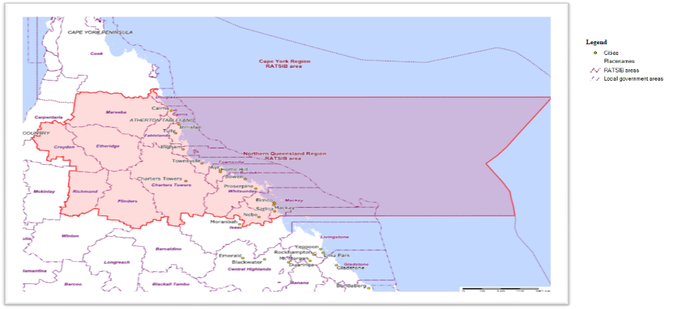
Schedule 1—Description of area (Northern Queensland)
The area is the area of land and water bounded by a line commencing at the intersection of a southern boundary of the Mackay Regional Council (Local Government Area) and the coastline of mainland Australia and extending generally westerly and generally south westerly along southern boundary of that regional council to its intersection with the eastern boundary of the former Nebo Shire Council (Local Government Area); then generally southerly and generally westerly along eastern and southern boundaries of that former shire council to intersect a southern boundary of the Whitsunday Regional Council, a point on the centreline of the Suttor River; then generally westerly along southern boundaries of that regional council to its intersection with an eastern boundary of the Charters Towers Regional Council, then generally south westerly, generally westerly, generally southerly, again generally westerly and generally northerly along eastern, southern and western boundaries of that regional council to the easternmost south eastern corner of the Flinders Shire Council; then generally westerly along southern boundaries of that shire council to its intersection with an eastern boundary of the Richmond Shire Council; then generally south westerly, generally westerly, generally northerly and easterly along southern, western, and northern boundaries of that shire council to the southernmost south western corner of the Croydon Shire Council; then generally north westerly, generally northerly and generally easterly along southern, western and northern boundaries of that shire council to its intersection with a western boundary of the Etheridge Shire Council; then north easterly along the boundary of that shire council to its intersection with a western boundary of the Tablelands Regional Council; then generally northerly and generally easterly along western and northern boundaries of that regional council to its intersection with a western boundary of the Cairns Regional Council; then generally northerly and generally easterly along western and northern boundaries of that regional council to a corner at Longitude 145.255114° East, a point on the McDowall Mountain Range; then generally south westerly, generally southerly and north easterly along that mountain Range passing through the following coordinate points:
Longitude East | Latitude South |
145.253696 | 15.935481 |
145.263160 | 15.955775 |
145.252034 | 15.963983 |
145.216218 | 15.974830 |
145.168604 | 15.981903 |
145.178724 | 15.996054 |
145.177476 | 16.015895 |
145.163457 | 16.030390 |
145.167809 | 16.038407 |
145.162542 | 16.050854 |
145.163259 | 16.052878 |
145.168505 | 16.050151 |
Then easterly to the source of Adastra Creek; then generally southerly along the centreline of that creek to the centreline of the Daintree River; then generally south easterly and generally easterly along the centreline of that river to its intersection with the coastline of mainland Australia; then south easterly to Longitude 145.466927° East, Latitude 16.304254° South; then easterly passing through the southernmost point of the Mean High Water Mark of Snapper Island to intersect the outer limit of the Exclusive Economic Zone of Australia at Latitude 16.304254° South; then generally south westerly and generally south easterly along eastern boundaries of that economic zone to Latitude 21.631045° South; then westerly back to the commencement point.
Data Reference and source
- Regional Council and Shire Council areas (Local Government Areas) sourced from the Queensland Department of Natural Resources and Water 15 March 2008.
- Former Nebo Shire Council boundary as at 1991.
- Rivers / Creeks based on Cadastral data where available and sourced from the Queensland Department of Natural Resources and Water September 2007 or 250K Topographic vector data is © Commonwealth of Australia (Geoscience Australia) 2003.
- Exclusive Economic Zone as defined in the Seas and Submerged Lands Act 1973.
Reference datum
Geographical coordinates have been provided by the NNTT Geospatial Services and are referenced to the Geocentric Datum of Australia 1994 (GDA94), in decimal degrees and are based on the spatial reference data acquired from the various custodians at the time.
Prepared by Geospatial Services, National Native Title Tribunal (23 June 2008)