Crimes (Major Airports—Cairns Airport) Determination 2022
I, Karen Andrews, Minister for Home Affairs, make the following determination.
Dated 22 February 2022
Karen Andrews
Minister for Home Affairs
Crimes (Major Airports—Cairns Airport) Determination 2022
I, Karen Andrews, Minister for Home Affairs, make the following determination.
Dated 22 February 2022
Karen Andrews
Minister for Home Affairs
Contents
1 Name
2 Commencement
3 Authority
4 Major airport—Cairns Airport
Schedule 1—Description of land in relation to Cairns Airport
1 Name
This instrument is the Crimes (Major Airports—Cairns Airport) Determination 2022.
(1) Each provision of this instrument specified in column 1 of the table commences, or is taken to have commenced, in accordance with column 2 of the table. Any other statement in column 2 has effect according to its terms.
Commencement information | ||
Column 1 | Column 2 | Column 3 |
Provisions | Commencement | Date/Details |
1. The whole of this instrument | The day after this instrument is registered. | 1 March 2022 |
Note: This table relates only to the provisions of this instrument as originally made. It will not be amended to deal with any later amendments of this instrument.
(2) Any information in column 3 of the table is not part of this instrument. Information may be inserted in this column, or information in it may be edited, in any published version of this instrument.
This instrument is made under subsection 3UO(1) of the Crimes Act 1914.
4 Major airport—Cairns Airport
(1) Cairns Airport is determined as an airport for the purposes of paragraph (m) of the definition of major airport in subsection 3UM(1) of the Crimes Act 1914.
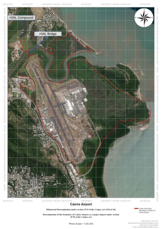
(2) For the purposes of paragraph 3UM(2)(b) of the Crimes Act 1914, the land in relation to Cairns Airport is described as follows by the aerial photographic map in Schedule 1:
(a) the land, including land beneath an area of water, within the boundary of each area indicated by a continuous red line on the map, as far as the edge of the land indicated by the outer edge of the line (including, for example, the land on which the HIAL (High Intensity Approach Lighting) compound identified by the map is situated);
(b) the land over which the HIAL bridge identified by the map is situated, including the riverbed underneath the bridge and the land on or under the approaches to the bridge, and consisting of the relevant land indicated by red lines on the map.
Note 1: The HIAL bridge identified by the map spans the Barron River.
Note 2: The land described in this subsection includes any building, structure, installation or equipment situated on the land (see paragraph 3UM(2)(c) of the Crimes Act 1914). For example, this includes the HIAL compound mentioned in paragraph (a) and the HIAL bridge mentioned in paragraph (b).
Schedule 1—Description of land in relation to Cairns Airport
Note: See section 4.