1 Name
This instrument is the Great Barrier Reef Marine Park Amendment (No-anchoring Areas) Regulations 2024.
2 Commencement
(1) Each provision of this instrument specified in column 1 of the table commences, or is taken to have commenced, in accordance with column 2 of the table. Any other statement in column 2 has effect according to its terms.
Commencement information |
Column 1 | Column 2 | Column 3 |
Provisions | Commencement | Date/Details |
1. The whole of this instrument | The day after this instrument is registered. | 31 August 2024 |
Note: This table relates only to the provisions of this instrument as originally made. It will not be amended to deal with any later amendments of this instrument.
(2) Any information in column 3 of the table is not part of this instrument. Information may be inserted in this column, or information in it may be edited, in any published version of this instrument.
3 Authority
This instrument is made under the Great Barrier Reef Marine Park Act 1975.
4 Schedules
Each instrument that is specified in a Schedule to this instrument is amended or repealed as set out in the applicable items in the Schedule concerned, and any other item in a Schedule to this instrument has effect according to its terms.
Schedule 1—Amendments
Great Barrier Reef Marine Park Regulations 2019
1 Subsection 5(1) (definition of no‑anchoring area)
Repeal the definition, substitute:
no‑anchoring area means an area of the Marine Park that is located inshore of, or is enclosed by, a no‑anchoring boundary line shown on a map in Schedule 3.
2 Paragraph 5(2)(b)
Repeal the paragraph.
3 After Schedule 2
Insert:
Schedule 3—No‑anchoring areas
Note: See the definition of no‑anchoring area in subsection 5(1).
Part 1—Orpheus and Magnetic Islands
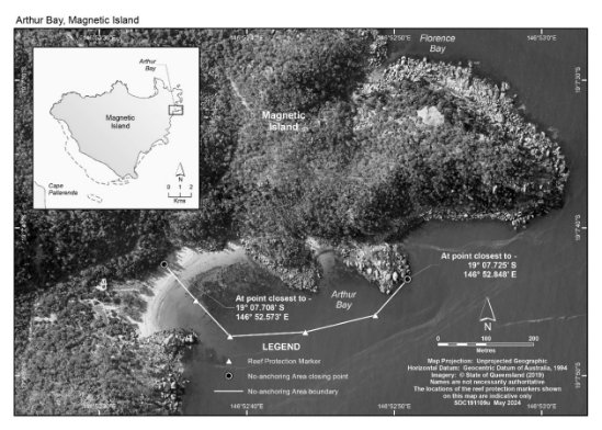
1 Magnetic Island—Arthur Bay
The following map shows the no‑anchoring area at Arthur Bay, Magnetic Island.
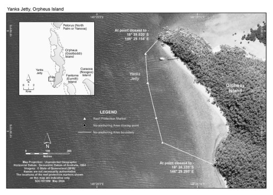
2 Orpheus Island—Yanks Jetty
The following map shows the no‑anchoring area at Yanks Jetty, Orpheus Island.
Part 2—Bowen
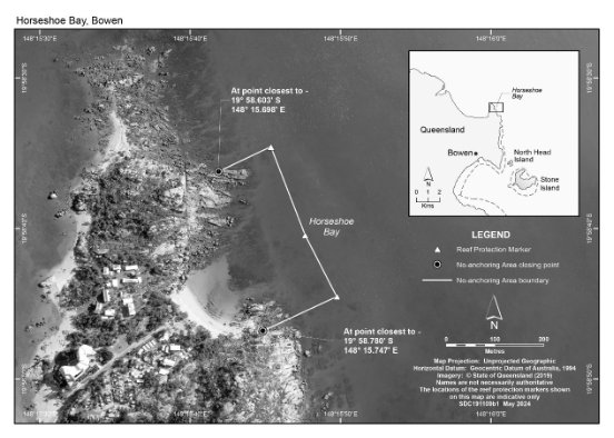
3 Bowen—Horseshoe Bay
The following map shows the no‑anchoring area at Horseshoe Bay, Bowen.
Part 3—Whitsunday Planning Area
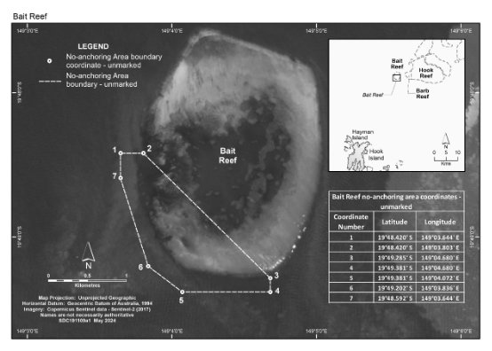
4 Bait Reef
The following map shows the no‑anchoring area at Bait Reef in the Whitsunday Planning Area.
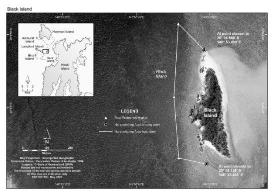
5 Black Island
The following map shows the no‑anchoring area at Black Island in the Whitsunday Planning Area.
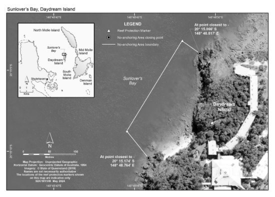
6 Daydream Island—Sunlover’s Bay
The following map shows the no‑anchoring area at Sunlover’s Bay, Daydream Island, in the Whitsunday Planning Area.
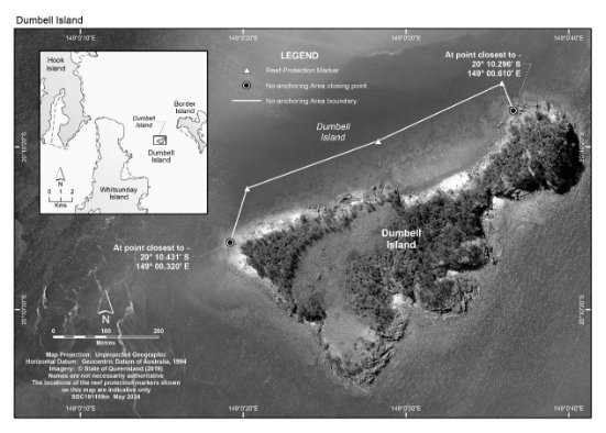
7 Dumbell Island
The following map shows the no‑anchoring area at Dumbell Island in the Whitsunday Planning Area.
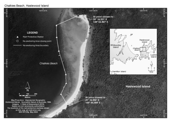
8 Haslewood Island—Chalkies Beach
The following map shows the no‑anchoring area at Chalkies Beach, Haslewood Island, in the Whitsunday Planning Area.
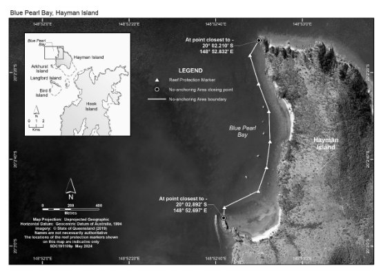
9 Hayman Island—Blue Pearl Bay
The following map shows the no‑anchoring area at Blue Pearl Bay, Hayman Island, in the Whitsunday Planning Area.
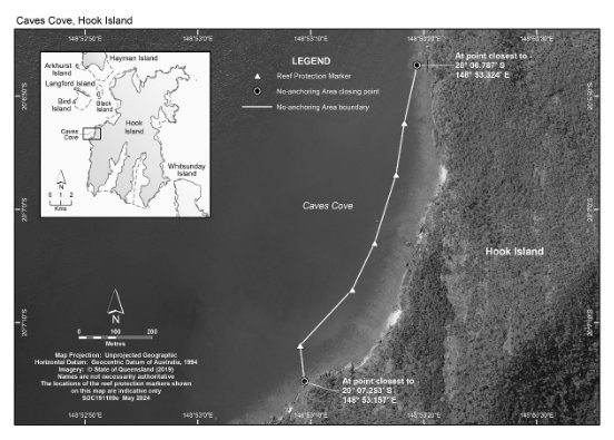
10 Hook Island—Caves Cove
The following map shows the no‑anchoring area at Caves Cove, Hook Island, in the Whitsunday Planning Area.
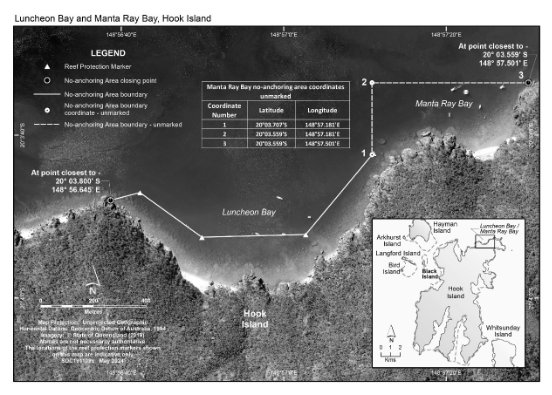
11 Hook Island—Luncheon Bay and Manta Ray Bay
The following map shows the no‑anchoring area at Luncheon Bay and Manta Ray Bay, Hook Island, in the Whitsunday Planning Area.
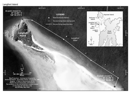
12 Langford Island
The following map shows the no‑anchoring area at Langford Island in the Whitsunday Planning Area.
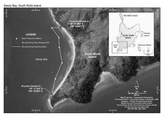
13 South Molle Island—Sandy Bay
The following map shows the no‑anchoring area at Sandy Bay, South Molle Island, in the Whitsunday Planning Area.
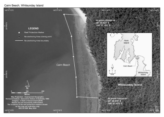
14 Whitsunday Island—Cairn Beach
The following map shows the no‑anchoring area at Cairn Beach, Whitsunday Island, in the Whitsunday Planning Area.
